THE
INFLUENCE
OF
CLIMATIC
FACTORS
UPON
THE
FLASH-FLOODS
OCCURING
IN
THE
SUPERIOR
BASIN
OF
THE
RIVER
MURE
ù
NICOLETA DANIELA GORON
1, MARIUS CIGHER
1, RADU NEGRU
1ABSTRACT. –The Influence of climatic factors upon the flash-floods occuring in the superior basin of the river Mureú .
The floods triggering factors in the upper river basin of the Mures are likely climatic in which case the analysis is based upon a string of data representative for the period 1986-2010, for eight stations and making reference to average rainfall, maximum rainfall within 24 hours, the thickness and duration of snow.The floods in the upper basin of the Mureú do not cause major damage, except in exceptional cases. Most localities that have reported damage caused by floods are located near the TopliĠa-Deda gorge, an area that influences flow concentration through a relatively narrow territory compared to the upstream territory where the Mureú river gathers its tributaries.
Key words: the influence of precipitation upon the formation of flash-floods
1. General considerations
The superior river basin of Mureú is situated in the central-north part of the
country on the territories of the counties of Harghita and Mureú, bordered by the
river basin of Someúul Mare at the North-West, the Siret river basin at the East side
and the Olt river basin at its sounthern side.
A major influence upon the formation and evolution of flash-floods within the superior river basin of Mureú (fig 1) is played by the climatic factors which in turn are influenced by the geomorphologic factors. This is exemplified by two areas mainly the gorge area of TopliĠa-Deda characterized through the concentration of humid air masses within a narrow space implying a higher pressure upon the hydrodynamics and a second area, the Giurgeu Hollow (fig 1) where the air masses now depleted of precipitation and the lesser concentration effect induced by the geomorphologic elements pose a lesser pressure upon the formation and evolution of flash-floods.
This study is based on the analysis of statistical data strings representing quantitative parameters for: mean annual precipitation recorded at three stations in the analyzed region for the 1986-2010 interval, the maximum rainfall recorded within 24 hours also for the 1986-2010 interval, the duration and thickness of snow cover in the region during the period of 25 years.
The geomorphological factors influence the climatic factors as well as the evolution of the flash-flood itself, leaving their mark through morphometric elements specific to the mountain area: steep slopes conducive to rapid developments streams, high altitude, relatively elongated shape of the studied river basin and the subasins.
Fig.1.The geographic units within the upper river basin of Mureú
The oblong shape of the Mureú river basin determines a higher attenuation and hence a diminished power that characterizes the transport and erosion functions of the flood.
exhibition of the river tributaries. Generally a uniform exhibit of slopes where RastoliĠa, and TopliĠa are slightly opriened to the SE prevails.
The slope cathegory prevalence influences the drainage coefficients thus affecting the concentration and propagation velocity of the flood, so that in the case of similar river basins that differ only in terms of slope cathegory, the flood increase time will be shorter and the negative aspects will be more violent in the case of the basin with higher slopes.
The vegetation cover is rather dense, the forests being dominant within the superior sector of the Mureú river, especially in the sector of TopliĠa-Gălăoaia fact that constitutes a factor that attenuates the velocity and amplitude of flash-floods.
Due to its lower altitude (500-600m) the gorge area of TopliĠa-Deda constitutes, from the point of view of temperature and vegetation, a tentacle coming from the western hill region, as the average anual temperature of 6-8° C characterizes the area that ranges as far as the Lunca Bradului locality and accompanying them are the deciduous forests that gradually make way for the mixt forests. (Ujvari,, 1972, Schreiber, W, 1983).
Tabelul 1 – The average multiannual rainfall within the superior river basin of Mureú
River Station Altitude (m)
Surface
kmp Lenght km
Average multiannual rainfall (mm)
Mureú Suseni 987 160 19 518
Mureú TopliĠa 935 1071 77 619
Mureú Stânceni 967 1532 98 658
Mureú Gălăoaia 988 2135 127 887
Belcina Gheorgheni 1115 94 31 586
RăstoliĠa RăstoliĠa 1174 163 20 780
Bistra Bistra 1104 92 25 725
The influence of the relief through altitude is exemplified by the correlation between this parameter and the multiannual average amount of precipitation falling upon the basins of Bistra (the hydrometrical station is located at an altitude of 1104m, and the registered rainfall amount is 725mm/m2/year)
comparative to RăstoliĠa (the hydrometrical station being located at a higher altitude than the one at Bistra 1174m, respectively and the amount of rainfall registered here on an annual basis is 780mm/m2/year).
The effect of orographic barrier enforced by the mountain upon the depression nearby is described through the more reduced quantities of rainfall registered annually at the stations of Suseni (518mm/m2/year) and Gheorgheni (586 mm/m2/year), where
The rainfall quantity evolution within the superior river basin of Mureú as well as the influence of the relief upon it can be observed by studying the reduction of precipitation quantity starting from the hydrometrical station of Gălăoaia, situated at the entrance in the gorge area where the humid air masses summarize a total quantity of 887mm/m2/year and the hydrometrical station of Suseni situated
near the Mureú source within the Gheorgheni depression where the annual precipitation quantity only reaches 518mm/m2/year.
But, the main factors that influence the genesis of flash-floods are the meteorological ones: the precipitation quantity received by the river basin throughout a year (this factor influences through intensity, duration and surface, and therefore the most important element that one needs to take into consideration is the maximum amount of precipitation that fell upon the river basin within 24 hours ) the evolution of temperature throughout the year (the hot air masses being one of the key factors in the genesis of winter flash floods ).
2. The rainfall regime within the superior river basin of Mure
ú
Precipitation in both liquid and solid form poses a direct influence in triggering flash-floods. The ones in liquid form generate an immediate effect especially in the case of smaller hydrographical basins. The solid precipitation constitutes a decisive factor in triggering the formation of flash-floods during winter time when positive temperatures are being registered throughout the area generating snow melt.
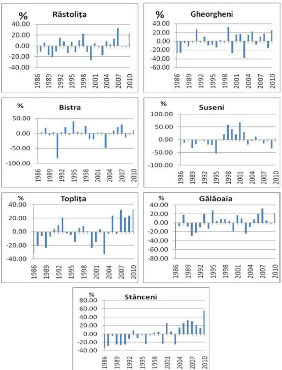
The fluctuations of annual precipitation quantity within the superior river basin of Mureú are rendered through the positive and negative deflections when compared to the multiannual average.
By analyzing the graphics more important features may be stated.
Due to the direct implication in flash-flood genesis, the positive deflection situations have been emphasized.
The greatest positive deflections in what concerns the precipitation that fell upon the Mures river basin during a year vary between 150-370mm apart from the multiannual average that characterizes the period of 1986-2010.
The greatest positive deflections that were registered within the superior river basin of Mureú were the ones at Suseni in 2001 when the excess of precipitation was calculated at 349mm, Stânceni in 2010 when the annual rainfall quantity exceeded the multiannual average by 368mm.
The year of 2007 also stands out with an excess of precipitation that varies from 200mm at TopliĠa to 258 at RăstoliĠa.
Fig. 2. The annual rainfall quantity deflections within the upper river basin of Mureú on a
2.1 The statistic analysis of the maximum precipitation recorded within 24 hours in the superior river basin of Mureú
The present study is based on strings of data coming from eight hydrometrical stations and three meteorological stations regarding maximum annual precipitation, maximum precipitation measured within 24 hours, or on a monthly basis collected for the period of 1986-2010 from the stations of Stânceni, TopliĠa, Gălăoaia, Suseni, upon Mureú and RăstoliĠa, Bistra, Gheorgheni upon the tributaries.
Fig.3. – The average maximum rainfall within 24 hours in the upper river basin of Mureú
On a general basis the maximum rainfall within 24 hours upon the superior river basin of Mureú presents a uniform distribution on the entire area, the amount varying annually within 35-40 mm/mp/an these quantities being supported by geomorphologic factors especially in the gorge are thus determining the concentration of humid air masses.
Tabel 2 – The quantity of rainfall over the superior river basin of Mureú within 24 hours on
a monthly basis
Lunile Nr
crt
StaĠia
hidrometrică I II III IV V VI VII VIII IX X XI XII
The area most screened from precipitation is the one located near the source of the river Mureú and due to the orographic barrier constituted by the mountains the air masses reach this area depleted of precipitation, and thus the lowest amount of maximum precipitation registered in 24 hours that occurs here. Due to this fact but also due to the inchoative state in the evolution of the hydrographic basin, the amplitude and frequency of flash-floods within this area is diminished.
Overall all the eight stations reported a maximum precipitation quantity recorded annually within the period of July-August. Thus the most extensive flash-floods that affected the area during the years of 1998, 2000 úi 2005 were generated by the maximum rainfall recorded on a multiannual basis: 44,6 mm/m2 at Suseni and 41,3 mm/m2 at TopliĠa both on the 16th of July 1998, 41mm/m2 at Gălăoaia on
the 13th of July 2000, and 50,6 mm/m2 at Stânceni on the 13th of July 2005.
Tabelul 3. – The repartition of maximum precipitation within 24 hours on the superior
river basin of Mureú
Nr of days with
pecipitation Stânceni Gălăoaia Suseni TopliĠa Bistra Gheorgheni RăstoliĠa
0-4.99 mm 112 90.8 84.04 116.6 66.8 97.16 79.6
5-9.99 mm 26.4 31.24 24.92 23.76 24.6 23.76 30.08
10 mm 17.24 27.72 10.64 16.84 22.84 14.96 23.04
By drawing the maximum rainfall quantity within 24 hours, for every month of every year within the period of 1986-2010 one was able to calculate the repartition of maximum rainfall considering the quantities reported by each hydrometric station within the superior river basin of Mureú. Furthermore the values were grouped into three categories: above 10 mm, between 5-9,9 mm and 0-4,99 mm (table 3).
The rainfall of exceptional cases that manifests great impact upon the flash-flood genesis are part of the first and less frequent category on an annual basis.
3. Snow cover analysis
Snow melt is one of the factors influencing the genesis of spring floods, and it is far more dangerous when it is associated with high rainfall during the same season.
The duration of the snow cover depends on the amount of solid precipitation as well as the period of time during which the soil temperature is maintained at 0 ° C. With the first decade of October in the case of the higher altitude meteorological station Bucin and the second decade of October for the meteorological station of Joseni snow cover is possible except for the eastern slopes and valley corridors, located at lower altitudes compared to the average altitude of the region, where the first layer of snow occurs in November (weather station TopliĠa).
At the Bucin weather station (altitude 1272m) the snow cover maintains for an average of eight months a year, the opposite being TopliĠa meteorological station where snow remains for a median of 6 months per year, due to its location in the gorge of TopliĠa-Deda, under the influence of warmer air currents. The average depth of snow can reach up to 80 cm, at the highest meteorological station in the region during the first decade of March, but due to the rapid heating of air temperature (monthly average amplitude between the months of March and April at the Bucin station range between 2-6 ° C over the period 1986-2010) during the first decade of April it can reach half of that amount (40 cm).
Fig.5. The evolution ofthe averagethicknessof snowwithin a yearat
theBucinmeteorological station
snow recorded in this area in the 1986-2010 interval is 12 cm recorded in the last decade of December and the first decade of January (Fig. 3). A first sharp melting of the snow occurs between the first and second decades of March, when the snow ranges from a thickness of 10 cm in early March to 6cm in the mid of same month given the average amplitude during the period of 1985-2010 that has been ranging between 4-10 ° C.
Fig. 6. The evolution ofthe averagethickness of snow within a year at
the Joseni meteorological station.
The fact that most of the spring floods registered at the hydrometrical station of Suseni upon Mures take place mainly in the first decade of March thus coinciding with the melting of snow in the area indicates a preponderance of a mixed type of flood.
Fig. 7. The evolution ofthe averagethicknessof snowwithin a yearat
The gorge area of TopliĠa-Deda is characterized by the climatic data from the meteorological station of TopliĠa located at an altitude of 669m. Snow depth reaches the maximum rate averaged at 18 cm during the first two decades of February. The phenomenon of rapid melting of the snow a key factor in the genesis of flash-floods during this time of the year, takes place starting with the first two decades of March, when the snow reaches an melts sharply from a thickness of 14cm during the first decade to 8cm during the second decade and finally measuring only 2cm in late March.
4. Conclusion
The main factors influencing the genesis of floods in the upper basin of the Mureú river are the meteorological ones, mainly the amount of precipitation falling upon the basin surface and under the influence of temperature variation especially during the winter and spring season the melting of the snow (warm air masses working together directly to the genesis of winter floods).
Most floods in the upper basin of the Mures are spring floods with a mixed genesis, followed by the summer floods generated by liquid precipitation. In terms of a monthly analysis considering a period of 25 years at eight hydrological stations April emerges as the month when floods occur most frequently in this area.
REFERENCES
1. Arghiuú, V. (2008) Studiul viiturilor de pe cursurile de apă din estul MunĠilor Apuseni úi Riscurile asociate, Edit. Casa CărĠii de ùtiinĠa, Cluj-Napoca.
2. Bilaúco, ùt., (2008), Implementarea S.I.G. în modelarea viiturilor de versant. Studii de caz în bazinul Someúului Mic, Teză de doctorat, Cluj-Napoca.
3. Centea, R., (1974) Scurgerea maximă în bazinul hidrografic Mureú, Teză de doctorat,
Cluj-Napoca.
4. Makkai, G, Moldovan, F (2000), Factorii meteorologici care au favorizat inundaĠiile din bazinul superior al Mureúului din luna aprilie 2000, În vol Analele UniversităĠii
“Dimitrie Cantemir” din Târgu-Mureú, SecĠiunea Geografie-Istorie, p. 175-182. 5. Pandi, G., (2010), Undele de viiturăúi riscurile induse, , În vol. “Riscuri úi catastrofe”,
II, Editor Sorocovschi, V., Edit. Casa CărĠii de ùtiinĠă, Cluj-Napoca, p. 55-66.
6. Pandi, G., Mika, I., (2003), River runoff extremes and tendencies: factors of risk likely related to global climate, În vol. “Riscuri úi catastrofe”, II, Editor Sorocovschi, V., Edit. Casa CărĠii de ùtiinĠă, Cluj-Napoca, p.116-129.
7. Romanescu, Gh., (2003), InundaĠiile- între natural úi accidental, În vol. “Riscuri úi
catastrofe”, II, Editor Sorocovschi, V., Edit. Casa CărĠii de ùtiinĠă, Cluj-Napoca, p. 130-138.
9. Sorocovschi, V., (2003), Riscurile hidrice, În vol. “Riscuri úi catastrofe”, I, Editor
Sorocovschi, V., Edit. Casa CărĠii de ùtiinĠă, Cluj-Napoca, p. 55-65.
10. Sorocovschi, V., (2003), Complexitatea teritorială a riscurilor úi catastrofelor, În vol.