EXAMINATIONS ON DEVELOPMENT OF THERMAL EXCESS IN
SUBURBAN AREAS OF DEBRECEN, HUNGARY
SZEGEDI S. 1, CSÁKBERNYI-NAGY G. 2, LÁZÁR I. 1, TÓTH T. 1
ABSTRACT. Examinations on development of thermal excess in suburban areas of Debrecen. Effects of synoptic conditions on development of urban thermal excess, the urban heat island (UHI) are presented in this paper. Temperature datasets have been recorded at two heights by three automatic weather stations mounted in Debrecen (east Hungary) and a small settlement inits vicinity. An additional automatic weather station is used as a reference station outside Debrecen. UHI intensities have been calculated and the impact of synoptic conditions have been analyzed on the base of Péczely’s macrosynoptic types. We have found that anticyclone types are much more favorable from the aspect of UHI development, while cyclone types, especially the passage of warm fronts can effectively hinder the formation of strong heat islands in Debrecen.
Keywords: automatic weather stations, urban heat island, Debrecen, synoptic conditions, Péczely’s macrosynoptic types
1. INTRODUCTION
As a result of urbanization boom, approximately three billion people – nearly the half of the population of the World –live in cities in the first decades of the third millennium. The acceleration of urbanization has triggered widespread environmental problems. These adverse effects impact on a dynamically increasing population directly with the growth of cities. Meteorological and climatologic consequences are among the most important issues. The altered physical characteristics of artificial urban surfaces and change of chemical composition of atmosphere in the cities lead to deterioration of air quality and changes of each meteorological element compared to areas outside cities (Landsberg 1981). The term "urban climate" refers to the unique local climate of the built-up urban spaces, significantly different from the climate in rural areas (Oke, 1997). The present work deals with one of the most remarkable phenomena of urban climate, the thermal excess in the cities compared to the rural countryside, called urban heat island (UHI).
Changes of climate elements in built-up urban spaces arise from alterations in the energy and water budget in cities, principally (Chen et al. 2014).
1University of Debrecen, Department of Meteorology, Debrecen, Hungary
e-mail: [email protected], [email protected], [email protected]
2Alter Energia Kft., Debrecen, Hungary
e-mail: [email protected]
102
Temperatures show a sudden increase at the border of a buildup area called the “cliff”, than gradually increase through the suburban areas called the “plateau” and increase strongly again forming a “peak” in the city center (Oke, 1987). Potential UHI intensities (the maximal thermal difference between the city and its unbuilt environment) are determined by the size, population and built-up structure (ratio of non-evaporating surfaces, sky view factor) of settlements mainly (Krüger and Emmanuel 2013). It means that great cities with compact buildup structures generate stronger urban climate with more intense heat islands than small ones (Oke, 1973).
Heat island development has a special diurnal and annual course. UHI intensities reach their maxima 3-5 hours after sunset in the settlements examined all over the world. Strongest heat islands develop in the late summer-early autumn or in the winter depending on climate zones and regions (Vardoulakis et al. 2013).Meteorological conditions – cloud cover, wind speeds and precipitation – have a determinant impact on the development of the heat island at a certain moment (Unger 1996, Unger et al. 2001).
The border between the settlement and its environment has an important position from the aspect of the heat island development: the “cliff” is located in that zone, where horizontal thermal gradients can reach 1 °C/100 meters. Strong cliffs can be found in areas only where the border between the buildup and unbuilt areas is sharp (Szegedi et al. 2013). Suburban areas occupy the major part of the settlements. They are characterized by low or medium heat island intensities (Szegedi et al. 2013) consequently, they are more sensitive from the aspect of synoptic conditions than city centers, where heat islands are the most intense. For this reason our main aim was to trace the impact of synoptic conditions on the development of urban heat island in the “cliff” and "plateau" zones of Debrecen.
2. STUDY AREA AND METHODS
Temperature profile datasets were gathered at four sites: one used as a reference and three sites in suburban areas in and outside the city of Debrecen. They are situated in similar physical geographic environment with low relief, elevation, almost the same vegetation cover without large water bodies. The main difference lies in the buildup characteristics of the environment of the sites.
Site 1 is the Weather Station of the University of Debrecen (UDWS). This site has the most complex neighborhood since it is situated on the edge of different urban climate zones:
• a high density residential area, a housing estate with high raised blocks of flats: urban climate zone 2 (Oke, 2004);
• a low density residential area, 1-2 storied houses with gardens: urban climate zone 5;
• public institutions with large green areas, the UD main campus with sports grounds, parks and high buildings: urban climate zone 6;
• the close-to-natural forest of the “Nagyerdő”:urban climate zone 7.
Site 2, the Renewable Energy Park (REP) is situated in a low density residential area, 1-2 storied houses with gardens:urban climate zone 5. Additionally, an industrial park (urban climate zone 4) with medium height light structure buildings can be found in its vicinity.
Site 3 is located in a low density residential area, 1-2 storied houses with gardens in a small settlement (suburb) 10 km off Debrecen. It can be classified as urban climate zone 5. We used it as a control site.
Site 4 is the Agrometeorological Observatory of the Center of Agricultural Sciences of the University of Debrecen used as the reference site 5 km off Debrecen in an agricultural area.It belongs to urban climate zone 7. Fig. 1 shows the location of the measurement sites.
Fig. 1. Location of the measurement sites
Resistance thermometer sensors have been mounted with an accuracy of ±0.1 °C on columns to heights of 2 and 10 meters at each measurement site. Data gathered by the sensors has been recorded on digital data logger units. Sampling intervals have been set to 10 seconds, while averaging interval is 10 minutes. Datasets have been processed in Microsoft Excel 2010. Results presented here represents the measurement period between 19 October-31 and December 2013.
3. RESULTS AND DISCUSSION
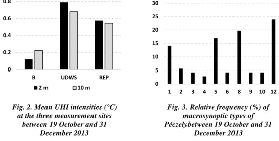
In order to gain comparable values UHI intensities were calculated from raw measurement data for 2 and 10 meters for each site by subtracting temperature data measured at the reference station from temperature data of the measurement sites. Mean UHI intensities of the studied period at the three sites are presented in Fig. 2. It can clearly be seen that the order of the sites is UDWS, REP and Bocskaikert. It is in accordance with our assumptions, since the environment of the UDWS belongs to the urban plateau, while the REP is located in the zone of the cliff and Bocskaikert is a control site outside the city.
A bit higher UHI intensities have been found closer to the surface (Fig. 2). However, there are not significant differences in the values at 2 and 10 meters at the three sites: differences do not exceed 0.3°C.
Effects of synoptic conditions on development of UHI have been analyzed on the base of Péczely's macrosynoptic types. Table 1 presents the 13 macrosynoptic types of Péczely. Types are determined using front maps of Europe of the Hungarian Weather Service for 0 hour UTC each day by dr. Csaba Károssy. Generally, anticyclone types are advantageous for UHI development, while cyclone types hinder the development of strong a UHI, due to cloudy and windy weather and rain connected to them.
Fig. 3 presents the relative frequency of macrosynoptic types of Péczely in the studied period. It can be seen that types 7 (zonal cyclone), 11 (anticyclone over the Fennonscandinavian region) and 13 (cyclone over the Carpathian Basin) had not occurred during the studied period.
The frequency of types 2 (anticyclone over the British Isles), 3 (Hungary lies in the rear of a Mediterranean cyclone), 4 (Hungary lies in the fore part of a western European cyclone), 6 (Hungary lies in the fore part of a Mediterranean cyclone), 9 (anticyclone south of Hungary) 10 (anticyclone north of Hungary) are
Fig. 2. Mean UHI intensities (°C) at the three measurement sites
between 19 October and 31 December 2013
Fig. 3. Relative frequency (%) of macrosynoptic types of Péczelybetween 19 October and 31
December 2013
0 0.2 0.4 0.6 0.8
B UDWS REP
2 m 10 m 0
5 10 15 20 25 30
1 2 3 4 5 6 8 9 10 12
around 5%. The most frequent types are 12 (anticyclone over the Carpathian Basin), 8 (anticyclone extending from the west), 5 (anticyclone east of Hungary), and 1 (Hungary lies in the rear of a western European cyclone).
Table 1. Codes, letter codes and short descriptions of the Péczely's macrosynoptic types
No. Codes Descriptions
Types connected with northernair currents(type-group MN) 1 mCc Hungary lies in the rear of a western European cyclone 2 AB anticyclone over the British Isles
3 CMc Hungary lies in the rear of a Mediterranean cyclone Types connected with southernair currents (type-group MS) 4 mCw Hungary lies in the fore part of a western European cyclone 5 Ae anticyclone in the east of Hungary
6 CMw Hungary lies in the fore part of a Mediterranean cyclone Types connected with western current (type-group ZW) 7 zC zonal cyclone
8 Aw anticyclone extending from the west 9 As anticyclone in the south of Hungary
Types connected with easternair currents (type-group ZE) 10 An anticyclone in the north of Hungary
11 AF anticyclone over the Fennonscandinavian region Central types
12 A anticyclone over the Carpathian Basin 13 C cyclone over the Carpathian Basin
Normally, anticyclone types are more frequent in the Carpathian Basin, they govern the weather of Hungary for weeks in the midwinter and midsummer-early autumn periods. However, late autumn and midsummer-early winter weather is ruled by cyclones formed over the North Atlantic or the west Mediterranean Seas.
Anticyclone macrosynoptic types are favorable for Development of intense urban heat islands: the lack of rain, calm winds and undisturbed radiation conditions help the development of the thermal excess in the buildup areas of the settlements. Warm and cold fronts of midlatitude cyclones cause windy, cloudy and often rainy weather, what is absolutely unfavorable for UHI development. Especially, slow moving warm fronts are effective in preventing the formation of heat islands (Szegediet al. 2013). On this base we assumed that anticyclone types will be found to be favorable and cyclone types will be proved to be unfavorable from the aspect of UHI development in the studied period.
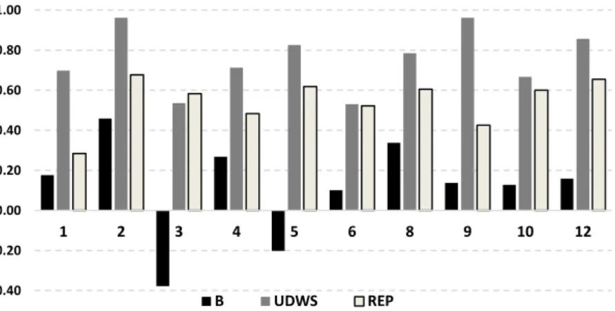
Fig. 4 shows the mean UHI intensities of different macrosynoptic weather types at the three sites at 2 meters in the studied period. Weak heat islands have been found in types 1 (Hungary lies in the rear of an eastern European cyclone), 3 (Hungary lies in the rear of a Mediterranean cyclone), 4 (Hungary lies in the fore part of a western European cyclone), 6 (Hungary lies in the fore part of a
Mediterranean cyclone) and 10 (anticyclone north of Hungary). With the exception of type 10 they are cyclone types, what supports our hypothesis.
High intensities are associated with types 2 (anticyclone over the British Isles), 5 (anticyclone east of Hungary), 8 (anticyclone extending from the west), 9 (anticyclone south of Hungary) and 12 (anticyclone over the Carpathian Basin). All of them are anticyclone types what proves that our assumption was right.
Fig.4. Mean UHI intensities (°C) of macrosynoptic types of Péczelybetween 19 October and 31 December 2013
Days of highest and lowest UHI intensities haves been analyzed as well. The first and third highest intensity heat islands have been detected under macrosynoptic conditions when anticyclones in the east of Hungary ruled the weather of the Carpathian Basin. This Type is one of the most favourable ones for heat island development according to our previous studies (Szegedi– Kircsi 2003).
The second strongest UHI occurred under cyclonic conditions, when a cold front of a western European cyclone formed the weather of our region.
Table 2. Highest and lowest intensity urban heat islands between 19 October and 31 December 2013 with their Péczely's macrosynoptic codes
high intensity heat islands low intensity heat islands Date intensity (°C) code Date intensity (°C) code 29 12 2013 4.66 05 (Ae) 03 11 2013 0.98 01 (mCc) 20 12 2013 3.98 01 (mCc) 18 11 2013 0.94 10 (An) 26 12 2013 3.94 05 (Ae) 25 11 2013 0.91 03 (CMc)
Generally, this type is not favorable for UHI development when it follows a slow moving warm front, but in the days before that case an anticyclone over the Carpathian Basin established a strong heat island, what could resist the passage of the fast moving cold front.
The lowest intensity heat island occurred under cyclone conditions when a cold front of a Mediterranean cyclone passed over the Carpathian Basin after a
-0.40 -0.20 0.00 0.20 0.40 0.60 0.80 1.00
1 2 3 4 5 6 8 9 10 12
B UDWS REP
slow moving warm front. The two fronts could effectively eliminate the development of the thermal excess in the city. The second weakest UHI occurred under an anticyclone type, when cold air masses filled the Carpathian Basin, fog and stratus clouds hindered the formation of the UHI. It is mirrored in the 2 and 10 meters data what show an inverse thermal profile. The third weakest heat island developed when a cold front of a western European cyclone passed over our region. In that case relatively strong winds caused the weak UHI.
4. CONCLUSIONS
Our results have proved that synoptic conditions determine the possibility of the formation of the UHI. Péczely's macrosynoptic classification is an effective tool for determination of conditions of UHI development. Most favorable conditions are those, when anticyclones govern the weather of the Carpathian basin due to low wind speeds and cloudiness connected to them. However frequent thermal inversions in the winter period cause problems from this aspect.
In some cases 24-48 hours after a cold front strong heat islands could develope. The different heat budget of the natural and artificial surfaces manifested more clearly under such circumstances. It means that a fast moving cold front does not eliminate the development of UHI completely. Slow moving warm fronts, followed by fast moving cold fronts could eliminate the development of the UHI or could destroy a well-developed UHI more effectively. During or shortly after the passage of a strong warm front weak heat islands were detected only.
Results emphasize the importance of the synoptic conditions of 2-3 day long periods before measurements. Since artificial surfaces accumulate significant amounts of heat from one day to another, the development of a strong heat island is a several day long process. For this reason a short unfavorable weather event (e.g. a cold front without a heavy rainfall) can not eliminate completely a well developed heat island. On the other hand, after 2-3 day long periods of disadvantageous macrosynoptic conditions, strong heat island could not develop within a 24 hour long favorable period.
The authors suppose that on the base of a one year long (or even longer) time series of UHI intensities and macrosynoptic types they will be able to elaborate an empirical UHI intensity forecasting model.
ACKNOWLEDGEMENTS. The work/publication is supported by the TÁMOP-4.2.2.A-11/1/KONV-2012-0041 project. Authors would like to thank Prof. hc. Gábor Szász and Csaba Rácz for the meteorological datasets of the Agrometeorological Observatory of the Center of Agricultural Sciences of the University of Debrecen; and dr. Csaba Károssy for the Macrosynoptic types of the studied period.
REFERENCES
1. Chen, F., Yang, X., Zhu, W. (2014), WRF simulations of urban heat island under hot-weather synoptic conditions: The casestudy of Hangzhou City, China,
Atmospheric Research 138, 364-377.
2. Károssy, Cs (2014), 2014.01.18 - 48 personal communication.
3. Krüger, E., Emmanuel, R. (2013), Accounting for atmospheric stability conditions in urban heat island studies: The case of Glasgow, UK, Landscape and Urban
Planning 117, 112-121.
4. Landsberg, H.E. (1981), The Urban Climate, Academic Press, New
York-London-Toronto-Sydney, San Francisco, pp. 83-126.
5. Oke, T.R. (1973), City size and the urban heat island, Atmospheric Environment
7,769-779.
6. Oke, T.R. (1987), Boundary Layer Climates, Routledge, London-New York, 405.
7. Oke, T.R. (1997), Urban climates and global,environmental,change, Applied
climatology (Eds. Thompson, R.D. and Perry, A.), Routledge, London and New
York, 273-287.
8. Oke, T.R.(2004), Urban observations, World Meteorological Organization, IOM
Report N_ 81, WMO/TD n_1250.
9. Szegedi, S., Kircsi A. (2003), The Development of the Urban Heat Island under Various Weather Conditions in Debrecen, Hungary, Klysik. K., T.R. Oke, K.
Fortuniak, C.S.B. Grimmond, J. Wibig (ed.) Proceed. ICUC-5, Lodz, Poland, vol. 1, 139-142.
10.Szegedi, S., Tóth, T., Kapocska, L., Gyarmati, R. (2013), Examinations on the factors of urban heat island development in small and medium-size d towns in Hungary, Carpathian Journal of Earth and Environmental Sciences(8) 2: 209-214.
11.Unger, J.(1996), Heat island intensity with different meteorological conditions in a medium-sized town: Szeged, Hungary, Theor. Appl. Climatology 54, 147-151.
12.Unger, J.,Sumeghy, Z., Gulyas, A., Bottyan, Z. and Mucsi, L.(2001), Land-use and meteorological aspects of the urban heat island, Meteorol. Applications,
8,189-194.
13.Vardoulakis, E., Karamanis, D., Fotiadi, A., Mihalakakou, G. (2013), The urban heat island effect in a small Mediterranean city of high summe rtemperatures and cooling energy demands, Solar Energy 94, 128-144.