URBAN AND ENVIRONMENTAL TRANSFORMATIONS IN POOR AREAS OF
THE METROPOLITAN REGION OF RECIFE (BRAZIL)
1
KAINARA LIRA DOS ANJOS2
NORMA LACERDA3
Introduction
In the last two decades, the process of occupation of public and private lands in large Brazilian cities, as well as the irregular and clandestine land subdivisions- which gave rise to a significant number of settlements emerged mainly in the 1970s and 1980s - experienced a significant reduction. This process has been gradually replaced by the in-formal real estate market, thus linking sale and rental transactions of homes, especially in consolidated areas. The importance of this market as a means of access to housing is recognized by the authors who have studied this phenomenon in the world (Davis, 2006) and also in Latin America and Brazil (ABRAMO, 2003 and 2007; BALTRUSIS, 2005).
With regard to the Metropolitan Region of Recife (RMR), the research enti-tled Funcionamento do mercado de habitações em áreas pobres da Região Metropolitana do Recifei(Housing market operation of in poor areas of the Metropolitan Region of Recife), con-ducted by the Grupo de Estudos sobre o Mercado Fundário e Imobiliário (Gemfi) and performed from October to December 2005, revealed that the informal rental market, when compared to the sale market, plays an important role when considering all real estate transactions. But, would not the changes caused by the relevance of that market be contributing to a series of transformations in urban and environmental structures of many of the popular consolidated settlements? Would not these changes be contributing to environmental degradation of these settlements?
Given this situation, the present text aims to analyze the social and environmental impacts arising from the dynamization process of the rental market in recent years, whose object of study is Brasília Teimosa, area where this market showed a greater dynamism among those that were studied in RMR.
1. A first version of this paper was presented in the 8th International Conference Virtual City and Territory, held in Rio de Janeiro (Brazil), on 10 to 12 October 2012.
To achieve this goal, the text was structured in three parts. In the first part, we discuss the emergence of the recent dynamics of occupation in poor areas: the infor-mal real estate market. For this, we use data from field surveys performed in 2005 and 2008/2009. In the second one, we analyze urban and environmental changes in Brasília Teimosa with emphasis on their habitability conditions. In the third one, we analyze the relationship between the expansion of the real estate rental market in poor areas, called by the authors as MIAP, and its implications in terms of environmental degradation. In order to do this, we made use of the indicators of urban environmental dimension proposed by Anjos (2013) and defined from urban regulator parameters of land occupation, these being: (i) occupation rate (ii) building density; and (iii) vegetation cover.
Recent occupation dynamics in poor areas: informal real estate market
For a long time, the question of informal real estate market was treated as a secon-dary theme in researches on urban and housing development. The absence of this topic became evident among researches and texts which explained the growth of the “clan-destine” or “irregular” city as part of a migration process (countryside - city), considered explanatory of the accelerated urbanization process (KOWARICK, 1979; PASTERNAK, 1989; MARICATO, 1979). This process becomes evident when we make use of demo-graphic data: until the mid-twentieth century, the resident population of the cities did not reach 30%, but in the 1990s it exceeds the 80% mark.
The central questions of the researches mentioned above were the accentuated process of precarization of large Brazilian cities and housing policies aimed at low-income popula-tions, more specifically, that one relating to the construction of housing complexes in the urban periphery, meaning the relocation of residents who lived before in more central areas.
Parallelly with these themes, another mobilized a part of the academy. It was the theoretical debate that developed in Brazil in the early 1980s around the formal real estate market, i.e., the accumulation pattern of the housing sector. It was from the late 1990s and early 2000 that the research on the reproduction of the informal city takes on a new approach: the informal real estate market. Researches on this phenomenon in the world (DAVIS, 2006) and also in Latin America and Brazil (ABRAMO, 2003 and 2007; BALTRUSIS, 2005) are performed.
Researches of Abramo (2003; 2007) constitute an economic theory on the favelas, while the Baltrusis (2005) highlights the existence of a new segment of real estate market: the informal submarket that seeks to cater, preferably, the low-income population which has neither access to formal market nor the State housing provision programs.
The informal market, as well as the formal, it consists of sale and rental market. With respect to the latter, Davis (2006) points out the tendency of literature on informal hou-sing, both popular and academic, in romanticizing the invaders and ignoring renters. In this sense, points out that
to generate income with their patrimony (formal or informal), but frequently, this occurs in an exploitation relationship of people even poorer. (DAVIS, 2006, p.52).
With regard to Latin America, research conducted by Abramo (2007) indicates that the degree of importance of sale and rental markets can vary among countries. While in some countries sale market is significant, in others the rent is the main form of access of the poor to housing. In Colombia, Venezuela and Argentina, the highest percentages of real estate transactions, respectively, 80.24%, 61.93% and 67.61% corresponded to real estate lease. In Brazil, the survey conducted in Rio de Janeiro, without computing the Borel and Jacarezinho communities, found that the participation of this market reaches 29.73%. This situation reveals that Latin America experiences shared phenomena that certainly reveal singularities. Hence the need to disclose them in order to recognize the specific local conditions.
Regarding the RMR, the survey performed in 2005 covered four poor areas - Bra-sília Teimosa, Mustardinha and Pilar, located in Recife, and Passarinho, in Olinda - all of them were consolidated and selected because they have different situations on the topology, the location in relation to the center of Recife, the provision of services and urban infrastructure and on the institutional situation, in particular with regard to being or not being Special Areas of Social Interest - Zeis (LACERDA; MELO, 2009).
In this research, unlike what was identified in Rio de Janeiro, it was detected a significant participation of the informal rental market in relation to all the identified real estate transactions in the areas under study: of the total of surveyed properties (385), 57.92% (223) had been rented (Table 1). Comparing the four surveyed areas, the ones which are most highlighted are Brasília Teimosa and Mustardinha, and older areas, where the identified real estate transactions, 72.02% and 66.07%, respectively, correspond to the rent. Conversely in other areas, Passarinho and Pilar, not Zeis areas present the most recent history of occupation; the percentage of rent was not as significant, corresponding to 35.96% and 27.27% respectively. From these data, we can conclude that the rental market influences more powerfully in the most valued areas, consolidated and defined as Zeis, in which is possible to identify an increase in population density and, consequently, the building density.
Table 1: Informal real estate market in RMR (Applied questionnaires)
Communities Sale market Rent Total Transactions (%)Rent/Total
V. abs % V. abs % V. abs %
Pilar 16 9.88 6 2.69 22 5.71 27.27
Mustardinha 19 11.73 37 16.59 56 14.55 66.07 Passarinho 73 45.06 41 18.39 114 29.61 35.96 Brasília Teimosa 54 33.33 139 62.33 193 50.13 72.02
Total 162 100 223 100 385 100 57.92
The fact of having been Brasília Teimosa the location where the rental market works more dynamically was the reason why it was chosen as one of the study areas for a new field research (2008-2009)ii and for validating the indicators proposed by Anjos (2013), which aimed to assess how the expansion of MIAP has contributed to environmental degradation in these areas.
According to Lacerda and Melo (2009), as well as in the formal market - composed territorially of various submarkets due to the spatial differentiation of the areas for the social segments of middle and high income - poor areas are carriers of large differentia-tions. Abramo (2003, p. 210) points out that a differentiation within the slum occurs “in function of the topological characteristics of the land and the temporality of building process: the older the area, more consolidated in terms of buildings in masonry and pro-ximity of trade and service network.”
Recognizing the internal socio-spatial fragmentation of popular settlements and seeking to understand how this recent dynamics of occupation - informal real estate market - takes place in them are essential tasks for identifying environmental attributes, necessary for the construction of tools that allow evaluating the degree of environmental degradation caused by the above-mentioned dynamics.
Urban and environmental transformations in Brasília Teimosa
It is known that most of the popular settlements - whether originated from occu-pations, or as resulting from irregular or illegal land subdivisions - is located in environ-mentally fragile areas. Thus, the analysis of the environmental issues related to use and occupation land process becomes fundamental to provide the basis for the reduction of risks and thereby to contribute to a “ecologically balanced environment”, right guaranteed by the Brazilian Constitution (Art . 225).
The case of the Brasília Teimosa Zeis, located in the drainage basin of Pina, be-tween the center of Recife and the highly valued district of Boa Viagem, is framed in this context. It is located on a sandy peninsula that advances over the sea, being a part of the result of land fill performed in the 1950s with removed material for the expansion of the Port of Recife. Triangular in shape, it is delimited by the sea, by the estuary of Capibaribe, Tejipió and Jordan rivers and, on the mainland, by the Pina neighborhood. The formation of the sandy area of the peninsula of Brasília Teimosa started with the protection works of the Port of Recife in 1906, when closing the natural opening of reefs and it occurs consequently a double sedimentation process, initiated by the sea and the rivers that flow into it. The landscape of its surroundings is one of the most precious of RMR, which places it as the target of the interests of the formal real estate market.
of its coast. Nevertheless, analyzing its evolution in the period 1991-2010, the location presents an increase of 8.28%. Furthermore, it also has one of the highest demographic densities: 280.12 inhabitants per hectare, about four times higher than the density of the city (about 70.38 inhabitants / ha), constituting one of its most populated districts.
Table 2: Resident Population Evolution and Population Density
Year
Brasília Teimosa Recife
Population (inh) Pop. Density.(Inh/
ha) Population (inh)
Pop. Density. (Inh/ ha)
Evolution
1991 16.919 258,70 1.298.229 59,42
2000 19.155 292,89 1.422.905 65,12
2010 18.320 280,12 1.537.704 70,38
V
ariation
2000 / 1991
V. Abs. 2236 34,19 124676 5,70
% 13,22 13,22 9,60 9,59
2010 / 2000
V. Abs. -835 -12,77 114799 5,26
% -4,36 -4,36 8,07 8,08
2010 / 1991
V. Abs. 1401 21,42 239475 10,96
% 8,28 8,28 18,45 18,44
Source: IBGE, Demographic Census 1991, 2000 and 2010.
Considering the results presented on the importance of the rental market in poor areas of RMR and aiming a greater understanding of its operation, a new field research between 2008 and 2009 was performed, as previously mentioned. In the first stage, a pilot study was performed having as object of study the lessors, since it is impossible to accu-rately characterize a market only from the knowledge of the demand (tenants). To apply the questionnaires were revisited the houses identified as rented in 2005, asking tenants for information about how to contact the lessors. 67 questionnaires were applied. In the second stage, an update of data on tenants was performed. From there, it was possible to prepare an analysis that would allow a first approximation to the knowledge of the intricacies of the rental marketiii.
From the above-mentioned considerations, Brasília Teimosa also was defined as empirical object of analysis, in order to present a first analysis about the relationships between urban interventions and environmental changes. Forming one of the first set-tlements recognized as Zeis (1987), its consolidation process has been characterized by a series of urban interventions – by means of urbanization projects and improvement of the public services and infrastructure networks - and through intense rental housing market.
in terms of environmental degradation. Over time, the location has been improved in terms of infrastructure and urban services. In 2004, its waterfront has been urbanized, as mentioned earlier, which meant the withdrawal of stilts houses over the sea. Currently, three community health centers, 3 municipal schools, three state schools (public school), one private school and one kindergarten serve the community.
These interventions are seen as factors that contributed to a greater appreciation of the entire area, although this valuation presents internal differentiations. These di-fferentiations, probably, stem from several revealing aspects of an internal socio-spatial fragmentation, still little explored in studies of poor areas, as if it were a homogeneous space (LACERDA et al., 2009).
These differences are evident by the results obtained by applying the methodology proposed by Barros Filho (2006) for building the Habitability Index (IH) from 2000 census data of the IBGE and adapted by Anjos (2013) for 1991 and 2010 Census. Although, this methodology presents some limitations, it allows greater proximity on habitability conditions.
With respect to these limitations, it should be noted that they correspond to: (i) the fact that the census tractsvi are delimited only by operational criteria (number of households that a census officer can visit for a month), not considering socioeconomic differences; (ii) the fact that the attribute values represent the sum or average of the infrastructure conditions of a number of households or the socioeconomic conditions of a number of heads of households; (iii) the impossibility to disaggregate those values and identify the characteristics of a particular home, because of privacy; and (iv) the large intercensal interval of 10 years, which does not allow to analyze the fast dynamics of informal settlements.
The IH, a system of indicators (or index), is, in fact, an instrument developed in order to capture the characteristics of physical (households) and social (people) elements of the intra-urban structure, described by the census variables. These variables are related to the typology and the conditions of sanitation and occupation of permanent private households, as well as the conditions of income, education and longevity of people responsible for these households. Thus, the IH is composed of the “Population Indicator” (IP), resulting from the aggregation of “Income Index”, “Education Index” and “Longevity Index”, and the “Household Indicator” (ID), resulting from the aggregation of “Sanitation Index” (compo-sed of the “Water Supply Index”, “Sewer Index” and “Waste Destination Index”), “Hou-sehold Typology Index” and “Occupation Conditions Index” (BARROS FILHO, 2006). The 2010 census did not have one of the variables that originally composed the Education Index, what in turn precluded the construction of the IP originally proposed. Be-cause of this, it was decided to present the ID by census tracts that comprise the study area, which summarize the characteristics concerning the physical and environmental conditions closer to the period in which it was undertaken the fieldwork (2008-2009).
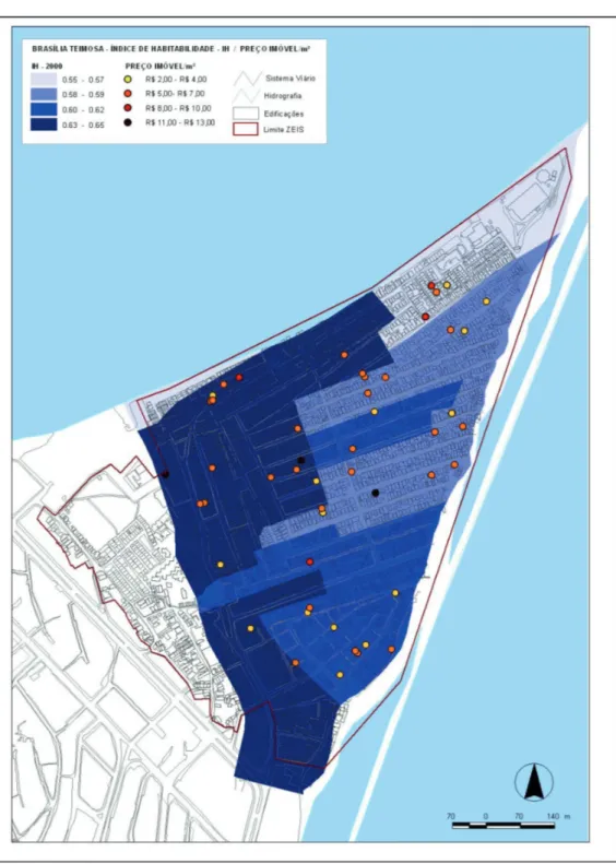
Figure 1: IH 2000 x Rental Cost / m2
Figure 2: ID 2010 x Rental Cost / m2
The habitability values of census tracts are shown in different shades of blue. The darker the shade, the higher the habitability condition. The sectors with very low habita-bility conditions are shown in light blue; sectors with regular habitahabita-bility conditions are shown in a medium shade of blue; and the sectors with the best habitability conditions are shown in dark blue.
Although it was made from the census data of 2000, the analysis presents some important results. According to them, it can be deduced that, in general, the habitability conditions of Brasília Teimosa are closely related to the proximity of the sectors to the formal environment, as well as the sea coasts and river banks. On the one hand, it is possible to verify that two sectors located on the river banks have the worst habitability conditions of the settlement. On the other hand, the sectors with the largest perimeter of contact with the formal environment have the best habitability conditions of the settlement.
An intermediate situation can be observed in the sectors located on the seacoast. In general, the sectors located exclusively on the seacoast have better habitability conditions than the sectors of riverbanks. Among the first, the nearest sectors to the formal envi-ronmrent have even better conditions. Although they do not come into direct contact with the formal environment, neither with the sea coasts nor river banks, some sectors are grouped with each other and most of them have the best habitability conditions of the settlement.
While it was not possible to make, properly speaking, a comparative analysis be-cause socioeconomic characteristics were not considered, the 2010 ID enables us to make some inferences. Whereas the figure above is a summary of the features related with the physical and environmental conditions by census tracts, it is possible to state that those sectors located in the central areas and which present a larger concentration of surveyed rental households have better results with regard to infrastructural issues(water supply, sanitary sewer, collection and disposal of solid waste, household typology and occupation conditions). This result differs from that presented by the IH 2000, whose best results were obtained by the nearest areas to the formal environment. Probably, this situation was the result of urban interventions in the location, especially in its seashores, with the withdrawal of palafittes.
Real estate rental market and environmental degradation
Although cities constitute the location where the environmental impacts of anthropic action are more strongly felt, only in the 1990s, the environmental issue was incorporated into the urban planning agenda. Only more recently, authors whose object of study is the “urban question” have tried to produce theoretical and methodological reflections in order to apprehend the interface between urban and environmental issues. From there, various concepts originated from related disciplinary fields which address environmental issues were incorporated into the “urban issue” and one of them was the concept of environmental impact. In addressing urban environmental impacts, Coelho (2001) presents a dual challenge. The first one involves to the problematization of rea-lity and the construction of a research object. The second one concerns the articulation between ecological (biophysical-chemical) and social processes and degradation of the urban environment. In this sense, to achieve this purpose, it was taken as a starting point the problematization of the expansion of the MIAP in the study area: Brasília Teimosa.
With regard to the recent dynamics of the occupation process, the above-mentioned research clearly showed that the informal real estate market, especially the real estate rental, occasioned changes in land occupation, which probably would be also contributing to environmental degradation. From the data obtained through the survey conducted in 2008/2009, it was possible to identify an increase of 58.27% the number of rented households, i.e., in 3 years the amount increased from 139 to 220. This increase is also identified when analyzing the data of the last three censuses, as shown in Table 3.
Table 3: Evolution of the Number of Permanent Private Households (PPH) and Rented (RPPH)
Analyzing the evolution of data on the Permanent Private Households (PPH) vii and the Rented Permanent Private Household (RPPH)viii in the last two decades, the importance of the rental market becomes even more evident. In the last decade, the per-centage of rented houses on the total number of households for residence nearly doubled: while the Censuses of 1991 and 2000, the percentage of rented households accounted for 10.95% and 12.61% respectively in 2010, after the urbanization of the sea coast and other improvements undertaken in the locality, it was already 22.38%.
Comparing the data of Brasília Teimosa with the data of Recife as a whole, it is noteworthy that this increase in the 1991-2010 period was much higher than of the city, which caused, in 2010, the ratio between RPPH and PPH were virtually the same of the city.
The dynamics of this market can also be evidenced by the analysis of building typologies destined to rent and identified in the 2008/2009 surveyix. The identification of these typologies was made from the analysis of the dynamics of constructive densi-fication process, considering both its horizontal and vertical expansion, as well as the relationship of this process with the privatization of public spaces, which causes changes in the accessibility conditions.
If, on the one hand, to address the interface between urban and environmental issues represents a challenge, on the other hand, it is known that urban planning has an essential role in ensuring the urban environmental quality of our cities through urban planning and control. Therefore, it highlights the definition of urban parameters, i.e., the definition of criteria for measuring the minimum needed for social reproduction. In this sense, Acioly and Davidson (1998) state that the density is one of the most important in-dicators and parameters of urban design to be used in the planning and management of human settlements.
In order to advance in the construction of tools to evaluate how the expansion of MIAP has contributed to environmental degradation in these areas, Anjos (2013) proposes to define indicators of urban environmental dimension from urban parameters which regulate the land occupation, namely: (i) Occupation rate - surface percentage of the lot occupied by the building; (ii) Building density - ratio between the building area and its surface; and (iii) Vegetation cover - area percentage of the vegetation cover.
The above-mentioned calculation of the indicators of urban environmental dimension was possible from primary data collected from the aforementioned field rese-arch, and secondary data, obtained from the spatiotemporal analysis, specifically from the vectorization process of aerial images through geoprocessing software in two stages defined in terms of the instruments used: the Unibase, aerial picture of 1997 and the Ortofotocarta of 2007.
three blocks, an important role of cohabitation (rented and owned). From the buildings exclusively for residential use, 41.96% refers to cohabitation. Although it is not possible to establish a direct relationship, the cohabitation percentage coincides with the same of rented houses which are located in the same census tract (41.73%).
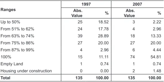
Ranges
1997 2007
Abs.
Value %
Abs.
Value %
Up to 50% 25 18.52 3 2.22
From 51% to 62% 24 17.78 4 2.96
From 63% to 74% 39 28.89 18 13.33
From 75% to 86% 27 20.00 27 20.00
From 87% to 99% 4 2.96 6 4.44
100% 15 11.11 74 54.81
Empty Land 1 0.74 1 0.74
Housing under construction 0 0.00 2 1.48
Total 135 100.00 135 100.00
Source: Unibase, 1997; Ortofotocarta 2007. Anjos, 2013.
Unlike 1997, in 2007 it is observed a significant reduction of households that are inserted into the first two ranges. According to Table 4, they decrease from 36.30% to 5.18%. In contrast, the lots with full occupation increase from 11.11% to 54.81%. Al-though one cannot completely attribute this phenomenon to the MIAP, it is indisputable that this market played an important role since, as seen above, the percentage of coha-biting households (41.96%) and rental homes (41.73%) presented quite approximate values. Another strong evidence: it is possible to perceive that the households which started to occupy the whole lot in 2007, in the vast majority, correspond to those iden-tified as cohabitation.
To address the constructive Density, firstly it is necessary to focus on the number of buildings floors. Such analysis is also based on the photographic record (2013). The buildings up to 1 floor represent 38.52%; with two floors 40.00%; and with 3 to 4 19.26% to the total building in those blocks (Table 5). It can be roughly said that these blocks have a horizontal spatial structure. After all, 78.52% of the buildings have up to two floors. It can also be assessed that all the blocks still have a high potential to the verticalization to 3 and 4 floors.
Table 4: Occupation Rate
Table 5: Number of floors in 2013
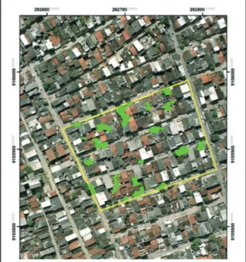
Brasília Teimosa, Census Tract 261160605230373
Ranges 2007
Abs. Value %
1 floor 52 38.52
2 floors 54 40.00
3 floors 25 18.52
4 floors 1 0.74
Empty land 1 0.74
Housing under construction 2 1.48
Total 135 100.00
Source: Anjos, 2013.
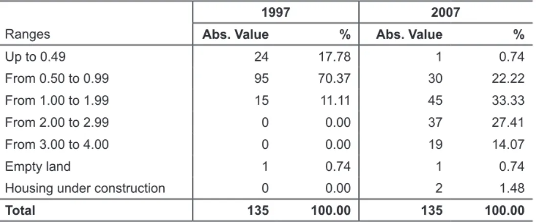
Such process of vertical integration cannot be analyzed separately from the lot occupation, which necessarily leads to the building density. For this exercise, it was as-sumed as a fact that in 1997, that is, previously to the period analyzed (1997-2007), the building had only one floor. The purpose of this exercise is to observe the impact of the vertical and horizontal densification process.
In the same way that the analysis on the Occupation rate, ranges were defined (Table 6). In 1997, with the exception of lots located in Arabaiana Street - whose pre-dominant usage is trade and services - 88.15% of the lots have building densities lower than 1. In 2007, this range represents only 22.96%. On the same year, (i) the densities located in the range from 1 to 1.99 had a 33.33% and (ii) the densities above this range corresponded to 4 1, 48% of the total of lots.
Table 6: Building Density
Brasília Teimosa, Census Tract 261160605230373
1997 2007
Ranges Abs. Value % Abs. Value %
Up to 0.49 24 17.78 1 0.74
From 0.50 to 0.99 95 70.37 30 22.22
From 1.00 to 1.99 15 11.11 45 33.33
From 2.00 to 2.99 0 0.00 37 27.41
From 3.00 to 4.00 0 0.00 19 14.07
Empty land 1 0.74 1 0.74
Housing under construction 0 0.00 2 1.48
Total 135 100.00 135 100.00
Regarding the indicator on the vegetation cover, it was measured by the ratio between the vegetation cover area (obtained from vectorization process with the aid of geoprocessing software) and the area occupied by buildings. Although it was not possible to perform a temporal analysis, due to the lack of image quality of 1997, the result for 2007 (Figure 5) leads to important considerations about this aspect.
Figure 5: Vegetation Cover in 2007 Brasília Teimosa, census Tract 261160605230373
Source: Ortofotocarta, 2007. Anjos, 2013.
The analyzed census tract has an area of 18,540 m 2 and 646 inhabitants. In exchange, the vegetation cover represent 1,669 m 2 . This means that the vegetation cover accounts for only 9.00% of the total area, being 2.58 m 2 of vegetation cover/ inhabitant.
public green areas can fulfill their essential functions and contribute to the develop-ment of human activities.
In the case analyzed, it can be seen that for both parameters the value found is lower. By extending the analysis to the surrounding of studied census tract, it is perceived that the situation persists in the absence of green spaces and open spaces that could serve as environmental element to enliven the area.
The isolated analysis of these new indicators does not reveal the degree of compro-mised of the quality of the urban environment (natural and built). However, when the results of all these indicators are observed, it can be said that various related processes occur simultaneously. In other words, there is a progressive representativeness of hou-seholds with high occupation of the lot, intense building density and hence progressive reduction of vegetation cover.
However, examination of the census tract, in the light of the new proposed indica-tors, showed another reality: despite improvements as referred, there was degradation in their environmental conditions. Exactly in this sector was identified a significant dyna-mics of the real estate rental market and the found evidence indicate that it contributed greatly to this degradation.
Knowing that these processes do not occur exclusively on the basis of the rental market (it is also possible to identify the expansion of buildings and the construction of homes in lots for housing to relatives and non-relatives), it is clear that the increase in the supply of homes for rent in Brasília Teimosa contributes to a series of transformations in its urban and environmental structures, which has taken place without proper planning and control by the responsible bodies. This process probably has caused in the medium- and long-term impacts on the area and its surroundings.
Understanding the urban environmental impacts as a process in constant motion, product and producer of new impacts, and recognizing the inadequacy on establishing rigid cause and effect relationships, it can be identified, however, some more significant processes that have contributed to the transformations in urban and environmental structures in Brasília Teimosa.
One of them refers to the fact that important aspects to ensuring environmental quality have been consistently neglected by the interventions, such as the creation of green and open spaces, which have an essential role in mitigation of bioclimatic conditions as well as in urban drainage. Besides that, the progressive densification, both horizontal and vertical, identified from data on the occupation of the whole lot, has contributed to other aspects such as the elimination of vegetation cover, soil sealing and the occupation of open public spaces which are equally important.
Final Considerations
As in most of Brazilian urban centers, it is a fact the significant number of settle-ments excluded from the regulatory framework and from the formal financial systems. They are multiplied in fragile land or in areas not amenable to urbanization such as steep slopes and flood areas, besides being vast fringes of peripheral expansion into rural areas, eternally unprovided with infrastructure, equipment and services which characterize the urbanity (peri-urban areas) (ROLNIK et al., 2006). Brasília Teimosa it is not the exception.
The incorporation of environmental dimension to urban problems constitutes a very fundamental aspect, since the process of urbanization, common to most of the large cities, causes perverse effects not only on the community directly involved, but on the city as a whole, condemning it to an unsustainable pattern, from the environmental and economic standpoint, since it imposes environmental losses and negative externalities on the whole city, very difficult to be recovered.
A huge challenge is imposed on society and public power in an attempt to make compatible two constitutional rights: on the one hand, it is expressed in Article 6, included among the social rights, the right to housing; on the other, the Article 225 states that everyone has the right to an ecologically balanced environment, good of common use and essential to a healthy quality of life, imposing on the public power and collectivity the duty to defend it and preserve it for present and future generations.
The reduction of land occupation and the absence of public policies to combat the increasing housing deficit have guaranteed to the rental market the position of important form of access to housing in many of the urban centers. The production of offer to meet the growing demand of that market contributes to the aggravation of environmental issues and unsustainable processes of space production by the manner in which this process takes place, without planning and control by the responsible bodies, as well as the knowledge of the carrying capacity of urban and environmental structures. In this context, the knowledge of the rules that govern this market can contribute by providing fundamental clues to the search of strategies which aim to make compatible the above--mentioned constitutional rights.
In this sense, the validation of the new indicators proposed in Brasília Teimosa showed that there was an environmental degradation, unlike the improvements in in-frastructure evidenced by the ID analysis. This is because the result of the proposed set of indicators points out that that recent dynamics of occupation, represented by MIAP, is compromising and tends to further compromise, the environmental quality of poor areas. From the analysis of a census tract of Brasília Teimosa, considering the 1997-2007 period, it was possible to demonstrate that the occupation rate increased from 67.49% to 87.11% and the building density increased from 0.67 to 1, 60 (values relating to the average for the three analyzed blocks). As a result of these two processes, there was a significant reduction in vegetation cover.
From the produced panorama and the constitution of struggling movements for housing and access to land, both by way of regulation as the path of urbanization, it is essential to compatibilize the improvement of habitability conditions, which ultimately has invigorated the informal rental market, and the control of environmental degradation.
Thus the urban planning has strategic importance, since it has the duty to ensu-ring better habitability conditions by improving infrastructure and urban services and, at the same time, by minimizing energetic degradation and decelerating the irreversible trajectory of the environmental deterioration of our cities.
Notes
i The research received financial support, in its different phases, from FINEP and CNPq, and lead author with doctoral bursary granted by the Fundação de Amparo à Ciência e Tecnologia de Pernambuco - Facepe (Foundation for Science and Technology of Pernambuco).
ii This new field research developed by Gemfi has selected Brasília Teimosa, Mustardinha (location that also presented a dynamic rental market) and Tabatinga (unconsolidated area in the municipality of Camaragibe, in the peri-urban area of RMR) as study areas. In Brasília Teimosa, the research was developed between 2008 and 2009, and in Mustardinha and Tabatinga, between 2009 and 2010.
iii Analysis presented at the XIII National Meeting of the ANPUR held in Florianópolis in May 2009, and in the Article called Real estate rental market in poor areas: operating standards and sense of informality (LACERDA et al., 2010). iv According Blachere (1978), the concept of habitability expresses the human needs as a living, intelligent and social being. Thus, encompasses the physiological, psychological and sociological needs in relation to the building and in particular to the household.
v Dias, Borja and Moraes (2004) define the environmental health “as all the material and social conditions necessary to achieve a state conducive to health, which are influenced by culture” (DIAS; BORJA; MORAES, 2004, p. 84). vi The census tract corresponds to the minimum unit of data aggregation established by the IBGE. These sectors are associated with attributes that describe the physical characteristics of a number of households and socioeconomic characteristics of a set of householders.
vii Permanent private households are those whose relationship between the occupants was dictated by kinship ties, domestic dependence or living standards, built with the purpose of serving for housing to one or more people (IBGE, 2003; IBGE, 2011).
viii Permanent Private Households, in turn, are classified according to occupation condition as: (i) Property already paid; (ii) Property under acquisition; (iii) Rented; (iv) Assigned by the employer; (v) Assigned in another way; and (vi) Another condition (IBGE, 2003; IBGE, 2011).
ix The classification of rental typologies developed for the research was presented by the first time in the paper presented at the XIII National Meeting of the ANPUR held in Florianópolis in May 2009 (LACERDA et al., 2009).
References
ABRAMO, P. A teoria econômica da favela: quatro notas sobre a localização residencial dos pobres e o mercado imobiliário informal. In: ABRAMO, P. (Org.). A cidade da informalidade: Desafio das cidades latino-americanas. Rio de Janeiro, Livraria Sette Letras/FAPERJ, 2003.
ACIOLY, C.; DAVIDSON, F. Densidade urbana: um instrumento de planejamento e gestão urbana. Rio de Janeiro: Mauad, 1998.
ANJOS, K. L. Mercado imobiliário de aluguel em áreas pobres e as transformações urbanas e ambientais. 2013. 276 f. Thesis (Doctorate in Urban Development) – Department of Architecture and Urbanism, Federal University of Pernambuco, Recife, 2013.
BALTRUSIS, N. Mercado imobiliário informal em favelas e o processo de estruturação da cidade: um estudo sobre a comercialização de imóveis em favelas na Região Metropolitana de São Paulo. 2005. 231 f. Thesis (Doutorate) – Department of Architecture and Urbanism, Federal University of São Paulo, São Paulo, 2005.
BARROS FILHO, M. N. M. As múltiplas escalas da diversidade intra-urbana: uma análise de padrões socioespaciais no Recife (Brasil). 2006. 296 f. Thesis (Doutorate in Urban Development) – Department of Architecture and Urbanism, Federal University of Pernambuco, Recife, 2006.
BLACHERE, G. Saber construir: habitabilidad, durabilidad, economía de los edificios. Barcelona: Técnicos Asociados, 1978.
CAVALHEIRO, F., DEL PICCCHIA, P. C. D. Áreas verdes: conceitos, objetivos e diretrizes para o planejamento. In: ENCONTRO NACIONAL SOBRE ARBORIZAÇÃO URBANA, 4, 1992, Vitória. Anais... Vitória, 1992. p. 29-38.
COELHO, M. C. N. Impactos ambientais em áreas urbanas: teorias, conceitos e métodos de pesquisa. In: GUERRA, A. J. T.; CUNHA, S. B. (Org.). Impactos ambientais urbanos no Brasil. Rio de Janeiro: Bertrand Brasil, 2001. p. 19-45.
WORLD COMMISSION ON ENVIRONMENT AND DEVELOPMENT. Our common future. 1. ed. Rio de Janeiro: Editora FGV, 1988.
DAVIS, M. Planeta favela. São Paulo: Boitempo, 2006.
DIAS, M. C.; BORJA, P. C.; MORAES, L. R. S. Índice de salubridade ambiental em áreas de ocupação espontâneas: um estudo em Salvador - Bahia. Engenharia sanitária e ambiental; 9(1): p. 82-92, jan.-mar. 2004. Ilus., tab. Available at: <http://www.bvsde. paho.org/bvsacd/abes/v9n1/p82a92.pdf>. Retrieved on: 27 set. 2007.
IBGE. Censo Demográfico 2000: Agregado por Setores Censitários dos Resultados do Universo. Documentação do Arquivo. 2. ed. Rio de Janeiro: IBGE, 2003.
______. Base de informações do Censo Demográfico 2010: Resultados do Universo por setor censitário. Documentação do Arquivo. Rio de Janeiro: IBGE, 2011.
KOWARICK, L. A espoliação urbana. São Paulo: Paz e Terra, 1979.
LACERDA, N.; MELO, J. M. Mercado imobiliário de habitação na Região Metropolitana do Recife. In: Abramo, Pedro. (Org.). Favela e mercado informal: a nova porta de entrada dos pobres nas cidades brasileiras. Porto Alegre: Antac, 2009, v. 10, p. 112-138.
LACERDA, N.; SILVA, A. P.; CRUZ, D. O. M.; ANJOS, K. L. Mercado imobiliário de aluguel em áreas pobres: normas de funcionamento e sentidos da informalidade In: LEAL, Suely; LACERDA, Norma. (Org.). Novos padrões de acumulação urbana na produção do habitat: olhares cruzados Brasil - França. Recife: Editora Universitária UFPE, 2010, p. 241-269.
LACERDA, N. Mercado imobiliário de aluguel em áreas pobres e teoria das convenções. Recife: Centro de Estudos Avançados da Conservação Integrada, 2011.
MARICATO, E. A produção capitalista da casa (e da cidade) no Brasil industrial. São Paulo: Alfa-Ômega, 1979.
MEDAUAR, O. (Org.). Constituição Federal, coletânea de legislação de direito ambiental. São Paulo: Editora Revista dos Tribunais, 2002.
PASTERNAK, S. Habitação e adensamento urbano. In: REUNIÃO ANUAL DA SBPC, 41, 1989, São Paulo. Ciência e Cultura, São Paulo, v. 41. p. 22-22, 1989.
ROLNIK, R. (et al.). Regularização fundiária de assentamentos informais urbanos. Belo Horizonte: PUC Minas Virtual, 2006.
Submitted on: 29/12/2012 Accepted on: 14/10/2014
Abstract: Recent researches have revealed the importance of the rental market in the poor areas of large Brazilian cities for the access to housing of the low-income populations. The dynamism of this market in the Metropolitan Region of Recife was highlighted by the research on the functioning of the housing market in poor areas (2005 - 2012). Based on the results, some questions were made with respect to the changes in the urban and environmental structures from the dynamism of this market and if these changes would not be contributing to the environmental degradation of these settlements. Therefore, this paper aims to analyze the urban transformations, generated by the mentioned market and its environmental implications, having as object of study Brazilia Teimosa, where the housing market showed greater dynamism when compared to other localities studied.
Keywords: Rental housing market; Poor areas; Urban environmental impacts.
Resumo: Pesquisas recentes têm revelado a importância do mercado de aluguel nas áreas pobres das grandes cidades brasileiras para o acesso à moradia das populações de baixa renda. O dinamismo desse mercado na Região Metropolitana do Recife (RMR) foi ressaltado pela pesquisa sobre o Funcionamento do mercado de habitações em áreas pobres, desenvolvida entre os anos de 2005 e 2012, no âmbito do Grupo de Estudos sobre o Mercado Fundiário e Imobiliário (Gemfi) da Universidade Federal de Pernambuco (UFPE). Com base nos re-sultados encontrados, alguns questionamentos foram feitos acerca das transformações nas estruturas urbanas e ambientais a partir do dinamismo desse mercado, além de se cogitar se essas transformações não estariam contribuindo para a degradação ambiental desses as-sentamentos. Sendo assim, o presente texto tem como objetivo analisar as transformações urbanas, geradas a partir domencionado mercado, e suas implicações socioambientais, tendo como objeto de estudo Brasília Teimosa, localidade onde o mercado imobiliário apresentou um maior dinamismo dentre aquelas estudadas.
Palavras-chave: Mercado imobiliário de aluguel; Áreas pobres; Impactos ambientais
urbanos.
URBAN AND ENVIRONMENTAL TRANSFORMATIONS IN POOR AREAS OF
THE METROPOLITAN REGION OF RECIFE (BRAZIL)
Resumen: Investigaciones recientes pusieron de manifiesto la importancia del mercado de alquiler en las áreas pobres de las grandes ciudades brasileñas para el acceso a la vivienda de las poblaciones de bajos ingresos. El dinamismo de este mercado en la Región Metropoli-tana de Recife se puso de relieve en la investigación sobre el Funcionamiento del mercado de vivienda en áreas pobres (2005 - 2012). Con base en los resultados encontrados, se hicieron algunos cuestionamientos con respecto a las transformaciones en las estructuras urbanas y ambientales a partir del dinamismo de este mercado, y si dichas transformaciones no es-tarían contribuyendo a la degradación ambiental de estos asentamientos. Por lo tanto, este trabajo tiene como objetivo analizar las transformaciones urbanas, generadas a partir del mencionado mercado y sus implicaciones ambientales, teniendo como objeto de estudio a Brasília Teimosa, localidad en la cual el mercado inmobiliario presentó un mayor dinamismo en comparación con las otras localidades estudiadas.
Palabras clave: Mercado inmobiliario de alquiler; Areas pobres; Impactos ambientales