Morphometry and longitudinal profile of the river cobras sub-basin in
planning the location of underground dams
1Morfometria e perfil longitudinal da sub-bacia do rio das Cobras para locação de
barragens subterrâneas
Alexandre de Oliveira Lima2, Francisco Pinheiro Lima-Filho3, Nildo da Silva Dias4*, Anderson de Medeiros
Sousa5 and Marcia Regina Farias da Silva2
ABSTRACT - A study was carried out in the sub-basin of the River Cobras with the aim of evaluating the morphometric
characteristics and longitudinal profile of the river basin as a tool for planning the location of underground dams. Morphometric parameters - compactness coefficient, form factor, drainage density and circularity index - were determined. An equilibrium profile was also performed in order to understand the dynamics of erosion and disposition in the sub-basin under study. The results showed that the River Cobras sub-basin is strongly elongated, with low drainage density and high rates of runoff in alluvial areas. The equilibrium profile indicated that the middle course (18 km, stretch 2) of the sub-basin includes a first-order anomaly and is susceptible to erosive processes along this stretch. The lower course (10 km, stretch 3) also has a first order anomaly; however, with a tendency to favour the aggregation of sedimentary material (larger sedimentary bundle) coming from the middle course. The middle course of the sub-basin has potential for the construction of submersible underground dams; whereas in the lower course, the construction of submerged underground dams is recommended. The physical morphometric parameters should not be analysed in isolation, but together with other aspects of surface- and groundwater quality, the recharge area and the social or production demand on the sub-basin.
Key words: Water resource management. Hydrology. Strategies for coexisting with a semi-arid climate.
RESUMO - Um estudo na sub-bacia hidrográfica do rio das Cobras foi realizado com o objetivo de avaliar as características
morfométricas e o perfil longitudinal da bacia hidrográfica, como ferramenta de planejamento na locação de barragens subterrâneas. Os parâmetros morfométricos – coeficiente de compacidade, fator forma, densidade de drenagem e índice de circularidade - foram determinados. Também foi realizado o perfil de equilíbrio a fim de compreender a dinâmica de erosão e a disposição na sub-bacia estudada. Os resultados demonstraram que a sub-bacia do rio das Cobras possui forte caráter alongado, baixa densidade de drenagem e altas taxas de escoamento superficial para as áreas aluvionares. O perfil de equilíbrio indicou que o médio curso (18 km, trecho 2) da sub-bacia tem anomalia de primeira ordem com susceptibilidade a processos erosivos ao longo deste trecho. O segmento baixo curso (10 km, trecho 3) também possui anomalia de primeira ordem; porém, com tendência de agradação de material sedimentar (pacote sedimentar maior), advindo do médio curso. O médio curso da sub-bacia tem potencial para a construção de barragens subterrâneas submersíveis; já no baixo curso, recomenda-se a construção de barragens subterrâneas submersas. Os parâmetros morfométricos físicos não devem ser analisados isoladamente, mas integrados a outros aspectos de qualidade das águas superficiais e subterrâneas, área de recarga e demanda social ou produtiva da sub-bacia.
Palavras-chave: Gestão de recursos hídricos. Hidrologia. Estratégia de convivência com o semiárido.
DOI: 10.5935/1806-6690.20190066 *Author for correspondence
Received for publication 21/01/2017; approved on 04/06/2019
1Parte da Tese de Doutorado apresentada ao Programa de Pós-Graduação em Geodinâmica e Geofísica, Universidade Federal do Rio Grande do Norte/
UFRN
2Universidade do Estado do Rio Grande do Norte/UERN, Mossoró-RN, Brasil, [email protected] (ORCID ID 0000-0003-3756-5921),
[email protected] (ORCID ID 0000-0002-6685-598X)
3Universidade Federal do Rio Grande do Norte, Natal-RN, Brasil, [email protected] (ORCID ID 0000-0001-5657-5207) 4Universidade Federal Rural do Semi-Árido/UFERSA, Mossoró-RN, Brasil, [email protected] (ORCID ID 0000-0002-1276-5444)
5Instituto Federal de Educação, Ciência e Tecnologia da Paraíba/IFPB, Picuí-PB, Brasil, [email protected] (ORCID ID
INTRODUCTION
In recent years there has been a significant increase in the number of underground dams built in the Brazilian semi-arid region. These hydro-environmental works, funded by the Federal Government and implemented through partnerships with state governments or non-governmental organizations (LIMA et al., 2017), are designed to maximise the use of water from alluvial bodies and meet the suppressed water demands of rural populations, whether for domestic or agricultural purposes (LOPES et al., 2013; SENTHILKUMAR; ELANGO, 2011).
Underground dams can be constructed in temporary riverbeds of arid and semi-arid regions that develop on an impermeable substrate, such as rocks of the crystalline basement, preferably without the presence of fracture systems or expressive foliations (LIMA et al., 2013).
In various parts of the world, such as in Africa, Asia and South America, underground dams already exist. However, before the actual construction of underground dams, studies of the morphometry (OLIVEIRA et al., 2010; VILLELA; MATOS, 1975) and longitudinal profile of the basins are fundamental when the idea is the sustainable management of water resources, using the basins and sub-basins as a reference in territorial planning.
The morphometric characteristics of fluvial channels, such as circularity, compactness coefficient and drainage density, have a marked influence on the sustainable management of water usage, since they are predictive indicators of the degree of vulnerability of the basin (flooding and erodibility) (COUTINHO et al., 2011; GUEDES et al., 2015; LIMA; CORRÊA; NASCIMENTO, 2011).
The longitudinal profile or equilibrium profile is an ideal hypothetical condition in which rivers are in dynamic equilibrium in relation to the totals eroded and transported. In practice, in all river basins there are stretches which are susceptible to erosion, and others with the occurrence of marked sedimentation helping to increase the sedimentary bundle. This condition of equilibrium can be altered naturally (tectonic movements) or by anthropogenic action (construction of surface dams).
Investigating the morphometry of river basins is essential for understanding the spatial and temporal dynamics of different geomorphological forms (LATIEF
et al., 2015). A survey of the equilibrium profile is a
necessary procedure in defining stretches of a river in which a greater accumulation of sediment can occur, and which are consequently suitable for the installation of an
underground dam. Although such a study is important, there are no records that show this type of preliminary survey having been conducted for the installation of underground dams, despite this information being useful for environmental planning and water resource management.
As such, a study in the sub-basin of the River Cobras was carried out with the aim of evaluating the use, morphometric characteristics and longitudinal profile of the river basin as a tool for planning the location of underground dams.
MATERIAL AND METHODS
Characterisation of the study area
The area of influence of the River Cobras covers 159.13 km², including part of the municipalities of Parelhas, Carnaúba dos Dantas and Jardim do Seridó (Figure 1). The sub-basin is wholly inserted in the area of Seridó, in the semi-arid region of the state of Rio Grande do Norte, Brazil (RN).
The area under study also includes the Desertification Nucleus of Seridó (NUDES), one of the four nuclei in northeastern Brazil classified by the Ministry of the Environment. The nucleus covers an area of 2,341 km² (18.06% of the region), home to 244,000 inhabitants (84.21% of the population). It has a population density of 104.23 hab km-2 (SÁ; ANGELOTI,
2009).
The region has a mean annual precipitation of 733.6 mm with irregular distribution. The annual water deficit is of the order of 1,169.9 mm, which corresponds to approximately 1.6 times the annual precipitation, strongly concentrated from August to December (more than 72% of the annual water deficit) (SANTANA et al., 2006).
In geological terms, the sub-basin is composed of rocks of the crystalline basement, the Seridó Belt, located in the extreme northeast of Borborema Province. It is composed of metavulcanic rocks from shale-green facies to amphibolite facies of the Seridó Group (JARDIM DE SÁ et al., 1999).
Determination of physical morphometric parameters
Using the methods proposed by Cardoso et al. (2006), the physical characteristics of the river basin were determined: compactness coefficient, form factor, circularity index, drainage density and altitude order of the watercourses.
Figure 1 - Area with the incidence of units of geological occurrence in the River Cobras sub-basin, RN
The compactness coefficient (KC) relates the shape of the basin to a circle, and comprises the relationship between the perimeter of the basin and the circumference of a circle with an area equal to that of the basin, as per Equation 1:
KC = 0.28P/√A (1)
where:
P = perimeter of the basin, in km; A = area of the basin in km².
The form factor (F) relates the shape of the basin to a rectangle, corresponding to the ratio between mean width and the axial length of the basin. To determination the form factor, the longest length is obtained from the mouth to the furthest head of the basin (Equation 2).
F = A/L² (2)
where:
A = drainage area in m2;
L = length of axis of the basin in m.
The circularity index (CI) also tends toward one as it approaches a circular shape, and decreases as the shape becomes elongated, estimated by Equation 3:
CI = 12.57 x A/P2 (3)
where:
A = drainage area in m²; P = perimeter in m.
The drainage density (Dd) is the degree of development of a drainage system. Although there is little information on drainage density (Dd) in river basins, this index is said to vary from 0.5 km.km-2 for basins with poor
drainage, to 3.5 km km-2 for exceptionally well-drained
basins (VILLELA; MATTOS, 1975).
Dd = L/A (4)
where:
L = total length of the water courses and Av = area of the basin.
Determination of the equilibrium profile
To determine the equilibrium profile, an altimetric survey was carried out using a Geodetic GPS (Hyper Lite +, TOPCON). Twenty points were collected along the main river between the source and the mouth, a length of 36.51 km. Based on this information, it was possible to identify inflection points along the entire length of the main river. Once the drainage gradient was determined, the length of the river was subdivided into 3 sections, called the upper course (points 1 to 6), middle course (7 to 14) and lower course (15 to 20) (Figure 2).
To define anomalous stretches along the main river, the slope to extension ratio (SER ratio) per section of interest (SERsection) and also for the total length (SERtotal) of the fluvial channel were calculated as per Equations 5 and 6.
SERsection = DH/DL x L (5) SERtotal = DH/Log L (6)
where:
DH = altimetric difference between two selected points of
the watercourse;
DL = length of the section under analysis;
L = total length of the channel, from the source to the end
point of the section where the SER index was calculated. This analysis allows a more accurate view of the equilibrium dynamics for sections of the river of specific interest, for example, stretches in which erosion and deposition are occurring throughout the area under study. An SERsection to SERtotal ratio greater than 2 is considered anomalous. There are two categories of anomalies, known as second-order when the indices obtained are within the thresholds 2 to 10, and first-order anomalies, when the values are equal to or greater than 10.
Digital Terrain Model (DTM)
The slope of a terrain is expressed as the variation in altitude between two points of the terrain in relation
Figure 2 - Acquisition points with the Geodetic GPS from the source to the mouth, for the purpose of preparing the equilibrium profile
of the River Cobras, RN
to the distance that separates them (TONELLO et al., 2006). The classes of slope were hierarchical, with distinct intervals ranging from flat relief to extremely mountainous. The DTM was produced using the digitised contour lines of the IBGE, on a scale of 1:500,000 at an interval of 40 m. The data were then transferred to the ARCVIEW 9.3 software in shapefile format (SHP).
RESULTS AND DISCUSSION
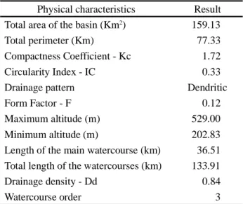
The values of the physical morphometric parameters found for the sub-basin of the River Cobras are shown in Table 1.
In the River Cobras sub-basin, high values were found for the compactness coefficient (Kc = 1.72) and low values for the form factor (F = 0.12). It can be inferred that Kc is 72% greater than the reference value (Kc = 1). Studies by Tonello et al. (2006) and Cardoso et al. (2006) showed that values obtained for Kc different to 1 (between 1.57 and 1.56), and low values for F (between 0.409 and 0.33), indicate an elongated geometry for the basins under study.
Basins which are more elongated reduce the likelihood of intense rains occurring simultaneously throughout the area of the sub-basin, in which case there are no large volumes of water, facilitating rapid drainage of the rainfall and reducing the residence time of the water in the area of the sub-basin (LATIEF et al., 2015; OLIVEIRA et al., 2010).
Table 1 - Physical Characteristics of the River Cobras
sub-basin, RN
Physical characteristics Result
Total area of the basin (Km2) 159.13
Total perimeter (Km) 77.33
Compactness Coefficient - Kc 1.72
Circularity Index - IC 0.33
Drainage pattern Dendritic
Form Factor - F 0.12
Maximum altitude (m) 529.00
Minimum altitude (m) 202.83
Length of the main watercourse (km) 36.51 Total length of the watercourses (km) 133.91
Drainage density - Dd 0.84
Watercourse order 3
The high value for Kc and the low value for F are associated with the predominance of shallow soils and rocky outcrops from the crystalline basement. Consequently, there is a strong tendency for high rates of surface runoff and rapid draining of the precipitation. This situation indicates the need for technological alternatives that would delay displacement of the surface and groundwater.
A group of dams exists on the surface in the region; as far as sub-surface use is concerned, the construction of underground dams is an alternative way of blocking the rapid displacement of precipitated water that reaches the alluvium via surface and underground runoff.
The low value for drainage density (0.84 km km2)
indicates poor drainage in the sub-basin of the River Cobras (VILELA; MATOS 1974). When analysing drainage between the upper, middle and lower courses, higher drainage density is found in the upper course (Figure 3), with a noticeable decrease for the middle and lower courses of the river. There is therefore greater potential for the construction of underground dams in the upper course when this criterion is considered in isolation. However, to do so, a more careful evaluation is necessary, considering other conditions, such as the thickness of the sedimentary bundle, shortening of rocky outcrops, water quality, etc.
For the order of the watercourses in the sub-basin, it can be seen that, within this framework, a basin of order 3 was obtained (Figure 3). When analysing the geomorphology of the area of the micro basin, it is found that a slope of up to 2.66 degrees predominates over 67.96% of the area, flat relief, corresponding to the region that extends from the middle to the lower course (mouth of the River Cobras and start of the River Seridó). The slope of 2.67 to 25 degrees corresponds to 31.8% of the area, including most of the middle course until near the dividers of the sub-basin.
The remainder of the area, around 0.25%, has a slope of over 25 and up to 45 degrees, and corresponds to the strongly undulating area. These, of course, correspond to the tops of the water dividers in the sub-basin in question (Figure 4). A strong correlation can be seen between the order of the courses and the predominant terrain. In section 1 of the basin (upper course), a higher drainage density predominates due to the larger gradient, causing higher runoff rates and lower rates of infiltration (Figure 4).
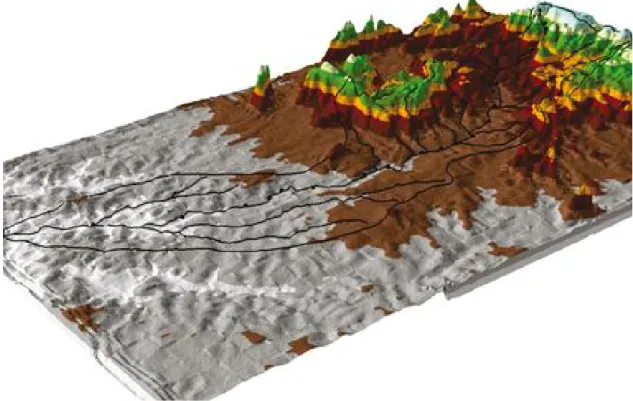
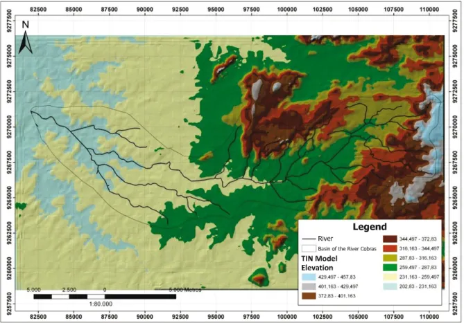
The variation in existing elevations throughout the sub-basin clearly shows that the highest elevations are concentrated in an area that includes the source to the middle part of the micro basin (Figure 5). For Calil et al. (2012), topography exerts a greater influence on water and sediment flow in river basins, and its parameters
Figure 3 - Order of the water courses in the area of influence of the River Cobras sub-basin, RN
define the structure of the drainage network and its tributaries.
Longitudinal Profile of the River Cobras
The longitudinal profile or equilibrium profile of the river was obtained (Figure 6) from the altimetric data of 20 points collected along the main river (River Cobras). The difference in level is 326.17 m, corresponding to the difference in altitude between point 1 (height 529.00) - the source, and point 23 (202.83) - the mouth of the river. From this information, and from the length of the main river, the total slope and extension ratio (SER) was determined as being equal to 31.51.
In the overall analysis, the River Cobras has three mismatched sections, two of elevation (predominance of erosive processes), and one of subsidence (predominance of sediment deposition). To analyse the SER of this section, an evaluation was carried out between points 6 and 14 (middle course). This procedure was adopted as per Etchebehere et al. (2006), where areas of significant slope are ignored in order to avoid distortions in the angle of inclination of the line, which would make analysis difficult. As such, in section 2, which goes from point 6
to point 14 (with a length of 18 km), the SERsection to SERtotal ratio between these points was 3.20, constituting a first-order anomalous section (value between 2 and 6) or imbalance. There is a tendency in this section for the river to seek equilibrium, eroding the part which is above the trend line of the logarithmic expression.
The longitudinal profile of a river is closely related to the relief, as it corresponds to the difference in altitude between the source and the confluence with another river.
Figure 5 - TIN elevation model of the terrain in the area of influence of the River Cobras sub-basin, RN
Figure 6 - Slope to extension ratio (SER) and equilibrium profile
For Scherer (2008), the longitudinal profile of a river is the expression of its slope or gradient, represented by the ratio of altimetry to length for several points located between the source and the mouth. The slope of the equilibrium profile is a function of the net discharge of the river and of the transported sediment load. This balance is controlled by several factors both internal and external to the basin, such as relief, tectonics, climate, rock resistance, ground cover, and land use and management.
Thus, the more balanced the watercourse, the greater the adjustment of the logarithmic function of its longitudinal profile. The balance of the water course refers to the stability of its hydraulic behaviour, preventing erosion and aggregation of the thalweg, with only the passage of sediment discharge. On the other hand, curves with less concavity in the profile or abrupt changes, indicate a condition of imbalance (GUEDES et al., 2015).
In section 3 (lower course), a stretch of 10 km between points 15 and 20, the SER was 4.13; a first-order anomaly occurred, with a tendency for the aggregation of eroded material from the previous section; because of this tendency for sediment accumulation, there is also a greater capacity for groundwater to accumulate over time in this section.
In the River Cobras, anomalies of more modest amplitudes can be seen when the SER values (SER equal to 3.20 and 4.13 for stretches 2 and 3 respectively) are compared with those reported by Melo, Douhi (2009) for the River Baiano, in the municipality of Assis Chateaubriand in the state of Paraná (SER ranging from 1.67 to 10) and by Martinez (2005) for the River Pirapó, in the north west of Paraná (SER = 6.9).
Important aspects that contribute to intensify erosive processes are the removal of natural vegetation, outcrops with a crystalline geological structure and shallow soils. As such, the slope and ground cover become important factors in the decision-making process for suitable management of the river basin. These factors influence the effective precipitation, the surface runoff and flow of water in the soil (CARDOSO et al., 2006; LATIEF et al., 2015). Also important in this context are the processes of environmental degradation related to erosion and the silting up of water courses.
Influence of physical characteristics and the longitudinal profile on the location of underground dams.
The existence of different methodologies for constructing underground dams allows expansion of the most effective management related to increases in the water supply for human and animal consumption, and food production (LIMA et al., 2013).
However, the method of constructing underground dams in the semi-arid region is subject to prior studies that include and integrate the various physical characteristics of the basin, such as longitudinal profile and morphometry. There may therefore be a perfect synergy between activation of the water potential and meeting the demand and the need for sustainable water use.
Drainage density, considered low in the area of the sub-basin under study, restricts the local population’s access to water, since rivers and streams are a promising alternative for water supply in the region. It is therefore necessary to guarantee the potential for water extraction in places where there is a possibility of the sustainable use of existing alluviums.
An analysis of drainage behaviour between the upper, middle and lower courses indicates higher drainage density in the upper course of the river (Figure 5), with a noticeable decrease in the middle and lower courses. When considering this criterion in isolation, there is greater potential for the construction of underground dams in the upper course. However, as density is associated with higher gradients, as seen in the Triangular Irregular Network (TIN) model of terrain elevation (Figure 5), it can be expected that sedimentary bundles in these areas will be smaller, with the prevalence of erosive processes; a fact which limits storage capacity.
In that case, it would be more feasible to construct models of submersible underground dams. To do this, methodologies are applied where there is a wall above ground, as proof of the gradual accumulation of sediment over time.
On the other hand, in the short term, this factor is not enough to prevent the construction of underground dams if there are no alternatives for supplying water to the families and communities living in the area. It is also important that other parameters, such as water hydrochemistry, be considered and analysed in an integrated way. These procedures are fundamental to the decision-making process on the viability of constructing underground dams in the stretch that corresponds to 50% of the total length of the sub-basin.
CONCLUSIONS
1. The use of morphometric parameters and the longitudinal profile of a river basin proved to be adequate as a tool in planning the construction of underground dams. However, it is recommended that these parameters be used in conjunction with other parameters, such as the physico-chemical quality of the water and soil throughout the basin;
2. Due to the elongated shape of the sub-basin of the River Cobras, it is less susceptible to flooding, with a strong tendency for rapid water runoff. This situation makes it necessary to construct underground dams as an alternative for increasing the residence time of the water in the basin; 3. The middle course of the River Cobras has a first-order
anomaly with a tendency for erosion, and is suitable for the construction of submersible underground dams; 4. The lower course of the River Cobras shows a tendency
towards the aggregation of eroded material from the middle course, and is suitable for the construction of submerged underground dams.
REFERENCES
CALIL, P. M. et al. Caracterização geomorfométrica e do uso do solo da Bacia Hidrográfica do Alto Meia Ponte, Goiás.
Revista Brasileira de Engenharia Agrícola e Ambiental,
v. 16, n. 4, p. 433-442, 2012.
CARDOSO, C. A. et al. Caracterização morfométrica da bacia hidrográfica do rio Debossan, Nova Friburgo, RJ. Revista
Árvore, v. 30, n. 2, p. 241-248, 2006.
COUTINHO, L. M. et al. Caracterização morfométrica da bacia hidrográfica do rio da Prata, Castelo, ES. Irriga, v. 16, n. 4, p. 369-381, 2011.
ETCHEBEHERE, M. L. C. et al. Detecção de prováveis deformações neotectônicas no vale do Rio do Peixe, região ocidental paulista mediante aplicação de índices RDE (Relação Declividade-Extensão) em segmentos de drenagem.
Geociências, v. 25, n. 3, p. 271-289, 2006.
GUEDES, I. C. et al. Indicações de deformações neotectônicas na bacia do Rio Pardo-SP através de análises de parâmetros fluviomorfométricos e de imagens SRTM. Geociências, v. 34, n. 3, p. 364-380, 2015.
JARDIM DE SÁ, E. F. et al. Brasiliano syntectonic alkaline granite emplaced in a strike slip/extensional setting (eastern Seridó Belt, NE Brazil). Anais da Academia Brasileira de
Ciências, v. 71, n. 1, p. 17-27, 1999.
LATIEF, S. U. et al. Morphometric analysis of East Liddar Watershed, Northwestern Himalayas. International Journal of
Geo Science and Geo Informatics, v. 2, n. 1, p. 1-11, 2015.
LIMA, A. O. et al. Barragens subterrâneas no semiárido brasileiro: análise histórica e metodologia de construção. Irriga, v. 18, n. 2, p. 200-211, 2013.
LIMA, A. O. et al. Mechanisms controlling surface water quality in the Cobras river sub-basin, northeastern Brazil. Revista
Caatinga, v. 30, n. 1, p. 181-189, 2017.
LIMA, C. S.; CORRÊA, A. C. B.; NASCIMENTO, N. R. Analysis of the morphometric parameters of the Rio Preto basin, Serra do espinhaço (Minas Gerais, Brazil). Geociências, v. 30, n. 1, p. 105-112, 2011.
LOPES, H. L. et al. Mapeamento de áreas aluvionares no semiárido brasileiro por meio de dados colaterais e imagens orbitais. Revista Brasileira de Engenharia Agrícola e
Ambiental, v. 17, n .7, p. 763-769, 2013.
MARTINEZ, M. Aplicação de parâmetros morfométricos
de drenagem na bacia do Rio Pirapó: o perfil longitudinal.
2005. 96 f. Dissertação (Mestrado em Geografia) -Universidade Estadual de Maringá, Maringá, 2005.
MELO, O. A. G.; DOUHI, N. Análise do perfil longitudinal do rio Baiano Assis Chateaubriand/PR. Revista Científica
Multidisciplinar, v. 2, n. 1, p. 123-125, 2009.
OLIVEIRA, P. T. S. et al. Caracterização morfométrica de bacias hidrográficas através de dados SRTM. Revista Brasileira de
Engenharia Agrícola e Ambiental, v. 14, n. 8, p. 819-825,
2010.
SÁ, I. B; ANGELOTI, F. Degradação ambiental e desertificação no semiárido brasileiro. In: ANGELOTI, F. et al. Mudanças
climáticas e desertificação no semiárido brasileiro. 1. ed.
Petrolina: Embrapa Semiárido, 2009. cap. 2, p. 53-75.
SANTANA, J. A. S. et al. Balanço hídrico e classificação climática de Thornthwaite da Estação Ecológica do Seridó, Serra Negra do Norte-RN. Brasil Florestal, v. 23, n. 80, p. 9-16, 2006.
SCHERER, C. M. Ambientes fluviais. In: SILVA, A. J. C. P; ARAGÃO, M. A. N. F.; MAGALHÃES, J. C. Ambientes de
sedimentação siliciclástica no Brasil. 1. ed. São Paulo:
Beca-BAAL, 2008. cap. 3, p. 102-128.
SENTHILKUMAR, M.; ELANGO, L. Modelling the impact of a subsurface barrier on groundwater flow in the lower Palar River basin, southern India. Hydrogeology Journal, v. 9, p. 917-928, 2011.
TONELLO, K. C. et al. Morfometria da bacia hidrográfica da Cachoeira das Pombas, Guanhães - MG. Revista Árvore, v. 30, n. 5, p. 849-857, 2006.
VILLELA, S. M.; MATTOS, A. Hidrologia aplicada. 1. ed. São Paulo: McGraw-Hill do Brasil, 1975. 245 p.