ISSN: 2602-3199
- This is an Open Access article distributed under the terms of the Creative Commons Attribution-Noncommercial 4.0 Unported License, permitting all non-commercial use, distribution, and reproduction in any medium, provided the original work is properly cited.
The Eurasia Proceedings of Science, Technology, Engineering & Mathematics (EPSTEM), 2018
Volume 3, Pages 11-20
ICVALS 2018: International Conference on Veterinary, Agriculture and Life Science
An Integrated Agroforestal Suitability Model Using a GIS-Based
Multicriteria Analysis Method: A Case Study of Portugal
Luis QUINTA-NOVA
Escola Superior Agrária do Instituto Politécnico de Castelo Branco, Quinta da Senhora de Mércules Centro de Estudos de Recursos Naturais, Ambiente e Sociedade, , Quinta da Senhora de Mércules
Roque NATALIA
Escola Superior Agrária do Instituto Politécnico de Castelo Branco, Quinta da Senhora de Mércules
Abstract:
It is generally agreed that the choice of the most suitable uses based in soil and climatic factors, complemented with socio-economic criteria, promotes sustainable use of rural land. There are, however, different methodologies for defining the soil suitability to agroforestal systems or natural and seminatural ecosystems, including agricultural uses, forest plantations, agro-forestry areas and priority areas for nature conservation. Many of these methods rely on decision support systems based on multicriteria spatial analysis. In this study we intended to determine the different levels of suitability for agro-forestry use in a subregion located in the center of Portugal, near the border with Spain. To the effect we used a set of soil and topographic variables. The legal constraints and land cover were also included. The suitability evaluation was performed using the Analytic Hierarchy Process (AHP). A spatial analysis was also performed in order to confront the land use matrix with the soil potentiality. This analysis allows to identify areas where the use and management it is in accordance with their suitability, as well as areas where the use must be subject to a conversion or at least to a change of management mode.Keywords: Land use suitability, Analytic hierarchy process, Geographic information systems, Multicriteria analysis
Introduction
Agroforestal management aims to choose the land uses according to soil suitability, contributing to an integrated and economically sustainable use of the land. The unprecedented expansion of human need for resources requires an approach to decisions regarding land use that would ensure the maintenance of biodiversity and sustainable natural resource utilization for the continued delivery of ecosystem services.
According to FAO (1976) suitability is a measure of how well the qualities of a land unit match the requirements of a particular form of land use. The process of land suitability classification is the evaluation and grouping of specific areas of land in terms of their suitability for a defined use.
Site suitability assessment is inherently a multicriteria problem. That is, land suitability analysis is an evaluation/decision problem involving several factors. In general, a generic model of site/land suitability can be described as:
S = f (x1, x2,… xn) (1)
Where S = suitability measure; x1., x2, …, xn = are the factors affecting the suitability of the site/land.
Multicriteria decision analysis (MCDA) deals essentially with complex decisions that involve a large amount of information, several alternative outcomes and multiple criteria to assess these outcomes. MCDA techniques can be used to identify a single preferred option, to rank options, to short-list a number of options for further
investigation, or simply to distinguish acceptable from unacceptable alternatives (Collins et al. 2001; Malczewski 2004). Thus, multicriteria evaluation is used to solve spatial decision problems derived from multiple criteria. By integrating the evaluation techniques with GIS, the influen-tial factors are evaluated, and more accurate decisions can be taken (Parimala & Lopez 2012).
The analytic hierarchy process (AHP) is one of the most widely used methods of multicriteria spatial analysis; it was developed in the 1970s by Thomas L. Saaty (Steiguer et al., 2003) and is considered to be relevant to nearly any ecosystem management application that requires the evaluation of multiple participants or involves complex decision-making processes (Schmoldt et al. 2001, Reynolds & Hessburg 2005). This process is based on mathematics and psychology and provides a comprehensive and rational framework for structuring a decision problem, allowing the representation and quantification of its elements, to relate these elements with general objectives and evaluate alternative solutions (Saaty, 1980).
The AHP has attracted the attention of many researchers mainly because of its precise mathematical properties, and the required input data are comparatively easy to obtain. Basically, it uses informed judgment or expert opinion to determine the relative value or contribution of these attributes and synthesize a solution. According to Roy (1996), it is a mathematical tool that allows the comparison of different alternatives or scenarios, based on various criteria, to help decision-makers choose one alternative.
The AHP is based on three main principles, namely, decomposition, comparative judgment and synthesis of priorities. The synthesis principles take the derived ratio scale local priorities at various levels of the hierarchy and construct a composite set of alternatives for the elements at the lowest level of the hierarchy (Malczewski, 2004).
The AHP decomposes a problem, question or decision, in all the variables that constitute it, in a scheme of criteria and subcriteria and then makes pairwise comparisons between them (Antunes, 2012). The comparison between criteria is made using a scale of 1 to 9, wherein 1 is equally preferred and 9 is highly preferred (Saaty, 1980). The AHP reverts comparisons on numerical values that can be processed and compared to the full extent of the problem. The weight of each factor allows the evaluation of each of the elements within the defined hierarchy. This conversion capability of empirical data in mathematical models distinguish AHP from other decision-making techniques (Saaty, 1980).
Determination of criterion weights are crucial in multicriteria analysis. The AHP is a suitable mathematical method for this purpose when analyzing complex decision problems (Saaty, 1980). It derives the weights through pairwise comparisons of the relative importance between every pair of criteria. Through a pairwise comparison matrix, the AHP calculates the weight value for each criterion (wi) by taking the eigenvector
corresponding to the largest eigenvalue of the matrix and then normalizing the sum of the components to a unity. It is necessary to verify the consistency of the matrix after obtaining the weight values.
The consistency is judged based on a consistency ratio CR. The determination of the CR value is critical. The standard CR threshold value of 0.10 has been widely used as a measure of the consistency in a set of judgments of AHP applications in the literature. If CR <0.10, the pairwise comparison matrix is considered to have acceptable consistency and the weight values calculated are considered valid and can be utilized.
Multicriteria spatial decision analysis has been widely applied in various studies in different fields, many of which are published and have been cited by many authors as processes of relevant decision making. This is the case of Kangas et al. (2000) referring to the use of GIS in the decision-making process through the multicriteria analysis in the planning of forest resources conservation actions, allowing actions as directed by the determination of the priority areas.
Quinta-Nova and Roque (2014) developed a model based on multicriteria spatial analysis AHP to determine the suitability levels for agroforestry uses of the subregion of Beira Interior Sul. The criteria used were the soil potential, slope and aspect. The authors note that this analysis identified the areas where the use of land should be subject to a conversion and/or a change of management.
Material and Methods
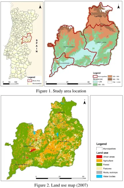
The Beira Baixa region is an administrative division in eastern Portugal. The region covers an area of 4,614.6 km² and has a population of 84,046 inhabitants. The area includes four municipalities: Idanha-a-Nova,
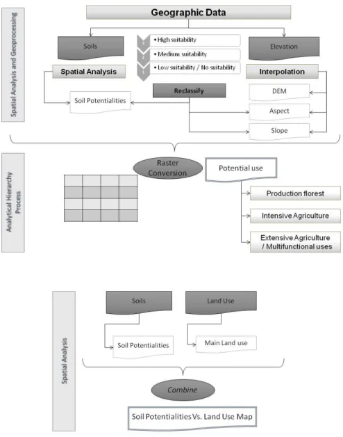
Penamacor, Vila Velha de Ródão and Castelo Branco (Figure 1). This territory is mainly occupied by forest and agroforestry uses (60.8 %) and agriculture (36.2 %) (Figure 2).
Figure 1. Study area location
Figure 2. Land use map (2007)
Figure 3 presents the methodology used to determine suitability for agroforestal land uses, namely production forest, intensive agriculture and extensive agriculture/ multifunctional uses (agroforestry).
The spatial data sets for the study were obtained from the following sources: • Fifth level Corine Land Cover, European land occupation database (DGT).
• Shuttle Radar Topography Mission (SRTM) - Digital Elevation Model (NASA and NSA). • Soil cartography (IHERA).
Figure 3. Methodology work flow
The classification of agroforestal suitability resulted from the integration of a set of biophysical criteria using ArcGIS 10.2 software, based on the climate and soil requirements of crops and forest stands and the optimal operating conditions associated with different uses. Geoprocessing and spatial analysis was performed to geographic data, namely soils, elevation in order to produce the following layers: soil potentiality, slope and aspect.
To define the soil potential for different crops and forest stands the soil theme attribute table was edited. Soils were reclassified in potentiality classes shown in Table 1.
Table 1. Soil potentialities (UNESUL, 1996) Potentiality
class Soil characteristics Potential use
I
Different soil types that present high to very high constraints to production uses due to soil thickness, vulnerability to erosion or stoniness. With very low fertility.
Woodland and scrub with soil protection and recovery functions. In some cases, more favorable, pasture under a “montado”
system.
II
Soils with coarse texture, without severe erosion problems, generally with low to very low fertility.
Forestry (pineyards and “montado” system), pastures, vineyards. In some cases cereal crops and horticulture if water and organic matter is available.
III Soils without severe erosion problems. With medium to low fertility.
Cereal crops, horticulture, orchards and improved pastures. Forestry.
IV Soils without erosion problems. With medium to high fertility.
Cereal crops in intensive mode, orchards, improved pastures and forestry. Soils suitable for olive groves.
V Soil with high fertility.
Good for different uses depending from drainage, soil texture and availability of irrigation water: irrigations systems. Intensive forestry.
Rocky outcrops - Not suitable
Social areas Urban areas and water bodies Not suitable
The reclassification of soils in its potentiality is based in their physical and chemical proprieties, namely: texture, structure, field capacity, mineral reserves, organic matter, types of clay, cation exchange capacity, degree of saturation, pH, etc. The factors of soil formation (pedogenesis) have also importance to evaluate soil fertility (UNESUL, 1996).
A digital elevation model (DEM) was generated from contour maps with a pixel size of 100 m. Then we created layers of aspect and slope classes from de DEM. Those layers were reclassified based in their importance as constraints to agroforestal uses. Slope is a limiting factor to land use, affecting, for example, the machinery access and susceptibility to soil erosion. Aspect determines the amount of incident solar radiation, influencing the microclimate.
The different layers were classified in three suitability levels: low or no suitability (1), medium suitability (2) and high suitability (3). After creating layers resulting from the reclassification in suitability levels, the general suitability for each land use was performed using a multicriteria decision analysis - the Analytic Hierarchy Process - AHP (Saaty, 1980).
AHP is based on three main principles which are decomposition, comparative judgment and synthesis of priorities. Pairwise comparison is the basic measurement used in the AHP procedure. The synthesis principles takes of the derived ratio scale local priorities in the various level of the hierarchy and constructs a composite set of alternatives for the elements at the lowest level of the hierarchy (Malczewski 2004). The fundamental concept of AHP lies in proceeding from a pairwise comparison of criteria to evaluate the weights that assign relative importance to these criteria. This method is a very popular in calculating weighting factor.
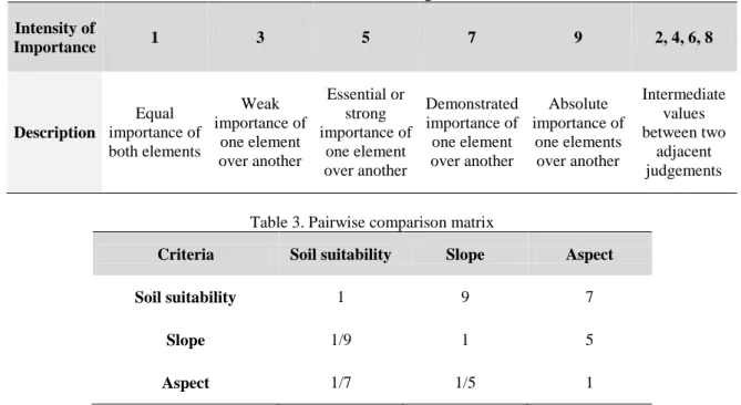
Pairwise comparison is performed based on the rating scale proposed by Saaty (1980) shown in Table 2. Two factors are compared using the rating scale which ranges from 1 to 9 with respect to their relative importance. This parameter is computed against each pair based on the opinion of experts. The relative importance between each criteria is shown in Table 3.
Table 2. Pairwise rating scale Intensity of Importance 1 3 5 7 9 2, 4, 6, 8 Description Equal importance of both elements Weak importance of one element over another Essential or strong importance of one element over another Demonstrated importance of one element over another Absolute importance of one elements over another Intermediate values between two adjacent judgements
Table 3. Pairwise comparison matrix
Criteria Soil suitability Slope Aspect
Soil suitability 1 9 7
Slope 1/9 1 5
Aspect 1/7 1/5 1
ArcGIS software was used to process the input where the priority of each factor is calculated using the eigenvectors. The weights calculated using AHP are shown in Table 4.
Table 4. Criteria weights
Criteria Eigenvalues Eigenvector of largest Eigenvalue Weights Soil suitability 3,3974 0,9766 77,91% Slope -0,1987 0,2018 16,10% Aspect -0,1987 0,075 5,99% [Consistency ratio CR= 0.3821]
As a conclusion from the literature reviews and discussion with experts in agrarian sciences, a criterion factor for suitable areas for forest and agriculture as shown in Table 5.
Table 5. Criterion factor and ranking
Criteria Classes Suitability Production forest Intensive agriculture Extensive agriculture/ Multifunctional use Soil suitability Class I Class II Class III Class IV Class V Social areas Rocky outcrops 1 3 3 2 2 1 1 1 2 2 3 3 1 1 2 3 3 2 2 1 1 Slope 0 - 3% 3% - 8% 8% - 16% 16% - 30% > 30% 3 3 2 2 1 3 3 2 2 1 3 3 3 2 1 Aspect Flat South/West East North 3 3 3 3 2 2 3 2 2 2 3 2 3 - high suitability; 2 - medium suitability; 1 - low suitability / no suitability
In the end, a spatial analysis was performed in order to confront the land use with the soil potentiality. For that purpose the ArcGIS command combine was used. This command generate combinations of values from two layers. From the analysis of the resulted layer the degree of compliance between land uses and land suitability.
Results, Discussion and Conclusion
In order to obtain the slope and aspect maps (Figure 4 and 5) from DEM a surface analysis was performed.
Figure 4. Slope map
Figure 5. Aspect map
From the reclassification of soil layer we obtain a map representing its potentialities (Figure 6). This map allows to identify the forest and agricultural uses more suitable to the different soils, and areas not suitable for production.
Figure 6. Soil Potentiality
In the following maps we present the results of Analytical Hierarchy Process (Figure 7, 8 and 9)
Figure 7. Suitability for production forest
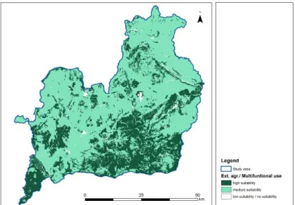
Figure 9. Suitability for Extensive agriculture/ Multifunctional use
Figure 10 shows the degree of accordance between the soil potentiality and the land use resulting from local spatial analysis using combine tool.
Figure 10. Soil suitability vs. Land use
The use of GIS for identifying and mapping land use suitability was verified in this study. GIS is one of the mostly used technologies in land suitability mapping. The methodology presented in this paper using GIS and MCDA as a tool to aid decision-making process with particular case study of locating suitable areas for different agroforestal uses.
This methodology allows the correct evaluation of the natural suitability of the land, using a set of biophysical criteria. It contributes, also, to the discussion about the adequacy of current and future uses taking into account the environmental carrying capacity.
The implementation of this spatial data analysis approach could be a useful tool for stakeholders in land use planning and management.
Acknowledgements
This research was funding by FCT - Fundação para a Ciência e a Tecnologia in the aim of the PEst-OE/AGR/UI0681/2011 project.
References
Antunes, O.E.D., (2012). Análise Multicritério em SIG para Determinação de um Índice Espacializado de Pressão Antrópica Litoral. Casos de Espinho, Caparica e Faro. Dissertação de Mestrado em Gestão do Território. Área de Especialização em Deteção Remota e Sistemas de Informação Geográfica. Universidade Nova de Lisboa. Faculdade de Ciências Sociais e Humanas. Lisboa.
Collins, M. G., Steiner, F. R. & Rushman, M. J. (2001). Land-use suitability analysis in the United States: historical development and promising technological achievements. Environment Management. v. 28, n. 5, pp. 611-621.
FAO (1976). A framework for land evaluation. FAO Soils bulletin 32. Rome.
Kangas, J., Store, R.L., Leskinen, P., Mehtatalo, L. (2000). Improving the Quality of Landscape Ecological Forest Planning by Utilizing Advanced Decision-Support Tools. Forest Ecology and Management, Amsterdam, v.132, p.157-171.
Malczewski, J. (2004). GIS-based land-use suitability analysis: a critical overview. Progress in Planning, v. 62, n. 1, pp. 3-65.
Parimala, M. & Lopez, D. (2012). Decision making in agriculture based on land suitability – Spatial data analysis approach. Journal of Theoretical and Applied Information Technology, Vol. 46 No.1, pp. 17-23.
Quinta-Nova, L.C., Roque, N., (2014) Agroflorestal Suitability Evaluation of a Subregional Area in Portugal Using Multicriteria Spacial Analysis. Internacional Congress of Landscape Ecology – Understanding Mediterranean Landscapes Human vs. Nature, 23-25 October. Antalaya. Turkey.
Roy, B. (1996). Multicriteria methodology for decision aiding. Dordrecht. Kluwer Academic.
Reynolds, K.M. & Hessburg, P.F. (2005). Decision support for integrated landscape evaluation and restoration planning. Forest Ecology and Management 207: 263-278.
Saaty, T.L. (1980). The Analytical Hierarchy Process: Planning, Priority Setting, Resource Allocation. 1st Ed., McGraw-Hill, New York.
Schmoldt, D.L., Mendosa, G.A. & Kangas, J. (2001). Past Developments and Future Directions for the AHP in Natural Resources. In: D.L. Schmoldt, J. Kangas, G.A. Mendoza and M. Pesonen (eds.), The Analytic Hierarchy Process in Natural Resource and Environmental Decision Making, pp: 289-305. Kluwer Academic Publications, Dordrecht, The Netherlands.
Schmoldt, D.L. & Peterson, D.L. (1997). Using the Analytic Hierarchy Process for Decision-Making in Ecosystem Management. Analysis Notes of the W/O Ecosystems Management Analysis Centre, Fort Collins, Colorado, USA: Vol. 7, Issue 1: 17-22.
Steiguer, J. E., Liberti, L., Schuler, A., Hansen, B., (2003). Multi-Criteria Decision Models for Forestry and Natural. USDA Forest Service, Northeastern Research Station, pp. 8; 16-23.
UNESUL (1996). Análise da evolução de uma área da Península de Setúbal na sequência de um processo de alteração de uso. Relatório final do projecto 16/94 do Programa estímulo à investigação no domínio do Ordenamento do território e do Desenvolvimento Urbano, Associação Universidade-Empresa do Sul, Évora.
Author Information
Luís Quinta-NovaEscola Superior Agrária do Instituto Politécnico de Castelo Branco, Quinta da Senhora de Mércules,
6000 Castelo Branco, Portugal
Centro de Estudos de Recursos Naturais, Ambiente e Sociedade, Quinta da Senhora de Mércules, 6000 Castelo Branco, Portugal
Phone: +351272339900 Fax: +351272339901 Contact e-mail: [email protected]
Natália Martins Roque
Escola Superior Agrária do Instituto Politécnico de Castelo Branco, Quinta da Senhora de Mércules,
6000 Castelo Branco, Portugal Phone: +351272339900 Fax: +351272339901