Universidade de Lisboa
Faculdade de Ciˆencias
Departamento de Inform´
atica
Sidra5: A Search System with
Geographic Signatures
David Jos´
e Vaz Cruz
Mestrado em Engenharia Inform´
atica
Universidade de Lisboa
Faculdade de Ciˆencias
Departamento de Inform´
atica
Sidra5: Scalable Search System with
Geographic Signatures
David Jos´
e Vaz Cruz
Projecto orientado pelo Prof. Dr. M´ario J. Gaspar da Silva
Mestrado em Engenharia Inform´
atica
Resumo
Este trabalho consistiu no desenvolvimento de um sistema de pesquisa de informa¸c˜ao com racioc´ınio geogr´afico, servindo de base para uma nova abordagem para mod-ela¸c˜ao da informa¸c˜ao geogr´afica contida nos documentos, as assinaturas geogr´aficas. Pretendeu-se determinar se a semˆantica geogr´afica presente nos documentos, cap-turada atrav´es das assinaturas geogr´aficas, contribui para uma melhoria dos resul-tados obtidos para pesquisas de cariz geogr´afico. S˜ao propostas e experimentadas diversas estrat´egias para o c´alculo da semelhan¸ca entre as assinaturas geogr´aficas de interroga¸c˜oes e documentos. A partir dos resultados observados conclui-se que, em algumas circunstˆancias, as assinaturas geogr´aficas contribuem para melhorar a qualidade das pesquisas geogr´aficas.
PALAVRAS-CHAVE:
Abstract
The dissertation report presents the development of a geographic information search system which implements geographic signatures, a novel approach for the modeling of the geographic information present in documents. The goal of the project was to determine if the information with geographic semantics present in documents, captured as geographic signatures, contributes to the improvement of search results. Several strategies for computing the similarity between the geographic signatures in queries and documents are proposed and experimented. The obtained results show that, in some circunstances, geographic signatures can indeed improve the search quality of geographic queries.
KEYWORDS:
Contents
List of Figures vii
List of Tables ix
1 Introduction 1
1.1 Objectives . . . 2
1.2 Document Structure . . . 3
2 Related Works 5 2.1 Extraction and Desambiguation of Information . . . 6
2.2 Data Structure and Indexing . . . 7
2.3 Ranking and Querying . . . 7
2.4 User Interfaces . . . 7
2.5 Conclusion . . . 8
3 From Textual Retrieval to Geographic Signatures 9 3.1 Approaches . . . 9 3.2 How to Measure? . . . 11 4 Sidra5 13 4.1 Requirements . . . 13 4.2 Architecture . . . 15 4.3 Indexes Structure . . . 15
4.4 Sidra5 in the Tumba! Search Engine . . . 17
4.5 Sidra5 in the XLDB GeoCLEF prototype . . . 18
4.6 Text IR Framework . . . 19 4.6.1 Evaluation Criteria . . . 20 4.6.2 Evaluated IR Frameworks . . . 21 4.6.3 Test Specifications . . . 24 4.6.4 Evaluation Results . . . 25 v
5.2 Geographic Ranking . . . 33 6 Evaluation 39 6.1 Specification . . . 39 6.2 Results . . . 42 7 Conclusion 53 7.1 Future Work . . . 54
A Data Tables & Topics 57
Acronyms 69
Index 69
List of Figures
3.1 Example of geographic hierarchy subset . . . 10
4.1 Sidra5 architecture . . . 14
4.2 Text Index Structure . . . 16
4.3 Geographic Index Structure . . . 16
4.4 Tumba! Search Engine Architecture . . . 17
4.5 XLDB’s GeoCLEF evaluation prototype architecture . . . 19
4.6 MAP values for the 50 TREC topics on the Gov1 collection . . . 26
4.7 Interpolated-precision/recall curve for the TREC results . . . 27
4.8 Indexing time . . . 29
5.1 Flow chart of searches in Sidra5 . . . 32
5.2 Example of the calculation of the four GeoScore combination metrics 35 6.1 Histogram of length of geographic signatures in documents . . . 46
6.2 Runs flux diagram . . . 47
6.3 MAP values of the GeoScores for the Terms/GIR strategy . . . 48
6.4 MAP values of runs before query expansion . . . 49
6.5 Interpolated Precision-Recall curve for runs before query expansion . 50 6.6 MAP values fo the best run for each strategy . . . 51
List of Tables
3.1 Examples of document excerpts and queries . . . 10
3.2 Search quality test specification . . . 11
4.1 Feature matrix of several IR libraries . . . 22
4.2 Search quality test specification . . . 24
4.3 Indexing time test specification . . . 25
4.4 Index size test specification . . . 25
4.5 MAP values for the TREC topics . . . 28
4.6 Comparison of indexing time and index size . . . 28
6.1 CLEF document collections . . . 40
6.2 Statistics of document geographic signtures . . . 40
6.3 Descriptions of the tests . . . 41
6.4 MAP results obtained for the GeoCLEF task . . . 42
A.1 Distribution of Dsig by the number of geographic references . . . 57
A.2 Topics of the Web track from TREC 2004 . . . 62
A.3 Portuguese topics for GeoCLEF 2007 . . . 64
A.4 English topics for GeoCLEF 2007 . . . 65
Chapter 1
Introduction
The information search paradigm has become an essential part of our lives. Search systems are everywhere, from search engines, e-mail applications and web web browsers, to desktop search applications. We are overflowen by information and the world wide web is one of the main drivers. The web has experienced expo-nential growth and shows no sign of slowing down. This simple observation reveals the growing dependence of search engines on sustaining our growing need for infor-mation. We need tools to ease our information mining needs.
Search engines must constantly evolve to be able to accommodate an increasingly larger amount of information published on the web, while responding at the same time to the users’ growing demand for more precise and accurate search results.
In order to return relevant results, matching users’ expectations, it becomes nec-essary to perceive the information need using a few input words. It is crucial that the context in which the query appears is understood, so that search efforts can focus in the information that conforms to that context. In this effort of contextu-alization, a query analysis performed by Sanderson and Kohler [2004] showed that around 15% of search engine queries have a well defined geographic context, and Zhang et al. [2006] showed that geographic queries have in average a higher number of characters and terms. The presence of more information in geographic queries, which in part has a more restrictive context, enables potentially improved results.
Geographic queries open up a new set of opportunities, not without an all new set of difficulties and challenges. They require the creation of representations of geographic knowledge for machine reasoning; understanding the geographic scopes of web documents and disambiguating among possible conflicting meanings for a geographic term; creating new indexing schemas that account for the inclusion of geographic information; developng new ranking algorithms that measure the geo-graphic relevancy of the documents relatively to the query; extracting the geogeo-graphic information, explicitly or implicitly, submitted by the users in queries.
Geographic Information Retrieval (GIR) emerged as the study of the retrieval and processing of geographic information. As an outcome of the research in GIR of the XLDB group, the Tumba! search engine, initially a purely textual search engine, was extended with geographic capabilities. Impelled by the participations on GeoCLEF [Martins et al., 2006][Gey et al., 2006], the GeoCLEF track of CLEF, this year Tumba! applied a new approach to model, index, rank and retrieve geo-graphic information, representing all the geogeo-graphic information present on queries and documents in data structures designated as geographic signatures. Geographic Signatures represent all the geographic references, and respective confidence mea-sures, contained in a document or in a query.
In the research environment where Tumba! is being developed, new algorithms are constantly surfacing, new techniques must be tested and new usage scenarios must be considered. This constant need to catch-up with innovations on topics related to the core research of the group requires a substantial amount of effort and limits the amount of time that can be spared on system maintenance tasks.
The recency of the GIR research area allows a whole spectrum of opportunities. the use of geographic information to surpass textual retrieval techniques is largely untackled, making GIR an atractive research subject.
The scope of the geographic signatures approach is not confined to academic research. As it matures, it will become a concrete functionality of the Tumba! search engine, which will be used to support geographic searches submited by users. This work describes the use of the geographic information as geographic sig-natures by Sidra, the component that is responsible for the indexing and ranking processes of the Tumba! search engine. It also describes the integration of the Sidra in the Tumba! search engine and in the XLDB GeoCLEF framework, a pro-totype built for evaluation purposes that was used by the XLDB Group in its 2007 participation of GeoCLEF.
1.1
Objectives
For the development of the new Sidra version, version 5, the following objectives were identified:
Geographic Relevance based on Geographic Signatures: the new version of Sidra should implement a novel approach for searching geographic information, based on geographic signatures.
This approach intends to overcome the limitations detected in previous ap-proaches, which lead to the observation that the premise of one geographic scope per document was too vulnerable to the wrong assignment of geographic
Chapter 1. Introduction 3 features to documents (geographic features being conceptualizations of phys-ical and administrative locations), and was sometimes too restrictive[Martins et al., 2006].
Geographic Signatures Search versus Textual Search: determine if the pro-posed approach of representing geographic information and calculating the geographic similarity of documents using geographic signatures could obtain better search results than purely textual searches.
Geographic Scoring Strategies Comparison: implement and evaluate geographic scoring strategies based on geographic signatures for their reasoning.
Reduce Maintenance Efforts: the new version of Sidra should bring a reduction of required maintenance efforts, both at the administrative level and at the software development level, simplifying the configuration and installation of the Tumba! search engine, by favoring the use of existing and well documented modules to perform specific tasks.
Sidra5 was built in a more modular fashion, allowing a lower effort on the im-plementation of new relevance algorithms. Taking advantage of the rewriting of this component, a new textual indexing and ranking software module was selected to be included in Sidra5.
1.2
Document Structure
The rest of this thesis has the following structure:
Chapter 2 – reviews some of the main works in Geographic Information Retrieval, divided into four categories: information extraction and disambiguation, data structures and indexing, ranking and search, user interface.
Chapter 3 – rediscovers the research path that led to the formulation of the ge-ographic signatures approach. It gives examples of deficiencies of previous approaches that geographic signatures aim to surpass. This chapter ends with a description of the evaluation measures for search quality, which are used in this work.
Chapter 4 – presents the architecture of Sidra5, describing its components and detailing the integration of Sidra into the Tumba! search engine and into the test prototype used for evaluations on GeoCLEF 2007. It also provides a comparative analysis of a set of existing Information Retrieval libraries, with the purpose of selecting one of them to be included in the next version of Sidra
as the textual indexing and ranking component. Further tests on the indexing and search quality of the libraries are also described.
Chapter 5 – details the architecture for a geographic search system based on geo-graphic signatures, describing the structure of geogeo-graphic signatures and the processes of geographic indexing, relevance calculation and search.
Chapter 6 – evaluates the geographic signatures approach using the topics of the 2007 edition of GeoCLEF, comparing several geographic scoring strategies in multiple query expansion scenarios. This chapter also details the results obtained using geographic signatures with the results of a purely textual ap-proach.
Chapter 7 – recapitulates the initially proposed objectives and discusses the extent of their achievements and outilnes the conclusions on the use of geographic signatures on geographic search systems. The last chapter also ends with some directives for future works dedicated to extending and improving the geographic signatures approach.
Chapter 2
Related Works
As a sub-area of Information Retrieval (IR), Geographic Information Retrieval (GIR) has lately received a considerable attention by the scientific community.
There are two distinct approaches to the challenge of geographic information search, intended to respond to distinct necessities: GIR and Geographic Information Systems (GIS).
There is sometimes a lack of understanding of what differentiates these two dis-ciplines, originating doubts about the necessity and utility of the existence of GIR processes. Although both are devoted to the retrieval of geographic information, their objectives and methods differ. Essentially, the difference between GIS and GIR is similar to the difference between relational databases and classic IR sys-tems. GIS are devoted to the capture, management, analysis and presentation of geographically-related information, resorting to data structures that enable choos-ing the entities that match some logical selection criteria. The goal of GIR is, given a geographic context, to recover the information considered as potentially relevant, by order of relevance, in the most efficient possible way.
In search engine contexts, the concern is on the efficiency in the retrieval of rel-evant results and the quality of those results. As such, GIR has been driven by the search engine necessities to augmentate the quality of their services to users, trying to contextualize and adjust to their momentary needs.
A diversity of works about GIR have appeared recently. These works can be divided into four areas:
• Extraction and disambiguation of information • Data structures and indexing
• Ranking and querying • User interfaces
2.1
Extraction and Desambiguation
of Information
Extraction refers to the tasks of identifying geographic information contained in web documents and/or information contextually relevant to the geographicity of the document. Desambiguation refers to the resolution of ambiguous geographic information, such as identical names for distinct localities.
The beginning of any geographic retrieval task resides in identifying the geo-graphic information present in web documents (extraction).
Silva et al. [2006] presented a methodology for the attribution of geographic contexts to documents of the Portuguese web using an ontology that maps the geographic knowledge as geographic concepts and their relationships.
Yi Li and Cavedon [2006] and Markowetz et al. [2005] assigned multiples geo-graphic contexts to web documents. This approach, based on probabilities, enables the association of documents to mutiple geographic contexts.
Julien Lesbegueries and Gaio [2006] assigned geographic contexts to textual units (such as sections, paragraphs and sentences) and tryed to infer geographic patterns inside documents with this information.
Qi Zhang and Ma [2006], aside the association of geographic contexts to docu-ments, also calculated serving scopes. The serving scope corresponds to the serving area that a given resource has in a given geographic context. For example, the serv-ing scope of a query for “Restaurants in Lisbon” will be substantially smaller that a query for “Airports in Lisbon”.
In Graupmann and Schenkel [2006], all the geographic references that exist in the documents are preserved. When a query is performed on the documents, only the geographic references that arise in a context similar to the query context are used for the purpose of ranking calculation.
Tezuka et al. [2006] presented a system that identifies the geographic contexts of documents and associates additional external information that refers to the same geographic context.
Souza et al. [2005] discussed the contribution of gazetteers to the identification and assignment of geographic meaning to documents, focusing particularly on the benefit of ontologically enhanced gazetteers in the discovery of the geographic con-text present on documents.
Walker et al. [2005] proposed and evaluated spatial Bayesian network algorithms as a mean for automatically infering the relationship between geographic contexts.
Chapter 2. Related Works 7
2.2
Data Structure and Indexing
The use of geographic information spawned the development of new data struc-tures that profit from this additional information in the indexing phase.
Zhou et al. [2005] describe comparative tests to three distinct hybrid spatial indexing strategies which combine textual and geographic information, concerning to the performance and information storage cost.
Zhisheng Li [2006] used two types of indexes. One index maps the hierarchical relation between explicit and implicit locations allowing the inference of locations relevant to a given search context. The other index associates the locations to a grid, enabling search by proximity.
Andrade and Silva [2006a] presented geographic information indexing structures. These structures separate the geographic and textual information, allowing the search of only one type of information.
Martins et al. [2005] presented index structures that benefit from several data structures: inverted indexes, spatial indexes and geographic ontologies.
2.3
Ranking and Querying
The availability of additional geographic information can be used by the IR rank-ing algorithms. To profit from this additional information, new rankrank-ing algorithms have been created. Also, it is now essential to identify which queries are geographic. Andrade and Silva [2006b] presented a ranking schema to relate two locations. They also evaluated several strategies for combining textual and geographic infor-mation and the benefits of these approaches.
Markowetz et al. [2005] presented a ranking algorithm which intersects textually relevant documents with the documents’ geographic footprints, to determine which are relevant to a query.
Zhang et al. [2006] analysed the structure of user submitted queries and how users rewrite queries to adjust the geographic context of submitted queries.
Bruno Martins and Afonso [2006] described a methodology to interpret and dis-ambiguate user submitted queries using a geographic ontology.
Chen et al. [2006] analyzed the scalability of several algorithms for geographic queries processing, evaluating the efficiency of several strategies to combine textual and geographic information.
2.4
User Interfaces
Since the final objective of a geographic search system is to be useful to its users, the user interface is crucial to its acceptance and success. In this domain, new ways
to present geographic information have been researched, as well as novel forms of user interaction for the input of geographic information in queries.
Ware et al. [2002] presented a solution to resolve the incoherences that appear on maps as its scale decrease.
Tezuka et al. [2006] presented a proactive geographic search system, heavily inspired on car radios. The user chooses a query type (e.g., restaurants) and the results are constantly being updated as the position of the vehicle, received through GPS, changes.
Carmo et al. [2005] describe a prototype of a geographic referenced information system which allows the filtering of the information presented to the users according to some semantic criteria.
Hobona et al. [2005] presented a 3D interface for the presentation of results. The results entry are placed along three axis on semantic, temporal and geographic relevance.
2.5
Conclusion
GIR is a broad research area with very diversified works. It is rapidly evolving due to the ever growing internet demand for contextually more precise information. Yet, GIR still has to prove its efficacity relatively to the classic IR.
Markowetz et al. [2005] gave a complete view of how to integrate techniques of information extraction and disambiguation, indexing and search to create a com-pletely functional geographic search engine. The approach used in the prototype for the modeling of the documents’ geographic information, called geographic foot-prints, considers that a document can contain (and they usually do) more than one geographic reference and that all of them have to be considered. This idea is similar to the one used for the geographic signature approach described in this work, but its advantages still have to be demonstrated.
Chapter 3
From Textual Retrieval to
Geographic Signatures
Textual Retrieval has been the standard for search technologies. Despite its wide spread utilization, the use of words as search tokens limit its overall effectiveness. Neither the geographic semantics nor the distance and hierarchical notions are inter-preted and considered. This provides a window of opportunity for GIR techniques to surpass their textual homologous.
This chapter outlines the past research on GIR by the XLDB group, from the textual retrieval to geographic signatures. Section 3.1, summarily describes the used approaches and explains the motivation for each evoluationary iteration. Section 3.2, identifies the evaluation metrics used, during all this work, to compare the search quality of different algorithms and approaches.
3.1
Approaches
The retrieval approaches that have been the object of past research on the XLDB group for processing geographic queries are:
Text Retrieval: this approach has no explicit geographic processing. It partitions the document into tokens, usually words, and uses probabilistic algorithms to match the tokens of the documents with those present in the queries.
One geographic feature by document: this approach gathers all the geographic references contained in a document and assigns, as the geographic scope of the document, the geographic feature that best describes all the contained refer-ences[Martins et al., 2006].
Geographic Signature: this approach gathers all the distinct geographic refer-ences contained in the document into a data structure (geographic signature).
Document
d1 “When visiting Portugal, the
restaurants that you cannot miss are ...”
d2 “...eated, last night, in a small
restaurant of Bragan¸ca called
...”
d3 “You can visit our other
restau-rants in Oporto, Bragan¸ca, ...” d4 “...where you can taste the finest
seafood that Lisbon has to offer. This restaurant ...”
(a) documents
Queries
q1 Restaurants in Portugal
q2 Restaurants in Bragan¸ca
q3 Restaurants in Bragan¸ca and
Oporto
(b) queries
Table 3.1: Examples of document excerpts and queries
Portugal
Lisbon
Oporto Bragança
...
... ...
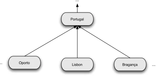
Figure 3.1: Example of geographic hierarchy subset
The geographic scope of the document is then composed of all of these ref-erences, each with a weight value that describes their importance in the geo-graphic signature.
To ease the understanding of the motives that led to the successive evolutions, some fictional document excerpts (see Table 3.1a) and queries (see Table 3.1b) were used as examples. Additionally, Figure 3.1 contains a graph which represents the hierarchy of the geographic concepts contained in both the query and document examples.
Chapter 3. From Textual Retrieval to Geographic Signatures 11
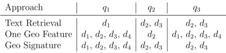
Approach q1 q2 q3
Text Retrieval d1 d2, d3 d2, d3
One Geo Feature d1, d2, d3, d4 d2 d1, d2, d3, d4
Geo Signature d1, d2, d3, d4 d2, d3 d2, d3
Table 3.2: Search quality test specification
Since textual retrieval has no notion of what is “geographic information” (such as geographic features, geographic names, spatial and hierarchical relations), it is only able to retrieve documents that explicitly contain the query terms. For this reason, in q1, textual retrieval only recovers d1 despite d2, d3 and d4 being potentially
relevant, since they are all siblings of the node referred in the query (Portugal). To overcome the lack of hierarchical notion, the “one geographic feature by doc-ument” approach was created. However, this may be too simplistic, since “one geographic feature by document” adjusts the document scope to the geographic fea-ture which best encompass all the geographic references contained in the document. For example, in q2, “one geographic feature by document” shows a lower retrieval
quality when compared to the textual search (less documents retrieved). In q3, too
many documents are retrieved since d4 is mistakenly retrieved. This is caused by
over-generalization of the query.
The geographic signature approach came as a natural evolution. It retrains the hierarchical notion that allows to retrieve all the correct documents for q1, yet its
finner granularity allows to answer correctly to q3.
Theorically, the geographic signatures approach benefits from the notion of ge-ographic knowledge, without suffering the shortcomings of “one gege-ographic feature by document”.
3.2
How to Measure?
When faced with a multitude of approaches and strategies to rank information according to multiple search criteria, it is necessary to evaluate then equally. In IR, there are several distinct measures to quantify the performance of search systems. This work will focus on three of them: precision, recall and MAP (Mean Average Precision).
The precision (Pr) is the fraction of the top r ranked documents that are relevant
to the query. Precision is given by the following formula:
Pr =
|{relevant documents}| ∩ |{retrieved documents}|
|{retrieved documents}| (3.1)
were retrieved in the top r. Recall is given by the following formula: Rr =
|{relevant documents}| ∩ |{retrieved documents}|
|{relevant documents}| (3.2)
These two measures can be combined into a measure called interpolated precision. It corresponds to the maximum precision value at (typically) 11 equidistant cut points from 0 percent to 100 percent of recall. Since recall is a non-decreasing function of rank the values of the interpolated precision are non-increasing as recall increases.
The MAP measure is the mean value of the average precisions computed for each of the queries separately. Average precision emphasizes returning more relevant documents earlier. It is the average of precisions computed after truncating the results list after each of the relevant documents in turn:
AverageP recision =
PN
r=1(Pr× rel(r))
|{relevant documents}| (3.3)
where r is the rank, N the number of retrieved results, rel() a binary function on the relevance of a given rank.
In today’s competitions, such as CLEF, the MAP value is the main evaluation measure to evaluate the performance of a ranking algorithm.
Conceptually, the geographic signature approach has the potential to surpass the textual retrieval approach. Geographic signatures have to be tested to see if this assumption still holds in real world scenarios. In Chapter 5, the geographic signature specifics are presented and, in Chapter 6, this approach is evaluated.
The next Chapter describes the first software module which implements this novel approach, Sidra5, and describes its integration into two systems.
Chapter 4
Sidra5
Sidra has been used as a component of Tumba!, the search engine created by the XLDB research group, and in the evaluation system used by XLDB in the 2007 Geographic Track of CLEF (Cross Language Evaluation Forum), also known as GeoCLEF[?].
Both in Tumba! and on the GeoCLEF prototype, Sidra assumes the role of indexing and ranking component, even if these two systems have different purposes and architectures. Sidra creates the textual and geographic indexes and does the geographic reasoning, comparing the similarity between queries and documents.
This chapter lists the requirements of Sidra (Section 4.1), details its architecture (Section 4.2), describes the indexes structure (Section 4.3), presents how it was embedded into the two systems (Section 4.4 and 4.5) and describes the selection of the text IR framework used in Sidra (Section 4.6).
4.1
Requirements
The following requirements for the new version of Sidra were defined:
Implement Geographic Signatures: The main requirement for the new version of Sidra was to support the novel geographic signature approach, described in this dissertation.
Integration: Since both the systems where Sidra5 is integrated heavily use com-ponents written in Java, design decision had to be made to ensure a correct integration, favoring software modules written in Java. Additionally, Sidra had to seamlessly run in Linux operative system since the systems where it was integrated require this platform.
Software Reuse: Specific tasks of Sidra are implemented using existing software to achieve bigger modularity, software quality, support and fasten the devel-opment process. The use of open-source software was favored.
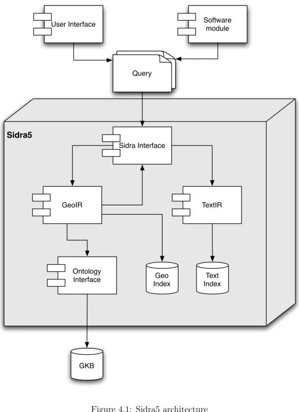
Note Sidra5 Sidra Interface TextIR GeoIR Ontology Interface User Interface Text Index Geo Index GKB Software module Query
Figure 4.1: Sidra5 architecture
Geographic Search “on demand”: Even if 15% of user submitted searches are geographic queries[Sanderson and Kohler, 2004], which justifies the current effort around GIR, the fact is that the majority of queries are not geographic. The new version of Sidra had to ensure that only geographic queries had to
Chapter 4. Sidra5 15 support the additional computational effort required for the geographic rea-soning and ensure that the appropriate calculation of relevance was performed, given the type of input query.
4.2
Architecture
Sidra is a software component with well defined purpose and functions, where the geographic indexing and ranking processes are decomposed into distinct tasks. In the newly developed version of Sidra, version 5, the architecture has been de-signed to emphasize flexibility and modularity, assigning indexing or ranking tasks to interchangeable sub-components. The internal architecture of Sidra5, shown in Figure 4.1, has the following units:
Sidra Interface: This module exposes the functionalities of Sidra5 to external com-ponents. The interface was created with modularity in mind, providing index-ing and rankindex-ing functions. In this module incomindex-ing queries are routed to geographic retrieval or textual retrieval evaluation algorithms.
TextIR: This module offers text retrieval methods. MG4J1, a software library that
provides high indexing and querying efficiency and scalability, while supporting state of the art IR ranking algorithms, was chosen as basis for implementing the text IR framework of Sidra.
GeoIR: This sub-component offers the geographic reasoning methods. It is respon-sible for the geographic indexing and retrieval of signatures.
This module is implemented on top of the Berkeley DB –java edition2.
It is also in this module that the geographic similarities between queries and documents are computed.
Ontology Interface: This component provides an interface with the Geographic Knowledge Base (GKB) [Chaves et al., 2007]. It offers methods to retrieve the information about the geographic entities in the ontology, which is used by heuristics for the computation of geographic similarities.
4.3
Indexes Structure
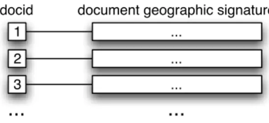
As depicted in Figure 4.1, Sidra5 uses two kinds of indexes: a textual index and a geographic index. The textual index consists of an inverted index [term→<docid>],
1http://mg4j.dsi.unimi.it/
...
term docid #1 docid #n
Figure 4.2: Text Index Structure
... 1
... 2
document geographic signature docid
... 3
...
...
Figure 4.3: Geographic Index Structure
where docid is an unique document identifier. The geographic index is a forward index [docid→geographic signature] (see Figure 4.2 and 4.3 for representations of the text and geographic indexes, respectively). The motivation for this index division is that it allows simultaneous handling of both textual and geographic query types, i.e. queries with and without geographic context, in the most efficient way. If a query is not geographic, only the textual index is used, but if a geographic query is submitted both indexes are used.
For this division to succeed, consistency of the document identifiers in both indexing structures must be ensured. Each document has to have its own identifier and that identifier has to be unique, making it possible to connect the information of the textual index with the information of the geographic index.
With the uniqueness of the documents identification it is then possible to con-struct the two indexes in a parallel and independent fashion. With this index struc-ture it is also possible to reconstruct just one of the two indexes without interfering with the normal behavior of the other one.
Geographic indexing in Sidra is performed in two phases, which can be run in parallel since the uniqueness of document identifiers (docid) is preserved.
1. The text indexing sub-module of Sidra is fed with the documents of the col-lection, creating the text index.
2. The geographic indexing sub-module of Sidra is fed with the geographic sig-natures of documents. It then creates the geographic index.
Chapter 4. Sidra5 17
4.4
Sidra5 in the Tumba! Search Engine
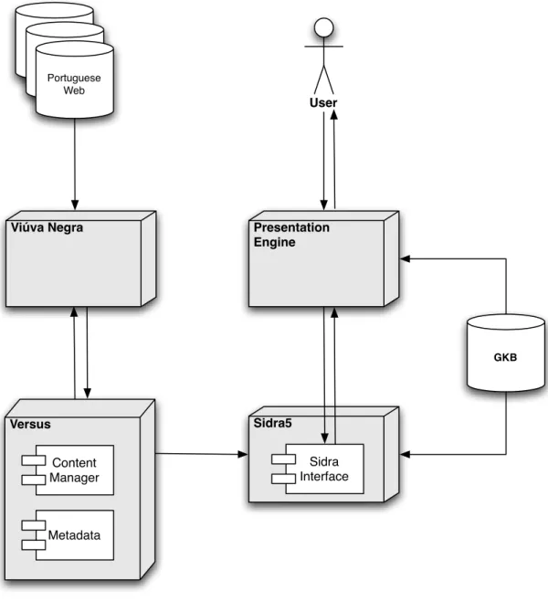
Versus Viúva Negra Sidra5 Presentation Engine Portuguese Web GKB User Sidra Interface Content Manager Metadata
Figure 4.4: Tumba! Search Engine Architecture
The purpose of Tumba! is to provide scalable search capabilities across docu-ments of the Portuguese web. In addition to Sidra, Tumba! has the following main components (see Figure 4.4):
Vi´uva Negra is a web crawler developed internally by the XLDB Group [Gomes,
2001, Gomes and Silva, 2001]. Vi´uva Negra aims to be a highly efficient,
Versus is a repository for webcontent that provides high performance structured access to meta-data and extensible storage space for contents [Gomes et al., 2004]. It is composed by the Content Manager and the Catalog. The Con-tent Manager provides storage space for the conCon-tents and mechanisms for the elimination of duplicates. The Catalog provides high performance access to structured meta-data. It keeps information about each content such as the date when it was collected and the reference to the location where it was stored in the Content Manager.
Presentation Engine is the component in the Tumba! search engine that does an initial analysis of the user’s submitted queries, spell-checking the query, passing it to Sidra, and finally generating the web pages and presenting the results to the user.
GKB stands for Geographic Knowledge Base. It is a repository of geographic data and knowledge rules relating the data [Chaves et al., 2005]. GKB is used by the Tumba! search engine to formulate queries and assess the geographic context of queries and documents.
4.5
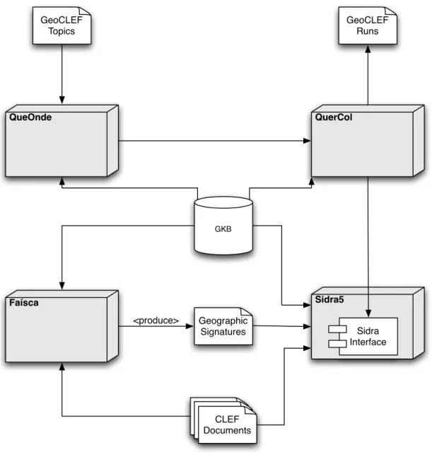
Sidra5 in the XLDB GeoCLEF prototype
The XLDB GeoCLEF framework is a prototype developed for the 2007 edition of GeoCLEF[?]. It was used to evaluate the search results provided by the geo-graphic signature approach. The system architecture of this framework is presented in Figure 4.5, and includes the following components in addition to Sidra and GKB, presented above:
QueOnde is responsible for the query interpretation and their segmentation into triplets of: non-geographic terms, geographic relationship, geographic terms [Cardoso et al., 2007].
QuerCol perform query expansion, both textually and geographically, using the triplets generated by QueOnde [Cardoso et al., 2007]. The latest version of QuerCol considers both the names and feature type names defined in the geo ontology to adjust the query expansion to the type of geographic entities considered [Cardoso and Silva, 2007].
Fa´ısca is a text mining component, responsible for the extraction and disambigua-tion of geographic references found on documents. It is this component that generates the geographic signatures of documents [Cardoso et al., 2007].
Chapter 4. Sidra5 19 GeoCLEF Runs GeoCLEF Topics QueOnde Faísca Sidra5 GKB QuerCol Geographic Signatures Sidra Interface Geographic SignaturesGeographicSignaturesCLEF
Documents <produce>
Figure 4.5: XLDB’s GeoCLEF evaluation prototype architecture
Sidra5 was fully implemented according to the specified architecture. Section 4.6 describes the selection of the IR framework that was used for the TextIR component. The evaluation of Sidra5 is done on Chapter 6, using the GeoCLEF prototype as the test vehicule to evaluate the validity of the geographic signatures implemen-tation.
4.6
Text IR Framework
Sidra was redesigned to emphasis maintenance ease and modularity, as described in Section 4.1. Part of the redesign decisions of Sidra were to select an existing IR
framework to be used as the textual indexing, ranking and search component. This section describes the selection of the text IR framework. In Section 4.6.1, the requirements are presented; in Section 4.6.2, several IR frameworks are presented and evaluated according to the requirements; in Section 4.6.3, some performance tests are specified and in Section 4.6.4, the pre-selected IR frameworks are compared using the performance tests.
4.6.1
Evaluation Criteria
The following criteria were considered in the evaluation of the IR libraries under consideration:
Licensing Terms: the possibility of modifying, adding new features and redistri-bution of the software are critical.
Price: an essentially relevant issue for non-profit organizations, such as university research groups. Free software is preferred.
Documentation: availability is crucial for a seamless and fast integration of the IR library into the existing system as well as in the development of additional features to add to the IR library.
Implementation Language: may be crucial since it may prevent integration with already existing components. Since the other existing modules are written in Java, software written in Java or with Java bindings is highly preferred. Operating System: some libraries may work only on some platforms, making
them unsuitable for the current deployment strategy. Linux support is manda-tory.
Distributed indexes: search engines are bound to very strict performance require-ments, which lead to the division of the computing tasks among several com-puters. To prevent bottlenecks, distributed indexes that can be generated in parallel are indispensable.
Active development: in software tends to be improved more often and new fea-tures, such as ranking algorithms, are integrated faster. Also, actively de-veloped software has usually an user base created around it, which helps in getting support.
BM25: Okapi’s BM25 ranking algorithm is considered as the state-of-the-art prob-abilistic weighting scheme and baseline for many IR experiments[Robertson et al., 1995]. Its use can be important for obtaining a good search quality.
Chapter 4. Sidra5 21 Anchor indexing: navigation between web pages is made using links that connect them. The pages targeted by the links are described using a short text snippet, called anchor. For a system which indexes web pages, it is essential that, during the indexing phase, the anchor text is indexed together with the page pointed by the link.
Plug-in architecture: Software libraries with a plug-in architecture have greater extensibility. It is possible to add a functionality without touching the core code of the library, thus easing the implementation of new features with min-imum impact to the existing code base.
4.6.2
Evaluated IR Frameworks
In the process of choosing a substitute for Sidra4, several IR frameworks were considered, of which two were selected to be further evaluated, due to time restric-tions. The initial phase selection was conducted by an initial mix of feature require-ment matching (see Table 4.1) and by some informal testing. The two frameworks selected for further testing were:
Apache Nutch: an open-source search engine implemented in Java. It uses Apache Lucene as its indexing and search component, has an integrated web crawler, a MapReduce facility and support for a distributed file system through the use of Apache Hadoop3. Nutch is a very efficient search engine, although lacking
some state-of-the-art ranking algorithms, such as Okapi’s BM25. It has created a huge community around it providing support and documentation. One of its key features is the ability to extend its functionalities through the use of self contained software plug-ins. Nutch is developed by the Apache Foundation. For more information, see http://lucene.apache.org/nutch/.
MG4J is an open-source search engine implemented in Java by the University of Milan. The main objective of MG4J is to offer a highly efficient frame-work, providing state-of-the-art ranking algorithms, for building search sys-tems. MG4J provides a whole arsenal of functionalities, from distributed pro-cessing and index clustering, flexible index construction, to powerful search operators. More than an easy to use framework, MG4J provides full con-trol over the indexing, ranking and search process. For more information, see http://mg4j.dsi.unimi.it/.
The following IR frameworks were initially considered for inclusion into Sidra5 as textual indexing and ranking module, but were considered unsuited:
F eature Sidra4 Nutc h MG4J Lucene Egothor Lem ur T errier Zettair Licence in ternal APL LGPL APL BSD BSD MPL BSD Price free free free free free free free free Do cumen tation scarce abundan t mo derate abundan t scarce abundan t mo derate scarce Implemen tation Lan-guage C++/Ja v a Ja v a Ja v a Ja v a Ja v a C/C++ Ja v a C Op erativ e System Lin ux Ja v a VM Ja v a VM Ja v a VM Ja v a VM Lin ux/Win32/... Ja v a VM Lin ux/Win32/... Distributed indexes y es y es y es y es no y es no y es Activ e dev elopmen t no y es y es y es no y es y es y es BM25 y es no y es no no y es y es y es Anc hor indexing y es y es y es no y es y es y es y es Plug-in arc hitecture no y es no no no no no no T able 4.1: F eature matrix of sev eral IR libr aries
Chapter 4. Sidra5 23 Apache Lucene is a high-performance, full-featured text search indexing and
search-ing library written entirely in Java. Apache Lucene is highly reputed for its performance and scalability, and is vastly used worldwide. There is abundant documentation, including books describing its features [Erik Hatcher, 2004]. Lucene is developed by the Apache Foundation.
Despite its qualities, Lucene was not selected for further evaluation, because it lacks the capabilities to parse HTML files and to correctly index/search the information contained on anchors. See http://lucene.apache.org/java/ docs/index.html for more information.
Egothor is an open source search engine implementation written entirely in Java to ensure cross platform compability. It supports many common file formats, such as HTML, PDF, PS, DOC, XLS. Its architecture enables easy provision for additional file formats. Egothor supports both Boolean and vector searches. However, scalability is not the main focus of this search engine, being currently used mostly as a demo or in small scale projects. See http://www.egothor. org/ for more information.
Lemur Toolkit is an open-source toolkit designed to facilitate research in language modeling and information retrieval. Lemur supports a wide range of industrial and research language applications, such as ad-hoc retrieval, site-search, and text mining.
Lemur is implemented in C/C++, unlike the software used and implemented both in Tumba! and GeoCLEF prototypes. This differentiation from the
current software ecosystem would make its integration more difficult. See
http://www.lemurproject.org/ for more informations.
Terrier is a modular platform for the rapid development of large-scale IR applica-tions, providing indexing and retrieval functionalities, developed by the Infor-mation Retrieval Reasearch Group of the Department of Computing Sciences of the University of Glasgow.
Terrier has various cutting edge features, including parameter-free probabilistic retrieval approaches (such as Divergence from Randomness models), automatic query expansion/re-formulation methodologies, and efficient data compression techniques. Terrier is written in Java.
Despite all the appealing features of Terrier, only the internal version has all these features. The publicly available software is a crippled version, which lacks several of the cutting-edge features and cannot work in a distributed setting. See http://ir.dcs.gla.ac.uk/terrier/ for more information.
Zettair is a compact and fast text search engine designed and written by the Search Engine Group at the RMIT University, Australia. It has been designed for simplicity as well as speed and flexibility, being the handling of large amounts of text one of its primary features.
Yet, its irregular release, lack of updates (the last published version is from 8th September 2006) combined with its implementation in C undermine the efficiency and scalability provided by this software. See http://www.seg. rmit.edu.au/zettair/ for more informations.
4.6.3
Test Specifications
The comparative performance evaluation between Nutch and MG4J was con-ducted according to three criteria: search quality, indexing time and index size. The TREC GOV1 collection was used as the collection of documents for these tests[?]. The GOV1 collection, as subset of the Internet, composed of US gov-ernment websites, has been shown to be sufficiently representative of the internet and it is characterized by a good proportion of inbound/outbound links and a high connectivity between documents [Soboroff, 2002].
Objectives evaluate the quality of the results retrieved by the
IR framework
Collection 1,2 millions of documents from the GOV1
collec-tion of TREC
Hardware Irrelevant
Measurements Mean Average Precision (MAP)
Table 4.2: Search quality test specification
Search Quality: Search quality is vital for the success of any search system. The choice of the IR framework is determinant for the geographic search quality that is built on top of the IR component on Sidra. To help in this selection, the test ecosystem of TREC GOV1 was used (see Table 4.2).
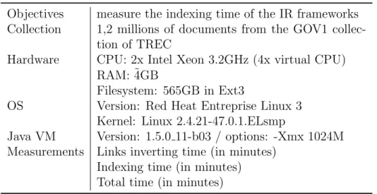
Indexing Time: For large collections of documents, such as the Portuguese web, which is the target of the Tumba! search engine, the indexing time becomes a crucial factor, due to the lack of computational resources. This test intends to find which of the IR frameworks is better suited for large-scale indexing. For the test specification, see Table 4.3. The Link inverting measurement consists in the time spent, by the indexeres, to extract the text anchors and associate to document that it refers. The indexing time measures consists in the time spent by the indexer to create the index batches and combine them as the final index.
Chapter 4. Sidra5 25
Objectives measure the indexing time of the IR frameworks
Collection 1,2 millions of documents from the GOV1
collec-tion of TREC
Hardware CPU: 2x Intel Xeon 3.2GHz (4x virtual CPU)
RAM: ˜4GB
Filesystem: 565GB in Ext3
OS Version: Red Heat Entreprise Linux 3
Kernel: Linux 2.4.21-47.0.1.ELsmp
Java VM Version: 1.5.0 11-b03 / options: -Xmx 1024M
Measurements Links inverting time (in minutes)
Indexing time (in minutes) Total time (in minutes)
Table 4.3: Indexing time test specification
Index Size: For large collections of documents, such as the Portuguese web, target of the Tumba! search engine, the size of the indexes is an important factor due to memory costs. For the test specification, see Table 4.4.
Objectives measure the indexing size obtained by each IR
framework
Collection index of the 1,2 millions of documents from the
GOV1 collection of TREC
Hardware irrelevant
Measurements size (in MB)
Table 4.4: Index size test specification
4.6.4
Evaluation Results
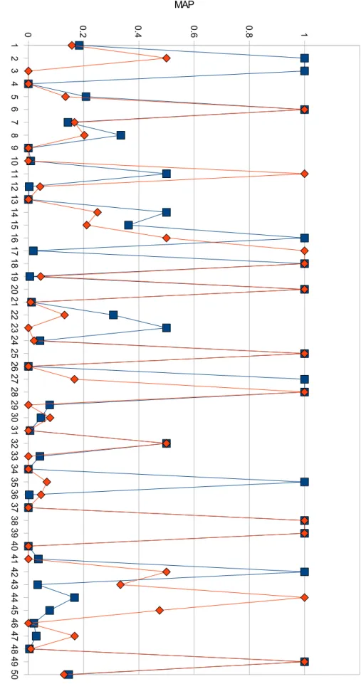
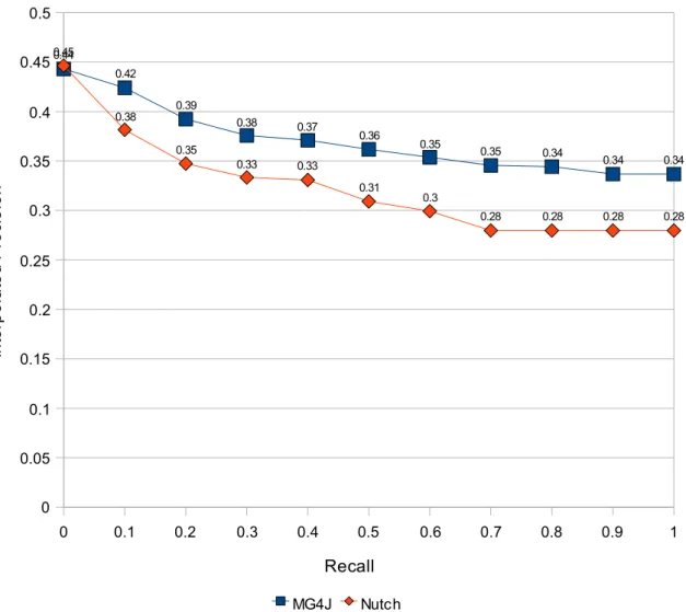
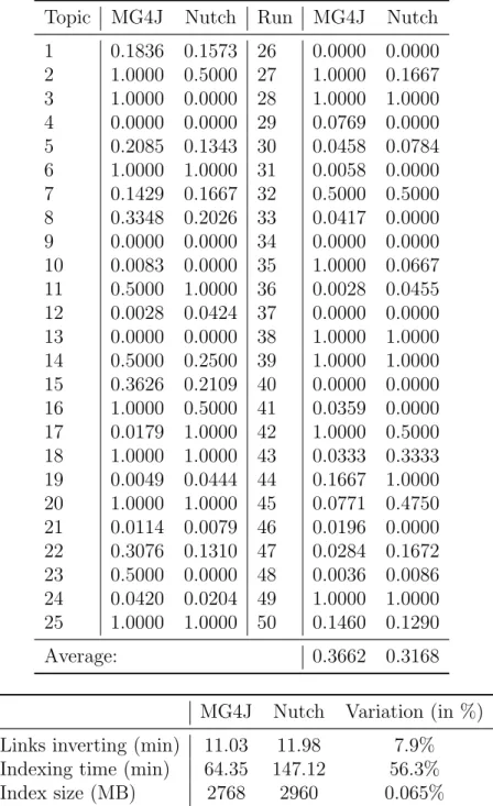
Search Quality: MG4J obtained better results, showing a higher average MAP value than Nutch (0.3662 versus 0.3168). For each topic, both search systems have shown similar trends, with MG4J being more consistent. It had fewer results with MAP values of zero, meaning that it as an higher overall recall (see Table 4.5). The interpolated-precision/recall curve shown in Figure 4.7 further shows the superiority of MG4J.
Indexing Time: The results of this tests clearly shows the performance edge that MG4J has over Nutch. Despite the time similarity in the “invert links” task (MG4J was faster by 7.9%), the diference in indexing time is abyssmal with MG4J requiring only 56.3% of the time needed by Nutch for the same task. Indexes Size: MG4J is the winner in this test (see Table 4.6). It was able to
1 2 3 4 5 6 7 8 9 1 0 1 1 1 2 1 3 1 4 1 5 1 6 1 7 1 8 1 9 2 0 2 1 2 2 2 3 2 4 2 5 2 6 2 7 2 8 2 9 3 0 3 1 3 2 3 3 3 4 3 5 3 6 3 7 3 8 3 9 4 0 4 1 4 2 4 3 4 4 4 5 4 6 4 7 4 8 4 9 5 0 0 0.2 0.4 0.6 0.8 1 M G 4 J N u tc h T o p ic MAP
Chapter 4. Sidra5 27 0 0.1 0.2 0.3 0.4 0.5 0.6 0.7 0.8 0.9 1 0 0.05 0.1 0.15 0.2 0.25 0.3 0.35 0.4 0.45 0.5 0.44 0.42 0.39 0.38 0.37 0.36 0.35 0.35 0.34 0.34 0.34 0.45 0.38 0.35 0.33 0.33 0.31 0.3 0.28 0.28 0.28 0.28 MG4J Nutch Recall In te rp o la te d P re ci s io n
Figure 4.7: Interpolated-precision/recall curve for the TREC results
of almost 200MB in indexing a collection of 5847MB (compressed in GZip format). The difference between both frameworks may seem small for today’s standards, but the 1.2 million documents of GOV1 are nowhere near the size of a small partition of the internet like the Portuguese web.
Superior performance combined with better search algorithms make MG4J the best choice as text retrieval component of Sidra5. It has all the main requirements: it is free, open-source, and in active development, it runs in Linux, indexes HTML anchors, implements Okapi BM25 and it is written in Java. Given the above fea-tures, it has shown to be easily integrated into the existing software infrastructure of Tumba! and also easily embeddable in the GeoCLEF prototype.
This chapter presented the architecture of Sidra5 and the structure of its indexes; showed how to integrate Sidra into both the XLDB GeoCLEF prototype and the Tumba! search engine (the integration into Tumba! was not effectuated); tested several text IR frameworks and selected one of them to be included into Sidra. The
Table 4.5: MAP values for the TREC topics
Topic MG4J Nutch Run MG4J Nutch
1 0.1836 0.1573 26 0.0000 0.0000 2 1.0000 0.5000 27 1.0000 0.1667 3 1.0000 0.0000 28 1.0000 1.0000 4 0.0000 0.0000 29 0.0769 0.0000 5 0.2085 0.1343 30 0.0458 0.0784 6 1.0000 1.0000 31 0.0058 0.0000 7 0.1429 0.1667 32 0.5000 0.5000 8 0.3348 0.2026 33 0.0417 0.0000 9 0.0000 0.0000 34 0.0000 0.0000 10 0.0083 0.0000 35 1.0000 0.0667 11 0.5000 1.0000 36 0.0028 0.0455 12 0.0028 0.0424 37 0.0000 0.0000 13 0.0000 0.0000 38 1.0000 1.0000 14 0.5000 0.2500 39 1.0000 1.0000 15 0.3626 0.2109 40 0.0000 0.0000 16 1.0000 0.5000 41 0.0359 0.0000 17 0.0179 1.0000 42 1.0000 0.5000 18 1.0000 1.0000 43 0.0333 0.3333 19 0.0049 0.0444 44 0.1667 1.0000 20 1.0000 1.0000 45 0.0771 0.4750 21 0.0114 0.0079 46 0.0196 0.0000 22 0.3076 0.1310 47 0.0284 0.1672 23 0.5000 0.0000 48 0.0036 0.0086 24 0.0420 0.0204 49 1.0000 1.0000 25 1.0000 1.0000 50 0.1460 0.1290 Average: 0.3662 0.3168
MG4J Nutch Variation (in %)
Links inverting (min) 11.03 11.98 7.9%
Indexing time (min) 64.35 147.12 56.3%
Index size (MB) 2768 2960 0.065%
Table 4.6: Comparison of indexing time and index size between MG4J and Apache Nutch
next chapter will detail how geographic signatures can be used to rank documents according to their relevance.
Chapter 4. Sidra5 29 0 50 100 150 200
Invert links Indexing Total
T
ime (in minutes)
MG4J Nutch
Chapter 5
Ranking with Geographic
Signatures
A query is geographic when it contains geographic information. A good query analysis is crucial for the interpretation of the query context, correctly identifying the existing geographic terms or references.
In the used GIR architecture, the input query is submitted to a component responsible for the geographic information extraction. As shown in the previsou chapter, this component is either the Presentation Engine of Tumba! or QueOnde in the GeoCLEF prototype. From now on, the description will focus on the search process from the GeoCLEF prototype point of view.
The search process is briefly described in Figure 5.1. The identification of the query structure is essential to distinguish geographic queries from non-geographic ones. Sidra uses the query structure to drive the retrieval and ranking processes. If the geographic part is present, it does a geographic retrieval, else it does a classic textual retrieval.
Independently of the query type, both search types share the common steps of textual retrieval:
1. Fetch from the textual index the identifiers of the documents (docid) that match the thematic part of the query
2. Score the documents using the text ranking algorithms 3. Rank the documents
If the query is purely textual, the search ends with the selection of the result sub-set from the top ranked documents. If the query is geographic, some additional steps have to be taken:
1. Fetch from the geographic index the geographic signatures of the documents 31
Query is submitted Retrieve Textually Relevant Documents Text Index Score with IR algorithm Rank documents Query is geographic? Retrieve relevant geographic signatures Calculate GeoScore Combine text score and GeoScore Rank documents Select top-results Present search result Geo Index yes no
Figure 5.1: Flow chart of searches in Sidra5
2. Calculate the similarity score between the geographic signatures of the query and the documents using one of the implemented geographic similarity strate-gies
3. Combine the textual and geographic score of the documents into one unified score
4. Rank the documents from higher to lower score
The rest of this chapter present the structure of the geographic signatures (Sec-tion 5.1, explains how the geographic signatures are used to geographically rank
Chapter 5. Ranking with Geographic Signatures 33 documents and presents the heuristics and strategies used to compare between two geographic signatures (Section 5.2).
5.1
Geographic Signature Definition
Sidra5 uses the geographic signature as the data structure for the geographic indexing, ranking and search.
Almost all the geographic reasoning and processes in Tumba! and in the Geo-CLEF prototypes, presented in the last chapter, revolve around the representation of geographic information in data structures called geographic signatures. The geo-graphic signature approach considers that the geogeo-graphic context of a document is represented by multiple geographic references, in a way similar to Markowetz et al. [2005] and mainly the probabilistic approach of Yi Li and Cavedon [2006].
Geographic signatures represent the geographic information present in queries and documents. A geographic signature is a list of identifiers of geographic features present in the ontology and their corresponding confidence measure (Conf M eas), a value in the [0,1] range, which represents the confidence that the feature is part of the geographic scope. Conf M eas is obtained through an analysis of the surrounding concepts on each case, in a similar way as described by Yi Li and Cavedon [2006].
In the current implementation of the system, geographic signatures of queries (Qsig) have Conf M eas set to 1.0.
Geographic signatures of documents (Dsig) are generated by extracting
geo-graphic names from documents. An excerpt of four document signatures (one per line) from the GeoCLEF collection is given below:
FSP940101-023: 1432[1.00]
FSP940101-024: 6379[1.00]; 6380[1.00]; 6381[1.00]; 8737[1.00]
FSP940101-025: 5838[1.00]; 12332[0.67]; 1048[0.33]; 89[0.33]; 1889[0.33] FSP940101-026: 5838[1.00]; -14[0.25]; 12332[0.25]; 5917[ 0.25]; 8734[0.25]
Despite being very similar in structure, query and document signatures represent different levels of geographic information. A Query Geographic Signature (Qsig) is
a list of identifiers of geographic features present in the used ontology. The purpose of Qsig is to enumerate all the geographic references present in the query for later
search and document similarity evaluation.
5.2
Geographic Ranking
In IR, document ranking means ordering the documents by decreasing relevance relatively to the query terms. Geographic ranking does not change the foundation
of this principle, but requires new document ranking algorithms. The document relevance calculation of this work is based on the previous work by Martins et al. [2006], adapted to support the processing of geographic signatures.
Because geographic signatures comprise multiple geographic features, an addi-tional processing layer was added to the ranking process, and several geographic scoring strategies that could be employed to evaluate the level of resemblance be-tween geographic signatures have been compared. Algorithm 1 represents the generic ranking framework, independent of the geographic scoring method employed. Algorithm 1 Generic Ranking Algorithm
Require: relevant documents Require: Qsig
Require: txt weight
for all doc in relevant documents do tmpscore ← txt weight × doc.score
Dsig ← getDsig(doc.id)
for all sdoc in Dsig do
for all squery in QSig do
geoScore ← computeGeoScore(squery, sdoc)
tmpscore ← updateScore(geoScore, 1 − txt weight)
end for end for
doc.score ← tmpscore
end for
The final score of a document, for a given query, consists in the linear combina-tion of the document textual relevance score and the geographic score between Qsig
and Dsig. The textual score is obtained when the textual part of the query is
evalu-ated using the Okapi BM25 ranking algorithm [Robertson et al., 1995], normalized to values in the interval [0,1] as defined by Song et al. [2004]. The geographic score (GeoScore) is obtained by calculating the geographic similarity between the n geo-graphic features of the Qsig with the m geographic features present in the Dsig using
some evaluation strategy. The final score is obtained using the following formula:
Ranking(query, doc) = TxtWeight × N ormBM 25(query, doc) +
GeoWeight × GeoScore(query, doc) (5.1)
The constants T xtW eight and GeoW eight were both set to 0.5. For this work, four GeoScore strategies were created:
Maximum: Considers that the value of GeoScore between Qsig and Dsig is the
Chapter 5. Ranking with Geographic Signatures 35 from Dsig. This evaluation strategy is represented by the following formula:
GeoScoremax(query, doc) = max(GeoSim(s1, s2)
× Conf M eas(s2)) , s1 ∈ Qsig ∧ s2 ∈ Dsig
(5.2) Mean: Considers that the GeoScore is the average of the similarity values of com-bining Qsig geographic features with Dsig geographic features. This evaluation
strategy is represented by the following formula:
GeoScoremean(query, doc) = avg(GeoSim(s1, s2)
× Conf M eas(s2)) , s1 ∈ Qsig ∧ s2 ∈ Dsig
(5.3) Boolean: Considers that the GeoScore value is 1 if Dsig contains any geographic
feature that is also present in Qsig, and zero otherwise. This evaluation
strat-egy is represented by the following formula:
GeoScorebool(query, doc) =
(
1 if ∃ s1 = s2, s1 ∈ Qsig∧ s2 ∈ Dsig
0 otherwise (5.4)
Null: GeoScorenull is always zero, turning off the geographic scores. This is used
as a baseline metric for comparing results obtained with the other metrics. In the formulae, ConfMeas corresponds to confidence measure associated to each geographic feature of Dsig, as explained in Section 5.1.
Query: Document 1: (...) there are many tourist attractions (...) ...in Hungary, (...)near Portugal, and (...) in Australia.
Tourist attractions in Hungary.
Hungary
Hungary Portugal
1.0 0.33 0.14
Document 2: (...) there are many tourist attractions (...) ...in Budapest.
Australia Budapest 0.64 Query: Document 1: Document 2: Document 1 Document 2 Mean 0.25 0.30 Bool 1.0 0.0 Max 0.75 0.30
The computation of the four GeoScore metrics is illustrated in Figure 5.2, which presents a fictional query (Hungary), and two document surrogates, along with the GeoSim × Conf M eas values and final GeoScore values.
Next, the textual relevance calculation of documents and the geographic simi-larity calculation are presented in detail.
Textual Ranking
The retrieval of potentially relevant documents to a query uses the textual index. To these documents is then applied a ranking algorithm that assigns a relevance score to each one and orders them by relevance order. This textual ranking is calculated by the probabilistic algorithm BM25, where the relevance of each document consists in the weighted sum of terms that occur in the document and in the query [Robertson et al., 1995]. The weight of each term ti is given by the following formula:
BM 25(ti) =
(k1+ 1) × term f req(ti)
k1× ((1 − b) + b × avg doc lendoc len ) + d
× log(N − doc f req(ti) + 0.5 doc f req(ti) + 0.5
) (5.5)
The constants k1 and b were set to the default values of 2.0 and 0.75, respectively.
Because the results obtained by BM25 aren’t necessarily in the interval [0,1], needed for the final ranking score formula, it is necessary to normalize the returned scores. The used normalization formula used is described by Song et al. [2004] and corresponds to:
N ormBM 25(query, doc) = P ti∈docBM 25(ti) × weight(query, ti) P ti∈doclog( N −doc f req(ti)+0.5 doc f req(ti)+0.5 )(k1+ 1) (5.6) Geographic Similarity
Independently of the strategy used for the GeoScore computation, each Qsig
geographic feature has to be compared to each Dsig geographic feature. This process
corresponds to geographic similarity calculation and uses four heuristics: ontological similarity, distance similarity, populational similarity and adjacency similarity. The similarity value is obtained by the following formula:
GeoSim(s1, s2) =(g1× OntSim(s1, s2)) + (g2 × DistSim(s1, s2))+
(g2× P opSim(s1, s2)) + (g4× AdjSim(s1, s2))
(5.7)
where the constants g1 through g4 have been set to:
Chapter 5. Ranking with Geographic Signatures 37 • g2 = 0.2
• g3 = 0.2
• g4 = 0.1
Next, the used geographic heuristics are presented.
Ontological Similarity: Topological Relations of the type “part-of” defined on the ontology, can be used to infer similarity degrees. This similarity is calcu-lated using the number of transitions between common ancestors. The formula used, similar to the measure of Lin [1998], is:
OntSim(scope1, scope2) =
(
1 if scope1 is equal or equivalent to scope2 2×N umCommonAncestors(scope1,scope2
N umAncestors(scope1)+N umAncestors(scope2) otherwise
(5.8)
Distance Similarity: There is an implicit notion that near locations are more
similar than two more distant locations. However, this distance notion is
context-dependent, varying with the size and reference point between both locations.
In this measure, a similarity value of one is reached when some geographic entity is contained inside another or, in other words, the distance between them is zero. A double sigmoidal function is used with a center corresponding to the minimum bounding rectangle diagonal. This function has maximal value when distance is minimal, from which it declines slowly to zero as distance augments, providing a non-linear normalization. In the next formula, D corresponds to distance between scope1 and scope2 and where DM BR corresponds to the
minimum bounding rectangle diagonal distance corresponding to scope2.
DistSim(scope1, scope2) =
1 se scope1 is included in or is father of scope2
1 − (1+sign(D−DM BR)×(1−exp(−( D−DMBR DMBR×0.5) 2)) 2 ) otherwise (5.9)
Populational Similarity: When an inclusion relationship exists between two ge-ographic features, a partial “part-of” relation, the fraction obtained from the comparison of the population of the more specific area with the more global area can be used as a similarity value. This measure shows the relative
im-portance that a region as inside another, and is obtained by: P opSim(scope1, scope2) =
1 if scope1 is equivalent to scope2 P opulationCount(scope1)
P opulationCount(scope2) is scope1 included in scope2
P opulationCount(scope2)
P opulationCount(scope1) is scope2 included in scope1
0 otherwise
(5.10)
Adjacency Similarity: Considering that two adjacent locations are more relevant than two that aren’t, the information provided by the ontology about adja-cency between geographic features is used. A value of one is assigned if two features are adjacent and zero otherwise:
AdjSim(scope1, scope2) =
(
1 if scope1 is adjacent to scope2
0 otherwise (5.11)
Geographic signatures are a novel approach in the modeling of geographic infor-mation for GIR purpose.
In this chapter, the processes needed for geographic search with signatures was described. An indexing scheme was presented which allows efficient and flexible storage of textual and geographic information. A geographic ranking scheme was presented which uses the geographic signatures for the relevance reasoning, describ-ing several distinct geographic scordescrib-ing strategies that use the heuristics described in Martins et al. [2006].
In the next chapter, the geographic signature approach is evaluated. Test sce-narios are presented and the obtained results are evaluated and compared with a pure textual approach.
Chapter 6
Evaluation
This section presents the evaluation of the geographic signature implementation of Sidra5 using the XLDB GeoCLEF test infrastructure. GeoCLEF was choosen because of being a forum devoted to GIR, and having geographic tasks in Portuguese (the target of the Tumba! search engine) and English (the more commonly used language in the internet), among others languages[?].
This chapter starts with Section 6.1, specifies tests with the purpose of identifying the best GeoScore, the impact of several query expansion strategies and to observe how geographic signatures compare to text retrieval. Secondly, Section 6.2 present and interpret test results.
6.1
Specification
The purpose of the tests conducted was to evaluate how the use of geographic se-mantics contributes to a bigger query contextualization and improved search results, validating the geographic signatures centred approach.
The document collection used for the Sidra5 evaluation was taken from the CLEF document collection. It is composed by the articles of 1994 and 1995 of the newspa-pers P´ublico and Folha de S˜ao Paulo, for the Portuguese tests, and by the articles of 1994 of the newspaper Los Angeles Times and the articles of 1995 of the newspaper Glasgow Herald, for the English tests (for more details see Tables 6.1a and 6.1b). As part of the indexing process of these collections, the Dsig for both the Portuguese
and English documents were produced. Figures 6.1a and 6.1b represent the distri-bution of Dsign by geographic signature size, i.e. the number of geographic feature
references present, and Table 6.2 present some statistics about the Dsig distribution.
Sidra5 was tested using the 25 English search topics (see Table A.4) and the 25 Portuguese search topics (see Table A.3) of the 2007 edition of CLEF geographic track (GeoCLEF). The results returned from geographic search systems are evalu-ated through a set of relevance judgments that indicate, for each query, the
Newspaper Number of documents Folha de S˜ao Paulo 94 51875 Folha de S˜ao Paulo 95 52038 P´ublico 94 51751 P´ublico 95 55070 Total: 210734
(a) Portuguese collection
Newspaper Number of documents
Los Angeles Times 94 113006
Glasgow Herald 95 56472
Total: 169478
(b) English collection
Table 6.1: CLEF document collections
Measures Portuguese Collection English Collection
# of Dsig 210734 169475
# of geo feature ids 1159039 1476839
Average # of geo feature 5.500 8.714
Mode 0 0
σ 5745.615 3220.322
Table 6.2: Statistics of document geographic signtures
vant documents. The relevance judgments are created through a technique called “polling” [Harman, 1995]. In this technique, a team of evaluators manually judge, for each query, from the top n results of all search systems, which documents are relevant and which are not, and provide information such as the Mean Average Pre-cision (MAP), and prePre-cision and recall charts.
For the two sets of GeoCLEF documents, four evaluations were made (described in Figure 6.2 and summarized in Table 6.3), covering the different GeoSim strategies that have been implemented:
Terms Only: In this test, geographic expansion (Geo. QE) of geographic terms is made, in other words additional geographic terms are added to the query using the hierarchical information present on the ontology, before a query expansion by Blind Relevance Feedback (BRF) [Rocchio Jr., 1971]. In BRF, the top-n documents of an initial query are assumed as being relevant and are used to enhance the following queries.