http://dx.doi.org/10.1590/0104-530X1370-14
Resumo: O Porto de Santos, maior porto da América Latina, é a porta de entrada e saída de grande parte das mercadorias que circulam pelo Brasil. Atualmente, com o crescimento econômico de que desfruta o País o porto passa por obras de expansão de sua capacidade, com planos até o ano de 2024. Nos anos de 2012 e 2013, as diiculdades de acesso ao Porto de Santos tiveram amplo destaque na imprensa. Uma visão holística desse cenário e das diversas causas das diiculdades de acesso ao porto pode contribuir para o melhor entendimento do problema e de suas possíveis soluções. Este trabalho tem como objetivo principal investigar quais as causas das diiculdades de acesso ao Porto de Santos e, como objetivo secundário, identiicar quais as ações em andamento e quais os projetos previstos para adequar esses acessos à expansão da capacidade de movimentação do porto. Para tanto, foram analisados dados secundários obtidos no site da CODESP, órgão gestor do porto, e conduzidas observações in loco e entrevistas com executivos de alguns dos principais players atuantes no porto. Os dados obtidos permitiram identiicar quatro grupos de problemas, decorrentes não somente de causas estruturais, mas também da falta de eiciência nos processos portuários. A classiicação apresentada contribui para facilitar o entendimento do problema por parte dos gestores desses processos e, representa a base inicial para construção de um modelo teórico para o desenvolvimento de novas pesquisas sobre o tema.
Palavras-chave: Porto de Santos; Logística portuária; Acessos logísticos.
Abstract: The port of Santos - the biggest in Latin America - is the main inbound and outbound gateway to the movement of merchandise in Brazil. Nowadays, due to the Brazilian economic growth, the port of Santos is expanding its capacity, with plans until 2024. In 2012 and 2013, the dificulties of access to the port of Santos were amply highlighted by the press. A holistic view of this scenario and the various causes of the dificulties of access to the port can contribute to a better understanding of the problem and its possible solutions. This paper investigates the causes of the problems related to the accesses to the port of Santos; the ongoing actions; and the foresight projects to adequate these accesses to the expansion of low capacity. To this end, secondary data obtained from CODESP - the port management ofice, on-site observations, and interviews with business managers of some of the port main companies were used. The data collected allowed the identiication of four groups of problems arising not only from structural causes, but also from the lack of eficiency in the port processes. The classiication presented contributes to facilitate the understanding of the problem by the managers of these processes and represents the initial basis for building a theoretical model for the development of new research on the subject.
Keywords: Port of Santos; Port logistics; Logistical accesses.
Port of Santos: prospection on the causes of access
difficulties
Porto de Santos: prospecção sobre as causas das dificuldades de acesso
Wilson de Castro Hilsdorf1
Mário de Souza Nogueira Neto2
1 Departamento de Engenharia da Produção, Centro Universitário da FEI – FEI, CEP 09850-901, São Bernardo do Campo, SP, Brasil,
e-mail: [email protected]
2 Logística, Faculdade de Tecnologia da Baixada Santista – FATEC, CEP 11045-908, Santos, SP, Brasil,
e-mail: [email protected]
Received: Apr. 3, 2014 - Accepted: Mar. 5, 2015 Finnancial Suport: None.
1 Introduction
The overall scenario of the port logistics in
Brazil is worrisome. Despite its growth and high
investments, several barriers still compromise the competitiveness of Brazilian ports, such as low
modal integration, dificulties in moving equipment,
regulatory complexity, and limitations on land and maritime accesses (Brito & Botter, 2012).
The situation is not different at the main Brazilian
Santos – the largest port of Latin America – allowed
the income and outcome of approximately 114 million tons of loads, thus having an important role in the Brazilian economy, which is mainly sustained by the exportation of agricultural, mineral, and energy
commodities. In 2012 and 2013, the Port of Santos was
highlighted in the media due to its problems regarding
access dificulties and huge lines of trucks waiting
to unload agricultural products during the harvesting season. Several expansion projects to increase the port’s logistics capacity are in progress, with public and private investments at around R$ 7 billion for the expansion and modernization of the port to meet the loading demand until 2024, when it may reach
the movement of up to 230 million tons (CODESP, 2014b). Therefore, the Port of Santos is at a decisive
moment, in which despite the improvements that are
happening, we can observe great dificulties regarding the low of imported goods and also the disposal of
the products that will be exported.
The literature on the port theme has discussed several aspects, such as the port-city relation with
the works of Ornellas (2008), Liu et al. (2010) and Daamen & Vries (2013), or port competitiveness and eficiency aspects, such as the studies by Song & Yeo
(2004), Silva & Rocha (2012), and Haralambides & Gujar (2012). The work of Brito & Botter (2012)
speciically discusses the issue of land accesses to the Port of Santos; however, it evaluates a single
project being implemented at the port by means of simulation techniques. This present empirical and exploratory study has as main objective to investigate
the causes for access dificulties to the Port of Santos, and as a secondary objective, the identiication
of the actions in progress and projects planned to adapt these accesses to the expansion of the port’s movement capacity. A holistic view of the present scenario was sought through secondary data available
on CODESP’s website, the port management ofice,
in loco observations, and interviews with executives from different players acting at the port regarding the problems faced and their possible solutions.
The following section presents the coniguration of the current scenario of the Port of Santos,
followed by Section 3, which presents the projects for planned expansion and accessibility. Section 4
describes the data obtained in the ield, concluding
with the consolidation, discussion of results, and
inal conclusions in Sections 5 and 6.
2 Scenario coniguration
The story of the Port of Santos, according to Vilas Boas (2005), started in 1502 when caravels
and lateen-rigged ships arrived near the island of
São Vicente and anchored at a primitive port called “Porto das Naus” (Port of Lateen-Rigged Ships).
The landing of the navigators happened at this port,
and then they went to the town by canoes. Later, in
1532, Brás Cubas, one of the commanders of the
expedition of Martim Afonso, saw better conditions of navigability and had the idea of transferring the
port activities to the place where the Port of Santos
is today.
In 1890, Santos was the most important port city in
the country and had public illumination, trams, railways,
and roads. Even with the apparent infrastructure,
the port did not have any truly well-structured pier where great ships were able to berth safely and with
minimum eficiency and agility during boarding.
In this period, the port situation was worrisome.
Finally, on July 28, 1888, a group of businessmen
won the competition to build a new pier. The aim of
this group was to open, four years later, a 260-meter rectilinear stretch of pier, creating the Port of Santos Improvements Company, which was responsible for the project. The oficial opening of the Port of Santos took place on February 2, 1892.
According to Silva & Cocco (1999), the Port of Santos was considered to be top-class in 1938. However,
it faced the risk of becoming obsolete due to lack of management. High taxes and lack of investments
were factors observed at that time, taking the Port of Santos to a fast decline circa 1970. In 1980, it won the 90-year concession term given to the Dock Company of Santos, and this was succeeded by the Dock Company of the São Paulo State (CODESP), which was later named as Port Authority by means of the Law of Ports of 1993. With the implementation of this law, CODESP rented port spaces to private companies, making the port gain eficiency and
expressively increasing the cargo handling, from
28 million tons in 1990 to 42 million tons in 1999. The Port of Santos is responsible for the shipment of
over a quarter of the Brazilian commercial balance. It has two margins, the right margin in the city of Santos with an area of 3,700,000 m2, and the left
margin in the municipal district of Guarujá with an
area of 4,000,000 m2, totaling a wharf extension of 13 kilometers. Located two kilometers from the Atlantic
Ocean, at the center of the coast of the state of São Paulo, the Port of Santos extends along an estuary which includes the islands of São Vicente and Santo Amaro in its extremities (Berger & Berger, 2009).
According to CODESP (2014a), 114 million tons were moved at the Port of Santos in 2013, 50% of which referred to bulk solids, 36% to general cargo, and 14% to bulk liquids. The maximum forecast for the next 10 years is that the Port of Santos will
have a movement demand of about 230 million tons, considering an optimistic scenario, thus more than doubling this quantity, as shown in Figure 1.
Among the national ports, the Port of Santos
is the ranking leader of the commercial balance,
in 2013. The unloading and arrival of cargoes at
the Port of Santos are predominantly carried out on
highways, as shown in Figure 2, with little growth of the railway system’s participation over the last years.
The area of inluence of the Port of Santos, the primary
hinterland, which is responsible for approximately
67% of the Brazilian GDP, is composed of 5 states:
Mato Grosso, Mato Grosso do Sul, Minas Gerais,
São Paulo, and Goiás. The states of Rio Grande do Sul, Paraná, Santa Catarina, Rio de Janeiro, Espírito
Santo, and Bahia form the port’s secondary hinterland.
Projects with resources from the Growth Acceleration Program of the Brazilian federal government were carried out and improved the issue of trafic conditions. It is
the case of the dredging for deepening and widening
of the canal, which started in 2009. When totally concluded, it will bring multiple beneits to the Port
of Santos, such as allowing the access of larger vessels. The dredging project for deepening is already
95% concluded. The intervention will increase the canal’s depth from 12 to 15 meters, and its width from 150 to 220 meters, allowing two-way vessel trafic,
as well as large vessels such as Post Panamax with
capacity for 70,000 tons (CODESP, 2014d).
2.1 Accesses to the Port of Santos
According to CODESP (2014d), the Port of Santos
is served by several access modals, such as road, rail, waterborne, and pipeline, besides the maritime access channel itself. The importance of the pipeline modal can be discarded, through which petrochemical products are transported. The existing accesses for each type of modal and their main characteristics are detailed as follow:
Figure 1. Demand projection for 2024. Source: Adapted from Barco (2014).
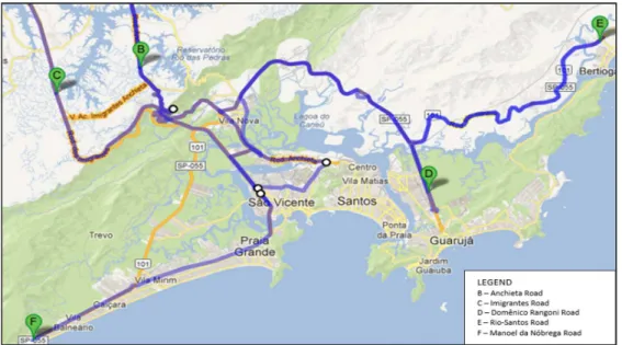
a) Road modal:
It is composed of the following highways:
• Padre Manoel da Nóbrega Highway (SP-055); • Cônego Domênico Rangoni Highway (SP-055),
also known as “Piaçaguera-Guarujá”; • Anchieta Highway (SP-150); • Imigrantes Highway (SP-160);
• Rio-Santos Highway (BR-101)/(SP-055). The BR-101 Highway, also called Coastal
Highway, goes along all the Atlantic coast of Brazil,
with an extension of 4,551.4 kilometers, from Rio Grande do Sul to Ceará. Its access to the port is at
the Rio-Santos stretch, serving the north coast of
the state of São Paulo. At the area from Ubatura to Peruíbe, BR-101 is known as SP-055, allowing the access to the Port of Santos and to the south coast of the state of São Paulo. The Anchieta-Imigrantes System links the capital of São Paulo and countryside
of the state to the coast; the cargo transport through this system is done by the Anchieta Highway and the
rising lane of the Imigrantes Highway. The Cônego Domênico Rangoni Highway connects the Port of
Santos to the Rio-Santos Highway, which is part of
the BR-101/SP-055 system. It is possible to see these access highways to the Port of Santos in Figure 3
(National Agency of Land Transport - ANTT, 2013).
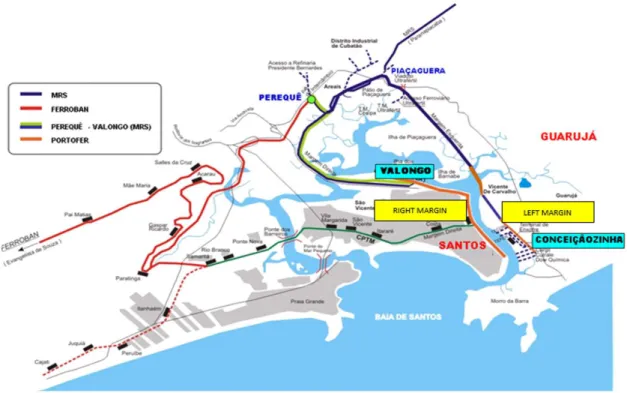
b) Railway modal:
The railway network of access to the port, as seen in Figure 4, is basically managed by two concessionaires: Latin America Logistics (ALL) and
M.R.S. Logistics (MRS). Besides these, a network
from the Metropolitan Trains Company of São Paulo (CPTM) is currently deactivated, which connects FERROBAN to PORTOFER (ALL, 2012).
ALL manages the PORTOFER and Bandeirantes Railways (FERROBAN) networks. The Perequê-Valongo
and MRS networks are concessions of M.R.S. Logistics. As the networks are divided between these two concessionaires, the concessionaire that manages each stretch must provide the right of passage to allow the use of this transportation modal.
c) Waterway modal:
The Tietê-Paraná and Paraguay’s waterways
compose the waterway modal. As the waterways do not present direct connections with the Santos
area, the Port of Santos depends on the intermodal
transportation combining the railway and road modals.
The Tietê-Paraná waterway allows the navigation from Conchas on Tietê River (state of São Paulo) and São Simão on Paranaíba River (state of Goiás) to Itaipu on Paraná River (state of Paraná). Paraguay’s waterway connects ive countries through the Río de la Plata, Brazil, Bolivia, Paraguay, Uruguay, and Argentina. It starts in the city of Cáceres, in Mato Grosso, connecting the Port of Cáceres to the Port of Corumbá/Ladário. It goes through the capital of Paraguay – Asunción – reaching Nueva Palmira at the shore of the Uruguay River (Brasil, 2012).
d) Pipeline modal:
Petrobrás Transports (TRANSPETRO) is a wholly owned subsidiary of Petrobrás and operates in the
transportation and storage of oil, its derivatives, and
natural gas (PETROBRAS, 2012). Inside the Port of
Santos, the cargoes are moved at the Alemoa terminal and on the Barnabé Island.
2.1.1 Local road accesses
According to CODESP (2014d), the Doutor Paulo Bonavides Viaduct, also known as Alemoa Viaduct, is
the main local road access to the right margin terminals
of the Port of Santos. This viaduct connects the end
of the Anchieta Highway to Augusto Barata Avenue,
better known as “Retão da Alemoa”, reaching the right margin of Perimetral Avenue, which extends eight kilometers to “Ponta da Praia”.
Idalino Pinez Street, better known as Adubo Street (“Fertilizer Street”), is the only gateway for
trucks that come from all around the country to load or unload at the several terminals of the left margin
of the Port of Santos. This street received this name for being the main access route to the old Fertilizers Terminal (Tefer) of Guarujá for years, which the private company Fertimpont manages today. Adubo Street, with 1.15 kilometers of extension and 10.5 meters of
width, has three lanes: two for those going towards
the Port of Santos and one for who is leaving it. Adubo Street is accessed via the Cônego Domênico
Rangoni Highway, and it is located between Álvaro
Carmelo Street and José Lourenço Guerra Street, in the municipal district of Guarujá. This street crosses the railway and Santos Dumont Avenue, a lane with heavy local trafic, and gives access to the left margin of Perimetral Avenue, which extends for four kilometers to the district of Vicente de Carvalho.
2.2 Traic congestions on road accesses
According to Resende & Sousa (2009), the term “congestion” does not have a universally accepted
definition; however, a road can be considered congested if the average speed is below its projected
capacity. This deinition is still imprecise because the
perception and expectation regarding congestions
are different for each person. Congestions result in
a set of negative externalities, such as an increase of journey time, emission of pollutants, number of accidents, noise pollution, etc.
The road accesses to the Port of Santos go through
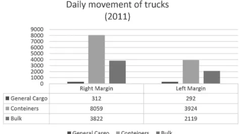
constant congestions due to lines of trucks that try to reach the port terminals for unloading, transforming the road accesses to the maritime terminals into a giant outdoor parking lot. As shown in Figure 5, the
movement of trucks on both margins of the Port of Santos totaled 18,528 vehicles on a single day in 2011.
According to National Transports Confederation - CNT (2012), the reasons for these congestions start
with the lack of storage capacity at the production sites. The exporters of agricultural commodities cannot align the road journeys of their cargoes with the anchoring of vessels on which the cargoes will be loaded. Terminals that schedule the arrivals of trucks are also rare, which makes some vehicles remain
stopped for days, occupying road space. Deicient
planning of port zoning also aggravates congestions, placing the bulk carrier terminals opposite the entrance for trucks, such as the case of soy.
Loading and unloading delays complicate port bottlenecks and help to make lines of trucks at the entrance of terminals that extend along the roads. The regular operation time for a truck at the port
should be three hours, but it can reach 36 hours or
even more. As roads and rails are not physically segregated, road congestions also affect the railway. Trucks usually take all the free space, including rails, hindering or even blocking the passage of trains at
speciic stretches of the port.
According to the ECOVIAS (2012) concessionaire,
the Anchieta-Imigrantes System is also a victim of congestion. The system’s roads are constantly congested with vehicles going towards the port,
ighting for space with other passenger cars, which
are the largest users of the system.
3 Expansion projects and
accessibility studies for the Port of
Santos
With several growth alternatives, one of the Port
of Santos’ main challenges is to plan its expansion based on proposals and studies that point to a horizon of possibilities, demanding a careful analysis of the most adequate actions that guarantee the expansion of the main port system of the country with quality
and eficiency.
The irst version of the Developing and Zone Plan of the Port of Santos (PDZPS) was developed in 1897, when the technical dificulties for the pier
construction with stone walls were overcome, which
had started circa 1890. In 1892, the Dock Company of Santos (CDS) was set up, authorized to expand its installations to Outeirinhos when the irst expansion plans started. Since then, the Developing and Zone Plan of the Port of Santos has been complemented with several projects under CODESP’s responsibility (CODESP, 2014d).
In 2010, CODESP and the Special Secretary of Ports (SEP) of the Brazilian federal government presented the Expansion Plan and Accessibility Study of the Port of Santos, which aimed at directing the growth
of the largest port of Latin America in relation with its
demands until 2024 (CODESP, 2014b). The Expansion Plan characterizes the port scenario from 2009 to
2024, considering the possible executable projects until then and the already consolidated ones, aligned with studies on hinterland demand covering origin and destination markets, main commercial partners,
and global and Brazilian average GDP, among other variables. The study located and deined areas to
install new terminals for containers, bulk solids and
liquids, and passengers, as foreseen in PDZPS, which
indicates the port zone and shows the division of operational areas of the terminal of Santos. The areas
of Conceiçãozinha and Barnabé-Bagres will move
the solid bulk cargoes; the mineral bulk solids will be
moved in Vicente de Carvalho. The liquid bulk cargo
terminals require speed, once the current capacity installed is smaller than the demand for this type of movement. The spaces planned for moving bulk liquids will be located on the islands of Barnabé and Alemoa.
According to CODESP (2014b), all these projects focus on meeting an optimistic projection that the Port
of Santos will move three times more quantity of cargo
until 2024. It will surpass the current 83.2 million tons
to 230 million tons, considering that the general cargo
will be 53% of this volume, bulk solids 30%, and bulk liquids 17%. The quantity of containers moved will also triplicate – from 3.1 million to 9 million TEUs (twenty-foot equivalent unit).
Two expansion projects for the port are already
concluded, the Brazilian Company of Port Terminals (EMBRAPORT) and the Port Terminal of Brazil (BTP). The EMBRAPORT terminal is a venture of Odebrecht TransPort Company to construct and
operate a private port terminal of mixed use at the port’s left margin. The total investment in this new terminal is of approximately R$ 2.3 billion, and
with the conclusion of the irst phase, it is capable of moving 1.2 million TEUs per year. The BPT terminal
received a total investment of R$ 1.2 billion and is
capable of moving 1.2 million TEUs per year, and
1.4 million tons of bulk liquids. In addition to these, investments to optimize and expand other terminals are also foreseen, such as Tecon Santos-Brasil, Libra,
and Right Margin Containers Terminal (TECONDI) estimated to move around 1.9 million, 1.35 million, and 900 thousand TEUs per year, respectively.
In the accessibility studies, part of the Expansion Plan and Accessibilty Study of the Port of Santos (CODESP, 2014d), the necessary conditions were evaluated for the access roads to the Port of Santos
to be properly dimensioned to the growth forecasted to move cargoes, focused on the primary hinterland.
Projects with resources from the Growth Acceleration Program of the Brazilian federal government are in progress and intend to improve the issue of trafic conditions. This is the case of Perimetral Avenue
and the dredging for deepening and widening of the
canal which started in 2009 and 2012, respectively. When totally concluded, they will bring multiple beneits to the Port of Santos, as allowing the access
of larger vessels, in the case of dredging. The project
of dredging for deepening of the pier is already 95%
concluded; the intervention will deepen the canal from
12 to 15 meters and widen it from 150 to 220 meters, allowing the two-way trafic of ships, in addition
to larger vessels, such as the Post-Panamax, with
capacity of 70 thousand tons (CODESP, 2014c). On the other hand, the project to construct and remodel the Perimetral Avenue is limited by the urban
growth. The expansion of the left and right margins of these avenues will meet the already consolidated land uses, as well as the current urban interferences. The project foresees two 10-meter-wide lanes for the
right margin. For the left margin of the Port of Santos, in the municipal district of Guarujá, the project will
focus on solving the problem of access to the port,
eliminating the conlict with the urban environment and connecting Perimetral Avenue to the Cônego Domênico Rangoni Highway without interfering with
the urban area. The accessibility studies also include
a project that foresees improvements in the low of vehicles at the crossing between Adubo Street – main access road to the port’s left margin – and Santos Dumont Avenue. The stoplights that currently operate
with four stages will be reduced to three, and the
direction of the trafic lanes of Adubo Street will be
inverted, which might collaborate to decrease the
slowness of the trafic at the crossing.
Besides these projects, an underwater tunnel will also be constructed, which will connect the left and
right margins of the port through an underground
tunnel, removing the conlict among the urban area,
highway, railway, and important terminal accesses at
the Valongo stretch. In December 2013, the auction
notice to build the tunnel was published, which shall
be concluded in 2018.
In the context of accessibility projects, we must
also consider the Ferroanel project, at the point of
signing the contract between the state and federal governments, and whose implementation shall substantially reduce the port’s dependence on road accesses in the long term. The north stretch of the
Ferroanel will be a priority because it has the largest transportation potential. When concluded, it is predicted to be responsible for 90% of the demand,
according to data from The National Association
of Railway Carriers – ANTF (2014). The projections
state that this stretch will move around 40 million tons of cargo until 2040, 24 million of which will
be headed for the Port of Santos.
4 Data obtained in the ield
Analyzing the expansion projects for the Port of
Santos and their relation with the logistical accesses, we have selected representatives from the companies
acting at the port by convenience. Different points of view of the current port scenario and the dificulties
faced were collected, as well as the expectations after the expansion. The data were obtained through interviews with executives from some of the players at the port, in addition to direct observation and documents
acquired at onsite visits. We used a questionnaire with
open questions for the structured interviews with the executives as an instrument to collect data, applied
from August to October 2012. A representative was
interview from each of the following acting players
at the port: port authority (CODESP), road haulier,
road concessionaire, railway concessionaire, logistics site, and maritime terminal.
Chart 1 identiies the representatives interviewed
from each player:
a) CODESP
The Dock Company of the State of São Paulo (CODESP) is a mixed-activity holding company linked to the Special Secretary of Ports of the Brazilian
Chart 1. Representatives from the interviewed players.
Player Position or Function
CODESP Advisor to the Presidency Road haulier Operations Coordinator Road concessionaire Operations Manager Railway concessionaire Communication Counselor Logistics site Operations Manager Maritime terminal General Manager
federal government. It plays the strategic role of port administrator and port authority, looking after the development and inspection of rental contracts.
It also intends to prepare the Port of Santos for a substantial boost in the low of cargoes, implementing
administrative measures, aiming at providing the port with adequate planning to allow its expansion.
CODESP is responsible for managing 42 of the 56 terminals of the Port of Santos, while private
companies manage the rest of them.
During a visit to CODESP in September 2012, accompanied by the advisor to the Presidency, we
could obtain a broad view regarding the logistical
accesses of the Port of Santos, the world’s largest
exporter of sugar and or orange juice. According to
the interviewee, the excess in the low of trucks at the commercial period intensiies as trains that pass
through the same line from the passengers of the
city of São Paulo are released for circulation only
at the night time, thus decreasing the quantity of cargoes that can be drained by the railway modal.
As manager and port authority, CODESP highlights
some reasons that restrict the working hours of the
port, making it impossible to have a better eficiency
at the waiting time of the cargoes at the terminals.
One of the main reasons is the decrease of inspection operations (Aduana, Agriculture, and ANVISA), which
operate with a reduced workforce outside business
hours. According to CODESP, one action that would
help to drain the cargoes is the release of containers under a customs transit system, which would allow to transfer cargo to a customs precinct closer to the importing company. The static capacity of the terminals is impaired partially due to the importers’ slowness to unload the cargoes, which is a result of
lack of storage in their installations or inancial cash low. Added to this is the large number of cargoes lost
for several months or even years due to the lack of inspectors to conduct a sanitation and the necessary bureaucratic process to bring the auction to fruition,
which also hampers the cargo outlow.
b) Highway concessionaire
It is the concessionaire responsible for managing
the 176.8 kilometers of road extension that compose
the Anchieta-Imigrantes System, which is the main
connection between the metropolitan area of São Paulo and the Port of Santos. With an average low of
2,000 vehicles per hour, which can reach up to 12,000 vehicles per hour on peak days, the Anchieta-Imigrantes System is composed of the following highways:
SP-150 (Anchieta Highway), with 55.9 kilometers; SP-160 (Imigrantes Highway), with 58.54 kilometers; SP-040/150 (Planalto Interconnection), with 8
kilometers, connecting the Anchieta and Imigrantes
Highways at the top of the Mountain range; SP-059/150 (Santos area Interconnection), with 1.8 kilometers of
extension; SP-248/55 (Cônego Domênico Rangoni Highway, better known as “Piaçaguera-Guarujá”), with 30.6 kilometers; and SP-055 (Padre Manoel da Nóbrega Highway), with 21.6 kilometers of extension.
The concessionaire responsible for the Anchieta-Imigrantes System, visited in September 2012, manages ten lanes that connect these two regions, four of them on Anchieta and six on the Imigrantes Highway. According to the concessionaire’s operations manager, this system is the only in Brazil that operates with the possibility of reversal of lanes, easily adapting to
low variations. An average of 90,000 cargo vehicles
and passenger cars use these highways every day; however, many of them use untolled urban areas. Approximately 12,000 of these are commercial and cargo vehicles, considering only the trucks taxed at toll stations. The representative interviewed from the
concessionaire stated that the maximum low that
the system can absorb is 12,000 vehicles per hour; however, the bottlenecks generated at the entrances
of the destination cities have made the maximum low
to be 10,000 vehicles per hour so far. The total gross
weight allowed in the system is 45 tons per axle, and
the concessionaire is responsible for operating the scales to verify the load. The Anchieta-Imigrantes System’s administrator obtained a 20-year concession
in 1998; however, this period was extended for ive
more years due to the inclusion of a new project
to build a clover at Kilometer 55 of the Anchieta Highway, amplifying the accesses to the Cônego Domênico Rangoni Highway, and thus to the port’s
left margin.
According to the concessionaire, the
Anchieta-Imigrantes system is able to absorb the low increase due to the expansion of the Port of Santos; however,
it was highlighted that despite the structures of the
Imigrantes Highway withstanding the trafic of heavy vehicles, there is a prohibition that meets Ordinance 11/2002 from São Paulo State Transport Regulatory Agency – ARTESP (2002), Decree Number 46708,
and prevents the transit of heavy vehicles on the
descending lane of the Imigrantes Highway SP-160.
The law considers the age and average level of
damage of the heavy vehicle leet (trucks, trailers, and
semi-trailers), dual use vehicles and passenger cars (minibuses, vans, and buses), taking into consideration the study developed by the National Association
of Motor Vehicle Manufacturers - ANFAVEA and its afiliated companies under the effect known as “fade” – overheating of brakes that occurs in vehicles
equipped with drum brakes. The study concluded that the circulation of these vehicles on the descending lane of Imigrantes would be temerarious in virtue of
a signiicant risk of eficiency loss of the brakes due to an inclination of approximately 6% of the ramp
coastal mountains, characterizing a relevant limitation
to the low of heavy vehicles in the system and at the
access to the port. The decree is also applied to the ascending lane in case it is being used as descending.
c) Railway concessionaire
With over 21,300 kilometers of railway network and a direct connection with the Port of Santos, the
concessionaire links the Santos region to the cities of
Santa Fé do Sul, Panorama, and Colômbia through a
segment of approximately 3,000 kilometers of railway lines, draining the production from the states of Mato
Grosso, Mato Grosso do Sul, and São Paulo by means of the São Paulo railway network, granted until 2028.
The company, which was visited in November 2012, executes the largest part of the railway transportation
of cargoes at the Port of Santos through the network known as PORTOFER.
The executive interviewed highlights that there is a huge restriction to the railway modal at the port due to different network concessions and the need for requesting the right of way at sections from other concessionaires. Besides, the network accesses to the port only allow one train to pass at a time, totaling
a maximum of 18 trains per day that enter or leave
the port, or approximately 1,120 wagons per day in 2011 taking into consideration the trains from all concessionaires. Most of these compositions transport
bulk cargo, unloaded from the trains at one of the ive hoppers available at the Port of Santos. In some cases,
this process is slow with approximately 3 wagons per hour, resulting in a bottleneck in operation. The rest of the compositions is loaded from containers and is usually managed by logistics operators due to customs procedures.
In order to increase the low of cargoes entering and
leaving the port through railways, the concessionaire works with intersection sites at some strategic
segments of its network, minimizing the dificulty
of the single rail and enabling the passage of a train while another one awaits at this yard according to the prioritization of the railway concessionaires. Aiming at increasing the participation of the railway modal to drain cargoes at the port, the concessionaire in
partnership with CODESP is developing a project to duplicate the rails at the Campinas-Santos segment with resources from the Growth Acceleration Plan from the Brazilian federal government. The irst stretch between Perequê and Cubatão has already been concluded, which allowed to increase from 30 to 60
the number of wagons in daily circulation at the port’s right margin. The project, which has been executed by
stretches, foresees the duplication of 383 kilometers of railways from Campinas to Santos, and will enable the removal of approximately 1,500 trucks from the
highways.
Another project that the interviewee mentioned
was the restructuring of the PORTOFER network
at the right margin stretch. The rail currently goes through some maritime terminals, hampering the operation for trains and trucks that will unload or load their cargoes. The trucks waiting for release from the terminal often remain on the rails, blocking the
passage of the trains and slowing down the eficiency
of both modals. According to the interviewee, it is expected that the use of the railway modal match the road modal until 2024 with the implementation of the scheduled projects.
d) Road haulier
It is the largest provider of integrated and customized
logistics services of the country, with over 90 branches, a leet of approximately 12,000 trucks and
a workforce of 20,000 employees. The company has branches strategically located to support ports, which allows it to experience everyday problems related to
road accesses. The branch, visited in October 2012, is strategically located in Cubatão, facilitating the access of its vehicles to the areas of the Port of Santos.
The haulier uses previous schedule to load or unload containers whenever it is possible, thus avoiding vehicles to remain at the port’s proximities without need. Scheduling is not available for bulk cargo, resulting in lines of trucks, especially during the harvesting season. The haulier’s operations coordinator mentioned that one of the factors which
cause a huge impact on the low of vehicles in the logistics system as a whole is the trafic of empty
containers. The containers must be returned to the area intended for storing empty containers at the places recommended by the owners at port areas
after delivering the cargoes to their inal destinations.
In order to improve this return operation, the haulier is developing a strategy with the owners to decrease the number of journeys with empty containers, reloading the trucks whenever possible with cargoes from companies that are located near the area where the material coming from the port was unloaded. The haulier’s representative reports that the access
to the port’s left margin by Idalino Pinez Street, also
known as Adubo Street, is a critical point for their operation, and they consider this the main bottleneck
in the road access system to the Port of Santos.
e) Maritime terminal
The maritime terminal visited is responsible for loading and unloading operations of containers and general cargo, providing operational facilities for customs transit, in addition to other port activities.
It has a total area of 155,000 m2-105,000 m2 consist of
a customs terminal with a 1,085-meter pier extension
approximately 800,000 TEUs in 2011, representing 27% of market share.
Following the expansion projects that the Port
of Santos has been going through, the terminal
visited in October 2012 will receive an investment of approximately R$ 550 million with the intention
of remaining competitive and supplying the growth for the demand forecast. It foresees an expansion
of 115,000 m2 of customs area, increasing its static
capacity from 13,600 to 22,500 TEUs. According to
the terminal’s general manager, the capacity of road accesses that will drain the received and dispatched cargoes causes great concern with the growth of the
movement capacity of the Port of Santos. This situation is intensiied during the grain harvesting season,
especially soy, which is prioritized at the port due to governmental exportation regulations, increasing the cargo movement at this period. The soy grains are completely transported in bulk by means of road and railway modals. Besides the harvest peak, the movement of general cargo tends to increase during the last trimester of the year due to the holiday season. As an alternative, the company aims at developing multimodality each time more, using for instance
the railway modal. Currently, the company moves approximately 150 containers per journey every
week at this modal, with a established itinerary. Its restrictions are low train speed when compared with the road modal, and the division of railway lines among different concessionaires, resulting in the need for authorizations for passage.
The long period to release the cargoes through the
Brazilian customs – around 48 hours – is one of the
factors highlighted that interfere in the movement
capacity of containers, and consequently in the low of
heavy vehicles inside and outside the terminals. In order to minimize customs impacts, the terminal created dry ports, which allow the cargoes to undergo their clearance out of the organized port. The interviewee mentioned a possible solution for the congestion of trucks waiting for the entrance at the port which would be the need for using tags linked to the port scheduling system, allowing vehicles heading for the port only to be released at toll stations at the Anchieta-Imigrantes System when authorized.
f) Logistics site
The logistics site makes services available to support all the logistics chain. It encompasses integrated logistics, storage, foreign trade, transports, and
information focused on the eficacy of operational
processes and in solid partnerships with clients and
collaborators. With approximately 440,000 m2 of total area, 140,000 are destined for the yard to park trucks
heading for the Port of Santos, whether it be for the
loading or unloading of cargoes, thus decreasing the quantity of trucks at the areas around the port while
they wait for the release to unload or for the vessel to berth. According to information obtained during the interview in September 2012, the logistics site
offers 650 oficial parking places for trucks to wait
for the scheduled time to access the port, this way doubling the number of places in order to meet the demand, using areas that would be intended for other services. This area destined for the parking of trucks helps to decrease the number of vehicles awaiting at the port’s entrance to load or unload. The site has a
contract with some companies, including Copersucar, Bulk Terminal of Guarujá - TGG, and Cosan. In these
cases, the logistics yard itself is responsible for
contacting the port for scheduling. For sporadic
trucks, i.e. those that do not belong to one of the client companies, the only service provided at the site is parking. Through partnerships with some owners, the logistics site makes an area available for storing empty containers, ensuring that some road hauliers do not need to remove or return these containers to port areas, also with a yard destined for repairing these empty containers. This way, even if a breakdown is present, they do not need to return to the port area in order to be able to circulate again.
The representative also informed that the site offers
customs clearance services, such as Special Place for Exportation Customs Clearance - REDEX, which
is a place where cargoes destined for exportation go through customs clearance and are regulated by
the Brazilian Federal Revenue Ofice. A new area
is also under construction which will be destined for a logistics and customs center, infrastructure to facilitate and rationalize the movement of importation
and exportation lows. These two services directly
assist in increasing the static capacity of maritime terminals because they are able to redirect the volume that would be awaiting at the terminal to undergo customs clearance, as well as decentralizing the arrival and departure of cargoes nearby the port.
According to the interviewee, the area destined for full containers operates as a warehouse. The trucks bring their cargoes, and the containers are loaded or already come to the site loaded, then await for the availability of vessels for boarding. This process facilitates the loading of vessels because the site is strategically located for this transportation to happen fast when solicited.
5 Consolidation and discussion of
results
The analysis of data obtained in the ield allowed us to identify several causes for the access dificulties to the Port of Santos, which were classiied into four
distinct groups in order to facilitate understanding and systematize possible improvement actions. Among
restrictions to the railway modal, misuse of the capacity of the maritime terminals, and congestions at the accesses.
More than one of the players interviewed highlighted many of these causes, which reinforces the credibility of the table obtained. Chart 2 consolidates these data:
Besides structural projects that demand larger scale investments, such as the ones foreseen in the
Expansion and Accessibility Plan of the Port of
Santos, we could identify a series of administrative
actions that could improve the eficiency of several
port processes. In addition to these, we also found smaller scale projects that could improve access logistics that are either already in progress or could be started relatively fast to minimize the limitations that the access system imposes for the port’s expansion.
On the one hand, administrative and/or regulatory
actions, such as previous scheduling for loading and unloading and the implementation of dry ports,
could minimize the low dificulties at port areas and
the misuse of the capacity of maritime terminals.
Production engineering tools, such as modeling and
simulation, in addition to operations management and organizational engineering concepts, could be useful in the project and implementation of these actions.
On the other hand, restrictions for the railway modal and congestions at accesses are dificulties whose
causes are structural, and therefore demand investments in larger scale projects, as the restructuring of the railway network and the construction or remodeling
of Perimetral avenues. We could identify the existence of several projects coordinated by CODESP regarding the Expansion and Accessibility Plan of the Port of
Santos aiming at improving its accesses based on
the estimates of low increase until 2024. Important
projects are in the process of being procured, such as the construction and remodeling of stretches of
the Perimetral Avenue at the port’s right margin. At the left margin, the irst stage of implementation of the Perimetral Avenue was concluded, including
the completion of a set of viaducts that eliminated the last road bottleneck in the region, ending the
road-railway conlict. A project to create new accesses
to the terminals at the left margin is also in progress, as an option for the only access we have today, which is Adubo Street.
We could also verify the concern from the players
involved in this research to plan and execute their own alternatives to adapt themselves to the current conditions and minimize the growth impacts of the
port activity. The classiication of the several causes identiied for the access dificulties to the Port of
Santos, proposed in Chart 2, contributes to better understand the problem on the part of the managers from these players, and also to systematize possible improvement actions in order to make them more
effective. We also believe that the classiication
proposed represents the initial basis to build a theoretical model that facilitates the development of a new research on this theme.
Chart 2. Consolidation of the research results.
Consolidation of the research results
Causes Group Actions
✓ Trafic of empty containers;
✓ Lack of availability to schedule bulk cargo.
Dificulty of low at port areas
✓ Previous schedule for loading and unloading;
✓ Implementation of sites to store empty containers;
✓ Reloading of containers close to the destination areas;
✓ Use of regulatory sites.
✓ Railway lines divided by different concessionaires;
✓ Slowness from hoppers to unload wagons;
✓ Interference from the PORTOFER railway network with road accesses.
Restrictions to the railway
modal
✓ Duplication of the rails at the Campinas– Santos access network;
✓ Restructuring of the PORTOFER network at the right margin;
✓ Implementation of sites to cross compositions.
✓ Slowness to release cargoes at customs;
✓ Slowness by hauliers to unload cargoes;
✓ Lost containers;
✓ Restrict working hours of the inspection agencies.
Misuse of the capacity of the maritime
terminals
✓ Release of containers in customs transit system (Dry Port);
✓ Rationalization of the importation/exportation low;
✓ Customs clearance at the sites.
✓ Bottlenecks at the local accesses to the port, “Adubo Street”;
✓ Trafic restrictions for heavy vehicles at the descending lane of the Imigrantes Highway;
✓ Interferences with urban trafic;
✓ Lack of physical segregation between roads and railways.
Congestions at the accesses
✓ Construction of the clover at Km 55 of the Anchieta Highway.
✓ Revamping of “Adubo Street”;
✓ Construction or remodeling of the Perimetral Avenues at the right and left margins.
References
Agência de Transporte do Estado de São Paulo – ARTESP. (2002, 7 de dezembro). Portaria 11/2002. Regulamenta o Tráfego de Veículos de Carga (Caminhões, Reboques e SemiReboques), Veículos Mistos e Veículos de Transporte de Passageiros (Microônibus e Ônibus) na Pista Descendente da Rodovia dos Imigrantes SP-160. São Paulo, SP: Diário Oficial do Estado de São Paulo. Recuperado em 6 de março de 2014, de http://www. artesp.sp.gov.br/legislacao-portarias-page=22.html Agência Nacional de Transportes Ferroviários - ANTF.
(2014). Recuperado em 6 de março de 2014, de www. antf.org.br/
Agência Nacional de Transportes Terrestres - ANTT. (2013). Recuperado em 10 de janeiro de 2013, de www.brasil. gov.br/sobre/turismo/entidades/agencia-nacional-de-transportes-terrestres-antt
América Latina Logística - ALL. (2012). Index. Recuperado em 1 de novembro de 2012, de www.all-logistica.com/ port/index.htm
Barco, R. F. (2012). A importância da integração de modais para o funcionamento do Porto de Santos. Recuperado em 22 de setembro de 2012, de http://www. portodesantos.com.br/apresentacoes.php
Barco, R. F. (2014). Caos logístico regional: o polo, o porto e as cidades não podem parar. Recuperado em 24 de março de 2014, de http://www.unaeventos.com. br/megapolo/2013/palestrasmegapolo/renatobarco.pdf Berger, A., & Berger, F. R. (2009). Portos e terminais
marítimos do Brasil (2. ed.). Joinville: Bela Catarina. Brasil. Ministério dos Transportes. (2012). Conceitos
hidroviários. Recuperado em 10 de outubro de 2012, de www.geipot.gov.br
Brito, T., & Botter, R. C. (2012). Uma discusión acerca de las condiciones de acceso terrestre a los terminales del Puerto de Santos y su importancia para el mantenimiento de la competitividade portuária. In Actas de la Conferencia SYMMTECHNAVAL 2012 (Vol. 1, pp. 1).
Companhia Docas do Estado de São Paulo - CODESP. (2014a). Análise do movimento físico do Porto de Santos. Recuperado em 24 de março de 2014, de http://www. portodesantos.com.br/estatisticas.php
Companhia Docas do Estado de São Paulo - CODESP. (2014b). Porto de Santo: projetos e investimentos. Recuperado em 24 de março de 2014, de http://www. portodesantos.com.br/mercado.php?pagina=04 Companhia Docas do Estado de São Paulo - CODESP.
(2014c). Panorama do Porto de Santos. Recuperado em 24 de março de 2014, de www.portodesantos.com.br Companhia Docas do Estado de São Paulo - CODESP.
(2014d). Plano de Desenvolvimento e Zoneamento do Porto de Santos. Recuperado em 24 de março de 2014, de www.portodesantos.com.br/documentacao.php
6 Conclusions
The Port of Santos – the largest port of Latin
America and responsible for the majority of the
Brazilian international trade – has been suffering with the expansion of the low of goods largely due
to lack of infrastructure of logistics access network. This study aimed at investigating which are the
causes for access dificulties to the Port of Santos,
and it also intended to identify the ongoing actions and scheduled projects to adequate these accesses to the expansion of the movement of the port, which were fully accomplished.
We executed this study by means of exploratory
research, involving interviews with executives and in loco visits to different acting players at the port, as well as analyzing secondary data obtained from
CODESP’s website, port authority and managing body of the Port of Santos.
The data obtained allowed the identiication of several causes for the access dificulties to the port, which were classiied into four distinct groups: dificulties of low at port areas, restrictions to the railway modal,
misuse of the capacity of maritime terminals, and
congestions at the accesses. The authors also veriied that access dificulties to the Port of Santos are not
only caused by structural issues, but also by a lack of
eficiency from several port processes that could be minimized through administrative actions and/or the implementation of new regulations. We could identify
possible necessary actions to mitigate these problems, some of which have already been implemented, while others are in the process of being procured or at project stage. The holistic view of the current scenario of
access dificulties to the Port of Santos obtained with
this work indicates that these actions may be enough to reestablish the balance between the port system’s capacities and the access modals in the long term.
The classiication presented for the several causes of access dificulties to the port contributes to better
understand the problem on the part of the managers involved with port operations, and it can also serve as a basis to develop new researches of this subject.
With the existence of several public and private
organizations involved with different improvement projects already in progress, the role of the coordination
of CODESP as port authority and managing body of the Port of Santos is fundamental.
Liu, X., Zhao, B., Li, B., & Wang, N. (2010). A system dynamics model of the interaction between port and city based on the green concept. In Proceedings of the International Conference of Logistics Engineering and Management, Chengdu, China. ASCE Library. Recuperado em 24 de novembro de 2012, de http:// dx.doi.org/10.1061/41139(387)95
Ornellas, R. S. (2008). Relação Porto/Cidade: o caso de Santos (Dissertação de mestrado). Departamento de Geografia, Faculdade de Filosofia, Letras e Ciências Humanas, Universidade de São Paulo, São Paulo. PETROBRAS. (2012). Principais subsidiárias. Recuperado
em 20 de outubro de 2012, de www.petrobras.com.br/ pt/quem-somos/perfil/principais-subsidiarias/ Resende, P. T. V., & Sousa, P. R. (2009). Mobilidade urbana
nas grandes cidades brasileiras: um estudo sobre os impactos do congestionamento. In Anais do 12° Simpósio de Administração da Produção, Logística e Operações Internacionais, São Paulo. São Paulo: FGV-EAESP. Silva, F. G. F., & Rocha, C. H. (2012). A demand impact
study of Southern and southeastern ports in Brazil: an indication of port competition. Maritime Economics & Logistics, 14(2), 204-219. http://dx.doi.org/10.1057/ mel.2012.4.
Silva, G., & Cocco, G. (1999). Cidades e portos: os espaços da globalização. Rio de Janeiro: DP&A.
Song, D.-W., & Yeo, K.-T. (2004). A competitive analysis of Chinese container ports using the analytic hierarchy process. Maritime Economics & Logistics, 6(1), 34-52. http://dx.doi.org/10.1057/palgrave.mel.9100096. Vilas Boas, S. (2005). Santos: o centro histórico, o porto
e a cidade. São Paulo: Audichromo. Confederação Nacional do Transporte - CNT. (2012). Boletim
estatístico. Recuperado em 30 de setembro de 2012, de www.cnt.org.br/Paginas/Boletins_Detalhes.aspx?b=3 Daamen, T. A., & Vries, I. (2013). Governing the European
port-city interface: institutional impacts on spatial projects between city and port. Journal of Transport Geography, 27, 4-13. http://dx.doi.org/10.1016/j. jtrangeo.2012.03.013.
Ecovias. (2012). Institucional Sistema Anchieta Imigrantes. Recuperado em 3 de outubro de 2012, de www.ecovias. com.br/Institucional/Sistema-Anchieta-Imigrantes
Google Maps. (2012). Rodovias de acesso ao Porto de Santos. Recuperado em 12 de outubro de 2012, de https://www.google.com.br/maps/dir/Rod.+Anchieta/ Porto+de+Santos+-+Porto+Ponta+da+Praia,+SP/Rod.+dos+ Imigrantes,+S%C3%A3o+Paulo/-24.0030983,-46.2716712/ Rod.+Rio-santos/Rod.+Padre+Manoel+da+N%C3% B3brega/@-23.9338433,-46.4246089,11z/data=!4m3 3!4m32!1m5!1m1!1s0x94ce43a6bf9d7739:0x412f0 e87c8d6701!2m2!1d-46.568182!2d-23.681241!1m5 !1m1!1s0x94ce0218fc056a8f:0x64d06dbf47d69d70 !2m2!1d-46.292606!2d-23.982228!1m5!1m1!1s0x 94ce3fe43434cc51:0xa468188353173bee!2m2!1d-46.5825075!2d-23.8195227!1m0!1m5!1m1!1s0x94ce07 47dc38878b:0x6916fb953f639302!2m2!1d-46.2269!2d-23.89!1m5!1m1!1s0x94d02851190b3de9:0xd409b7 684e2a7d7f!2m2!1d-46.948499!2d-24.262293!3e0. Haralambides, H., & Gujar, G. (2012). On balancing supply