THE ANALYSIS OF LAND USE BASED ON CORINE LAND COVER IN
THE ROMANIAN PART OF THE TISA CATCHMENT AREA
RAULARIAN RUSU
1, TITUS MAN
2, IOAN FODOREAN
3, CIPRIAN MOLDOVAN
4ABSTRACT - The analysis of the land use structure of the 13 counties of the Romanian part of Tisa catchment area has been made according to the 2000 edition of CORINE Land Cover, while the 1990 edition has been used for comparative purposes. Out of the total area of 8,269,229.48 hectares, the forests cover 37.92%, the arable lands 35.02% and the grasslands 17.97%. The other types of land use have lower weights, such as the continuous and discontinuous urban fabric 4.81%, the orchards 1.10% and the vineyards 0.98%. In the category of forests, the following types of land use are included: broad-leaved forests, which form the majority (24.72%), coniferous forests (6.22%), mixed forests (3.46%) and transitional woodland-shrub areas (3.52%). The forests are mainly located in the Carpathians and the hills. The non-irrigated arable lands (23.50%) are predominant within the arable lands. They lie mostly in the Western Plain and in the basins and corridors of the Transylvanian Depression and the Western Hills. The analysis of the dynamics of the land use structure between 1990 and 2000 indicates a relative stability in the case of forests, a decrease of arable lands and an increase of grasslands.
Keywords: land use, CORINE land cover, Tisa catchment area, forests, arable lands, grasslands
The analysis of the land use structure at the level of the 13 counties of the Romanian part of Tisa catchment area has been performed taking into account the data of the 2000 edition of CORINE Land Cover. The data of the 1990 edition of CORINE Land Cover have been used for comparative purposes and in order to highlight a certain territorial dynamics.
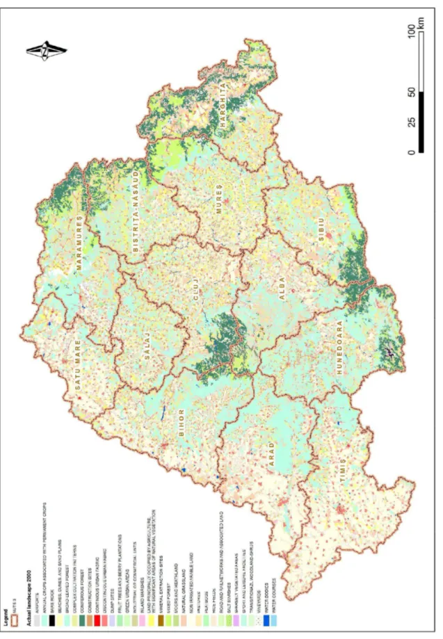
According to the 2000 edition of CORINE Land Cover classification, there are 30 different types of land use across the 13 analysed counties. Of these 30, only 11 types have a weight of over 1% of the analysed territory.
In absolute numbers, considering the total area of 8269229.48 hectares, the broad-leaved forests cover 24.72% (2044090.76 ha), the non-irrigated arable land – 23.50% (1943361.18 ha), the secondary grasslands or pastures – 16.48% (1362832.49 ha), the land principally covered by agriculture, with significant areas of natural vegetation – 6.62% (547249.07 ha), the coniferous forests – 6.22% (514692.44 ha), the complex cultivation patterns – 4.91% (405584.66 ha), the discontinuous urban fabric and rural built-up areas – 4.79% (395874.85 ha), the transitional woodland-shrub areas (young forests and cleared areas) – 3.52% (290775.58 ha), the mixed forests - 3.46% (285781.51 ha), the natural grasslands – 1.49% (123061.28 ha), and the fruit trees and berry plantations (orchards) – 1.10% (90683.77 ha). All the other types of land use totalize together 3.21%. The most important of them are the vineyards (0.98%), the marshes (0.69%), the industrial or commercial units (0.45%), the moors and heathland (0.38%), the water courses (0.27%), the water bodies (0.18%), the sparsely vegetated areas (0.07%), the mineral extraction sites (0.05%). The other land uses (airports, dump sites, beaches, dunes and sand plains, road and rail networks and associated lands, continuous urban
1
Assistant Professor, PhD, Babe -Bolyai University of Cluj-Napoca, Faculty of Geography, 5-7 Clinicilor Street, 400006 Cluj-Napoca, Romania. E-mail: [email protected], [email protected] 2
Assistant Professor, PhD, Babe -Bolyai University of Cluj-Napoca, Faculty of Geography, 5-7 Clinicilor Street, 400006 Cluj-Napoca, Romania. E-mail: [email protected]
3
Assistant Professor, PhD, Babe -Bolyai University of Cluj-Napoca, Faculty of Geography, 5-7 Clinicilor Street, 400006 Cluj-Napoca, Romania. E-mail: [email protected],
4
RAULARIAN RUSU, TITUS MAN, IOAN FODOREAN and CIPRIAN MOLDOVAN
fabric, bare rock, rice fields, peatbogs, sport and leisure facilities, construction sites and green urban areas) have very low weights and usually are not present in all the analysed counties.
For instance, peatbogs may be found (covering a very small area) only in Harghita County. Beaches, dunes and sand plains are present only in Arad and Hunedoara counties, while rice fields exist only in Arad, Bihor and Timi counties. Surprisingly, according to CORINE Land Cover database, there are no road or rail networks in the counties of Bihor, BistriŃa-Năsăud, Hunedoara, Maramure , Mure , Sălaj and Sibiu, while their weight is extremely low in the other counties. It comes out that CORINE database has serious shortcomings in registering certain linear types of land use. The water courses represent a similar case, as they are, for instance, completely absent in Harghita County according to this database. At the same time, one may be surprised by the higher weight of the marshes compared to the water bodies (lakes).
It is noticeable that three types of land use cover most of the territory, by far: the forests, the
arable lands and the grasslands.
The four land uses, which may be grouped together as “forests”, are: the broad-leaved forests, the coniferous forests, the mixed forests and the transitional woodland-shrub areas (including young forests and deforested areas). Together, they amount to 37.92% of the total analysed area. Without the human intervention, accelerated in the latest centuries, the forests would cover naturally more than 80% of the territory, except for the steppe grasslands of the Romanian Western Plain and the heath and moorlands of the highest mountain areas in the Carpathians (Conea, 1984, Csucsuja, 1998, Giurescu, 2004). As result of the deforestation, especially in the Transylvanian Depression and the Western Hills and Plain, the weight of the forests declined constantly (Popescu, 1985, Teoran, Groza, 2004, Ungur, 2008). Nowadays, forests are present significantly only in the mountain areas and in some parts of the Transylvanian Depression and the Western Hills (Pop, 2001, Rusu, 2004, Pop, 2005, Cocean, 2009, Cocean, 2010).
As a consequence of the location of Romania in the nemoral area, and of the rather low altitudes of the mountain areas situated in the Romanian part of Tisa catchment area, the broad-leaved
forests have the highest weight (24.72%). Within these forests, the dominant species is beech,
especially at average heights in the Carpathians, followed by pedunculate oak and sessile oak, at lower altitudes, generally at the base of the mountains and in the hills and plateaus. One may add other species, like the hornbeam, the ash, the maple, the Turkey oak and the Hungarian oak (Ghi a, Tudoran, Coldea, 1971, ChiriŃă, 1981, Pop, 2006).
The analysis of the distribution by counties indicates high weights of the broad-leaved forests in the counties with important mountain areas. Hunedoara County comes first with 44.10%, especially due to the presence of lower mountains – Metaliferi, Poiana Ruscă, but also the higher ones - Bihor, ureanu, Retezat, Parâng and Vâlcan Mountains, well covered by deciduous forests on their lower slopes. The classification continues with Arad County – 31.41% (due to Zărand, Codru-Moma, Bihor and Metaliferi Mountains), Sălaj County - 31% (in Mese and Plopi Mountains, but also in the Western Hills and Some an Plateau) and Maramure County – 30.79% (in Gutâi and łible Mountains, and in the lower half of Maramure and Rodna Mountains). The lowest weights of the broad-leaved forests are registered in Harghita County (9.01%), where coniferous forests are predominant, and in Timi County (13.60%), which is mainly agricultural. In all the other counties, the broad-leaved forests cover between 19% and 29% of the territory.
The coniferous forests (6.22%) cover lands above 1200-1400 m, up to 1600-1800 m, only in
F
ig
u
re
1
.
T
h
e
la
n
d
u
se
s
tr
u
ct
u
re
i
n
t
h
e
R
o
m
a
n
ia
n
p
a
rt
o
f
T
is
a
c
a
tc
h
m
en
t
a
re
a
RAULARIAN RUSU, TITUS MAN, IOAN FODOREAN and CIPRIAN MOLDOVAN
High weights of the coniferous forests are also registered in the counties of BistriŃa-Năsăud – 10.25% (in Rodna, Suhard and Călimani Mountains), Sibiu 9.59% (in Făgăra , Cindrel and Lotru Mountains), Cluj 9.53% (in Bihor, Vlădeasa and Muntele Mare Mountains), and Maramure 9.32% (in Rodna, Maramure and łible Mountains). The lowest weights, under 0.1%, are found in the western counties, Timi , Arad, Satu Mare and Sălaj, where there are no high mountains.
The mixed forests represent those woodland areas, located usually between 1000 and 1400 m
high, where the coniferous species are mixed with beech (Ardelean, 1999, Pop, 1978, Pop, 2006). At the level of the entire analysed territory, their weight is only 3.46%. Higher values, between 7 and 9%, are characteristic for the counties with higher weights of coniferous forests: Harghita (9.44%), Maramure , BistriŃa-Năsăud, as well as Mure County (9.08%). Weights below 0.1% may be found in the same four western counties, already mentioned in the case of coniferous forests: Timi , Arad, Satu Mare and Sălaj.
The category of transitional woodland-shrub areas (including young forests and cleared lands) generally regards those areas located at the upper limit of the forest, characterized by the presence of isolated trees, mixed with shrubs, especially mugo pine and juniper. This type of vegetation, which amounts to 3.52% of the total area, is also present in those counties that have a high weight of the coniferous forests: Harghita 9.69%, Maramure 7.32%, Sibiu 4.99%. The percentage is above 1% in all counties, even those located in the West, without high mountains; therefore one should take into account the inclusion of deforested areas with shrubs in this category.
From the point of view of the area covered, the second largest type of land use is represented
by arable lands which, together with the complex cultivation patterns and the mainly agricultural
lands, with significant areas of natural vegetation, reach 35.02% of the territory.
Most of these lands are included in the category of non-irrigated arable lands (23.50%). The main crops are: cereals (mainly wheat and maize), industrial crops (sugar beet, sunflower, flax, hemp and others), potatoes, vegetables (Păcurar, 1998, Kakucs, 1998, Surd, 2002, Kovacs, 2005).
These lands are mainly located in the Western Plain, as well as in the basin and corridor areas of the Transylvanian Depression and the Western Hills (Pop, 2001, Rusu, 2004, Pop, 2005).
Therefore, the highest weight of non-irrigated arable lands is recorded in Timi County (56,26%), where the plain is the predominant landform, followed by the counties of Satu Mare (43.90%), Arad (37.99%) and Bihor (30.69%), all characterized by the presence of the Western Plain. The lowest weights, below 10%, are registered in the mountainous counties - Hunedoara (6.20%), Maramure (7.22%) and Harghita (8.41%). All the other counties, situated in the Transylvanian Depression, have weights between 11% and 23%, slightly below the average of the analysed territory.
The lands with complex cultivation patterns are predominantly found in the hilly areas, representing scattered arable lands, with small-size parcels and diverse uses. Within the analysed territory, they cover 4.91%. They are most frequent in the counties of Sălaj (9.70%), Cluj (8.90%), Alba (6.94%) and BistriŃa-Năsăud (6.60%). On the contrary, the lowest weights are registered in Timi (1.24%), Sibiu (1.65%) and Arad (2.70%). In all the other counties, the complex cultivation patterns cover between 3% and 6% of the county area.
The mainly agricultural lands, with significant areas of natural vegetation, represent
6.62% of the total analysed area. Largely, this category includes those lands that have been used in agriculture (especially arable lands), which however remained partly uncultivated, either because of a crop rotation system or as a result of abandonment. In the latter case, the land tends to go back to its natural state. The vegetation which partly replaces the crops is represented by herbaceous and woody species. By counties, higher weights of these lands are registered in Sibiu (12.63%), Mure (12.36%) and BistriŃa-Năsăud (11.08%). They are less represented in the counties of Hunedoara (2.82%), Arad (3.36%) and Alba (3.48%). In all other counties, these lands cover between 4% and 10%.
E
A
N
A
L
Y
S
IS
O
F
L
A
N
D
U
S
E
B
A
S
E
D
O
N
C
O
R
IN
E
L
A
N
D
C
O
V
E
R
I
N
T
H
E
R
O
M
A
N
IA
N
P
A
R
T
O
F
T
H
E
T
IS
A
C
A
T
C
H
M
E
N
T
A
R
E
A
5
1
RAULARIAN RUSU, TITUS MAN, IOAN FODOREAN and CIPRIAN MOLDOVAN
The secondary grasslands, which cover 16.48% of the analysed area, occur everywhere in
the territory, as result of the quite large extension of the pastoral space in all landforms – mountains, hills and plains (Pu caru-Soroceanu, 1963, Vuia, 1964, Morariu, Dihor, Idu, 1973, Idu, 1999). Therefore, all counties have a weight of at least 12% of secondary grasslands. Values a bit above the average are recorded in two counties of the Western Plain, Timi and Arad. The highest weights are nevertheless recorded in counties with important mountain areas, intensive pastoralism and a certain tradition in the field: Harghita (23.77%), Alba (23.51%) and Sibiu (19.32%).
The natural grasslands generally cover those lands located above the upper limit of the
forest, in the alpine and subalpine tundra, to which one may add small areas with herbaceous vegetation at lower altitudes (Pu caru-Soroceanu, 1963, Bo caiu, 1971, Bărbulescu, Motcă, 1983). As a whole, they represent only 1.49% of the analysed area. The highest weights are registered in the mountainous counties of Maramure (4.25%), Hunedoara (3.67%), Sibiu (2.63%) and BistriŃa-Năsăud (2.37%).
Concerning the other land uses, a higher attention should be given to the discontinuous urban fabric and rural built-up spaces, the orchards and the vineyards.
The discontinuous urban fabric and rural built-up areas are mainly the areas with
buildings, yards and constructions within the settlements. Together with the continuous urban fabric, they represent 4.81% of the analysed area. This type of land use does not present significant territorial variations, as it covers between 3% and 7% in all the counties.
The orchards (fruit trees and berry plantations) cover 1.10% of the Romanian part of Tisa
catchment area, according to CORINE Land Cover 2000. The fruit trees specific for this region are the plum, the apple tree, the sweet cherry, the sour cherry, the pear, the apricot (Bold, Crăciun, 1999, Rusu, 2007). Larger areas with orchards are found in the hills and plateaus. By counties, the highest weight is registered in Hunedoara (2.17%), followed by Timi (1.52%) and BistriŃa-Năsăud (1.51%). Few counties have weights below 1%: Bihor (0.37%), Alba, Satu Mare, Harghita and Arad.
The vineyards represent almost 1% of the analysed territory. Weights above the average are
recorded in the counties of Bihor and Mure (both with 1.90%), Sălaj (1.85%), Satu Mare (1.55%) and Alba (1.47%). The latter county includes several famous vineyards, such as Târnave or Alba Iulia – Aiud.
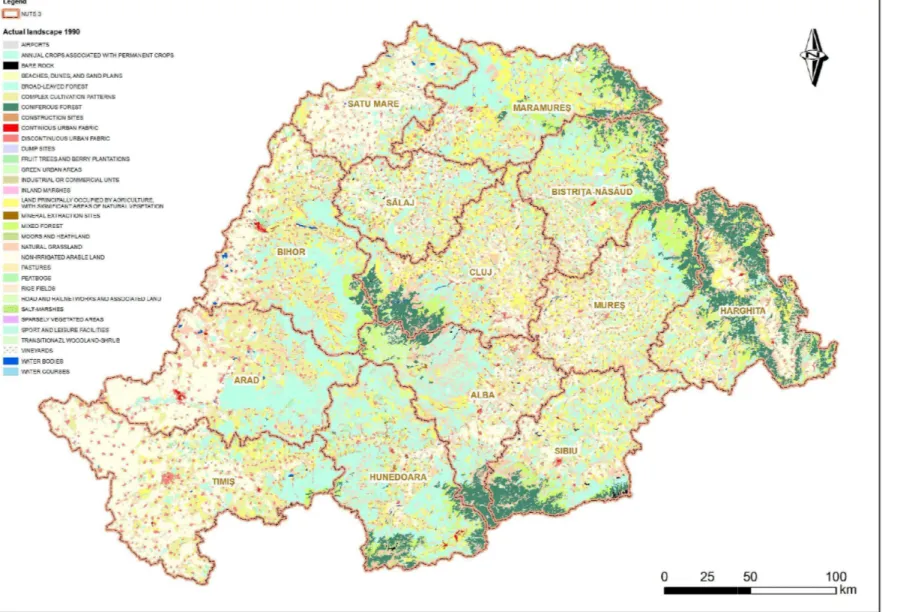
The analysis of the spatial dynamics of the land use structure has been performed comparing the data of the 2000 edition with those of the 1990 edition of CORINE Land Cover. However, it should be mentioned that the 1990 edition included more types of land uses and had less detail, resulting in a higher number of errors compared to the more recent editions. Regarding the classification, for the analysed territory, the 1990 edition presented 33 types of land use, three more than the 2000 edition. However, they can be comprised in other categories, which are part of the 2000 edition and, on the other hand, they cover very small areas, so that a comparison can be performed.
The total area covered by forests in 1990 represented 36.97% of the territory. It comes out that the forests enlarged their area by almost 1% between 1990 and 2000. A more detailed analysis, by types of forest, reveals however that this dynamic is the result of the increase in weight of the broad-leaved forests, from 22.01% (1990) to 24.72% (2000), while the coniferous forests, the mixed forests and the transitional woodland-shrub areas slightly decreased during the same period.
The differences are more significant in the case of arable lands. Their weight decreased from 39.99% (1990) to 35.02% (2000). In this situation too, the analysis by types of lands reveals rather contradictory trends. Thus, the non-irrigated arable lands increased their percentage from 20.91% to 23.50%, while the mainly agricultural lands, with significant areas of natural vegetation, decreased at almost half, from 10.87% to 6.62%, while the complex cultivation patterns, from 8.22% to 4.90%.
In the case of other types of land use, one also remarks contradictory trends. As a result of the constant expansion of built-up areas, especially in the case of cities, towns and their neighbouring villages, the areas covered by continuous or discontinuous urban fabric increased from 4.12% (1990) to 4.81% (2000). On the contrary, the weight of orchards decreased from 1.40% to 1.10%, possibly due exactly to the disappearance of fruit tree plantations near the cities, but also in the deep rural areas. At the same time, the weight of vineyards increased from 0.65% to 0.98%.
This land use dynamics should be taken into consideration with much caution, because of the lack of detail of CORINE Land Cover, especially the 1990 edition.
REFERENCES
ARDELEAN, A. (1999), Flora i vegetaŃia din valea Cri ului Alb [The Flora and Vegetation of the Cri ul Alb Valley], Vasile Goldi University Press, Arad.
BĂRBULESCU, C., MOTCĂ, GH. (1983), Pă unile munŃilor înalŃi [The Grasslands of the High Mountains], Edit. Ceres, Bucure ti.
BOLD, I., CRĂCIUN, A. (1999), Organizarea teritoriului [Territorial Organization], Edit. Mirton, Timi oara.
BO CAIU, N. (1971), Flora i vegetaŃia munŃilor łarcu, Godeanu i Cernei [The Flora and Vegetation of łarcu, Godeanu and Cernei Mountains], Edit. Academiei RSR, Bucure ti. BUTURĂ, V. (1978), Etnografia poporului român [The Ethnography of the Romanian People], Edit.
Dacia, Cluj-Napoca.
CHIRIłĂ, C. – COORD. (1981), Pădurile României. Studiu monografic [The Forests of Romania. Monographic Study], Edit. Academiei RSR, Bucure ti.
COCEAN, P. – COORD. (2009), Mărginimea Sibiului. Planificare i amenajare teritorială
[Mărginimea Sibiului. Territorial Planning and Arrangement], Edit. Presa Universitară
Clujeană, Cluj-Napoca.
COCEAN, P. – COORD. (2010), Planificarea i amenajarea teritoriului zonal. Studiu de caz: valea
Hârtibaciului [The Planning and Arrangement of the Zonal Territory. Case Study: Hârtibaciu
Valley], Edit. Presa Universitară Clujeană, Cluj-Napoca.
CONEA, I. (1984), Plaiuri carpatice [Carpathian Lands], Edit. Sport-Turism, Bucure ti.
CSUCSUJA, I. (1998), Istoria pădurilor din Transilvania 1848-1914 [The History of Forests in Transylvania 1848-1914], Edit. Presa Universitară Clujeană, Cluj-Napoca.
GHI A, E., TUDORAN, P., COLDEA, GH. (1971), ContribuŃiuni la studiul pădurilor din MunŃii
Zarandului [Contributions to the Study of the Forests of the Zarand Mountains], Studia Univ.
Babe -Bolyai, series Biologia, 1/1971, Cluj-Napoca.
GIURESCU, C. C. (2004), Istoria pădurii române ti din cele mai vechi timpuri până azi [The History of the Romanian Forest since Ancient Times until Today], ediŃia a 3-a, Edit. Orion, Bucure ti. GRUMĂZESCU, CORNELIA (1975), Studiul integral al terenurilor în scopul organizării teritoriului
[The Integrative Study of Lands in the Purpose of Territorial Organization], Studii i Cercetări de Geologie, Geofizică, Geografie, seria Geografie, XXII, Bucure ti, pp. 57-66.
IDU, P.D. (1999), Om i natură în CarpaŃii Maramure ului i Bucovinei. ViaŃa pastorală [Man and Nature in the Carpathians of Maramure and Bucovina. The Pastoral Life], Edit. Napoca Star, Cluj-Napoca.
KAKUCS, L. (1998), ContribuŃii la istoria agriculturii din Banat [Contributions to the History of Agriculture in Banat], Edit. Mirton, Timi oara.
RAULARIAN RUSU, TITUS MAN, IOAN FODOREAN and CIPRIAN MOLDOVAN
MORARIU, T., DIHOR, I., IDU, P.D. (1973), Aspecte actuale ale păstoritului de câmpie în Banat
[Present Aspects Concerning Grazing in the Plain of Banat], Anuarul Muzeului Etnografic al Transilvaniei pe anii 1971-1973, Cluj.
MUICĂ, CRISTINA (1991), InfluenŃa modului de utilizare a terenului asupra dinamicii peisajului
[The Influence of Land Use on Landscape Dynamics], Terra, XXIII (XLIII), 2, Bucure ti, pp. 16-19.
PĂCURAR, AL. (1998), Dealurile Crasnei – studiu de geografie economică[Crasna Hills – a Study of Economic Geography], teză de doctorat, Universitatea “Babe -Bolyai”, Cluj-Napoca. POP, I. – COORD. (1978) Flora i vegetaŃia MunŃilor Zarand [The Flora and Vegetation of Zarand
Mountains], ContribuŃii Botanice, Universitatea „Babe -Bolyai” Cluj-Napoca.
POP, GR. P. (1985), Pădurile din MunŃii Apuseni – aspecte geografico-economice [The Forests of Apuseni Mountains – Geographical and Economic Aspects], Studia UBB, Geologia-Geographia, XXX, Cluj-Napoca, pp. 56-66.
POP, GR. P. (2001), Depresiunea Transilvaniei [The Transylvanian Depression], Edit. Presa Universitară Clujeană, Cluj-Napoca.
POP, GR. P. (2005), Dealurile de Vest i Câmpia de Vest [The Western Hills and the Western Plain], Edit. UniversităŃii din Oradea, Oradea.
POP, GR. P. (2006), CarpaŃii i SubcarpaŃii României [The Romanian Carpathians and Subcarpathians], ediŃia a 2-a, Edit. Presa Universitară Clujeană, Cluj-Napoca.
POPESCU, GHE. (1985), Pădurea i omul [The Forest and the Man], Edit. Albatros, Bucure ti. PU CARU-SOROCEANU, E. (1963), Pă unile i fâneŃele din RPR [The Grasslands and Hay Fields
of the People’s Republic of Romania], Edit. Academiei RPR, Bucure ti.
RUSU, R. (2004), ConsideraŃii generale cu privire la modul de utilizare al terenurilor în Banat
[General Considerations Regarding Land Use in Banat], în Geography within the Context of Contemporary Development (Geografia în contextul dezvoltării contemporane), 2001-2003,
Cluj-Napoca, pp. 345-367.
RUSU, R. (2007), Organizarea spaŃiului geografic în Banat [The Geographical Space Organization in Banat], Edit. Mirton, Timi oara.
SURD, V. (2002), Introducere în geografia spaŃiului rural [Introduction to the Geography of Rural Space], Edit. Presa Universitară Clujeană, Cluj-Napoca.
TEORAN, AL. GROZA, AL. (2004), Cronica pădurilor din Ńinuturile Bihorului [The Story of Forests of Bihor], Edit. Abaddaba, Oradea.
UNGUR, A. (2008), Pădurile României – trecut, prezent i viitor [The Forests of Romania – Past, Present and Future], Edit. Devadata, Bucure ti.