EVALUATING LAND USE CHANGES BY LANDSCAPE HISTORICAL EXAMINATIONS
AT THE GREAT PASTURE OF HAJDÚBAGOS (EASTERN HUNGARY)
Zsuzsanna ANTAL*, Lajos JUHÁSZ*, Balázs ANTAL*
*University of Debrecen, Faculty of Agricultural and Food Sciences and Environmental Management, Department of Nature Conservation,
Zoology and Game Management, Debrecen, Hungary
Corresponding author: Zsuzsanna Antal, 138 Böszörményi, 4032 Debrecen, Hungary, tel.: 003652508444/88107, fax: 003652413385, e-mail: [email protected]
Abstract.At an Eastern Hungarian protected grassland, namely at the Lesser Mole Rat (Spalax leucodon Nordmann, 1840). Reservation of Hajdúbagos Nature Conservation Area, grazing animal husbandry formed the façade of the land for hundreds of years. Though, due to the unfavourable changes of the last few decades in this sector of agriculture, the primeval sand steppe meadow (Pulsatillo hungaricae-Festucetum rupicolae (Soó 1938) Borhidi 1996) plant association is endangered by the increasingly accelerating succession. To stop or at least to slow down this process the rehabilitation of the area could be necessary. The target of the restoration ecology actions is to restore the previously existing, more favourable natural status of a particular area. However, the lack of knowledge according to the conditions that refer to the original circumstances often complicates this activity. To define these reference conditions the exploration of the history of a certain landscape is very important as restoration is only successful if the restored ecosystem is similar to the original. We examined the land use changes of the research area during the last 250 years according to historical and present geographical databases using GIS technology and completed this work with the study of archival data. By our results we stated that these examinations are crucial in the proper - agriculture related - management of protected areas.
Keywords: nature conservation, landscape historical examinations, GIS technology, protected grassland.
INTRODUCTION
Despite of the legal protection quick and in a nature conservation view harmful succession changes can be realized at the examination area. The original sand steppe meadow (Pulsatillo hungaricae-Festucetum rupicolae (Soó 1938) Borhidi 1996) plant association is endangered by the partly natural succession [20]. To stop or at least to slow down this process the conservation of the protected species is not enough, the rehabilitation of the area could be necessary [9]. The re-shaping of the dilapidated habitats is possible through restoration ecology actions. The target of the restoration ecology interventions is to restore the previously existing, more favourable natural status of a certain area [5]. However the lack of knowledge according to the conditions that refer to the original circumstances besides the lack of financial sources often complicates this activity [19]. To define these reference conditions the exploration of the history of an individual landscape is very important as restoration is only successful if the restored ecosystem is similar to the original. According to [16] to understand and solve the actual problems the precognition of the premises, the past events and the development trends are necessary.
The landscape historical examinations of a certain territory actually mean the evaluation of the land use changes what could be performed by surveying former maps of the examination area. For this job the I-VII. Military Surveys are the most appropriate sources in Hungary that started in the middle of the 18th century and were created with proper accuracy according to the past technological standards [12]. Considering the similar structure and scaling of the military maps, these sources are the most suitable for landscape historical examinations. Though, other sources like Gauss-Krüger and other topographical maps, cadastral maps, the maps for forestry operations of the State Forest Service, soil, geology, hydrology and vegetation maps, as well as air and space photos could promote our
work. However the reconstruction of the primeval natural status cannot be achieved only by using maps. A correct proposal for the rehabilitation and future use of the examined pasture could be formed only in case we collect as much as we can from the literature sources, historical documentations and archival data of the territory while we need to gather actual information and on site data of the pasture as well [1]. Therefore during our landscape historical examinations we also used geographical and historical descriptions, the experiences of reports and personal interviews, and numerous archival data of the Hajdú-Bihar County Archives.
MATERIALS AND METHODS
Introduction of the examination area
The great pasture of Hajdúbagos that lays in the eastern part of Hajdú-Bihar County southeast from Debrecen, is located geographically in the crossing point of three regions, the South-Nyírség, the Berettyó-Kálló Interfluve and the South-Hajdúság, right next to the territory of the Debreceni Erdőspuszták [4]. As the area is one of the most important Hungarian habitat of the strictly protected Lesser mole rat (Spalax leucodon Nordmann, 1840) [8] it became the Lesser Mole Rat Reservation of Hajdúbagos Nature Conservation Area in 1976. Besides the Lesser mole rat the area is the habitat of other protected animal and plant species as well [2, 3, 10].
grass and the increase of it in height, which is a harmful progression for the natural fauna also. The present day animal stock is only able to graze an insignificant part of the green mass what leads to the accumulation of the organic substance. Therefore mowing against weeding is necessary at some parts of the pasture. However mowing is only a constraint, there is a need to replace it by increasing the number of grazing animals [14]. Though, the animal carrying capacity of the pasture should be taken into consideration to avoid overgrazing as well.
Land historical examinations
For the land historical examinations of the study area we performed cartography surveys. We also investigated the geographical and historical descriptions and management plans, used the experiences of reports and personal interviews, and carried out a significant archival data collection.
To the land use and land historical cartography examinations a database was needed that contains those more dimensional data that have information on the changes of the landscape and of land use both in space and time. To this job we used the maps of the I. (1782-1785), the II. (1819-1869) and the III. (1872-1884) Military surveys, present topographical map sections, important elements of the Digital Base Map of Hungary (administrative units, linear and point map elements) and the present-day newest remote sensed CORINE Land Cover CLC2000 European Land Cover Database. For the cutting and the graphical joining of the map sections we used Adobe Photoshop software.
The georeferation of the raster database created in this manner, was made by identifying reference points by using ESRI ArcGIS software package. After creating the digitalized sections (vector database) we created the geo-database of the land use examinations that contains the necessary data and map sections. With the attribute tables our aim was to quantify land history and land cover, and through this to determine the land use characteristics and the alteration of these features.
We pursued the archival examinations in the Hajdú-Bihar County Archives. We found and processed data from the beginning of the 1750s until the middle of the 1950s. We searched and evaluated data mainly on grazing animal husbandry. Among the archival sources there are censuses from the Sárrét than from the Derecske districts, feudal land tenancy census records, statistical reports and the final accounts of Hajdúbagos settlement as well.
RESULTS
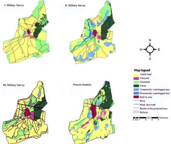
The historical and present maps representing the examined area are telling a lot about land use changes (Figure 1). By the data of the charts below it is noticeable that the close territory of Hajdúbagos is utilized by agriculture for a long while and that significant changes occurred during the past era of the last 250 years.
The review of the land-use changes is possible by the evaluation of the attribute tables that were created by the GIS data base. We indicate the area sizes of the map data from the four different eras by using these attribute tables (Table 1). We made a comparison
among our counted data and the data of the Hungarian Central Statistical Office [11] on the present land use categories and judged our results acceptable.
From a nature conservation view it can be regarded as a favourable amend that the area of the previously
large, nearly continuous arable land decreased in the examination period. The spatial order of the arable land also changed, it became more disjoint what resulted in a more mosaic landscape structure.
Table 1. Changes in the certain land use categories in the examined region between 1782 and 2007.
Size of the land use category / Date of data collection (year)
1782-1785 1819-1869 1872-1884 1995-2007 Land use category
ha % ha % ha % ha %
Arable land 2517.15 66.47% 1698.57 44.85% 2421.38 63.94% 1937.01 51.15% Vineyard 30.82 0.81% 35.78 0.94% 67.03 1.77% 122.95 3.25% Grassland 879.06 23.21% 935.08 24.69% 747.59 19.74% 703.04 18.56% Forest 272.93 7.21% 450.59 11.90% 370.71 9.79% 649.58 17.15% Temporarily waterlogged area 52.57 1.39% 541.96 14.31% 69.50 1.84% 211.47 5.58% Permanently waterlogged area 3.34 0.09% 72.20 1.91% 22.17 0.59% 8.24 0.22% Built in area 31.31 0.83% 53.00 1.40% 88.80 2.34% 154.89 4.09%
Sum 3787.18 100.00% 3787.18 100.00% 3787.18 100.00% 3787.18 100.00%
The area of the vineyards increased against the arable land, the occupancy of this land use category became four times bigger throughout the examined period.
The size of the grasslands also changed a lot during the last two and a half centuries. However the area of the grasslands, that was 23% of the administrative territory of Hajdúbagos in the second half of the 18th century, did not change a lot, only slight alteration happened until the first half of the 19th century, to the end of this century the size of grasslands decreased significantly and by nowadays the land possession of grasslands is only 19%.
Besides the changes in the total area of the grasslands in the territory it is more interesting how the façade of the great pasture of Hajdúbagos changed since 1782 until today. From the map data it is clear the present pasture was covered by arable land almost in its total area 250 years before. Although, to the era of the II. Military survey the land occupancy of the grasslands increased, the size of arable land was still considerable. This phenomenon cannot be the result of the drying of the territory as from the map and table data it is clear that rather much temporary and permanent waterlogs were in the area in the 1800s. These waterlog spots were in connection with the floods of the Tisza and Berettyó rivers. The size of the wet habitats is bigger nowadays as well than it was two and a half centuries before which has on one hand geographical and on the other hand water management reasons. The geographical reason is that the examination area is south from the big Nyírség watershed and lays in the catchment area of the Berettyó. The Derecskei-Kálló canal, or officially the Kati-rill takes in the flowing waters of the territory [15]. The area inclines to the southwest, the landscape characterised by the sand dunes north from the village of Hajdúbagos turns into the lower Bihari plain from the south of the settlement [4]. The historical maps indicate well that the integration of the significant floods of the Tisza and Berettyó rivers and the stagnant waters from these floods [7] and therefore the increase of the Kati-rill caused the leave off of the previous arable lands which
resulted in the spontaneous re-grassing of certain parts of the examination area. The drainage of the waters of the territory brought additional changes. The water drainage activity in the South-Nyírség started already in 1982, since then the area was netted by canals [8] and for the emplacement of the rainwater and inland inundation water reservoirs were built. In the 20th century all together three water reservoirs were built to the south-southwest from Hajdúbagos from which two is replacing previously existing valuable grasslands. Due to these water management activities it became necessary to establish new pastures to the north of the settlement. These changes in the grasslands of the territory resulted in the increase of the former pasture next to the former Debrecen-Oradea transit road [6].
The size of the forests continuously grown, by now there are two times more forests in the region than 250 years before. However it is a fact that the present forests are mainly planted forests, featureless Robinia (Robinia pseudoacacia L.) and Scots pine (Pinus sylvestris L.) plantations of weak quality. From the map data it is also visible that some of the previous natural forests were turned into vineyards. Therefore the judgement of the increase of the forests is controversial in a nature conservation view.
In case we examine the changes in the size of the settlement, it is clear the area of Hajdúbagos grown constantly during the examination period. While between the I. and II. Military surveys the settlement became one and a half times bigger, to the III. Survey this growth is almost a triple. The increase in the size of the village rose further to our days, the area of Hajdúbagos became its twofold during slightly more than 100 years.
also stated that the livestock of the territory decreased significantly during the last century.
DISCUSSION
According to [5] historical information is undoubtedly a valid source for guiding future restoration. The reviewed land historical examinations therefore own practical importance by supporting the planning and carrying out of nature conservation management and restoration activities. As [18] states by citing Jordan et al. ecological restoration is crucial in the preservation of biodiversity, which opinion also strengthens the significance of our results.
The geo-database compiled to the studied area became suitable for running land calculation algorithms according to land use categories. By these results to create land cover timelines in case of the certain land use categories became possible. By the map and table data of the GIS database it is apparent that in the land use of the examined area significant changes happened throughout the past two and a half centuries. According to the GIS examinations it also turns out that the area of the examined pasture once was arable land thus the protected area cannot be regarded as primeval grassland, what is necessary to be considered in its management. The changes in the façade of the area that can be followed on the maps indicate that the present pasture was not always waterlogged, thus certain opinions according to which the water supplementation of the area and the alteration of its water management characteristics are very important are not necessarily consistent.
Besides the valuable historical information gained through the introduced survey the opinion of [5] should be emphasised, namely that the environmental conditions of the future will likely be different from the past, therefore a restored ecosystem rigidly aimed at historical fidelity may not be sustainable in the future. Present environmental circumstances should always be taken into account for the proper management of a protected area. In accordance with this statement by the results of the land historical examinations introduced in this paper, the preservation of the present land use form namely the grass cultivation branch is unquestionably suggestible. For the management of this extensive pasture grazing is the most suitable method, however the land characteristics should be taken into account precisely and the grazing activity should be planned according to the special features of this grassland. For the sake of the careful management the concrete animal carrying capacity of the pasture should be considered. Controlling the number of livestock used is very important, especially in dry years, to avoid overgrazing and trampling [17]. During the planning of the grazing activity the genotype of the grazing animals and the features of the grassland should be harmonized. Intensive animal breeds are not suitable to graze an extensive pasture. Only extensive breeds should be utilized that are traditional in the region. The animal species grazed on the examined pasture also should be considered as the feeding habits and the trampling of
sheep and cattle are rather different, therefore these animals have different load on the grassland.
A complete botanical survey is accessible to the examination area [3]. By using this botanical database as a basis, the changes in the botanical structure of the pasture should be followed to be able to react to the negative changes immediately. The vegetation and seed bank sampling method used by [13] is an applicable way of evaluate the spread of competitive grasses and also aggressive woody plants like Robinia (Robinia pseudoacacia L.) and Common hawthorn (Crataegus monogyna Jacq.). The analysis of aerial photographs with GIS methods is mainly suitable to react to the spread of unwanted woody plant species in time. The control of these plants could be carried out either by mechanical or by chemical methods, however the preference of mechanical methods is desired on protected areas.
Acknowledgements: The authors would like to express their thanks to J. Antal for his help in the field and GIS examinations.
REFERENCES
[1] Antal, Zs., (2006a): Tájtörténeti vizsgálatok a hajdúbagosi
Nagy-Nomás legelő területén. V. Alföldi Tudományos
Tájgazdálkodási Napok, Mezőtúr, 2006 Oct. 26-27, CD
issue.
[2] Antal, Zs., (2006b): The alteration of proportion of different lizard species compared to each other at the
great pasture of Hajdúbagos. Analele Universităţii din
Oradea, Fascicula Biologie, 13: 35-38.
[3] Antal, Zs., Tanyi, P. (2007): Botanical survey at the great pasture of Hajdúbagos. Analele Universităţii din Oradea, Fascicula Biologie, 14: 5-16.
[4] Baranyi, B., (2001): Hajdúbagos, ahol az egyetlen hazai Földikutya-rezervátum található. pp. 110-119. In Baranyi, B. (ed.): Magyarország kisrégiói 8/2. Hajdú-Bihar megye Debrecen és térsége. CEBA Kiadó, Budapest.
[5] Choi, Y.D., Temperton, V.M., Allen, E.B., Grootjans, A.P., Halassy, M., Hobbs, R.J., Naeth, M.A., Török, K., (2008): Ecological restoration for future sustainability in a changing environment. Ecoscience, 15: 53-64.
[6] Dankó, I., (1975): A mezővárosi parasztpolgárság
életmódbeli hagyományai Hajdúbagoson. pp. 90-116. In Dankó, I., (ed.): Bagosi Krónika, Hajdúbagos.
[7] Goda, P., (1984): Vízi munkák a Körös-Sárrét vidékén. In
Goda, P., Köteles, L. (eds.): Körös-Sárréti Útikalauz.
http://www.kvte.hu/ksar/ksar00.htm accessed in: April 2010.
[8] Gyarmathy, I., (1993): A Hajdúsági Tájvédelmi Körzet. pp. 9-17. In: Lovas, M. (ed.): A Hajdúsági Tájvédelmi
Körzet. Déri Múzeum Baráti Köre – Hortobágyi Nemzeti
Park Igazgatóság, Debrecen.
[9] Halassy, M., (2001): A restaurációs ökológia alapjai. pp. 233-238. In: Szabó, M. (ed.): A természetes életközösségek megóvásának és monitorozásának aktuális problémái, ökológiai alapja, a természetvédelem
feladatai. ELTE-TTK - SZIE-KGI - KöM-TvH.
Budapest-Gödöllő-Madrid-Fort Collins.
[10] Juhász, L., Antal, Zs., (2007): A Hajdúbagosi Földikutya Rezervátum Természetvédelmi Terület herpetofaunisztikai felmérése. pp. 23-30. In Magyari, M.
(ed.): A Debreceni Déri Múzeum Évkönyve 2006.
Hajdú-Bihar Megyei Múzeumok Igazgatósága. Debrecen. [11] KSH (2000): KSH ÁMÖ 2000. Földhasználat
[12] Lukács, A., Szigetvári, C., Botos, I.C., Rév, S., (2004): Tájtörténeti vizsgálatok és a tájrehabilitáció lehetőségei a Nyírségben. Ifjú Botanikusok Baráti Köre – E-misszió Természet- és Környezetvédelmi Egyesület. Nyíregyháza.
[13] Matus, G., Tótmérész, B., Papp, M. (2003): Restoration prospects of abandoned species-rich sandy grassland in Hungary. Applied Vegetation Science 6: 169-178. [14] Mazsu, I., (2001): Gazdasági, társadalmi és kulturális
jellemzők. pp. 44-46. In Mazsu, I. (ed.).: Hajdúbagosi
Földikutya Rezervátum kezelési terve. Hortobágyi
Nemzeti Park Igazgatóság, Debrecen.
[15] Molnár, A., (2001): Fizikai jellemzők. pp. 12-14. In
Mazsu, I. (ed.). Hajdúbagosi Földikutya Rezervátum kezelési terve. Hortobágyi Nemzeti Park Igazgatóság. Debrecen.
[16] Pallás, I., (1975): Beköszöntő. pp. 6. In: Dankó, I. (ed.): Bagosi Krónika. Hajdúbagos.
[17] Šefferová Stanová, V., Vajda, Z., Janák, M. 2008. Management of Natura 2000 habitats. 6260 Pannonic sand steppes. European Commission.
[18] Török, K., Halassy, M., Szabó, R., (2003): Restoration strategy for endemic grasslands in a low productive
region of Hungary Proceedings of the VIIth International Rangeland Congress, Durban, South Africa, 26 July - 1 August 2003, pp. 1132-1138.
[19] Török, P., Tótmérész, B., (2005): A debreceni Nagyerdő
növényzetének természetessége aktuális és történeti adatok alapján. P. 218. In: Lengyel, S., Sólymos, P., Klein, Á. (eds.): A III. Magyar Természetvédelmi Biológiai Konferencia program és absztrakt kötete. Magyar Biológiai Társaság, Budapest.
[20] Varga, Z. (2001): Állattenyésztés, legeltetés. In: Mazsu, I. (ed.). 2002. Hajdúbagosi Földikutya Rezervátum kezelési terve: 46. Hortobágyi Nemzeti Park Igazgatóság. Debrecen.
Submitted: 12 April 2010 Accepted: 2 May 2010
Analele Universităţii din Oradea – Fascicula Biologie http://www.bioresearch.ro/revistaen.html