Probing the relationship between
surface waters and aquifers by
18
O
measurements on the top
of the Araripe Plateau/NE Brazil
Luiz Alberto Ribeiro Mendonc¸aÆHorst Frischkorn ÆMaria Marlu´cia Freitas Santiago Josue´ Mendes Filho
Abstract The Araripe Plateau in northeastern Brazil has an area of about 8,000 km2, confined by 3905¢E and 4055¢E, and 710¢S and 750¢S. Due to high permeability of soils, a surface drainage system is practically inexistent. Water is stored in excavations with clayey soil, the ‘‘barreiros’’. Monthly samples were taken for18O measurements, from September 1999 to August 2000, from four barreiros, three dug wells and five drilled wells. Results show that (1) groundwaters in the eastern part of the plateau are derived from present-day rainfall (d18O)3.2&),
whereas groundwaters in the western portion are isotopically different (d18O)5.0&); (2) barreiros
are strongly marked seasonally by elevatedd18O
during the dry period due to elevated evaporation; (3) a dug well at a distance of30 m from a barreiro exhibitsd18O similar to that of the reservoir,
indicating a strong interaction between groundwater and surface water; and (4) a tubular well of 242-m depth, located in a fault, exhibits strong seasonal changes ind18O and electrical conductivity,
revealing downward leakage between aquifers.
Keywords Isotope hydrologyÆ Oxygen-18Æ Araripe PlateauÆHydraulic connectionsÆ Brazil
Introduction
The study of the interaction between surface waters and aquifers through oxygen-18 measurements was applied in the Araripe Plateau in the semiarid zone of the Brazilian Northeast. In spite of rainfall amounting to 1,000 mm, due to the high hydraulic conductivity of sandy soils there are practically no surface water resources on top of the Ara-ripe Plateau, except for the water stored in excavations covered with clayey soil (‘‘barreiros’’) trampled for impermeabilization by livestock during drought periods. Part of the rainfall water that infiltrates on the plateau is responsible for recharging the superior aquifer system. Main groundwater discharge from this system is through some 300 springs along the northern scarp of the plateau that produce about 40.5·106m3per year (DNPM 1996). Groundwater exploitation through drilled wells in the superior aquifer system is difficult due to the average water-table depth of 120 m. However, the ‘‘Jardim’’ Fault, in the very east of the plateau, with an extension of about 34 km and 400 m in width in a topographic depression, defines a strip-like area where the water-table depth is only 3 m (Marques and others 1984), thus allowing the construction of dug wells.
At present, in the Araripe Plateau, there are five pioneer wells, recently drilled for exploiting the medium aquifer system with a static water level of 360 m.
The aquifers studied are subject to a regional climate that is characterized by two distinct seasons: rainfall is limited to the 5 months from February to June, and the rest of the year is practically dry.
Oxygen-18 has been used in recent years, e.g., by Mathe-ney and Gerla (1996) and Yehdegho and others (1997), as a natural tracer to investigate the hydraulic relationship between surface waters and groundwater. McCarthy and others (1997) used deuterium and 18O to study the dynamic relationship between groundwater and the Columbia River. The authors made simple mixing calculations for the determination of the contribution of the river to the water produced by five wells.
In the present study, investigating the hydraulic relation-ship between surface waters and groundwater, measure-ments of18O and electrical conductivity were used for the characterization of infiltrating, modern meteoric water, evaporated modern water from ‘‘barreiros’’, and aquifer Received: 13 June 2003 / Accepted: 11 November 2003
Published online: 27 February 2004
ªSpringer-Verlag 2004
L. A. R. Mendonc¸aÆM. M. F. SantiagoÆJ. Mendes Filho
Departamento de Fı´sica da UFC, Caixa Postal 6030, CEP 60455-970 Fortaleza, CE, Brazil
H. Frischkorn (&)
Departamento de Engenharia Hidra´ulica e Ambiental da UFC, Caixa Postal 6006, CEP 60455-970 Fortaleza, CE, Brazil E-mail: [email protected]
water. These parameters and their seasonal variations permit the detection of mixtures and mixing ratios for these components.
Area of study
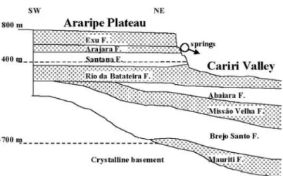
The area of study consists of a plateau, the ‘‘Chapada do Araripe’’, and a valley, the ‘‘Vale do Cariri’’, north of it (Fig. 1). The Araripe Plateau, in the interior of the Bra-zilian Northeast, covers an area of about 8,000 km2, has an average altitude of 800 m, and is partitioned between the three states of Ceara´, Pernambuco and Piaui. This area is delimited by the following geographical coordinates: 3905¢E and 4055¢E, and 710¢S and 750¢S. The Araripe Plateau coincides with the outcropping area of the Exu Formation. A schematic profile is depicted in Fig. 2. According to Ponte and Appi (1990), the sedimentary se-quence is composed, from the top to the crystalline base, by the formations Exu, Arajara, Santana, Rio da Batateira, Abaiara, Missa˜o Velha, Brejo Santo and Mauriti. The Exu and Arajara formations compose the superior aquifer system, the Rio da Batateira, Abaiara and Missa˜o Velha formations the medium aquifer system, and the Mauriti F. the inferior aquifer system. The first system is separated from the second by the Santana aquitard, and the inferior aquifer system is separated from the medium aquifer system by the Brejo Santo aquitard.
In the northern margin of the superior aquifer system, there is an average hydraulic gradient of)7&that induces
a groundwater flow to the scarp in the Cariri Valley, where a large number of springs emerge from the geological contacts Exu/Arajara and Arajara/Santana. In the central part, groundwater flow is from east to west (SUDENE 1967; Mendonc¸a and others 2001a), driven by a gradient of about)2&. On this pathway, flow is being intercepted by
manifold tectonic features.
Methodology
The18O/16O ratio in rainfall water of a specific region depends on several factors, distance to the coast, altitude, atmospheric temperature and the amount of rainfall being the most important. Furthermore, seasonal variations and latitude dependence also are observed to affect the18O/16O ratio. Surface water is enriched in18O due to evaporation and, therefore, in the semiarid Brazilian Northeast exhibits a strong seasonal variation in its isotopic composition. In deep groundwaters,18O/16O is conserved and characterizes the recharge water.
Isotopic18O measurements are expressed in units ofd(&),
defined as the relative permil deviation of the isotope ratio
18O/16O in a sample from that of a standard:
d18Oðo=ooÞ ¼
18O=16O
ð Þsampleð18O=16OÞ
standard
18O=16O
ð Þstandard 10
3
Samples were collected monthly, from September 1999 to August 2000, in four barreiros, three dug wells, and five tubular wells indicated in Fig. 1.
d18O (&) measurements were performed at the Centro de
Energia Nuclear na Agricultura (CENA) in Piracicaba/Sa˜o Paulo, with a precision better than ±0.15&, in relation to the standard VSMOW (Vienna Standard Mean Ocean Water).
Results
Barreiros and dug wells
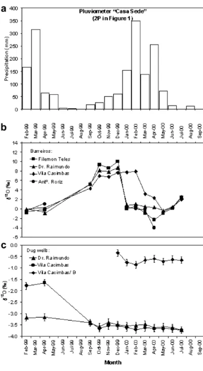
Results for18O and electrical conductivity (EC) on samples from four barreiros and three dug wells in the east of the Araripe Plateau (see Fig. 1) are listed in Table 1, and plotted in Fig. 3b, c together with precipitation (Fig. 3a).
Fig. 1
Tubular wells
Thed18O values for water samples taken from tubular
wells in the eastern and western parts of the Araripe Plateau are listed in Table 2 and plotted in Fig. 4. Figure 5 shows18O and electrical conductivity (EC) from February 1999 to September 2000 for the barreiro in Vila Cacimbas and for the dug well named Vila Cacimbas/B.
Discussions
Barreiros and dug wells
By analyzing Fig. 3 it is observed that all barreiros have a similar temporal behavior. In drought periods, from Sep-tember 1999 to December 1999 and from June 2000 to July 2000, the concentration of18O increases due to evapora-tion. In rainy periods, from February 1999 to April 1999
and from January 2000 to May 2000,d18O decreases,
thereby indicating the renewal of water through rainfall waters, which have lowerd18O than the water in the
res-ervoir. Small differences between these barreiros are due to their different usage and construction procedure. The rainfall contribution to the barreiros is made through direct precipitation in the storage area, and mainly by temporary surface runoff guided into small drains known as ‘‘water pathways’’. The existence of such small creaks efficiently promotes the conduction of rainfall water that otherwise would infiltrate into the sandy soils of the plateau.
The barreiro Antonio Roriz does not dispose of an efficient clay revestment for keeping water stored during the dry season, thus drying up rapidly after its onset.
Contrasting with the barreiros Dr. Raimundo and Filemon Teles, the barreiro Vila Cacimbas presents smaller sea-sonal variations ind18O. The fact that in the dry period d18O is less positive reveals that this barreiro is connected
to the water of the aquifer. In the rainy season,d18O is less
negative, indicating that the renewal through rainfall water is of less importance than in the barreiros Dr. Raimundo and Filemon Teles.
At the onset of the rainy period,d18O for the barreiros Dr.
Raimundo and Filemon Teles reacts without delay, whereas barreiro Vila Cacimbas exhibits a 2-month delay (Fig. 3b). These differences in the behavior are certainly due the coupling of the latter water body to the much greater reservoir that the superior aquifer system represents. However, there are other reasons as well: the barreiros Dr. Raimundo and Filemon Teles constitute the exclusive source of water for the respective locations and are being used for small-scale irrigation and cattle breading; their runoff collecting ‘‘water pathways’’ are therefore maintained in good condition by permanent care. In contrast, the barreiro Vila Cacimbas is in a topographic depression where the water table is near
Fig. 2
Schematic profile of the Araripe sedimentary basin.Shaded zones are aquifers
Table 1
Measurements ofd18O (&) and electrical conductivity (EC) for samples taken from barreiros and dug wells on the top of the Araripe Plateau
(barreiros:1BFilemo´n Teles,2BDr. Raimundo,3BVila Cacimbas,4BAntoˆnio Roriz; dug wells:1PADr. Raimundo,2PACacimbas,3PAVila Cacimbas/B)
Year Month d18O (&) EC (lS/cm)
Barreiro Dug well Barreiro Dug well
1B 2B 3B 4B 1PA 2PA 3PA 3B 3PA
1999 Feb )0.79 )0.12 )0.25 )0.51 )3.17 )1.79 – 83 –
Apr )0.25 )0.89 0.08 1.03 )3.16 )1.65 – 68 –
Sep 5.12 5.35 4.3 Dry )3.42 )3.4 – 93 –
Oct 9.35 8.14 6.94 Dry )3.58 )3.66 – 122 –
Nov 8.66 7.83 6.78 Dry )3.39 )3.54 – 124 –
Dec 10.01 8.7 7.63 Dry )3.49 )3.54 )0.34 139 152
2000 Jan 0.04 0.79 7.71 0.48 )3.55 )3.62 )0.76 190 140
Feb 0.57 0.97 7.94 0.03 )3.53 )3.71 )0.86 210 156
Mar )0.93 0.46 3.18 )0.25 )3.47 )3.63 )0.66 127 164
Apr )2.3 0.34 2.29 )4 )3.63 )3.66 )0.6 126 164
May )0.9 )0.33 )0.54 Dry )3.59 )3.66 )0.72 77 183
Jun 0.11 0.41 0.29 Dry )3.62 )3.68 )0.63 81 189
surface and the population disposes of dug and drilled wells. Under these conditions, maintenance of the surface water reservoir is neglected and ‘‘water pathways’’ are taken over by vegetation.
d18O values for water collected from the dug wells Dr.
Raimundo and Vila Cacimbas did not present significant variations from September 1999 to July 2000, scattering closely around an average of)3.58&(Fig. 3c). This is
consistent with the averaged18O value of)3.76&for wells
exploiting waters from the Arajara aquifer in the eastern sector of the plateau (Mendonc¸a and others 2001b). The dug well Vila Cacimbas was not being pumped from February 1999 to April 1999. Thus, the water presented an averaged18O value of)1.72& in this period, typical of
evaporated water.
The dug well Vila Cacimbas/B, at a distance of 30 m from the barreiro Vila Cacimbas, produces water of
d18O=)0.67&. This value is much higher than the
average value for waters exploited by other wells in the neighborhood. However, it is similar to d18O measured
in barreiros during the rainy period (Fig. 3), i.e., when the water level is elevated. This result indicates an injection of surface water into the groundwater. This assertion is further confirmed by comparing the tempo-ral behavior of the electrical conductivity and d18O
val-ues for the barreiro Vila Cacimbas with those valval-ues for the dug well Vila Cacimbas/B. The barreiro exhibits strong changes in salt concentration and isotopic enrichment through evaporation. The highest d18O
con-centration occurred in February 2000, which also corre-sponds to the highest salt concentration (see Fig. 5). The minimum values for EC and d18O occur at the end of the
rainy season in May. Similar variations in EC and d18O
occur in the dug well, but with a delay of about 7 months corresponding to a groundwater flow velocity of about 4.5 m per month.
Tubular wells
Figure 4 shows that the waters exploited in the eastern sector of the plateau are isotopically distinct from those exploited in the western sector.
d18O values for the tubular well Betaˆnia, closest to the scarp,
vary only slightly around an average of)3.15&(see
Table 2). This is consistent with the average value of
)3.24&for springs at the interface Exu/Arajara (Mendonc¸a
and others 2001b). Also, the EC of 30lS/cm for the well is very close to that for waters from these springs.
The tubular wells Vila Cacimbas and Serrolaˆndia I exploit water from the Arajara aquifer, presenting an EC of 85lS/cm, exactly the same as observed for waters from springs at the Arajara/Santana contact of the scarp of the plateau (Santiago and others 1997). In spite of this chemical similarity, the waters from the two wells present
d18O values completely different from each other, namely,
)3.56 and)4.70&. The former value agrees with that for
the springs, )3.59&(Mendonc¸a and others 2001b), the
latter not.
The tubular well 4-BO-01-PE exploits the Rio da Batateira aquifer confined on its top by the Santana aquiclude. The average electrical conductivity is 1,098lS/cm (Mendonc¸a and others 2001b), andd18O remains practically constant,
with an average of)4.70&(Fig. 4). The tubular well
Serrolaˆndia I also presentsd18O values in the same range.
It is noteworthy that these values are much lower than the average for modern rainfall in the region, which is between
)3.20 and)3.70&. Frischkorn and others (1984) have
shown that significantly lowerd18O in deep sedimentary
aquifers of the northeast of Brazil is due to the presence of paleowaters older than about 10,000 years. These waters accumulated before a +5C climate change at the Pleistocene/Holocene transition.
The tubular well Serrolaˆndia II (242 m in depth) produces water from a sandstone lens (9 m in thickness) inside the Santana Formation. In the dry period this well exhibits
Fig. 3a–c
d18O similar to that of the wells Serrolaˆndia I and
4-BO-01-PE. However, systematic changes are observed in the rainy season. Considering an error of 0.15&for these isotope measurements, the observed changes could seem to be negligible. However, systematic, simultaneous changes are monitored also in the water quality, as illus-trated in Fig. 6. EC varies from over 1,000lS/cm in the dry season to about 250lS/cm at the end of the rainy season.
Lowestd18O values of )4.69 and )4.84&, observed in
November 1999 and August 2000, respectively, are marked by the presence of paleowaters in the superior aquifer system in the western sector of the plateau. The maximum
d18O value of )4.24&was observed in March 2000,
evi-dencing a contribution from waters isotopically very dif-ferent, originating from modern waters in the superior aquifer system, indicating downward leakage. By plotting
d18O vs. EC (Fig. 7), one observes a linear relation
(R=0.941) that can be satisfactorily represented as a mix-ture of one component with high EC and lowd18O with
another one with low EC and highd18O.
For a quantitative analysis of the mixture, the authors adopted end members of EC andd18O of 1,040lS/cm and
)5.00&, respectively (for the paleocomponent), and of
85lS/cm and)3.70&. These latter values characterize the modern recharge waters in the superior aquifer system, as measured for the wells 1PA and 2PA (Table 1). The intermediate values are averages weighted with the concentration of each component.
The temporal variation of EC in the well Serrolaˆndia II was used for the determination of the percent contribution of the modern component, by using the values predicted by the mixing line shown in Fig. 7. The calculated results are listed in Table 3.
Fig. 4
d18O as a function of time for tubular wells located in the eastern and western sections of the Araripe Plateau Table 2
Measurements ofd18O (&) for tubular wells on the top of the Araripe Plateau
Year Month d18O (&)
Tubular well
Western sector Eastern sector
Vila Cacimbas Vila Betaˆnia Serrolaˆndia I Serrolaˆndia II 4-BO-01-PE
1999 Sep )3.44 – – – –
Oct )3.54 )3.12 )4.72 – )4.55
Nov )3.46 )2.99 )4.54 )4.69 )4.51
Dec )3.49 )3.05 )4.64 – )4.61
2000 Jan )3.39 )3.14 )4.45 )4.46 )4.65
Feb )3.79 )3.37 )4.93 )4.32 )4.89
Mar )3.58 – )4.65 )4.24 )4.74
Apr )3.62 )3.11 )4.66 )4.28 )4.67
May )3.57 )3.19 )4.72 )4.46 )4.59
Jun )3.65 )3.16 )4.68 )4.52 )4.6
Jul )3.68 )3.18 – – –
Aug – – )4.74 )4.84 )4.85
A comparison of the percent contribution from the mod-ern component with rainfall (Fig. 8) illustrates the fast reaction of the well to recharge to the upper aquifer system with a delay of about one month only. This may occur either due to leaks in the well sealing or to deep, open faults in the sedimentary package.
Hydraulic connections through geologic faults in the Santana aquiclude were recently discussed by Santiago and others (1997), using a phenomenological model for groundwater circulation in the Araripe sedimentary basin, and by Mendonc¸a and others (2001c), reporting on
MODFLOW simulation of the depression cone for well 4-BO-01-PE on the top of the Araripe Plateau.
Conclusions
Oxygen-18 and EC measurements permit the character-ization of surface waters and groundwater in the Araripe Plateau, and an understanding of the relationship between them.
Fig. 6
Electrical conductivity (EC,left axis) andd18O values (right axis) for
the water samples taken from the tubular well Serrolaˆndia II Fig. 7
Linear plot of EC vs.d18O for samples from the well Serrolaˆndia II Fig. 5a, b
Measurements of18O in samples from four ‘‘barreiros’’, three dug wells and five drilled wells reveal that ground-waters from the eastern part of the Araripe Plateau are derived from present-day rainfall, characterized byd18O
between)3.2 and)3.7&, while groundwaters from the
western portion are isotopically different, withd18O
approximately)5.0&, revealing the presence of
paleowa-ters. Due to elevated evaporation, the surface reservoirs ‘‘barreiros’’ are strongly marked seasonally by elevated18O and EC during the dry period. The dug well Vila Cacimbas/
B, at a distance of approximately 30 m from a ‘‘barreiro’’, exhibitsd18O and EC similar to that of the reservoir in the
rainy season, indicating strong interaction between groundwater and surface water. Thus, special care should be taken with respect to water quality of these surface reservoirs, as they constitute a risk to groundwater con-tamination. Despite a depth of 242 m, the tubular well Serrolaˆndia II, located in a fault, exhibits strong seasonal changes ind18O and EC, revealing downward leakage
between aquifers. As the waters from the two aquifers
Table 3
Percent contribution, X, from the modern component to the water produced by well Serrolaˆndia II, together with measured and calculated EC andd18O
Month Measured X (%) Calculated
EC d18O EC d18O
(lS/cm) (&) (lS/cm) (&)
Nov 1999 1,039 )4.69 12 925 )4.84
Jan 2000 526 )4.46 41 650 )4.47
Feb 2000 420 )4.32 55 510 )4.28
Mar 2000 262 )4.24 68 390 )4.12
Apr 2000 510 )4.28 66 410 )4.14
May 2000 522 )4.46 51 550 )4.33
Jun 2000 714 )4.52 34 714 )4.56
Aug 2000 1,026 )4.84 1 1,026 )4.98
Fig. 8a, b
involved are different in terms of isotope composition and salinity, the water produced by this well may be identified as a mixture of two components: an older one, of high EC (1,040 lS/cm) and lowd18O ()5.00&), and a younger component, of low EC (85 lS/cm) and highd18O ()3.70&). Mixing calculations (Table 3) reveal that the
Serrolaˆndia II well receives a contribution of up to 68% from the young component in the rainy period (March 2000), whereas this contribution amounts to just 1% in the dry period (August 2000).
Acknowledgements The authors express their gratitude to Jose´ Yarley de Brito, Walber Cordeiro and Antoˆnio Ribeiro Zaranza from COGERH for logistic support; to professors Plı´nio Barbosa de Camargo and Marcelo Zacarias Moreira from CENA/USP– Piracicaba for isotope measurements; to Rodolfo Jose´ Sabia´, Danielle Ina´cio Magalha˜es, Raimunda Moreira Franca, Francisco Ramis da Silva, and Vanda Alves Feitosa from Nu´cleo de Estudos dos Recursos Hı´dricos da Chapada do Araripe/URCA for helping in sampling; to Antoˆnio Gomes de Sousa Filho for translating this paper; and to FUNCAP for financial support.
References
DNPM (1996) Projeto avaliac¸a˜o hidrogeolo´gica da bacia sedi-mentar do Araripe (Hydrologic evaluation of the sedisedi-mentary Araripe Basin). Departamento Nacional de Pesquisas Minerais, Recife
Frischkorn H, Torquato JRF, Santiago MF (1984) Medidas isoto´picas em aqu¨ı´feros profundos na regia˜o centro-oeste do Piauı´ (Isotope measurements on the deep aquifers of Piauı´. In: Proc 3rd Congr Brasileiro de A´ guas Subterraˆneas, Fortaleza. Associac¸a˜o Brasileira de A´ guas Subterraˆneas, Sa˜o Paulo, pp 42–51
Marques AAF, Macedo IP, Marinho JML, Oliveira RR (1984) Eletrorresistividade aplicada a` prospecc¸a˜o de a´gua subterraˆnea na Chapada do Araripe-CE (Electric resistivity applied to groundwater prospections on the Araripe Plateau). In: Proc 3rd Congr Brasileiro de A´ guas Subterraˆneas, Fortaleza. Associac¸a˜o Brasileira de A´ guas Subterraˆneas, Sa˜o Paulo, pp 269–283
Matheney RK, Gerla PJ (1996) Environmental isotopic evidence for the origins of ground and surface water in a prairie dis-charge wetland. Wetlands 16:109–120
McCarthy KA, McFarland WD, Wilkinson JM, White LD (1997) The dynamic relationship between ground water and the Columbia river: using deuterium and oxygen-18 as tracers. J Hydrol 135:1–4
Mendonc¸a LAR, Frischkorn H, Santiago MF, Mendes Filho J (2001a) Modelagem matema´tica dos aqu¨ı´feros da Chapada do Araripe (Mathematical modeling of the Araripe Plateau aqui-fers). In: Proc 14th Simp Brasileiro de Recursos Hı´dricos, 5th Simp Hidra´ulica e Recursos Hı´dricos dos Paı´ses de Lı´ngua Portuguesa, Aracaju´. Associac¸a˜o Brasileira de Recursos Hı´dri-cos, Sa˜o Paulo
Mendonc¸a LAR, Frischkorn H, Santiago MF, Mendes Filho J (2001b) Modelagem isoto´pica de aqu¨ı´feros da Chapada do Araripe (Isotope modeling of the Araripe Plateau aquifers). In: Proc 14th Simp Brasileiro de Recursos Hı´dricos, 5th Simp Hidra´ulica e Recursos Hı´dricos dos Paı´ses de Lı´ngua Portu-guesa, Aracaju´. Associac¸a˜o Brasileira de Recursos Hı´dricos, Sa˜o Paulo
Mendonc¸a LAR, Frischkorn H, Santiago MF, Mendes Filho J (2001c) Simulac¸a˜o do cone de rebaixamento do poc¸o 4-BO-01-PE na Chapada do Araripe utilizando o MODFLOW (Drawdown simulation for well 4-BO-01-PE on the Araripe Plateau using MODFLOW). In: Proc 14th Simp Brasileiro de Recursos Hı´dri-cos, 5th Simp Hidra´ulica e Recursos Hı´dricos dos Paı´ses de Lı´ngua Portuguesa, Aracaju´. Associac¸a˜o Brasileira de Recursos Hı´dricos, Sa˜o Paulo
Ponte FC, Appi CJ (1990) Proposta de revisa˜o da coluna lit-oestratigra´fica da Bacia do Araripe (Proposal for a revision of the litho-stratigraphic column of the Araripe Basin). In: Proc 36th Congr Brasileiro de Geologia, Natal. Sociedade Brasileira de Geologia, Sa˜o Paulo, pp 211–226
Santiago MF, Silva CMSV, Mendes Filho J, Frischkorn H (1997) Characterization of groundwater in the Cariri (Ceara´, Brazil) by environmental isotopes and electric conductivity. Radiocarbon 39:49–59
SUDENE (1967) Estudo geral de base do Vale do Jaguaribe— hidrogeologia (Jaguaribe Valley: basic studies—hydrogeology). Superintendeˆncia de Desenvolvimento do Nordeste, Recife Yehdegho B, Rozanski K, Zojer H, Stichler W (1997) Interaction