It is the first time pockmark-like structures have been detected in the south-eastern part of the Gulf of Finland with the help of a side-scan sonar and a profile recorder. The analysis of the distribution of microcomponents in the bottom sediment indicates that the pockmark area is located in the geo-chemical barrier border zone where the reducing medium of the incoming min-eralized solution meets the highly oxidiz-ing sea water medium. The hydrody-namic and geochemical processes in the pockmark zone create focal areas of anomalous microenvironment and affect the composition and development of benthos.
Key words: pockmark, Baltic Sea, geochemical barrier, rare earth elements.
Introduction
This article presents the results of geological-geochemical studies carried out in the pockmark field in the eastern part of the Gulf of Finland.
As in other marine basins, the Holocene layers of marine sediments of the Baltic Sea are rich in gas-containing soils. The source of the gas (pre-dominantly methane) is the gas generation processes accompanying the de-composition of organic matter contained in the soils. The specific mor-phostructures — pockmarks — of different diameters apparently form as a result of the soil particles forced out by the migrating gas. In the early 1970s, the anomalies in distribution of hydrocarbon gases in the waters of the Baltic Sea were first detected [1]. The geophysical and geological studies carried out during a series of expeditions in the Baltic Sea showed that the increased content of methane in bottom water layers is determined by the discharge of gas-containing fluids, whose localisation is a result of the specific geomor-phologic structure of the seabed (depressions, craters, etc). Methane craters with peculiar gas-enriched sediments and increase content of methane in the near-bottom water were detected in the Baltic Sea within the Gdansk, Ark-ona, and Gotland basins [2]. Pockmark agglomerations can indicate the vi-cinity of hydrocarbon presence, geochemical, barriers, buried terrain irregu-larities, reduced zones and buried fractures both in sediment layers and the basement.
Pockmarks had never been detected in the eastern part of the Gulf of Finland before. They were first discovered during expedition operations in the south-eastern part of the Gulf of Finland (December 2009) by the au-thors of the article with the help of side-scan sonar and profile recorder da-ta (fig. 1, 2). The form of craters is rounded, oval in plan, sizes in plan
Varvara Ivanova
Dubrava Kirievskaya
Alexander Bolotov
THE GEOCHEMICAL CHARACTERISTICS
range from the first meters to the first tens of meters, the relative depth from the first tens of centimetres to the first meters.
Fig. 1. A general scheme of the operation site
Pockmarks have been discovered in an area with the exodynamic situa-tion of prevalent sediment accumulasitua-tion. The area of pockmark prevalence lies within the intersection of the sublatitudinal and submeridional zones of fractures in the crystalline basement. The signs of free gas presence in the near-surface sediment were not found on the profile records of the areas studied.
On the basis of geophysical data, tow pockmark-like structures — H1 and H2 — were chosen in different parts of the studied area for further research (fig. 1, 2).
Material and methods
Two monitoring stations collected samples of bottom and near-surface water, bottom sediments, benthos and hydrobiological communities.
The sampling of bottom sediments was performed with the help of a stainless steel Van-Veen grab. The grabbing depth reached 50—55 cm in aleuritic and aleuropelitic sediments. Sampling was accompanied by sedi-ment temperature and pH measuresedi-ment.
Hydrobiological samples were collected with the help of a grab; later the material was washed through a sieve with a 1 mm mesh and fixed with for-malin.
Water samples were collected with a plastic water sampler HYDRO-BIOS KIEL of a volume of 5 l from the near-bottom layer (0.3 m above the seabed). Water temperature and pH were measured with a field HI 8314 pH meter (Hanna Instruments).
Macro- and microelement content was detected in water and bottom sediment samples with the help of ICP-MS instruments, the content of ma-jor anions and cations in water samples through the ion electrophoresis method, and the organic compound content through the high performance liquid chromatography method (at the laboratory of Vodokalnal Saint-Petersburg).
Results
The near-bottom water of pockmarks is characterised by a high for such depths and season temperature of +6.9 º , while at the background station beyond the pockmark area, it did not exceed +3.2% at the same depth. The chemical composition of near-bottom water of pockmarks demonstrates a significant content of biogens and manganese (at the same time, the iron content is quite low) (table 1).
Table 1
The chemical composition of the near-bottom waters of pockmarks in the eastern part of the Gulf of Finland
Parameter Sample 1 (H1) Sample 2 (H2) Background content
Depth, m 30 28 31
, units 6.46 6.73 7.64
Temperature, degrees 6.9 6.9 3.2
Al, mcg/dm3 87.00 73.00 91.00
V, mcg/dm3 1.19 1.17 1.00
Cr, mcg/dm3 1.35 1.33 1.26
Mn, mcg/dm3 179.30 169.70 105.00
End of the table 1
Parameter Sample 1 (H1) Sample 2 (H2) Background content
Ni, mcg/dm3 1.22 1.07 4.77
Cu, mcg/dm3 2.62 1.75 2.93
Zn, mcg/dm3 2.96 1.71 6.68
As, mcg/dm3 3.84 3.49 1.50
Rb, mcg/dm3 16.30 15.31 14.30
Sr, mcg/dm3 966.80 906.80 770.00
Ba, mcg/dm3 25.22 22.32 37.00
Pb, mcg/dm3 0.21 0.04 3.94
U, mcg/dm3 0.18 0.13 0.11
Fe, mcg/dm3 44.00 32.00 19.10
Si, mcg/dm3 480.00 420.00 840.00
Ti, mcg/dm3 3.00 3.00
Mo, mcg/dm3 2.10 2.00 1.4
Li, mcg/dm3 20.00 20.00 20.00
Ca, mg/dm3 65.00 60.00 60.00
Mg, mg/dm3 150.00 140.00 135.00
K, mg/dm3 52.00 50.00 53.00
Na, mg/dm3 1200.00 1100.00 1200.00
P, mg/dm3 0.06 0.05 0.04
S, mg/dm3 105.00 100.00 90.00
Cl-, mg/dm3 2050.00 1930.00 1520.00
SO42-, mg/dm3 310.00 300.00 208.00
Br-, mg/dm3 6.50 6.30 3.10
NO3-, mg/dm3 0.42 0.37 0.11
Salinity, ‰ 3.81 3.6 2.65
Mineralisation, mg/dm3 3941 3688 3178
The increased in comparison to the background content concentrations of major cations and anions K+, Na+, Mg2+, Ca2+, Cl-, SO42- and Br-) in the
near-bottom waters of the pockmark area (increased salinity) apparently indicate the filtration of water with the composition different from the ma-rine salt.
The content of priority organic pollutants, except the stable compounds of a number of phthalates, is below the detection threshold (table 2).
Table 2
The results of chromatography-mass spectrometry identification of the component composition of water samples (near-bottom layers)
Substance Concentration level, mcg/dm 3
Sanple 1 (H1) Sample 2 (H2)
Dichloromethane < 5 < 5
Tetrachloroethylene < 0.04 < 0.04
Trichloroethylene < 0.1 < 0.1
1,1-dicholroethylene < 1 < 1
1,2-dichloroethane < 1 < 1
Tetrachloromethane < 0.01 < 0.01
1,1,2,2-Tetrachloroethane 0.1 0.1
Benzene < 1 < 1
Toluene < 10 < 10
Xylenes < 10 < 10
Cumene < 10 < 10
Styrene < 10 < 10
Ethylbenzene < 5 < 5
Mesitylene < 10 < 10
Chlorobenzene < 5 < 5
Naphthalene < 5 < 5
Phenol < 0.1 < 0.1
Chlorophenol < 0.5 < 0.5
Dichlorophenol < 0.5 < 0.5
2,4,6-trichlorophenol < 1 < 1
2,3,4,6-tetrachlorophenol < 0.5 < 0.5
Pentachlorophenol < 1 < 1
Hexachlorobenzene < 0.05 < 0.05
Lindane < 0.1 < 0.1
DDT and it metabolites < 0.1 < 0.1
Polychlorinated biphenyls < 0.002 < 0.002
Chloroacetic acid < 0.5 < 0.5
Dichloroacetic acid < 0.5 < 0.5
TrcChloroacetic acid < 0.5 < 0.5
2-Ethylhexanoic acid < 0.1 < 0.1
Di-n-butyl phthalate 0.40 0.94
Diisobutylphtalate 0.38 0.82
Benzylbutylphtalate < 0.1 0.36
Di(2- ethylhexyl)phtalate 0.64 2.1
Table 3
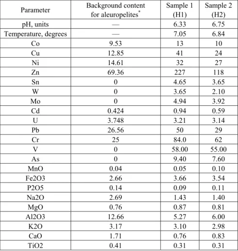
The chemical composition of bottom sediment, mcg/kg
Parameter Background content for aleuropelites*
Sample 1 ( 1)
Sample 2 ( 2)
, units — 6.33 6.75
Temperature, degrees — 7.05 6.84
Co 9.53 13 10
Cu 12.85 41 24
Ni 14.61 32 27
Zn 69.36 227 118
Sn 0 4.65 3.65
W 0 3.65 2.10
Mo 0 4.94 3.92
Cd 0.424 0.94 0.59
U 3.748 3.21 3.14
Pb 26.56 50 29
Cr 25 84.0 62
V 0 58.00 55.00
As 0 9.40 7.60
MnO 0.04 0.05 0.10
Fe2O3 2.66 3.66 3.54
P2O5 0.14 0.09 0.11
Na2O 2.69 1.43 1.40
MgO 0.76 0.87 0.81
Al2O3 12.66 5.27 6.00
K2O 3.17 3.10 2.98
CaO 1.71 0.76 0.83
TiO2 0.41 0.31 0.31
* The background contents for aleuropelites of the eastern part of the Gulf of Finland are based on the 2008 data of the A.P. Karpinsky National Geological Re-search Institute.
The pockmark bottom sediments have a significantly ferrous composi-tion in comparison to the background aleuropelites, as well as an increased content of almost all microcomponents.
medium of the incoming mineralised solution is slaked by highly oxidising marine water medium. It explains the increased content of Fe, which accumu-lates through the formation of organic polysulphides, clay minerals, etc.
One should mention that the sediments of the studied pockmark areas differ significantly in the composition and a number of components. So, the H1 pockmark sediments (sample 1) are rich in zinc and contain half as much Mn, i.e. are more oxidised. Apparently, this generation was exposed to local washing by sea water streams. This stream had more pronounced oxidising properties than the general marine medium, which accounts for the increased zinc content, which accumulated mostly through the sorption binding from sea water. The presence of a highly oxidising medium in the H1 pockmark area is confirmed by a lower, in comparison to the H2 pockmark, content of phtalate compounds (table 2).
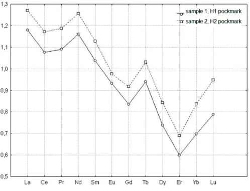
The analysis of lanthanides in the pockmark bottom sediment shows cer-tain patterns in the distribution of rare earths.
The geochemical properties of rare-earth elements (REEs) are an indicator of reduction-oxidation geochemical processes. Traditionally, their geochemistry was studied within the petrogenetic analysis of igneous rocks, however, over the last years, the patterns of their distribution in different aquatic geochemical sys-tems have been paid special attention to [8; 9; 13]. A study into the REE behav-iour in different types of surface and groundwaters [10; 11] that, in the general case, the surface and groundwaters can inherit the composition and properties of REEs from the rocks or other water mass they interact with.
Of special interest is the study into the influence of aluminium and iron hydroxide colloids in rivers, estuaries, and seawater on the processes of REEs fractioning (the correlation between the light (La-Nd), medium (Sm-Gd), and heavy (Tb-Lu) elements).
REEs are trivalent, with the exception of cerium (usually, 4+) and euro-pium (usually 2+), thus the behaviour of these elements in comparison with other REEs is used as an indicator of redox conditions. The geochemical pe-culiarities of europium lie in its variable valency: in the conditions of earth's surface, given a free access of oxygen, it is trivalent, as all other REEs, but in the heated depths of the planet, in the absence of free oxygen it reduces to the divalent condition and becomes more movable, penetrating the hydrothermal solutions circulating in rock fractures more intensively than other REEs.
However, europium can become divalent not only in the depths of the Earth, but also in the conditions of sediment reducing diagenesis accumulat-ing in developaccumulat-ing new formations.
The analysis of REE geochemistry regularly involves the use of concen-trations normalised to the North American Shale Composite (NASC) in order to exclude the influence of varying occurrence of chemical ele-ments (the even ones are more widespread than the odd ones). Another focus is the magnitudes of cerium and europium anomalies expressed as Ce*=3Cen/(2Lan+Ndn) [9, p. 216]; and Eu*= 2Eun/(Smn+Gdn), where "n"
indicated that the compositions are normalised to the NASC.
sed-iments. The mechanisms of REE (III) accumulation can be explained by the sorption/co-deposition of REEs in iron oxyhydrooxides.
In the course of diagenesis, the form of REE spectrum remains almost unchanged, which reflects the initial conditions of sediment accumulation.
In order to identify the conditions of sediment accumulations, we used the following tests for lanthanide composition estimation [7, p. 1104—1105]:
1) Σ(REE+Y);
2) La/Yb, La/Sm, Ce/Sm, Yb/Sm, Y/Sm facies environment indicators: in co-astal facies, the La/Yb, La/Sm, Ce/Sm values are increasing and those of Yb/Sm, Y/Sm are decreasing; the relation is inverse in deepwater and pelagial areas.
3) the climate indicator: Σ /ΣY, Σ :(La-Eu), ΣY:(Gd-Lu, Y), <2,5 — arid climate; 2,5—4,0 transitional conditions; >4 — humid climate;
4) the Ce*sedimentation condition indicator.
5) the Eu* sedimentation reducing condition indicator.
The contents of REEs, the magnitudes of cerium and europium anoma-lies and other geochemical coefficients in pockmark bottom sediments are given in table 4.
Table 4
The contents of REEs (mcg/g), the values of geochemical coefficients in pockmark bottom sediments
Parameter Sample 1 (H1) Sample 2 (H2)
La 37 40
72 78
Pr 8.72 9.50
Nd 32 34
Sm 5.80 6.31
Eu 1.10 1.15
Gd 5.31 5.83
Tb 0.80 0.88
Dy 4.06 4.64
Er 2.25 2.59
Yb 2.13 2.56
Lu 0.36 0.43
Y 19 19
Ce* 0.94 0.94
Eu* 1.02 0.95
LREE/HREE 10.46 9.99
Σ(REE+Y) 189.77 204.96
Σ /ΣY 5.64 5.81
The spectra of REE distribution (fig. 3) are homogenous for the studied sediments and are characterised by the excessive content of light lanthanides and the deficit of the heavy ones, which is not typical of marine sediment that exhibits the opposite pattern, and is characteristic of continental sedi-ments. The cerium anomaly is negative (fig. 3), its values correspond to the pericontinental sedimentation conditions [7, p. 1104].
Fig. 3. The spectra of REE distribution (REE contents normalised to the NASC)
The La/Yb, La/Sm, Ce/Sm, Yb/Sm, Y/Sm values correspond to those of coastal facies [6, p. 75]. Relatively high La/Yb, La/Sm, Ce/Sm values may be explained by the influence of the meteoric solution to the pock-mark area.
The ΣCe/ΣY values correspond to the humid rock formation type. A decreased and close to the clarke values for NACS (199 mcg/g) concen-tration of Σ(REE+Y) is detected against the background of an increase in the sum with a high organic concentration in the sample.
The observed distribution of lanthanides corresponds to the low sedi-mentation rates [4]. Eu* exceeds the average value in the Phanerozoic sedimen-tary rocks (Eu/Eu* = 0.61—0.72) [7, p. 1105]. Such Eu* value proves the pres-ence of a boundary zone of redox barrier at the bottom sediment-water in the pockmark area.
Table 5
The species composition of benthos and the biomass distribution
Species Genus
Sample 1 (H1) Sample 2 (H2) Abundance,
specimens/m2
Biomass, g/m2
Abundance, specimens/m2
Biomass, g/m2
Saduria entoma Crustacea 10 0.2 10 8
Spionidae Polychaeta 430 0.75 800 3,9
Oligochaeta Oligochaeta 30 0.1 70 0,3
Amphipoda Crustacea 30 0.15 20 0,12
Macoma baltica Bivalvia 10 1.45
Total 510 2.65 900 12.32
Polychaeta 28%
Bivalvia 54%
Crustacea 8%
Oligochaeta 4% Crustacea
6%
Crustacea 65% Polychaeta
32%
Oligochaeta 2%
Crustacea 1% Bivalvia
0%
ɚ ɛ
Fig. 4. The species composition of benthos and the biomass distribution: a — the share of biomassin sample 1; b — the share of biomass in sample 2
The basic part of biomass is comprised by the Saduria entoma isopods and Macoma baltica molluscs, the most abundant organisms are polychaetes. Samples exhibited radical difference both in the abundance of taxa and the degree of their dominance. Such variety in a small area indicates the dis-creteness of benthos organism distribution.
At the same time, the data obtained are comparable with those given in various publications. So, the distribution of most macrobenthos species (40 in total) is limited in the lagoon to shallow-water well-heated areas, while the others are inhabited by only several species, mostly relict crusta-ceans. In the coastal part of the Koporye Bay at a depth of 14—29 m, the macrozoobenthos biomass reaches 0.04—1.34 g/m2 [5, p. 429].
of a solution of a different than seawater salt composition and the presence of a boundary zone of redox barrier at the sediment —water border in the pockmark area creates spots of anomalous microenvironment and influences the composi-tion and development of benthos.
Conclusion
On the basis of the above materials, one can arrive at the following conclusions. 1. The increase in the background concentrations of major cations and ani-ons in near-bottom waters of the pockmark area (increased salinity) is apparently a sign of the filtration of water with a different from seawater salt composition.
2. The comparison of iron and manganese distribution in the near-bottom waters and pockmark sediments and the analysis of lanthanide distribution in the bottom sediment indicates that the bottom pockmark sediments belong to the boundary zone of geochemical barrier, where the redox medium of incoming mineralised solution is slaked by the highly oxidising seawater medium. The high-ly oxidising environment in the H1 pockmark area is confirmed by a lower in comparison to the H2 pockmark contents of stable organic compounds.
3. The filtration of a solution of a different than seawater salt composition and the presence of a boundary zone of redox barrier at the bottom sediment-water border within the pockmarks creates spots of anomalous microenvironment and affects the composition and development of benthos.
4. Despite the data obtained indicating the filtration of a mineralised solution in the pockmark area, the problem of their origin remains unsolved and requires further research. To this effect, first of all, it is necessary to sample and study deeper bottom sediment horizons.
References
1. Geodekjan, A. A., Trocjuk, V. Ja. 1979. Okeanologij, Vol. 19, №4,
pp. 638—643.
2. Geodekjan, A. A. (Ed.). 1990. Geoakusticheskie i gazo-litogeohimicheskie
is-sledovanija v Baltijskom more. Geologicheskie osobennosti rajonov razgruzki fljuidnyh potokov. Moskow, pp. 81—93.
3. Geodekjan, A. A. 1997. Geohimija vod i donnyh osadkov Baltijskogo morja v
ra-jonah razvitija gazovyh kraterov i geoakusticheskih anomalij. Moskow, pp. 101—117.
4. Balashov, Ju. A. 1976. Geohimija redkozemel'nyh jelementov. Moskow.
5. Ljahin, Ju. I., Makarova, S. V. 1997. Jekologicheskaja obstanovka v
vostoch-noj chasti Finskogo zaliva v ijule 1996 goda. In: Davidan, I.N., Savchuk, O.P. Prob-lemy issledovanija i matematicheskogo modelirovanija jekosistemy Baltijskogo morja. Vol. 5: Jekosistemnye modeli. Ocenka sovremennogo sostojanija Finskogo zaliva. St. Petersburg, pp. 416—434.
6. Shatrov, V. A., Vojcehovskij, G. V. 2010. Vestnik VGU. Ser. Geologija, №1,
pp. 73—83.
7. Shatrov, V. A., Vojcehovskij, G. V. 2009. Geologija i geofizika. Part. 50,
№10, pp. 1104—1118.
8. Elderfield, H. 1988. The oceanic chemistry of the rare-earth elements. Phil.
9. Elderfield, H., Greaves. M. J. 1982. The rare earth elements in seawater. Na-ture. London. V. 296, pp. 214—219.
10. Fee, J. A., Gaudette, H. E. et al. 1992. Rare earth element distribution in the
Lake Tyrrell groundwaters, Victoria, Australia. In: W. B. Lyons [et al.] The Geochem-istry of Acid Groundwater Systems. Chem. Geol., V. 96, pp. 67—93 (special issue).
11. Gosselin, D. G., Smith, M. R. et al. 1992. Geochim. Cosmochim. Acta,
V. 56. P. 1495—1505.
12. Gromet, L. P., Dymek, R. F. et al. 1984. Ibid. V. 48, pp. 2469—2482.
13. Johannesson, K. H., Stetzenbach, K. J. et al. 1997. Ibid, V. 61, №17,
pp. 3605—3618.
About authors
Dr Varvara Ivanova, Leading Research Fellow, I. S. Gramberg All-Russian
Re-search Institute of Geology and Mineral Resources of the World Ocean. E-mail: [email protected]
Dubrava Kirievskaya, engineer, I. S. Gramberg All-Russian Research Institute
of Geology and Mineral Resources of the World Ocean. E-mail: dubrava. [email protected]
Alexander Bolotov, engineer, I. S. Gramberg All-Russian Research Institute of