Property regimes and the
commodification of geographic
information: An examination
of Google Street View
Luis F Alvarez Leo´n
Abstract
The body of information on the Internet is becoming increasingly geographical. This is both due to the expansion of established categories of geographic information (e.g., digital maps and geospatial databases) and to the simultaneous enrichment of other types of information through geographic identifiers (e.g., geotags, check-ins, and global positioning system coordinates). As this repository of geographic information expands, it is also a key site for multiple processes of commodification transforming informational resources into market goods. Understanding the dynamics driving the integration of geographic information into the digital economy requires a comprehensive political economic analysis. A key component of this analysis is to explain the logics of creation and allocation of economic value from geographic information on the Internet. Addressing this need, in the present article I deploy the property regimes schema developed by Schlager and Ostrom and expand it to elucidate the differentiated commodification processes of geographic informa-tion on the Internet. Property regimes are arrangements that define rules, distribute rights, and delineate roles with respect to particular goods. These arrangements are enabled by elements such as legal frameworks, jurisdictions, type of information, and technologies of access. In this article, I explore how the legal frameworks regulating traditional categories of geographic information (such as maps) have been destabilized in the process of technological innovation, leading to the creation of new informational goods along with their respective property regimes, and rearticulating legal, economic, and sociotechnical relations. To illustrate this, I analyze the case of Google Street View images through their property regimes in various jurisdictions.
Keywords
Geographic information, geoweb, property regimes, commodification, digital economy, Google Street View
Introduction
The overarching goal of this article is to analyze and explain the commodification of geographic information on the Internet by examining the property regimes that emerge in this process. Property regimes are ways of organizing diverse bundles of rights with respect to a specific resource. These rights are the product of rules, which define how they can be allocated to particular actors, which in turn creates roles with specific func-tions within the property regime.
A well-defined conceptual schema of property regimes can help sharpen the analysis and management of resources and their economic exploitation. In this
article, I mobilize the schema developed by Schlager and Ostrom (1992) and extend it to analyze the com-modification of digital geographic information on the Internet. The goal is to produce a more finely grained understanding of how geographic information is inte-grated into the digital economy. This analysis begins by
Department of Geography, University of California, Los Angeles, CA, USA
Corresponding author:
Luis F Alvarez Leo´n, Department of Geography, University of California, Los Angeles, 1255 Bunche Hall, PO Box 951524, Los Angeles, CA 90095, USA.
Email: [email protected]
Big Data & Society July–December 2016: 1–13
!The Author(s) 2016 Reprints and permissions: sagepub.com/journalsPermissions.nav DOI: 10.1177/2053951716637885 bds.sagepub.com
exploring how the digitization of geographic informa-tion has destabilized and reconfigured property regimes from established informational categories such as maps and databases.
Through the lens of property regimes, I explore the interactions and configurations between actors, tech-nologies, and institutional frameworks that both enable and result from the creation of market goods through digitized geographic information. Furthermore, by showing the diverse dynamics of com-modification, this article contributes to the necessary task of building a richer political economy of geo-graphic information on the Internet (Elwood and Leszczynski, 2012; Leszczynski, 2012) that ‘‘goes beyond the geotag,’’ or transcends the locative aspects of geographic information and analyzes its contextual elements in greater depth (Crampton et al., 2013).
By organizing the allocation of rights over resources, property regimes also articulate social relations among actors. This process is mediated by technologies tai-lored to specific types of resources and individual goods. Such technologies are used to grant access to and monitor the use of the resource, as well as to define, allocate, and regulate the rights specific to each particular role. Technology thus plays a key role in the allocation of rights to a resource and therefore its management, exploitation, and commodification. For example, a fishery will require management technolo-gies quite different from digital systems controlling access to copyrighted digital content. New kinds of property rights management technologies have prolif-erated in digital information environments. Some examples of these include anti-piracy digital rights man-agement software (DRM), password protection, region encoding, and subscription charges, among many others. Following the widespread imperative to extract profit from information, the digital economy is increas-ingly characterized by the use of rights management technologies in the context of monetary exchanges.
However, in digital environments, the technologies used to access, manage, and commercialize information often go unnoticed or appear ‘natural’ to many users. In his discussion of the ‘disburdenment’ of human intel-ligence from the context of experience, Borgmann (2000) cautions that the increasing complexity of med-iating technologies often obscures the nature of the social relations they articulate. Building on this insight, the property regimes analysis advanced in this article contributes to a political economy of digital informa-tion that tackles the power dynamics, socioeconomic relations, and technological configurations behind an economy of digital information—which, despite its physical expressions (Blanchette, 2011) and infrastruc-tural requirements (Blum, 2012), is often abstracted into an immaterial ‘‘cloud’’ (Mosco, 2014) and
characterized as ‘‘bits’’ rather than ‘‘atoms’’ (Negroponte, 1995).
A crucial instance of this mediation is the techno-logical composition of information, or how specific technologies and formats shape its structural features. Since technology and information are inseparable from the rest of the social world, the technological compos-ition of information is influenced by socioeconomic relations (Pinch and Bijker, 1984) and simultaneously impacts them (Winner, 1993). This mutually constitu-tive relationship has important implications for the construction of property regimes of digital geographic information. An illustrative case in point is the contrast between digital and print information technologies. In the last four decades, increased digitization has entailed a sweeping disruption of long-established information practices and categories. The emergence of new media to store and display information has transformed sig-nificantly how goods are categorized in law and prac-tice, affecting the rules regulating their economic exploitation. These reconfigurations of rules, technolo-gies, and practices have created new property regimes for the management and economic exploitation of informational goods.
The growing repository of geographic information on the Internet (often referred to as the ‘geoweb’) is the result of cumulative technological innovations such as social media, the exponential increase in pro-cessing speed, widespread cloud storage, and the emer-gence of server-side web-mapping (Tagoe and Mantey, 2011). These technological developments, along with the economic imperatives to commercialize geographic information, the regulatory frameworks of particular informational categories, and territorial jurisdictions at different scales jointly articulate the property regimes of geographic information. Analyzing how these property regimes come together is an important step towards understanding the commodification affecting digital geographic information, as well as the broader political economy in which it develops.
the process rearticulates processes of commodification. I then deploy the property regimes schema to analyze the commodification of geographic information in the case of a good that is a result of the integration of different types of geographic (and non-geographic) information in a networked digital environment: Google Street View. The analysis shows the various types of rights attached to each component of this good, the allocation of these rights, and the manage-ment technologies that mediate this process. One important implication is that the integration of different kinds of information and the emergence of new prop-erty regimes in the process of commodification often creates tension between sets of values and logics, which often transcend property rights understood in isolation. A key example of this is privacy rights. As I show in the case of Google Street View, information that points to location and context must inevitably con-sider the aspects of privacy that arise from its collection and distribution. I conclude the analysis of the com-modification of Google Street View by exploring how shifting notions and new constructions of privacy are deeply constitutive of the creation of new geographic information products and the property regimes that come together in this process.
Property regimes and the
commodification of
geographic information
The expansion of geographic information on the Internet should be understood in the context of a wider political economy characterized by the increasing reliance of capitalism on immaterial, symbolic, cognitive-cultural, and informational goods (Lash and Urry, 1994; Schiller, 2000; Scott, 2007), as well as by the dramatic growth of the digital economy (Ng, 2014; Sobel, 2003; Vafopoulos, 2011; World Economic Forum and Boston Consulting Group, 2013). This het-erogeneous body of informational products includes commercial databases as well as resources whose pri-mary purpose is not necessarily commercial, such as public information repositories, like the US Census Bureau’s American Fact Finder, and collaborative pro-jects like OpenStreetMap. The capabilities of geo-graphic information to provide location and context have fueled its growing demand in a wide range of activities, from retail and advertising to political cam-paigning (Henttu et al., 2012; World Economic Forum and Boston Consulting Group, 2013). In this expanding economy of geographic information, the lines between commercial and non-commercial products are continu-ously redrawn, and their property regimes reconfigured. Commodification, or the process of creating goods for the market, implies the delineation of property
rights suitable for economic exchange. However, prop-erty rights must function within a broader infrastruc-ture that includes legal, political, and technological arrangements. Radin has called this ‘‘the legal infra-structure of private-property-plus free contract’’ (Radin, 2002). This draws attention to the mutual con-stitution of property rights with social and incon-stitutional relations that emerge from and regulate the use, own-ership, and exchange of any particular good.
Digital information has posed particular challenges for the definition of property rights. Samuelson identi-fied six characteristics of digital media that challenge and disrupt existing intellectual property systems: (1) ease of reproduction, (2) ease of transmission, (3) ease of modification and manipulation, (4) equiva-lence of digital works, (5) compactness of digital works, and (6) new methods of searching and linking digital works (Samuelson, 1990). These challenges to existing notions of property rights become even more acute in networked information environments. Overcoming them is a key requirement for the digital economy, which increasingly relies on the monetized exchanges over the Internet. This has led to new approaches in the allocation of distributed property rights. Often these take the form of technical solutions such as the information controls and DRM systems mentioned above. These systems have prompted discussions (Becker et al., 2003) regarding their role in privatizing copyright (Lessig, 1999), narrowing property rights (Cohen, 1998), overreaching intellectual property enforcement (Samuelson, 1999), and even their futility in the face of alternative distribution networks – such as peer-to-peer sharing (Biddle et al., 2003).
In challenging and redefining the property rights enforcement, digital technologies have produced new configurations of social relations, institutions, and tech-nologies that come together in various ways for the commodification of particular informational goods. This requires analyses able to integrate the allocation of rights with the commodification of digital informa-tional goods into the multiple dimensions at which these take place: infrastructural (e.g., cables, server farms, terminals), geographical (e.g., territorial jurisdic-tions, borders), informational (e.g. information man-agement technologies and governance regimes of specific informational categories).
world, in total exclusion of the right of any other indi-vidual in the universe’’ (Blackstone, 1893: 304). While Blackstone’s analysis of property rights was more nuanced than his definition would suggest (Schorr, 2009), the underlying idea of a ‘‘sole and despotic dominion’’ ‘‘rings through the ages, and continues to block clear thinking about private property’’ (Heller, 2000: 418). This idea of private property has been com-plemented by two additional categories to settle into what Michael Heller calls the ‘‘well-worn trilogy of ownership forms –private, commons, and state prop-erty’’ (Heller, 2000: 418). The first category refers to property owned by particular individuals (or families or firms); the second, by no one in particular; and the third, by the state (Heller, 2000: 418). Yet while this classification broadens the idea of property to associate it with different actors, it does not reflect the diversity of arrangements that exist in practice.
An alternate conception of property, which chal-lenges absolutist and individualistic notions, is that of a ‘‘bundle of various rights, liberties, and powers that can be divided among many parties in numerous ways’’ (Gaus, 2012: 94). Taking this conception as a point of departure, (Elinor and Vincent) Ostrom, along with other scholars of the Bloomington School of Political Economy, developed a systematic approach to the distribution of property rights, the analysis of their different configurations in practice and their the-oretical synthesis. A particularly useful and versatile tool among these contributions is the conceptual schema proposed by Schlager and Ostrom ‘‘for array-ing property-rights regimes that distarray-inguishes among diverse bundles of rights ranging from authorized user, to claimant, to proprietor, and to owner’’ (Schlager and Ostrom, 1992: 249).
This schema enables an organized analysis of how bundles of rights are distributed in the management of
a resource system. In this context, ‘‘rights’’ refers to ‘‘particular actions that are authorized,’’ which are allo-cated to different ‘‘roles.’’ ‘‘Rights’’ are the product of ‘‘rules,’’ or the prescriptions that create certain author-izations (Schlager and Ostrom, 1992: 250). Rules refer to three different levels of action: operational, collective-choice, and constitutional. Schlager and Ostrom explain the distinction between the first two categories as ‘‘the difference between exercising a right [operational] and participating in the definition of future rights to be exercised [collective-choice]’’ (Schlager and Ostrom, 1992: 251). The third level of action (constitutional) is where collective-choice rules are defined. The schema proposed by Schlager and Ostrom focuses on the organization of the first two levels of action in a prop-erty regime: the rules that create certain rights, and the roles defined by the allocation of those rights to par-ticular actors. These elements, which together consti-tute any given property regime, are represented in Table 1.
The property regimes schema illustrated by Table 1 is comprised by two levels of action (operational and collective-choice), five rights (access, withdrawal, man-agement, exclusion and alienation), and four roles (authorized user, claimant, proprietor, and owner) (Schlager and Ostrom, 1992: 249). The incremental allocation of rights to different roles shows how prop-erty rights can be disaggregated and distributed in a variety of ways. In this arrangement, the authorized user has the least rights (access and withdrawal) and the owner has the most (full set of property rights, including alienation). While the owner’s full set of property rights echoes the Blackstonian definition property discussed above, a key insight from Schlager and Ostrom is that owners are not the only users who ‘‘make long-term investments in the development of resource systems’’ (Schlager and Ostrom, 1992: 249).
Table 1. Elements of a property regime. Compiled by author with information from (Schlager and Ostrom, 1992: 250-252). Level of action Operational Operational Collective-choice Collective-choice Collective-choice
Right (definition)
Access (The right to enter a defined physical property)
Withdrawal (The right to obtain the ‘‘products’’ of a resource – e.g. graze lands)
Management
(The right to regulate internal use patterns and transform the resource by making improvements)
Exclusion (The right to determine who will have an access right, and how that right may be transferred)
Alienation (The right to sell or lease either or both of the above collective-choice rights)
Role Authorized
User
X X
Claimant X X X
Proprietor X X X X
This is consistent with the more general insight that there is no ‘‘one size fits all’’ model of property regimes which consistently produces ‘‘better’’ outcomes, but rather a multiplicity of ways to manage the rights over resources without over-exploiting them (Ostrom, 1990, 2010). This has been the basis for theoretical developments on property and resource management encapsulated by ‘‘Ostrom’s Law’’: ‘‘a resource arrange-ment that works in practice can work in theory’’ (Fennell, 2011: 9). One of these developments has been to explore the construction of knowledge as com-mons (Hess and Ostrom, 2007). Seeking to complement this body of work, the present article analyzes a move-ment in the opposite direction of knowledge commons: the commodification of digital geographic information on the Internet.
Coexisting in a networked environment, repositories of government-produced, privately collected, and vol-unteered geographic information (among other types) are increasingly recombined to produce new market and non-market goods. Each of these informational inputs is often governed by different regulatory frameworks, which are articulated in the development of new property regimes. For example, as is discussed later in the article: the privacy rights related to the collection images and wireless data during the creation of Google Street View have brought this prod-uct under a regulatory framework not applied previ-ously to traditional maps. This highlights why the political economy of geographic information requires a detailed and contextualized understanding of the new property regimes that emerge in the process of commodification.
Specifically in the case of geographic information, Cho advances a notion compatible with ‘‘bundles of rights’’: layers of property rights over geographic infor-mation, which have a technical basis on the model of superimposed datasets used by most Geographic Information Systems (Cho, 2005: 135). While ‘‘bundles of rights’’ can be thought of as a ‘‘vertical’’ allocation of partial rights over an entire good, ‘‘layers of rights’’ in geographic information suggests a ‘‘horizontal’’ div-ision. The coexistence of these in electronic maps and other geographic informational goods shapes negoti-ations in the rights attached to discrete sets of informa-tion superimposed on each other, but which may each have diverse origins and property regimes. This is a feature that makes digital cartographic products sub-stantially different from print maps, which only showed the graphic output of a specific arrangement of infor-mation, while concealing the layers of input required in their production. When digital maps and other types of geographic information are uploaded to the Internet, these complexities are intensified because they become part of an informational environment with great
potential for widespread distribution, accessibility, and recombination.
Considering digitized geographic information, this article extends Schlager and Ostrom’s property regimes conceptual schema by focusing on three key elements to analyze commodification of geographic information: (1) the role of information technologies (such as the technological composition of particular informational goods, and technologies of access and management, – e.g., application programming interfaces, or APIs), (2) the specific features of digitized geographic informa-tion, such as the six features of digital media identified by Samuelson above, and the information layers char-acteristic of geographic information, and (3) the inter-section and conflict between different logics and values resulting from the combination of informational inputs in the production of digital goods – such as issues with property and privacy rights discussed in the case of Google Street View. Together these elements shape the commodification of digital geographic information goods, by modulating the allocation of rights over them and articulating new property regimes.
The property regimes of geographic information and its commodification take shape within a broader polit-ical economy affected by the changing role of the state in the collection and provision of geographic goods. On the one hand, many national and subnational adminis-trations are adopting ‘‘open data policies’’ (Huijboom and Van den Broek, 2011). On the other hand, there is a ‘‘roll back’’ by different governments away from previ-ously publicly provided functions and services, which impacts the production of geographic information (Leszczynski, 2012). This retreat has produced at least two concurrent developments. Firstly, it has transferred mapping capabilities to private corporations and com-munities of users. This transfer has occurred explicitly through outsourcing and subcontracting, or implicitly through passive non-competition and the creation of market spaces for the development of a geographic information industry. In the past decade, this process has been accelerated by the availability of web-based mapping technologies. Secondly, this process has reori-ented state capacity towards intensifying the publicly funded collection and production of restricted-access geographic information, much of it towards the swel-ling surveillance and security apparatus of various states (Crampton, 2014; Crampton et al., 2014; Howard et al., 2011).
and focus on the transition from print to digital maps. This lays the groundwork for analyzing the commodi-fication of a particular digital geographic information good: Google Street View.
From maps to databases
To illustrate the interdependence between technological change and property regimes in the context of geo-graphic information, consider an example that predates – and prefigures – developments in the ‘‘geoweb’’: the transition from paper to electronic maps. Since the appearance of Geographic Information Systems in the 1960s, the focus on hand-drawn paper maps as products of the cartographic process has shifted towards the dynamic manipulation of different kinds of geographic information through innovations in computing and geographic information technologies (Cartwright and Peterson, 2007; PF Fisher, 1998). These changes in cartography, geographic information management, and their widening range of applications have fueled an industry with an estimated $USD 75 billion in global revenue in 2012 (Oxera, 2013) and a multiplier effect of $USD 1.6 trillion in U.S. economic growth (Henttu et al., 2012). The digitization of maps and computerization of the cartographic process have also redefined geographic information. This epistemic shift is at the crucible of significant legal changes, such as the emergence of new property regimes involved in the management and commodification of geographic information.
In the United States, maps have been a protected
category under Copyright Law since the first
Copyright Act (Copyright Act of 1790, 1790).
However, the term ‘‘map’’ is no longer a stable cat-egory. For the first two centuries of US Copyright Law, while there were intermittent arguments regard-ing what constitutes originality in a map –a require-ment for copyright protection – (Whicher, 1963) – these were not focused on the question of whata map
is. Maps were tacitly understood in the legal context as pictorial representations of spatial information. The increased production of maps by digital geographic information systems has destabilized the legal consen-sus governing the definition of these objects and the protections granted to them.
Copyright Law considers maps the pictorial outputs of the cartographic process. However, maps are increasingly defined not by their pictorial aspects, but by the informational inputs and operations involved in their production. This technological shift has recali-brated the economic valuation of maps. Geographic Information Systems enable the organization, analysis, and transformation of spatial data while making the creation of graphical maps a secondary task.
Consequently, the value attributed to the mapping pro-cess has shifted to the increasingly complex databases of spatial information and the techniques used to extract meaningful patterns from them. With the expansion of ‘‘big data’’ (Kitchin, 2014a, 2014b; Mayer-Scho¨nberger and Cukier, 2013), the database components of maps have found ever wider applica-tions (e.g., real-time enhanced navigation such as Waze, and geo-targeted advertising) and market poten-tial relative to the graphical component of maps.
Notwithstanding the growing economic value of databases, contrasting degrees of protection are offered to the pictorial and informational components of digi-tal maps. Whereas pictorial maps are still protected by Copyright Law, databases are subject to a more con-tested legal regime (Reichman and Samuelson, 1997). The US Supreme Court decision on the case of
Feist v Rural in 1991 established that databases are not de facto protected by copyright because they are considered compilations of facts. This ruling disquali-fied databases from automatic protection for two main reasons: Firstly, facts themselves cannot be copy-righted. Secondly, compilations do not necessarily meet the minimum threshold of creativity required to be considered original expressions (Feist Publications, Inc. v. Rural Telephone Service Co., 1991).
The Feist verdict was reached by concluding that Feist Publications’ copy of over 1000 entries from a telephone directory published by Rural Telephone Service did not imply a copyright violation. While the origins of this ruling may seem rooted in a different era, its resonance for the digital economy has become sig-nificant due to its impact on the protection of databases compiled in any medium. In the context of geographic information, this implies a discrepancy in the property regimes of the different informational components of the map that has not been fully resolved and is expected to continue generating debates in the courts.
Furthermore, this decision has generated new ways of managing the value of maps and allocating rights to their use and commercialization. However, since the underlying databases are not de facto protected by copyright, this opens the door for increased use of con-tracts (Karjala, 1995) or hybrid sui generisprotections, both of which may be much more restrictive than the most stringent copyright protections and have signifi-cant anti-competitive effects while constraining access to essential inputs for knowledge creation (Reichman and Samuelson, 1997).
Street View, a new type of geographic information pro-duct in the context generated by the technological and regulatory rearticulations discussed above.
Constructing Google Street View’s
property regime
The commodification of Google Street
View images
Released in 2007, the Google Street View platform was not the first service to show a map with linked photo-graphs for specific locations: Amazon launched the short-lived BlockView in 2005 and Microsoft’s Streetside appeared in 2006. Yet Google Street View soon developed competitive advantages through exten-sive primary data collection by Google vehicles and integration with Google Maps and Search platforms. This allowed Google Street View to produce a compre-hensive and navigable virtual environment. Initially launched in five cities (San Francisco, New York, Las Vegas, Miami and Denver), it now covers 3000 cities in 54 countries and is expanding to cover features such as the Amazon and the Grand Canyon (Fisher, 2013).
The development of Google Street View also entailed the production of new cartographic perspec-tives. These perspectives signaled not only new ground in cartographic representation, but also shift in image processing and delivery technologies, as well as new modes of user engagement with digital maps. An element of this is the innovation of the R5 and R7 rosette cameras, which are mounted on Google vehi-cles, and can produce a continuous 360-degree panora-mic high-resolution digital environment (Anguelov et al., 2010). As mentioned above, another element is the integration of this virtual environment into Google Maps and Search (Vincent, 2007). This enables users to navigate space by transitioning between the carto-graphic ‘‘view from above’’ provided by Google Maps, with its turn-by-turn navigation interface (which directs drivers at each step of their route), and the virtual landscape of Google Street View with its reproduction of the street-level point of view, of the car or pedestrian (Anguelov et al., 2010). These features are further enhanced by the inclusion of satellite layers on the Google Maps and with the separate release of the Google Earth application.
Beyond contributing to Google Maps’ hegemony of general-purpose web-mapping service and mobile navi-gation applications (Smith, 2013), the significance of Google Street View lies in blurring the lines between digital maps, navigation services, and virtual environ-ments. This results from expanding the scale (millions of images), scope (growing coverage), perspective (ground level linked to view from above), and usability
(navigation function and articulation with search) of digital maps on the Internet. By integrating these elem-ents into a consumer product which users can access through tiered service (involving both informational and monetary exchanges), Google has engaged in per-haps the most thorough and expansive commodifica-tion of geographic information ever attempted. Since the tiers of service provision correspond to sets of rights transferred to users in various types of exchanges, a property regimes analysis through an extension of Schlager and Ostrom’s (1992) schema can help illuminate how Google Street View and Google Maps commodify geographic information.
A first step in the commodification of geographic information is securing the property rights for the digi-tal images in Google Street View for their assembly into a virtual environment. This constitutes a process of landscape production. According to Cosgrove, since its inception in Renaissance Europe, landscape as a ‘‘way of seeing’’ has achieved ‘‘the control and domin-ation over space as an absolute, objective entity, its transformation into the property of individual or state’’ (Cosgrove, 1985: 46). Landscape production was bound up with activities of power, control, and strategic domination of space such as survey and mapping of estates by the urban bourgeoisie, defensive fortification, and cartographic projection (Cosgrove, 1985: 46). Google Street View’s particular production of landscape involves the gradual accumulation of geo-graphic information into a new market commodity: a virtual navigation platform which users pay (through monetary or informational exchanges) to access, use, and manage various functions ranging from explor-ation to API use by third party applicexplor-ations.
Elements of the environment, such as buildings, streets and parks, are framed and captured as land-scapes when they are fixed on a visual medium. In Cosgrove’s terms, this is the point when each photo-graphic image is ‘‘produced by the sovereign eye,’’ into a landscape where ‘‘space is rendered the property of the individual detached observer, from whose location it is a dependent, appropriated object’’ (Cosgrove, 1985: 48–49). This singular perspective is modified by the personalized production of landscapes enabled through the customized views offered by Google Street View.
vehicles. As will be discussed below, regulators have shown that Google vehicles collect wireless communi-cations data from private wireless networks in the course of taking Google Street View photographs. This brings an added layer of complexity to the prop-erty regime of Google Street View because wireless communications (and the private information therein) fall under a different regulatory framework to photo-graphs. This highlights how privacy issues have become increasingly intertwined with the commodification of geographic information in the digital economy.
While Google Street View is a result of commodifi-cation through landscape creation, each individual landscape image has negligible value for Google. The value creation of Google Street View takes place through the massive integration of individual images into a navigable virtual environment. Google Street View is then made into a commodity through the accu-mulation of millions of infinitesimally valuable proper-ties, which are assembled into a coherent, fully interactive virtual ‘‘landscape of landscapes.’’ This product only accrues value once it is functional and released online for users to navigate it. This value is fully realized when different kinds of users interact with the features of Google Street View and Maps through monetary and/or informational exchanges.
There are two kinds of users for Google Street View and Maps: first, the advertisers, who pay to have their ads shown on the map itself. Second: the end users of the maps and the map API. For the advertisers, Google Street View and Maps represent a way to reach and research geographically targeted market segments at increasingly more detailed scales. On the other hand, end users have a variety of interactions with this prod-uct that include monetary and non-monetary transac-tions and range from exploration and navigation to
service provision through the use of the Google Maps API in third party applications.
The first tier of end users engages in a non-monetary transaction involving the collection of their search information by Google in exchange for the use value provided by Google Street View: navigation directions and detailed place-based information. A second tier of users (Standard API users) can integrate the Google Maps API, which includes Google Street View, into their own online services. The paid service for this tier includes a volume of 25,000 map load requests per day for a period of 90 consecutive days. For requests exceeding this limit, there is a third tier of service (Premium API users), which charges according to the volume of requests (Google, n.d.). For users to inte-grate the Google Maps API into their services, access must be open to the public and free of charge, unless an exception is explicitly specified in the agreement with Google (Google, 2015).
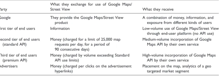
In these transactions, governed by licenses, users provide information or money in exchange for different uses of the Google Street View and Maps. Through this triangular exchange between advertisers, end users, and Google (through Google Maps/Street View and Google Search), the commodity realizes its value in different ways for the three parties involved. The users receive the service of navigation and exploration (for first tier end users), or a product that they can incorporate into their own applications (for second and third tier API end users); Google receives a combination of users’ information, money, and the diffusion of their product through third party services (API users). Google then uses this information to sell search engine and map space to advertisers, who in turn receive increased exposure. These exchanges are summarized in Table 2.
Table 2. Exchanges in the commodification of Google Street View.
Party
What they exchange for use of Google Maps/
Street View What they receive
Google They provide the Google Maps/Street View product
A combination of money, information, and exposure from different kinds of users First tier of end users Information Low-volume use of Google Maps/Street View
through end-user platform (no API use) Second tier of end users
(standard API)
Money (charged for a limit of 25,000 map requests per day, for a period of 90 consecutive days)
Medium-volume incorporation of Google Maps API by their own service
Third tier of end users (premium API)
Money (charged by volume exceeding Standard API use limits)
High-volume incorporation of Google Maps API by their own service
Advertisers Money (charged per clicks on the advertisement hyperlinks)
Placement on the map, analytics of a geo targeted market segment
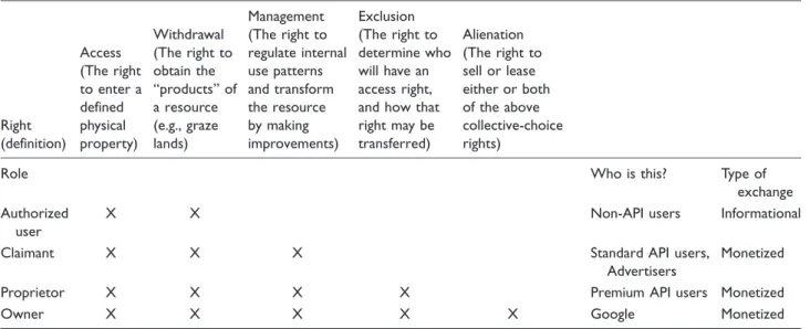
The production of the Google Street View environ-ment and its appropriation of images into landscapes presents two related concerns that play a fundamental role in shaping the property regime of this commodity: property and privacy. Above I discussed the construc-tion of property through the allocaconstruc-tion of specific rights as a result of monetary and non-monetary exchanges. These exchanges in turn create roles that come together to form a property regime specific to Google Street View images. Table 3 summarizes these exchanges and the rights assigned through to them to various roles, using the terminology of Schlager and Ostrom (1992). In the following subsection, I turn to the role of privacy in the creation of a property regime specific to Google Street View.
The role of privacy in Google Street View’s
property regimes
In the preceding subsection, I outlined two key issues in the creation of a property regime for Google Street View: property and privacy. The technological means of imagery collection and the very nature of the Google Street View platform make these concerns increasingly difficult to disentangle. In this context, the second con-cern, privacy, stems initially from the capture of Google Street View images as well as from the degree of inva-sion of someone’s private sphere implicated by this action. Since this is a service offered in many countries, the property regimes shaping its commodification will vary across jurisdictions. These variations affect the product itself. For example, the information included on the map can change due to geopolitical
considerations, and the various privacy regulations can restrict the collection of certain data. While there are many factors that may influence the local configur-ation of these property regimes, a key indicator is the relative weight given in each case to the privacy and property of the images and information involved in the triangular exchange (users – Google – advertisers) explained above.
In order to discuss the privacy implications of Google Street View imagery collection, it must be noted, as Elwood and Leszczynski have done (2011) that the geoweb has catalyzed a reconceptualization of privacy, as well as the associated social (and legal) struggles to define, maintain, and protect it. The fact that large datasets and imagery can be directly linked with particular physical locations creates a qualitatively different context in which to discuss what privacy means and how it is constructed. As Google Street View and other products in the geoweb have shown, large and networked datasets are becoming associated with spatial presence in ways that were unavailable to purely textual, tabular, or numerical data. This funda-mentally alters the position and relations between actors who produce, access, use, or control these data (Elwood and Leszczynski, 2011). These relations are technological as much as they are institutional, polit-ical, and economic.
In the case of Google Street View, the production of this digital commodity must negotiate shifting concep-tions of privacy, which are further transformed by the very act of imagery collection. In the course of collect-ing imagery, Google Street View vehicles physically navigate public thoroughfares. However, the public
Table 3. A property regime for Google Street View.
Right (definition)
Access (The right to enter a defined physical property)
Withdrawal (The right to obtain the ‘‘products’’ of a resource (e.g., graze lands)
Management (The right to regulate internal use patterns and transform the resource by making improvements)
Exclusion (The right to determine who will have an access right, and how that right may be transferred)
Alienation (The right to sell or lease either or both of the above collective-choice rights)
Role Who is this? Type of
exchange Authorized
user
X X Non-API users Informational
Claimant X X X Standard API users,
Advertisers
Monetized
Proprietor X X X X Premium API users Monetized
Owner X X X X X Google Monetized
status of the information they collect is uneven and contingent. For example, Google has acknowledged that some Street View images may contain sensitive information. In light of this, the company announced measures to blur people’s faces and vehicle license plates (Google, n.d.), as well as to comply with individ-ual, community and government requests to omit cer-tain locations from Google Maps and Google Street View (Google, n.d.; IT Security Editors, n.d.).
Furthermore, governments often submit content takedown requests to Google based on a range of cri-teria. While technically subject to legal oversight, it is Google that executes the content removal. The all-encompassing image capture of Google Street View combined with the power of discretionary removal that ultimately lies in the hands of Google have made privacy a major point of contention regarding the oper-ations of this service in a number of countries. The privacy concerns that began with the collection of
ima-gery intensified in 2010 when Data Protection
Authorities in Ireland and Germany pressed Google to admit that in the course of their operations, Google Street View cars also collected information about private wireless networks (Google, 2010), such as router identifiers (SSIDs), computer MAC addresses, and even emails and browsing content in the case of unencrypted networks (Stroz, 2010). Google Street View has thus been identified as a threat to privacy and received renewed scrutiny around the world through government investigations and private lawsuits (Electronic Privacy Information Center, 2010).
These incidents have highlighted two aspects of priv-acy associated with the production of Google Street View: the collection of the images themselves, and the collection of wireless network data that takes places during image capture. These two aspects cannot be readily separated since the technology used for naviga-tion purposes and image collecnaviga-tion contained the code that collected wireless network data (Stroz, 2010). According to Google, their vehicles collected both types of data from 2006 until May of 2010, when they allegedly stopped this practice (Google, 2010).
In the United States, there have been private and class action lawsuits from parties who see Google Street View’s imagery collection as a breach of privacy (Geissler, 2012). This concern over image collection has been compounded with responses focused on the wire-less data collection. European countries have been the most vocal against both types of data collection. For example, there has been public outcry and massive removal requests in the UK and Germany. In Greece, the Czech Republic and Austria, data protection autho-rities temporarily banned collection to allow further review (Electronic Privacy Information Center, 2010; Geissler, 2012).
In light of these accusations in the US and the EU, Google argued that their cameras capture the same images that any passerby on the street would be able to see. However, most Street View cameras stand nine-feet tall, mounted on top of fast-moving vehicles, have 360-degree vision and produce high-resolution images that can be augmented by zoom. Critics argue that the combination of these features means that ‘‘most Street View imagery is created in a way that exceeds normal human capability’’ (Geissler, 2012: 903), concluding that it should be considered in a different bracket from ordinary public view.
With regard to imagery collection, the courts in Germany and the United States have been asked to decide whether Google Street View’s image collection violates individuals’ right to privacy. While the plain-tiffs’ claims have been dismissed in both countries, Geissler points out that there is an underlying contrast in how the right to privacy has been construed in each jurisdiction. In the United States, tort law places a much higher burden on private citizens to protect their own privacy (Geissler, 2012: 926). In Germany, ‘‘courts have interpreted [text in the German consti-tution] to imply a right to privacy that not only encompasses an affirmative government obligation to protect this right, but one that also constrains pri-vate parties’ interactions with other pripri-vate parties’’ (Geissler, 2012: 917). While Google vehicles continue to operate in Germany, the company reported that as of November 2014 they are not engaged in the collection of Street View imagery for public display, and only use it to improve Google Maps (Google Deutschland, 2014).
Conclusion
The analysis of Google Street View presented in this article applies Schlager and Ostrom’s property regimes conceptual schema (1992) to explore an instance of the commodification of geographic information on the Internet. This analysis represents an extension of the property regimes schema by considering the chal-lenges of digital information to the allocation of property rights and by focusing on the role of technologies in the transformation of legal protections. Furthermore, by incorporating the discussions on privacy with the allocation of property rights, this analysis brings into discussion the different values and logics (such as privacy) that have become increas-ingly intertwined in the commodification of digital information. Finally, by focusing on the transition from printed maps to digital maps and illustrating the emergence of new property regimes in the case of Google Street View, the article highlights how the characteristics of geographic information and its technological developments affect its new possibilities for its commodification in digital networked environ-ments. The framework presented here can be deployed productively to examine other geographic information platforms (such as Bing Maps or OpenStreetMap) and understand the commodification of different types of information (such as satellite, crowdsourced, and health data).
In a broader context, the arguments in this article contribute to a political economy of geographic infor-mation on the Internet. This has been characterized by the reduction of the role of the state in the ‘‘carto-graphic project,’’ a process which has been accelerated by neoliberalization (Leszczynski, 2012). In combin-ation with technological changes such as digitizcombin-ation, the movement away from state-centric cartography towards an expanding geographic information ecosys-tem is necessarily implicated in the redistribution of power dynamics between the state and other actors. It is at this juncture that we should understand and analyze the emergence of a digital economy of geographic information and its expansion on the Internet through processes of commodification. At a time when evermore information is becoming digitized, and much of it commodified, it remains a necessary task to conduct increasingly granular ana-lyses of the production of value through information and understand their meaning within broader social transformations.
Declaration of conflicting interests
The author(s) declared no potential conflicts of interest with respect to the research, authorship, and/or publication of this article.
Funding
The author(s) disclosed receipt of the following financial sup-port for the research, authorship, and/or publication of this article: The research and writing of this article were under-taken with the support of the UC MEXUS-CONACYT Doctoral Fellowship.
References
Anguelov D, Dulong C, Filip D, et al. (2010) Google Street View: Capturing the world at street level. Computer43: 32–38.
Becker E, Buhse W, Gu¨nnewig D, et al. (2003)Digital Rights Management. Berlin, Heidelberg: Springer.
Biddle P, England P, Peinado M, et al. (2003)The Darknet and the Future of Content Protection. Berlin, Heidelberg: Springer, pp. 155–176.
Blackstone W (1893)Commentaries on the Laws of England in Four Books, vol. 1 [1753].Commentaries on the Laws of England in Four Books. Notes selected from the editions of Archibold, Christian, Coleridge, Chitty, Stewart, Kerr, and others, Barron Field’s Analysis, and Additional Notes, and a Life of the Author by George Sharswood. In Two Volumes. Philadelphia: J.B. Lippincott Co. Blanchette JF (2011) A material history of bits.Journal of the
American Society for Information Science and Technology 62: 1042–1057.
Blum A (2012)Tubes. A Journey to the Center of the Internet. New York: HarperCollins.
Cartwright W and Peterson MP (eds.) (2007)Multimedia car-tography. Berlin: Springer.
Borgmann A (2000) Holding On to Reality. Chicago: University of Chicago Press.
Cho G (2005)Geographic Information Science. Mastering the Legal Issues. Chichester, UK: John Wiley & Sons. Cohen JE (1998) Lochner in Cyberspace: The New Economic
Orthodoxy of ‘Rights Management’. Michigan Law Review97(2): 462–563.
Copyright Act of 1790 (1790). Available at: http://copy-right.gov/history/1790act.pdf (accessed 26 February 2016).
Cosgrove D (1985) Prospect, perspective and the evolution of the landscape idea.Transactions of the Institute of British Geographers10(1): 45.
Crampton JW (2014) Collect it all: national security, Big Data and governance.GeoJournal80: 519–531.
Crampton JW, Graham M, Poorthuis A, et al. (2013) Beyond the geotag: Situating ‘big data’ and leveraging the poten-tial of the geoweb. Cartography and Geographic Information Science40(2): 130–139.
Crampton JW, Roberts SM and Poorthuis A (2014) The new political economy of geographical intelligence.Annals of the Association of American Geographers104(1): 196–214. Electronic Privacy Information Center (2010) Investigations of Google Street View. epic.org. Available at: www.epi-c.org/privacy/streetview/ (accessed 11 February 2016). Elwood S and Leszczynski A (2011) Privacy, reconsidered:
Elwood S and Leszczynski A (2012) New spatial media, new knowledge politics.Transactions of the Institute of British Geographers38: 544–559.
Feist Publications, Inc. v. Rural Telephone Service Co.
(1991)US.
Fennell LA (2011) Ostrom’s law: Property rights in the com-mons.International Journal of the Commons5(1): 9–27. Fisher PF (1998) Is GIS hidebound by the legacy of
carto-graphy?The Cartographic Journal35(1): 5–9.
Fisher A (2013) Google’s road map to global domination.
New York Times Magazine. Available at: www.nytimes.
com/2013/12/15/magazine/googles-plan-for-global-domi-nation-dont-ask-why-ask-where.html?_r=0 (accessed 10 February 2016).
Gaus GF (2012) Property. In: Estlund D (ed.) Oxford
Handbook of Political Philosophy. Chapter 5. Oxford:
Oxford University Press, pp. 93–112.
Geissler RC (2012) Private eyes watching you: Google Street View and the right to an inviolate personality. Hastings
Law Journal63: 897–926.
Google (2010) Official google blog: WiFi data collection: An update. Official Google Blog. Available at: http://google- blog.blogspot.com/2010/05/wifi-data-collection-upda-te.html (accessed 11 February 2016).
Google (2015) Google maps APIs. Google maps/google earth APIs terms of service. Google Developers. Available at: https://developers.google.com/maps/terms (accessed 10 February 2016).
Google (n.d.) Google transparency report. Government requests to remove content. Google Maps. Available at: www.google.com/transparencyreport/removals/govern-ment/ (accessed 11 February 2016a).
Google (n.d.) Privacy & Blurring. Google Street View. Available at: www.google.com/maps/streetview/policies/ #privacy-and-blurring (accessed 11 February 2016b). Google Deutschland (2014) Ein Update fu¨r Google Maps
Jeden Tag nutzen tausende deutsche user google map...
plus.google.com. Available at: https://plus.google.com/ +GoogleDeutschland/posts/3q4SJdgo2Wk (accessed 10 February 2016).
Heller MA (2000) Three faces of private property. Oregon Law Review79(2): 417–434.
Henttu H, Izaret J-M and Potere D (2012) Geospatial Services: A $1.6 Trillion Growth Engine for the U.S.
Economy. San Francisco, CA, USA: The Boston
Consulting Group.
Hess C and Ostrom E (2007)Understanding Knowledge as a
Commons. From Theory to Practice. Cambridge, MA:
MIT Press.
Howard PN, Agarwal SD and Hussain MM (2011) When do states disconnect their digital networks? Regime responses to the political uses of social media. The Communication Review14(3): 216–232.
Huijboom N and Van den Broek T (2011) Open data: an international comparison of strategies. European Journal of ePractice12: 1–13.
IT Security Editors (n.d.) Blurred out: 51 things you aren’t allowed to see on google maps. itsecurity.com. Available at: www.itsecurity.com/features/51-things-not-on-google-maps-071508/ (accessed 11 February 2016).
Karjala DS (1995) Copyright in electronic maps.Jurimetrics 35(4): 395–415.
Kitchin R (2014a) Big Data, new epistemologies and para-digm shifts.Big Data & Society1(1): 1–12.
Kitchin R (2014b)The Data Revolution. Los Angeles: Sage. Lash S and Urry J (1994) Economies of Signs and Space.
London, UK: Sage.
Lessig L (1999) Code and Other Laws of Cyberspace. New York City: Basic Books.
Leszczynski A (2012) Situating the geoweb in political
econ-omy.Progress in Human Geography36(1): 72–89.
Mayer-Scho¨nberger V and Cukier K (2013) Big Data: A Revolution that will transform how we live, work, and
think. New York, NY, USA.
Mosco V (2014) To the Cloud. Boulder, CO: Paradigm Publishers.
Negroponte N (1995)Being Digital. New York, NY: Alfred A. Knopf, Inc.
Ng ICL (2014)Creating New Markets in the Digital Economy. Cambridge, UK: Cambridge University Press.
Ostrom E (1990) Governing the Commons: The Evolution of
lnstitutions for Collective Action. Cambridge, UK:
Cambridge University Press.
Ostrom E (2010) Beyond markets and states: Polycentric gov-ernance of complex economic systems. The American Economic Review100(3): 641–672.
Oxera (2013) What is the economic impact of Geo services? Oxford, UK: Oxera.
Pinch TJ and Bijker WE (1984) The social construction of facts and artefacts: Or how the sociology of science and the sociology of technology might benefit each other. Social Studies of Science14: 399–441.
Radin MJ (2002) Incomplete commodification in the compu-terized world. In: Elkin-Koren N and Netanel N (eds)The
Commodification of Information. The Hague and New
York: Kluwer Law International, pp. 3–21.
Reichman JH and Samuelson P (1997) Intellectual property rights in data.Vanderbilt Law Review50: 49.
Samuelson P (1990) Digital media and the changing face of intellectual property law.Rutgers Computer & Tech LJ16: 323–340.
Samuelson P (1999) Intellectual property and the digital econ-omy: Why the anti-circumvention regulations need to be revised.Berkeley Tech LJ14: 1–44.
Schiller D (2000) Digital Capitalism. Cambridge, MA: MIT Press.
Schlager E and Ostrom E (1992) Property-rights regimes and natural resources: A conceptual analysis.Land economics 68(3): 249–262.
Schorr DB (2009) How Blackstone became a Blackstonian. Theoretical Inquiries in Law10(1): 103–126.
Scott AJ (2007) Capitalism and urbanization in a new key? The cognitive-cultural dimension. Social Forces 85: 1465–1482.
Smith C (2013) Googleþis the fourth most-used smartphone app. Business Insider. Available at: www.businessinsider. com/google-smartphone-app-popularity-2013-9 (accessed 10 February 2016).
Stroz F (2010) Source Code Analysis of gstumbler.Google Maps. Available at: www.google.com/googleblogs/pdfs/ friedberg_sourcecode_analysis_060910.pdf (accessed 11 February 2016).
Tagoe ND and Mantey S (2011) Developing geo-web portals with google map API-A case study of the Fichtner group. International Journal of Scientific & Engineering Research 2(12): 1–7.
Vafopoulos MN (2011) Modeling the web economy: Web users and goods. In: ACM Web Science Conference (pp. 1–7). Koblenz, Germany. Retrieved from http:// papers.ssrn.com/sol3/papers.cfm?abstract_id=1850357. Vincent L (2007) Taking online maps down to street level.
Computer40(12): 118–120.
Whicher JF (1963) Originality, cartography, and copyright.
NYU Law Review38: 280–300.
Winner L (1993) Upon opening the black box and finding it empty: social constructivism and the philosophy of tech-nology.Science, Technology & Human Values18: 362–378. World Economic Forum and Boston Consulting Group (2013) Unlocking the Value of Personal Data: From
Collection to Usage. Cologny/Geneva, Switzerland:
World Economic Forum. Available at: www3.weforum. org/docs/WEF_IT_UnlockingValuePersonalData_ CollectionUsage_Report_2013.pdf. (accessed 25 February 2016).