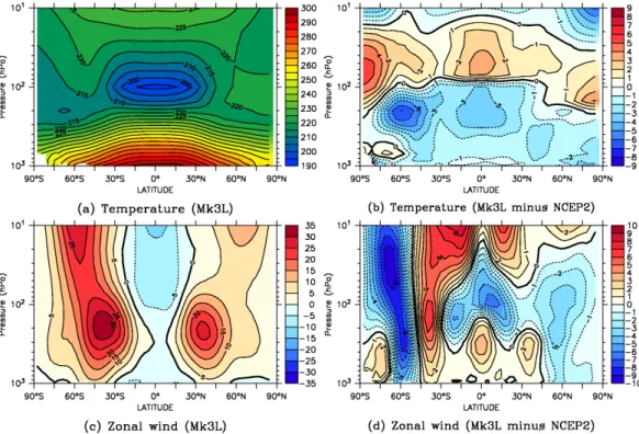
The CSIRO Mk3L climate system model version 1.0 – Part 1: Description and evaluation
Texto
Imagem

Documentos relacionados
Abstract | In light of environmental and territorial policies, this study focuses on the investments in Brazil of Spanish and Portuguese hotel chains, particularly
The Finite Element Method is used to discretize the system and two probabilistic approaches are considered to model the uncertainties: (1) the stiffness of the torsional spring is
The inflow of Atlantic water to the Nordic Seas plays two main roles in the climate system: (1) it transports heat into the Arctic Mediterranean, which affects sea ice and
The surface energy balance is evaluated using SEB observations from three AWSs in the ablation and percolation zone along the K-transect and from those AWSs of the GC-net for
This paper introduces a first time development of a two-way online coupled system from three models of atmosphere, ocean and sea ice (CCLM, TRIMNP and CICE, re- spectively) using
Simulated aerosol size distributions are in reasonable agreement with obser- vations in the marine boundary layer and in the free troposphere, while the model underestimates
First steps towards such a 3D climate-enabled GIS have been made during the execution of the presented project by im- plementing a 3D database that is able to store geometrical
We present regional patterns of dynamic sea level change given by a global-coupled atmosphere–ocean climate model forced by spatially and temporally varying projected ice-melt
