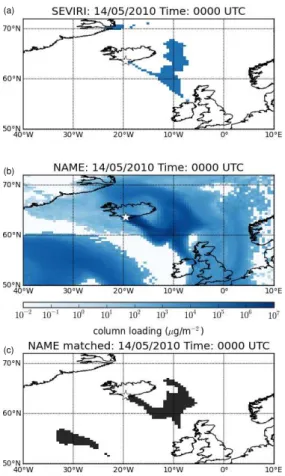
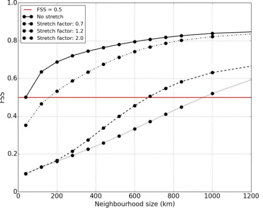
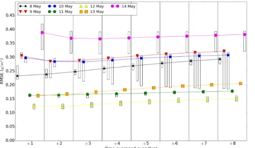
Spatial evaluation of volcanic ash forecasts using satellite observations
Texto
Imagem

Documentos relacionados
Osmanlie de la langue Hongroise [Studies on the History of the 16 th –17 th Centuries Ottoman Turk- ish Language: Elements of Ottoman Turkish in the Hungarian Language].
The probability of attending school four our group of interest in this region increased by 6.5 percentage points after the expansion of the Bolsa Família program in 2007 and
Managers involved residents in the process of creating the new image of the city of Porto: It is clear that the participation of a resident designer in Porto gave a
(1984) analisando povoamentos de Eucalyptus saligna, aos 8 e 9 anos de idade, respectivamente, verificaram que em média 85% da biomassa aérea encontrava- se no fuste (madeira
Using a free software for satellite image analysis, the photointerpretation showed that the NS, NE and NW directions observed on the Pantanal satellite images are the same recorded
Correlation coefficients between the mean columnar SO 2 measured by the Brewers in Europe and provided by the satellite products of OMI and GOME-2 during the volcanic eruptions
Correlation between nucleation mode number concentra- tion and SO 2 /CS proxy calculated using in situ data at Marikana measurement station at the time of the satellite overpass
δ 18 O (in ‰) in water vapour on model level 11, approximately 1 km above the surface, at 00:00 UTC 20 January (a) and in six-hourly accumulated precipitation at 12:00 UTC 19 Jan-
