P4C.1 THE BAURU FLASH FLOOD OF 8 FEBRUARY 2001 AND OPTIONS FOR IMPROVED WARNINGS
Gerhard Held1 and Jorge Luis Gomes2 1 Universidade Estadual Paulista, Bauru S.P., Brazil
2 Centro de Previsão do Tempo e Estudos Climáticos, Cachoeira Paulista, S.P., Brazil
1. INTRODUCTION
In the State of São Paulo, located in the south-east of Brazil, severe convective storms frequently cause local flooding in towns and/or devastation of crops and property due to hail or wind storms (microbursts), resulting in many millions of US Dollar damage annually, loss of lives and leave many persons injured (Gomes et al., 2000; Held et al., 2001). Therefore, it is of prime importance to develop an effective alert system for the occurrence of these severe storms, ranging from a couple of days (based on model outputs) to one to three hours ahead (nowcasting, using radar information) of these events. The Meteorological Research Institute (IPMet) of the University of the State of São Paulo (UNESP), based in the geographic center of the State in the town of Bauru, operates a network of two S-band Doppler radars for continuous precipitation monitoring in the State of São Paulo (Figure 4), which provided the ideal tools for such a pilot study.
The Bauru radar is located at Lat: 22° 21’28” S, Lon: 49°01’ 36” W, 624 m amsl, while the second radar is in Presidente Prudente, 240 km west of Bauru (275° azimuth), at Lat: 22° 10’ 30” S, Lon: 51° 22’ 22” W, 460 m amsl. Both have a 2° beam width and a range of 450 km for surveillance (0° PPI every 30 min), but when operated in volume-scan mode every 15 minutes (or less) it is limited to 240 km, with a resolution of 1 km radially and 1° in azimuth, recording reflectivities and radial velocities. The reflectivity threshold for this study was set at 10 dBZ. Both radars have Sigmet processors and run under the IRIS Operating System, featuring an automatic alert, which is primarily based on the Vertically Integrated Liquid water content (VIL) and reflectivity threshold (the trigger is set to 40 dBZ above 3.5 km with VIL of ≥3 mm over at least 5 km2).
The operational Eta model (Black, 1994) is run by the Center for Weather Forecast and Climatic Studies (CPTEC) twice daily (00 & 12 UTC) for the South American continent and initiated with the NCEP analysis (resolution T62L28; ca 200x200 km). On the boundaries it is updated with the CPTEC Global Model forecasts. The output has a resolution of 40x40 km, for every 6 hours up to 72 hours ahead. The Meso Eta model (Staudenmaier, 1996), running in non-hydrostatic mode, is also initialized with the NCEP analysis, but the boundary conditions are updated with the CPTEC/Eta operational model (resolution 40x40 km). Its domain is 1300x840 km and can be centered over any point. The output resolution is 10x10 km, with variable output
Corresponding author address: Gerhard Held, Instituto de Pesquisas Meteorológicas, UNESP, CX-281, 17001-970 Bauru, S.P., Brazil;
e-mail: [email protected]
intervals up to 72 hours ahead. For this case study, the model domain was centered over Bauru with output every 3 hours.
2. SYNOPTIC SITUATION IN FEBRUARY 2001
The beginning of February 2001 was characterized by synoptic situations typical for summer in the interior of the State of São Paulo. In broad terms, it can be summed up by a high pressure system situated off the coast between the State of São Paulo and southern Brazil and ridging in over the continent, with a weak cold front extending along its northern flank across Rio de Janeiro into Minas Gerais. The other component was a large cyclone initially centered over north-western Argentina from where a tongue of moist air extended across Paraguay, Paraná and the State of São Paulo into Mato Grosso do Sul. An other important fact was the strong confluence of wind in the 700 hPa level over the State of São Paulo, overlaid by an exceptionally strong divergence ≥ 500 hPa. The deep cyclone, which had developed over the southern part of the continent on 6 February had drastically intensified while moving south-eastwards, pushing the anticyclone eastwards off the central part of the continent and towards the ocean. This resulted in extremely strong confluence of moist maritime air near the surface over the State of São Paulo at the 850 hPa level. North-east to south-west orientated divergence over the States of Rio de Janeiro and central São Paulo could already be seen at 700 hPa, resulting in a very strong vertical shear in this region (Held and Nachtigall, 2002).
On three days, relatively isolated and more or less stationary storms developed into very intense cells, accumulating vast amounts of rain and hail above cloud base for periods of about 30 minutes and longer (Held and Nachtigall, 2002). A cyclonic shear, observed in the radial velocity field of the Bauru S-band Doppler radar near ground, probably induced strong updrafts, which supported the accumulated precipitation aloft. Once these updrafts collapsed, all precipitation came down within a short period of time, resulting in parts of Bauru being flooded, due to inadequate drainage capabilities and possibly saturated catchments.
3. RADAR OBSERVATIONS
14:00, thereafter growing in size and intensity, with more and more cells developing and merging into large complexes, especially in the north-north-east to east-south-east sector between 60-200 km in range. At around 18:00, due to new development rapidly progressing from north and north-west within the 50 km range, the town of Bauru (ca 300 000 inhabitants) appeared to be threatened and a general warning for extremely heavy rainfall was issued to the local Civil Defense Authority, solely based on radar observations and automatically generated alerts. Figure 1 shows the 450 km surveillance PPI (EL=0°) at 18:30.
Figure 1. Surveillance PPI (EL=0°, 450 km range) at 18:30 on 8 February 2001.
The first indication of an extremely severe cell just north-west of the catchment, was observed at 18:16, manifested in a dramatic tilt of the echo core, with a significant vertical shear of radial velocities from +13 m.s-1 at cloud base to –11m.s-1 near the echo top (18:31), still accumulating precipitation aloft. At 18:46, a well-pronounced shear in radial velocities (up to –1.8x10⁻³ s-1) could be observed near the ground along a 50 km long, radially-oriented line along the 325° azimuth, persisting for more than 30 min. Figure 2 shows the vast amounts of precipitation still being accumulated above cloud base at 19:01. Heavy rain only began to fall at 19:16 in the catchment, with rainfall rates of up to 200 mm.h-1 for at least 15 minutes, causing flash floods in tributaries, as well as in the main river, which resulted in the loss of five lives through drowning and three due to landslides and collapsing structures, with an estimated material damage of about US $ 1.5 million. Only by 20:01 had the reflectivity over the catchment dropped to ± 45 dBZ (50 mm.h-1). The rain in the inundated area stopped between 20:16 and 20:31. However, other parts of Bauru still received moderate rain until well after 21:00 while the storm complex moved slowly north-westwards.
Further post analysis of the radar data revealed, that if a microburst (MB) warning module would have been available to the radar meteorologist in real-time, a
Figure 2. 8 February 2001, 19:01. Top: PPI with radar reflectivity at EL=1.7°; Bottom: vertical cross section.
more specific warning for the north-west sector could have already been issued to Civil Defense Authorities at 17:01, when the first MB was flagged at <20 km range, followed by frequent warnings in the same region until the flooding event (Held and Nachtigall, 2002).
4. Eta MODEL PREDICTIONS
The operational Regional Eta model (grid resolution of 40 km), initiated with boundary conditions from the global model on 6 February 2001 at 21:00
(07 February, 00:00 UTC), predicted 48 hours ahead virtually no rain within the 240 km range of the Bauru radar for the 6-hour period ending at 21:00, but showed the rain area further north, probably linked to the cold front (Figure 3). However, a run initiated 12 hours later (7 February, 09:00) did predict moderate rainfall (≤10 mm accumulated in 6 hours) in the north-west sector of the radar, but only for the period 21:00 to 09:00 on 9 February, considerably later than observed.
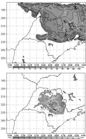
Post analysis runs of the Meso Eta model with a grid resolution of 10 km, centered over Bauru, and also initiated on 6 February 2001, 21:00 (07 February, 00:00 UTC), using boundary conditions from the Eta operational model, predicted the rainfall very well 48 hours ahead, but underestimated the maximum of the 24-hour rain total by about a factor of 2-3 (Figure 4). The model runs initiated 12 hours later (7 February, 09:00) also predicted the rain field, but further out in range. Figure 4 also shows the accumulated radar rainfall (≥1 mm within 240 km of both radars) during the same 24-hour period relative to the model prediction.
Figure 4. 24-hour accumulated rainfall on 8/9 Feb 2001. Top: Contours show model-predicted rainfall; shaded area indicates ≥1 mm rain observed by the Presidente Prudente (PPR) and Bauru (BRU) radars.
Bottom: Observed 24-hour rainfall totals at rain monitoring stations.
Accumulated rainfall within the 450 km range had to be extracted manually from the surveillance PPIs and also confirmed the model-predicted rainfall areas, with the exception of the north-west sector, where the model failed to forecast rain.
Since most of the intense rain occurred within the 240 km range of the Bauru radar, it was decided to only use this radar for a more detailed comparison with the model outputs. The onset of the rain was well predicted when one compares the 6-hour accumulated rainfall maps for the period ending 15:00 (rain only in the north-east and north-north-west sectors of the radar). Even the most intense phase of the storms (15:00 to 21:00; Figure 5) was captured very well regionally, although the model underestimated the local peaks observed by the radar. However, some of the most intense storms responsible for the flooding just north-west of the radar occurred within a narrow region where the model did not predict any rain. After 21:00, the model predicted the decaying stage of the storms too slowly and thus overestimated the areas with rain until 03:00 slightly, also because it did not consider the westward drift.
The Meso Eta Model predicts a large variety of parameters and their post analysis showed, that 36 hours after initialization (at 09:00 LT) the con-vergence of humidity field indicated a well-pronounced, very narrow, south-east to north-west oriented maximum of >15 [(kg/kg)/s]*10e7 (Figure 6) in exactly the region where the severe cells would develop about 9 hours later (Figure 2).
Figure 6. Model-predicted convergence of humidity in [(kg/kg)/s]*10e7 at 850 hPa on 8 Feb. 2001 at 09:00 LT.
Further study of dynamic and thermodynamic parameters predicted for the afternoon (15:00 to 21:00) confirmed this, such as a strong maximum of the K Index centered over Bauru, together with a strong negative maximum of Omega (vertical flux >–1.6 kg.m-2.s-2) at 850 hPa, reaching through the 500 hPa level up to 300 hPa (–1.2 kg.m-2.s-2). Strong divergence at the 300 hPa level was also predicted in the Bauru area, together with a strong westerly jet at 250 hPa over the southern-most part of the domain, where very little or no rain occurred. In the north-east sector of the Bauru radar, where the storms first developed (Figure 1), strongly converging streamlines (10-12 m.s-1) at 200 hPa predicted the inflow of tropical air from the north-west, while at low levels (850 hPa) advection of moist oceanic air was predicted for the morning prior to the storm development, creating favorable conditions. However, it should also be noted, that none of the other maxima of humidity convergence apparent in Figure 6 were supported by any of the dynamic and thermodynamic parameters, thus leaving only the Bauru area for strong development of convection, with a good likelihood for severe storms.
5. CONCLUSION
The severe storms observed on 8 February 2001 by the Bauru radar provided an ideal opportunity to test the forecasting ability of the Meso Eta Model in order to extend the nowcasting range of the radar observations from a couple of hours to about two days.
Based on the findings for this day, the operational Regional Eta model is obviously too coarse to capture the extreme local rainfalls resulting in a flash flood, as
one would expect. However, it appears that the Meso Eta model can predict accumulated precipitation reasonably well up to 48 hours ahead and also provide good estimates of the region where extreme convective development will take place, when considering the various dynamic and thermodynamic predictors. Accumulated areal radar-measured and actually observed rainfall were used for varying periods to verify the model-generated rainfall estimates. The predicted synoptic conditions match well the actual situation described in Section 2. However, it should be emphasized, that this model is currently not running operationally and that for this test all parameters were set to defaults. Thus, based on more case studies, some fine-tuning will still be required, which could lead to improved forecasting capabilities. On the time scale of nowcasting, significant improvements in predicting extreme convective events, potentially causing floods or devastating hail and wind storms, could be achieved, if a microburst detection module was available in real-time to the radar meteorologists, which could permit more specific warnings to be issued up to two hours ahead of the storm event.
6. ACKNOWLEDGEMENTS
Hermes A. G. França is thanked for assisting with the retrieval and pre-processing of the raw radar data, while Ms Simone Cincotto Souto prepared the accumulated radar rainfall data for display in GrADS format.
7. REFERENCES
Black, T. L., 1994: NMC Notes: The new NMC mesoscale Eta model: description and forecast examples. Weather and Forecasting, 9, 256-278. Gomes, A. M., Held, G, Lima, M. A. and Calheiros R.V.,
2000: Estudo da Evolução de Tempestades Severas na Área Central do Estado de São Paulo por Radar Doppler. Proceedings, XI Congresso Bras. de Meteor., SBMET, Rio de Janeiro, 16-20 Outubro 2000, Paper MR00006, p 1921-1929. Held, G., Gomes, A. M. and Nachtigall, L. F., 2001:
Severe Storm Signatures Observed by Doppler Radar in the State of São Paulo, Brazil: From Synoptic Scale to Microburst. Preprints, 30th International Conference on Radar Meteorology, Munich, Germany, 19-24 July 2001, 248-250. Held, G. and Nachtigall, L. F., 2002: Flood-producing
Storms in Bauru during February 2001. Proceedings, XII Congresso Brasileiro de Meteorologia (CD ROM), SBMET, Foz de Iguaçu, 4-9 de agosto de 2002, Paper SP5_35, 3155-3163. Staudenmaier, M. J., 1996: A description of Meso Eta
model. WR-Technical Attachment 96-06.
Color figures and additional information can be found at URL -

![Figure 6. Model-predicted convergence of humidity in [(kg/kg)/s]*10e 7 at 850 hPa on 8 Feb](https://thumb-eu.123doks.com/thumbv2/123dok_br/15834089.138112/4.918.110.443.235.499/figure-model-predicted-convergence-humidity-kg-hpa-feb.webp)
