ACPD
15, 15397–15429, 2015Annual ET retrieved solely from satellites’
VIs for the EM
D. Helman et al.
Title Page
Abstract Introduction
Conclusions References
Tables Figures
◭ ◮
◭ ◮
Back Close
Full Screen / Esc
Printer-friendly Version Interactive Discussion
Discussion
P
a
per
|
Discussion
P
a
per
|
Discussion
P
a
per
|
Discussion
P
a
per
|
Atmos. Chem. Phys. Discuss., 15, 15397–15429, 2015 www.atmos-chem-phys-discuss.net/15/15397/2015/ doi:10.5194/acpd-15-15397-2015
© Author(s) 2015. CC Attribution 3.0 License.
This discussion paper is/has been under review for the journal Atmospheric Chemistry and Physics (ACP). Please refer to the corresponding final paper in ACP if available.
Annual evapotranspiration retrieved
solely from satellites’ vegetation indices
for the Eastern Mediterranean
D. Helman1, I. M. Lensky1, and A. Givati2
1
Department of Geography and Environment, Bar Ilan University, Ramat-Gan, Israel
2
Israeli Hydrological Service, Water Authority, Jerusalem, Israel
Received: 1 March 2015 – Accepted: 12 May 2015 – Published: 8 June 2015
Correspondence to: D. Helman ([email protected])
ACPD
15, 15397–15429, 2015Annual ET retrieved solely from satellites’
VIs for the EM
D. Helman et al.
Title Page
Abstract Introduction
Conclusions References
Tables Figures
◭ ◮
◭ ◮
Back Close
Full Screen / Esc
Printer-friendly Version Interactive Discussion
Discussion
P
a
per
|
Discussion
P
a
per
|
Discussion
P
a
per
|
Discussion
P
a
per
|
Abstract
We present a simple model to retrieve actual evapotranspiration (ET) solely from satel-lites (PaVI-E). The model is based on empirical relationships between vegetation in-dices (NDVI and EVI from MODIS) and total annual ET (ETAnnual) from 16 FLUXNET sites representing a wide range of plant functional types and ETAnnual. The model
5
was applied separately for (a) annual vegetation systems (i.e., croplands and grass-lands) and (b) systems with combined annual and perennial vegetation (i.e., wood-lands, forests, savannah and shrublands). It explained most of the variance in ETAnnual
in those systems (71 % for annuals, and 88 % for combined annuals and perennials systems) while multiple regression and modified Temperature and Greenness models 10
using also land surface temperature did not improve its performance (p >0.1). PaVI-E was used to retrieve ETAnnualat 250 m spatial resolution for the Eastern Mediterranean
from 2000 to 2014. Models’ estimates were highly correlated (R=0.92,p <0.01) with
ETAnnual calculated from water catchments balances along rainfall gradient in the
East-ern Mediterranean. They were also comparable to the coarser resolution ET prod-15
ucts of MSG (LSA-SAF MSG ETa, 3.1 km) and MODIS (MOD16, 1 km) at 148 Eastern Mediterranean basins with correlation coefficients (R) of 0.75 and 0.77 and relative bias of 5.2 and−5.2 %, respectively (p <0.001 for both). The proposed model is expected to contribute to hydrological study in the Eastern Mediterranean assisting in water re-source management, which is one of the most valuable rere-sources of this region. 20
1 Introduction
Actual evapotranspiration (ET) is a primary component of the global water cycle. Its assessment at global and regional scales is essential for forecasting future atmospheric feedback (Jung et al., 2010; Oki and Kanae, 2006; Zemp et al., 2014). Estimating ET at such scales though, is not straightforward and requires the use of models (Chen et al., 25
ACPD
15, 15397–15429, 2015Annual ET retrieved solely from satellites’
VIs for the EM
D. Helman et al.
Title Page
Abstract Introduction
Conclusions References
Tables Figures
◭ ◮
◭ ◮
Back Close
Full Screen / Esc
Printer-friendly Version Interactive Discussion
Discussion
P
a
per
|
Discussion
P
a
per
|
Discussion
P
a
per
|
Discussion
P
a
per
|
using satellite information benefit from a continuous spatio-temporal direct observation (Ma et al., 2014; Shi and Liang, 2014).
Satellite-based ET models are classified into two: (1) empirical, using the relationship between in situ ET and satellites-derived vegetation indices (VIs) (Glenn et al., 2011; Nagler et al., 2012; Tillman et al., 2012) and (2) physical, using surface temperature 5
from satellites to solve energy balance equations (Anderson et al., 2008; Colaizzi et al., 2012). While some models combine the two approaches (Tsarouchi et al., 2014).
Although physical-based models are much more common their performance is com-parable to that of the empirical-based models (Glenn et al., 2010). The accuracy of both approaches is within that of the eddy covariance measurements (70–90 %) used 10
for their calibration or validation (Kalma et al., 2008). Yet, the empirical approach is simpler than the physical-based model and requires less additional information.
The basis for the empirical model is the resource optimisation theory. This theory suggests that plants adjust their foliage density to the environmental capacity to support photosynthetic activity and transpiration (Glenn et al., 2010). Accordingly, changes in 15
vegetation foliage cover (and VIs) will affect ET resulting in high ET–VIs correlations. Then, the empirical equation could be used to retrieve ET in space and time.
This approach is mostly used in vegetation systems with annual cycle of growth and drying where VIs define well the phenological stages (Glenn et al., 2011; Helman and Lensky, 2015; Senay et al., 2011). However, in complex systems comprised of annual 20
(i.e. herbaceous) and perennial (i.e. woody) vegetation the model must be adjusted with additional meteorological data (Helman and Lensky, 2015; Maselli et al., 2014).
The main drawback of the empirical-based approach is that it is limited to a specific site and vegetation type (Glenn et al., 2010; Maselli et al., 2014; Nagler et al., 2012). No common relationship was found between ET and VIs for different sites and climatic 25
conditions.
ACPD
15, 15397–15429, 2015Annual ET retrieved solely from satellites’
VIs for the EM
D. Helman et al.
Title Page
Abstract Introduction
Conclusions References
Tables Figures
◭ ◮
◭ ◮
Back Close
Full Screen / Esc
Printer-friendly Version Interactive Discussion
Discussion
P
a
per
|
Discussion
P
a
per
|
Discussion
P
a
per
|
Discussion
P
a
per
|
and on complex systems comprising annuals and perennials vegetation. Three empiri-cal models were examined: (1) simple regression, (2) multiple regression and (3) mod-ified Temperature and Greenness models with 16 day and mean annual data. We used a performance-simplicity criterion to choose the model to retrieve ET for the Eastern Mediterranean (EM). Estimates were compared with MODIS and MSG ET operational 5
products and evaluated against ET calculated from water catchments balances in the EM.
2 Data
2.1 Evapotranspiration from eddy covariance towers
In situ ET was derived from eddy covariance towers that constitute the international 10
flux towers net (FLUXNET). Two open FLUXNET sources were used to acquire the datasets: the Oak Ridge National Laboratory Distributed Active Archive Centre (avail-able online (http://fluxnet.ornl.gov) from ORNL DAAC, Oak Ridge, Tennessee, USA) and the European fluxes database (http://gaia.agraria.unitus.it/home). Half-hourly level 4 ET data were checked for acceptable quality (Reichstein et al., 2005) and gap-filled 15
using methods described in Reichstein et al. (2005) and Moffat et al. (2007). Then, data were aggregated to 16 days means (mm d−1) and total annual ET (mm yr−1). Only ET data since the time MODIS VIs products are available were used (i.e. since 2000).
2.2 Satellite products
We used 16 day NDVI and EVI at a spatial resolution of 250 m (MOD13Q1) and 8 day 20
ACPD
15, 15397–15429, 2015Annual ET retrieved solely from satellites’
VIs for the EM
D. Helman et al.
Title Page
Abstract Introduction
Conclusions References
Tables Figures
◭ ◮
◭ ◮
Back Close
Full Screen / Esc
Printer-friendly Version Interactive Discussion
Discussion
P
a
per
|
Discussion
P
a
per
|
Discussion
P
a
per
|
Discussion
P
a
per
|
The MODIS 16 day VIs product is a composite of a single day value selected from 16 days period based on a maximum value criterion (Huete et al., 2002). It represents well the vegetation status of the entire 16 day period because of the gradual develop-ment of the vegetation. This enables regressing this MODIS VIs product against 16 day averages of ET. NDVI is defined as (Rouse et al., 1974):
5
NDVI=R0.8−R0.6
R0.8+R0.6
, (1)
and EVI as (Huete et al., 2002):
EVI=2.5× R0.8−R0.6
R0.8+6R0.6−7.5R0.5+1
, (2)
whereR0.8,R0.6andR0.5are the reflectance at near infrared (0.8 µm), red (0.6 µm) and
blue (0.5 µm) bands, respectively. NDVI suffers from asymptotic problems (saturation) 10
over high density of vegetation biomass while EVI is more sensitive in such cases (Huete et al., 2002).
For the model development, time series of NDVI, EVI and LST at each FLUXNET site were obtained from MODIS Land Product Subsets (http://daac.ornl.gov/MODIS/modis. html) (ORNL DAAC, Oak Ridge, Tennessee, USA, last accessed December 2014) 15
for the years when ET data was available since 2000 (see “Period” column in Ta-ble 1). NDVI and EVI time series were smoothed using local weighted scatterplot tech-nique (LOWESS) as in Helman et al. (2014a, b) and Helman and Lensky (2015). For model implementation, tiles h20v05, h21v05, h20v06 and h21v06 of the MOD13Q1 product were downloaded for 2000–2014 using the USGS EarthExplorer tool (http: 20
ACPD
15, 15397–15429, 2015Annual ET retrieved solely from satellites’
VIs for the EM
D. Helman et al.
Title Page
Abstract Introduction
Conclusions References
Tables Figures
◭ ◮
◭ ◮
Back Close
Full Screen / Esc
Printer-friendly Version Interactive Discussion
Discussion
P
a
per
|
Discussion
P
a
per
|
Discussion
P
a
per
|
Discussion
P
a
per
|
3.1 km/30 min and daily for MSG) (Hu et al., 2015). Daily LSA-SAF MSG ETa images were aggregated to one year (365 days for 2011) for North Africa tile (NAfr). The to-tal annual ET MODIS product (MOD16A3) was downloaded for the same tiles of the VIs product. The basins layer map was taken from HydroSHEDS, a mapping product based on high-resolution elevation developed by the Conservation Science Program 5
of World Wildlife Fund (http://hydrosheds.cr.usgs.gov). Only main basins with an area greater than 10 km2were selected (Fig. S1 in the Supplement).
3 Methods
3.1 Sites selection
Perennial and annual vegetation in Mediterranean regions have distinctive phenology 10
contributing differently to the VIs signal (Karnieli, 2003; Lu et al., 2003). Helman and Lensky (2015) suggested that to use VIs for ET assessment vegetation systems com-prising both annual and perennial vegetation (i.e., forests, woodlands, savannah and shrublands, hereafter PA) should be treated separately from those with only annual vegetation (i.e., croplands and grasslands, hereafter AN).
15
They found that annual vegetation in the understory of PA systems might contribute significantly to VIs while having very small contribution to total ecosystem ET (Helman and Lensky, 2015). In some cases this results in an apparent phase shift between ET and VIs (Fig. 1) leading to negative or no correlations. Moreover, AN systems showed one singular ET–VI relationship under wide range of rainfall conditions while 20
significantly differ for similar PA systems under different climatic regimes (Helman and Lensky, 2015).
Therefore, we examined ET–VIs relationships in AN and PA systems separately. FLUXNET sites in AN systems were selected from wide range of climatic regimes. FLUXNET sites in PA systems were selected only from Mediterranean-climate regions. 25
ACPD
15, 15397–15429, 2015Annual ET retrieved solely from satellites’
VIs for the EM
D. Helman et al.
Title Page
Abstract Introduction
Conclusions References
Tables Figures
◭ ◮
◭ ◮
Back Close
Full Screen / Esc
Printer-friendly Version Interactive Discussion
Discussion
P
a
per
|
Discussion
P
a
per
|
Discussion
P
a
per
|
Discussion
P
a
per
|
of satellite and eddy covariance data in the FLUXNET site, (2) missing data less than 30 days yr−1for ET and 15 % for VIs; and (3) homogeneous vegetation cover near the FLUXNET tower within at least the 250 m spatial resolution of MODIS VIs products. The last criterion was manually assured using Google Earth™. These led us to select 16 FLUXNET sites that represent a wide range of plant functional types and annual ET 5
rates (Table 1).
3.2 Empirical ET models using VIs and LST
Three regression models using VIs and/or LST and ET from eddy covariance towers were tested:
1. Simple regressions between VIs and ET or LST and ET using 16 day or annual 10
data.
2. Multiple regressions using VIs and LST as dependent variables with 16 day or annual data.
3. Modified version of the Temperature and Greenness (TG) model proposed by Sims et al. (2008) using LST as a proxy for radiation and reference ET (Maeda 15
et al., 2011) with 16 day data alone.
We used all models with 16 day ET averages and 16 day VIs/LST data but only the first two models with total annual ET and mean annual VIs/LST because the TG model was designed for 16 day data alone (Sims et al., 2008). In AN we used the integral over the VIs growth season (i.e. after subtracting the annual minimum VIs) instead of 20
the original 16 day VIs data (see in Helman et al., 2014a, b). The integral over the VIs growth season was used in the two regression models against total annual ET (Helman and Lensky, 2015). Multiple regression models were applied only with NDVI and LST or EVI and LST, but not with NDVI and EVI because NDVI and EVI were highly correlated (R >0.95,p <0.001).
ACPD
15, 15397–15429, 2015Annual ET retrieved solely from satellites’
VIs for the EM
D. Helman et al.
Title Page
Abstract Introduction
Conclusions References
Tables Figures
◭ ◮
◭ ◮
Back Close
Full Screen / Esc
Printer-friendly Version Interactive Discussion
Discussion
P
a
per
|
Discussion
P
a
per
|
Discussion
P
a
per
|
Discussion
P
a
per
|
The original TG model is based on the correlations between MODIS-EVI and GPP, which are further refined by incorporating LST (Sims et al., 2008):
GPP=a×EVIscaled×LSTscaled, (3)
where EVIscaledis the scaled EVI set to zero at EVI=0.1 (i.e. EVIscaled=EVI−0.1) due
to absence of photosynthetic activity at this value (Sims et al., 2006);ais the slope of 5
the relationship that enables parameterization of the model; and LSTscaled is daytime
LST scaled to 1 at an optimum temperature for leaf photosynthetic response around 30◦C, decreasing towards 0 at lower and higher temperatures as follows (Sims et al., 2008):
LSTscaled=min
LST 30
; (2.5−0.05×LST)
, (4)
10
Note that LSTscaled in Eq. (4) is negative at LST higher than 50◦C. In such case,
LSTscaled is set to 0 assuming no photosynthetic activity at those high temperatures
following a stomata closure (Sims et al., 2008).
Here, we modified the TG model by using ET instead of GPP in Eq. (3):
ET=a×EVIscaled×LSTscaled. (5)
15
The rational is that GPP and ET are correlated through trade-offs between carbon gains and water loss during photosynthesis processes. We used the modified TG model with EVI and NDVI alternatively in Eq. (5).
3.3 Models evaluation
Pearson’s correlation coefficient (R) and mean absolute error (MAE) were used to eval-20
ACPD
15, 15397–15429, 2015Annual ET retrieved solely from satellites’
VIs for the EM
D. Helman et al.
Title Page
Abstract Introduction
Conclusions References
Tables Figures
◭ ◮
◭ ◮
Back Close
Full Screen / Esc
Printer-friendly Version Interactive Discussion
Discussion
P
a
per
|
Discussion
P
a
per
|
Discussion
P
a
per
|
Discussion
P
a
per
|
ttest was conducted to examine statistical differences between the models (p value). The best model was selected using a performance-simplicity criterion, i.e. the model with the highestR (and mean relative error<30 %) with respect to its complexity (num-ber of variables and operations needed) was preferred.
3.4 Land cover map for model implementation
5
ET was assessed for the Eastern Mediterranean using the best models for AN and PA systems separately. To produce the required land cover map, we classified pixels as AN/PA based on their NDVI during the year. Low NDVI during the dry season (<0.25) implies absent or dry vegetation typical for AN systems (Lu et al., 2003). Yet, some PA systems (e.g. open shrublands) also have low NDVI during this period but differ from 10
AN systems by smaller NDVI change (<0.4) during the growth season (Lu et al., 2003; Roderick et al., 1999).
Hence, we classified pixels with minimum NDVI<0.25 as AN only if their NDVI in-creased by more than 0.4 during the growth season. To account for the high NDVI in agricultural fields of the Nile delta, pixels with minimum NDVI smaller or equal to 0.35 15
were also classified as AN only if their NDVI increased by more than 0.35. All remaining pixels were automatically classified as PA (Fig. S2).
Although this classification procedure is a bit coarse, we preferred it upon the MODIS land cover product for two reasons. First, a significant discrepancy was found between MODIS-based land cover product and actual land cover type distribution in the Eastern 20
Mediterranean (Sprintsin et al., 2009a). Second, this procedure produces a mask at the spatial resolution of the model (250 m), while the MODIS-derived land cover product is available at coarser resolution (500 m).
The produced AN/PA land cover map showed the general pattern known for this region (Fig. S2). Moreover, the total AN area estimated for Israel not considering the 25
ACPD
15, 15397–15429, 2015Annual ET retrieved solely from satellites’
VIs for the EM
D. Helman et al.
Title Page
Abstract Introduction
Conclusions References
Tables Figures
◭ ◮
◭ ◮
Back Close
Full Screen / Esc
Printer-friendly Version Interactive Discussion
Discussion
P
a
per
|
Discussion
P
a
per
|
Discussion
P
a
per
|
Discussion
P
a
per
|
3.5 Evapotranspiration calculated from water catchments balances
We evaluated our model with mean annual ET calculated from six water catch-ments balances along gradient rainfall (130–800 mm yr−1) in the Eastern Mediter-ranean (Fig. S3). The calculation followed the classical water balance equation:
ET=P −Q−dS
dt, (6)
5
whereP andQare the total annual precipitation and discharge measured in the catch-ment, and dS/dtis the change in water storage. For timescales of several years, dS/dt
is assumed to be negligible, so the mean annual ET could be simply calculated from
P minus Q (Conradt et al., 2013). Because we used water balances averaged over 14 years (i.e. 2000–2013), this assumption was also valid in our case (Table 2).
10
The water balances approach has some drawbacks like the difficulty to properly es-timate precipitation distribution over the catchment and uncertainties about catchment boundaries (Conradt et al., 2013). However, it is the best existing approach to compare in situ ET with satellite-derived ET at a basin scale.
4 Results and discussion
15
4.1 ET–VIs in systems comprising annual and perennial vegetation
Total annual ET was highly correlated with mean annual NDVI in FLUXNET sites of PA systems with anR ranging from 0.85 to 0.93 (Table 3; Fig. 2). In contrast, 16 day ET averages were only poorly correlated with 16 day NDVI (R=0.17–0.63). The same was for total annual ET and mean annual EVI withR of 0.66–0.94 compared to R of 20
ACPD
15, 15397–15429, 2015Annual ET retrieved solely from satellites’
VIs for the EM
D. Helman et al.
Title Page
Abstract Introduction
Conclusions References
Tables Figures
◭ ◮
◭ ◮
Back Close
Full Screen / Esc
Printer-friendly Version Interactive Discussion
Discussion
P
a
per
|
Discussion
P
a
per
|
Discussion
P
a
per
|
Discussion
P
a
per
|
mean annual NDVI and EVI were significant enough to detect even small interannual changes in ET of 20–40 mm yr−1(e.g. ES-Amo in Fig. 2).
LST was negatively correlated with 16 day and total annual ET in all PA FLUXNET sites. This implies the role of transpiration in attenuating thermal load (Rotem-Mindali et al., 2015). Mean annual LST was highly correlated with total annual ET (|R|>0.84, 5
p <0.05) particularly in sites with low canopy cover (IL-Yat – 30–45 % and ES-LMa – 20–30 %; Casals et al., 2009; Sprintsin et al., 2009b). Those sites had relatively high interannual variability in LST (2–3.5◦C; Fig. 2).
When using all data from PA FLUXNET sites together, correlation coefficients were high as in site-specific annual regressions (Fig. 3). Correlations were high using linear 10
and exponential functions (R=0.94,p <0.05 for both VIs and functions). Mean annual NDVI and EVI explained 71 and 88 % of the variability in total annual ET, which is within the accuracy of the eddy covariance technique for estimating ET (Glenn et al., 2010; Kalma et al., 2008). Annual ET and LST were also correlated through a negative relationship when using all PA together (R=−0.89,p <0.05, Fig. 3).
15
The contribution of annual and perennial vegetation to VIs at the sub pixel level is most difficult to distinguish in PA systems (Karnieli, 2003). In some cases, one of those components might have dominant contribution to VIs but insignificant to the ecosystem flux exchange (Fig. 1). This is probably one of the reasons that VIs could not be used to assess ET at a seasonal timescale (i.e. using 16 day data) in such systems (Helman 20
and Lensky, 2015). However, at interannual timescales (i.e. using the annual mean) re-lationships between ET and VIs were strong and might be used to retrieve total annual ET in PA systems.
4.2 Comparison between empirical VIs-based ET models
In AN, correlation coefficients from simple regressions of annual ET against VIs grow-25
ACPD
15, 15397–15429, 2015Annual ET retrieved solely from satellites’
VIs for the EM
D. Helman et al.
Title Page
Abstract Introduction
Conclusions References
Tables Figures
◭ ◮
◭ ◮
Back Close
Full Screen / Esc
Printer-friendly Version Interactive Discussion
Discussion
P
a
per
|
Discussion
P
a
per
|
Discussion
P
a
per
|
Discussion
P
a
per
|
integrals was higher (R=0.88) than that against EVI integrals (R=0.79). However, mean relative error (i.e. MAE/mean) was much lower for annual correlations (12–16 %) than for 16 day correlations (32–33 %, Table 5). The relatively high R for the 16 day ET–VIs regressions in AN supports the biomass-ET–VIs relationship in those systems described elsewhere (Glenn et al., 2010; Helman and Lensky, 2015).
5
Correlations did not significantly improve (p >0.1) for AN when LST was added in multiple regression models (Table 4 and 5). The R using 16 day data in multiple re-gression models was 0.87 (for LST with NDVI or EVI) compared to an R of 0.86 for simple regression model (for NDVI or EVI). For the annual data,R was 0.89 and 0.79 (for LST with NDVI or EVI) compared to 0.87 and 0.82 (for LST with NDVI or EVI) from 10
the simple regression model.
In PA, correlations using 16 day data substantially improved (p <0.05 for both in-dices) for multiple regression model compared to simple regression model withR of 0.71 and 0.73 (for LST with NDVI or EVI) compared to 0.51 and 0.61 (NDVI and EVI). But,R from simple and multiple regression models using annual data were not statisti-15
cally different (p >0.1). In this case,R from both models was high (R=0.94 and 0.96 for LST with NDVI or EVI,R=0.94 for both ET–NDVI and ET–EVI).
The modified TG model resulted in significantly higherR (p <0.05 for both indices) only for PA and for 16 day data alone (R=0.80 and 0.78 using NDVI or EVI in Eq. 5). However, it was still significantly lower (p <0.05 for both VIs) than simple ET–VIs cor-20
relations when using annual data (Table 4 and Fig. S4b). In AN,R from TG and 16 day ET–VIs were not significantly different (p >0.1, Table 4 and Fig. S4a).
4.3 PaVI-E model
NDVI and EVI were the best explanatory factors of the interannual change in ET at both, AN and PA systems (Table 4). This means that simple ET–VIs regression func-25
ACPD
15, 15397–15429, 2015Annual ET retrieved solely from satellites’
VIs for the EM
D. Helman et al.
Title Page
Abstract Introduction
Conclusions References
Tables Figures
◭ ◮
◭ ◮
Back Close
Full Screen / Esc
Printer-friendly Version Interactive Discussion
Discussion
P
a
per
|
Discussion
P
a
per
|
Discussion
P
a
per
|
Discussion
P
a
per
|
the simple regression function as the best model following the performance-simplicity criterion. The functions obtained from ET–NDVI and ET–EVI regressions were aver-aged for PA:
ETAnnual=[85 exp(3NDVI)+65 exp(6.9EVI)]/2, (7)
and AN systems:. 5
ETAnnual=[187 exp(0.23NDVIGSI)+224 exp(0.26EVIGSI)]/2. (8)
Where ETAnnualis the total annual ET in mm yr− 1
. NDVI and EVI in Eq. (7) are the mean annual NDVI and EVI. NDVIGSI and EVIGSIin Eq. (8) are the integrals over NDVI and EVI growth season, respectively. The exponential function was preferred over the linear one because the latter leads to negative values at NDVI (and EVI) of∼0.1 (a value that 10
usually corresponds to soil background), while in reality ET is still greater than zero due to surface evaporation (Helman and Lensky, 2015).
Finally, we named this model PaVI-E, the Parameterization of Vegetation Indices for ET estimation model. The mean relative error of PaVI-E was 13 and 12 % for AN and PA, respectively. This is within the accuracy of the eddy covariance measurements 15
that were used for calibration and much lower than the reported from complex models (Glenn et al., 2010; Kalma et al., 2008). PaVI-E was used to assess total annual ET at spatial resolution of 250 m for the Eastern Mediterranean after using the land cover map created for AN and PA as a mask (Sect. 3.3 and Fig. S2).
4.4 Model evaluation in the Eastern Mediterranean
20
4.4.1 Comparison with MODIS and MSG ET products
ACPD
15, 15397–15429, 2015Annual ET retrieved solely from satellites’
VIs for the EM
D. Helman et al.
Title Page
Abstract Introduction
Conclusions References
Tables Figures
◭ ◮
◭ ◮
Back Close
Full Screen / Esc
Printer-friendly Version Interactive Discussion
Discussion
P
a
per
|
Discussion
P
a
per
|
Discussion
P
a
per
|
Discussion
P
a
per
|
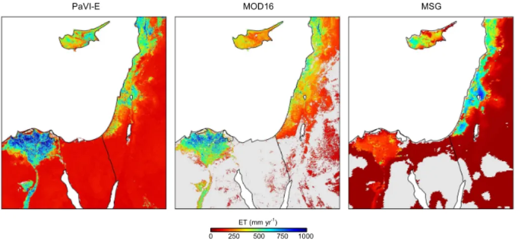
models show a general west to east and south to north ET gradients along the eastern coastline, matching the rainfall gradients of this region (Ziv et al., 2014). Also, all three models show higher ET estimates over agricultural fields in the Nile delta compared to the surrounding desert.
However, some discrepancies also exist. MOD16 estimates were lower along the 5
EM coast compared to PaVI-E and MSG. ET estimates from MSG were relatively high along the eastern coast especially to the east of the Sea of Galilee (mean ET of∼800 mm yr−1). Differences between models were particularly noted over the Nile delta. The average annual ET over the Nile delta for 2011 was 160 mm yr−1from MSG, 530 mm yr−1from MOD16, and 680 mm yr−1from PaVI-E. While MSG estimates seem 10
extremely low for such highly productive area, PaVI-E and MOD16 estimates agreed well with the high ET reported from in situ measurements (Elhag et al., 2011). Besides the advantage of an improved spatial resolution (250 m compared to 1 and 3.1 km of MOD16 and MSG) PaVI-E also has the ability to produce spatially continuous ET com-pared to MSG and MODIS products (Fig. 4).
15
Comparing the three models at a basin scale resulted in good agreement between them (R=0.77 and 0.75 for PaVI-E vs. MOD16 and MSG, respectively,p <0.001 for both; Fig. 5). MOD16 and MSG products had small bias with respect to PaVI-E with a relative bias (i.e. bias/mean) of −5.2 and 5.2 % and slopes of 0.76 and 1.17 for MOD16 and MSG ET products, respectively.
20
The relatively higher/lower MOD16 estimates in xeric/mesic Mediterranean areas (Fig. 5) was already pointed out by Trambauer et al. (2014) that compared this product with several independent ET models. Furthermore, comparison of MOD16 and MSG ET products in Europe showed that correlations with in situ ET (from 15-eddy covari-ance sites) were better for MSG (Hu et al., 2015), and that MOD16 underestimate ET 25
ACPD
15, 15397–15429, 2015Annual ET retrieved solely from satellites’
VIs for the EM
D. Helman et al.
Title Page
Abstract Introduction
Conclusions References
Tables Figures
◭ ◮
◭ ◮
Back Close
Full Screen / Esc
Printer-friendly Version Interactive Discussion
Discussion
P
a
per
|
Discussion
P
a
per
|
Discussion
P
a
per
|
Discussion
P
a
per
|
4.4.2 Evaluation against ET from water balances along rainfall gradient
ET estimates from PaVI-E were evaluated against ET calculated from six water catch-ments along rainfall gradient in the Eastern Mediterranean (EM). PaVI-E estimates were highly correlated with ET from water balances (R=0.92, p <0.01) at six catch-ments along the north–south rainfall gradient in the EM (Fig. 6a). ET from MOD16 and 5
MSG were also significantly correlated with the water balances-derived ET (p <0.05, Fig. S5). All three models had very similar ET estimates in the mountain aquifer catch-ments (MA-N, MA-CS, and MA-S), lower than the calculated from water balances (Fig. 6b). Still, within the accuracy of the models (∼12 %) and gauging/rainfall dis-tribution uncertainties (∼10–15 %, Conradt et al., 2013).
10
As shown in Fig. 4, ET estimates derived from PaVI-E are significantly higher than those from MOD16 and MSG in the dry areas of the EM. This is due to the expo-nential functions used in PaVI-E (Eqs. 7 and 8). It generated a comparable ET to that calculated from water balances at the dry catchment of Mamashit with a slight overes-timation (15 %) of PaVI-E (Fig. 6b). MSG largely underestimated the calculated ET in 15
Mamashit (by more than 85 %) while MOD16 had no data for this area.
5 Conclusions
Three VIs-based ET models using only eddy covariance ET and MODIS vegetation in-dices and land surface temperature data were tested. Vegetation systems comprising mostly annual vegetation (i.e., grasslands and croplands) had strong VIs relationships 20
ACPD
15, 15397–15429, 2015Annual ET retrieved solely from satellites’
VIs for the EM
D. Helman et al.
Title Page
Abstract Introduction
Conclusions References
Tables Figures
◭ ◮
◭ ◮
Back Close
Full Screen / Esc
Printer-friendly Version Interactive Discussion
Discussion
P
a
per
|
Discussion
P
a
per
|
Discussion
P
a
per
|
Discussion
P
a
per
|
and modified TG models using VIs and LST were not significantly better than simple ET–VIs regression models in both vegetation systems (p >0.1).
Following a performance-simplicity criterion we used the simple ET–VIs interannual relationships to retrieve total annual ET for the Eastern Mediterranean. This model named here the parameterized vegetation index for ET estimates model (PaVI-E) had 5
comparable estimates to those from MODIS and MSG ET products in the Eastern Mediterranean. Models’ estimates also agreed well with ET calculated from six water catchments balances along the south–north EM rainfall gradient. The advantage of PaVI-E is in its simplicity and resolution (250 m) compared to the coarser resolutions of MODIS and MSG ET products (1 and 3.1 km, respectively).
10
Improvement in the estimation of ET is essential for water budget calculations and water resource management especially in water limited regions. Here we propose the use of a simple model to retrieve annual ET at 250 m spatial resolution suitable for the Eastern Mediterranean region. We are confident that using PaVI-E will enhance the hydrological study in this region where ET plays a major role in the hydrological cycle. 15
The Supplement related to this article is available online at doi:10.5194/acpd-15-15397-2015-supplement.
Acknowledgements. Authors are grateful to the Rieger Foundation, USA and the Israeli Hydro-logical Service, Water Authority (IWA) for supporting David Helman in his research. Also thanks to Shilo Shifffor his assistance with the LSA-SAF MSG hdf files. This research was supported
20
by the IWA (Grant No. 4500962964). This study used eddy covariance data acquired by the FLUXNET community and in particular by the following networks: AmeriFlux (U.S. Department of Energy, Biological and Environmental Research, Terrestrial Carbon Program), CarboItaly and CarboEuropeIP. MODIS subsets and tiles land products were acquired from the Oak Ridge National Laboratory Distributed Active Archive Centre (ORNL DAAC) and the U.S. Geological
25
ACPD
15, 15397–15429, 2015Annual ET retrieved solely from satellites’
VIs for the EM
D. Helman et al.
Title Page
Abstract Introduction
Conclusions References
Tables Figures
◭ ◮
◭ ◮
Back Close
Full Screen / Esc
Printer-friendly Version Interactive Discussion
Discussion
P
a
per
|
Discussion
P
a
per
|
Discussion
P
a
per
|
Discussion
P
a
per
|
References
Anderson, M. C., Norman, J. M., Kustas, W. P., Houborg, R., Starks, P. J., and Agam, N.: A thermal-based remote sensing technique for routine mapping of land-surface carbon, water and energy fluxes from field to regional scales, Remote Sens. Environ., 112, 4227–4241, doi:10.1016/j.rse.2008.07.009, 2008.
5
Baldocchi, D. D., Xu, L., and Kiang, N.: How plant functional-type, weather, seasonal drought, and soil physical properties alter water and energy fluxes of an oak–grass savanna and an annual grassland, Agr. Forest Meteorol., 123, 13–39, doi:10.1016/j.agrformet.2003.11.006, 2004.
Casals, P., Gimeno, C., Carrara, A., Lopez-Sangil, L., and Sanz, M.: Soil CO2 efflux and
ex-10
tractable organic carbon fractions under simulated precipitation events in a Mediterranean Dehesa, Soil Biol. Biochem., 41, 1915–1922, doi:10.1016/j.soilbio.2009.06.015, 2009. Chamizo, S., Cantón, Y., Miralles, I., and Domingo, F.: Biological soil crust development affects
physicochemical characteristics of soil surface in semiarid ecosystems, Soil Biol. Biochem., 49, 96–105, doi:10.1016/j.soilbio.2012.02.017, 2012.
15
Chen, X., Su, Z., Ma, Y., Liu, S., Yu, Q., and Xu, Z.: Development of a 10-year (2001–2010) 0.1◦ data set of land-surface energy balance for mainland China, Atmos. Chem. Phys., 14, 13097–13117, doi:10.5194/acp-14-13097-2014, 2014.
Colaizzi, P. D., Kustas, W. P., Anderson, M. C., Agam, N., Tolk, J. A., Evett, S. R., Howell, T. A., Gowda, P. H., and O’Shaughnessy, S. A.: Two-source energy balance model estimates of
20
evapotranspiration using component and composite surface temperatures, Adv. Water Re-sour., 50, 134–151, doi:10.1016/j.advwatres.2012.06.004, 2012.
Conradt, T., Wechsung, F., and Bronstert, A.: Three perceptions of the evapotranspiration land-scape: comparing spatial patterns from a distributed hydrological model, remotely sensed surface temperatures, and sub-basin water balances, Hydrol. Earth Syst. Sci., 17, 2947–
25
2966, doi:10.5194/hess-17-2947-2013, 2013.
Craine, J. M., Nippert, J. B., Elmore, A. J., Skibbe, A. M., Hutchinson, S. L., and Brunsell, N. A.: Timing of climate variability and grassland productivity, P. Natl. Acad. Sci. USA, 109, 3401– 3405, 2012.
Elhag, M., Psilovikos, A., Manakos, I., and Perakis, K.: Application of the SEBS water balance
30
ACPD
15, 15397–15429, 2015Annual ET retrieved solely from satellites’
VIs for the EM
D. Helman et al.
Title Page
Abstract Introduction
Conclusions References
Tables Figures
◭ ◮
◭ ◮
Back Close
Full Screen / Esc
Printer-friendly Version Interactive Discussion
Discussion
P
a
per
|
Discussion
P
a
per
|
Discussion
P
a
per
|
Discussion
P
a
per
|
data over the Nile delta, Water Resour. Manag., 25, 2731–2742, doi:10.1007/s11269-011-9835-9, 2011.
Glenn, E., Nagler, P., and Huete, A.: Vegetation index methods for estimating evapotranspiration by remote sensing, Surv. Geophys., 31, 531–555, doi:10.1007/s10712-010-9102-2, 2010. Glenn, E. P., Neale, C. M. U., Hunsaker, D. J., and Nagler, P. L.: Vegetation index-based crop
co-5
efficients to estimate evapotranspiration by remote sensing in agricultural and natural ecosys-tems, Hydrol. Process., 25, 4050–4062, doi:10.1002/hyp.8392, 2011.
Helman, D. and Lensky, I. M.: Empirical relationships between evapotranspiration and MODIS vegetation indices in grasslands, croplands and evergreen forests, Agr. Forest Meteorol., in review, 2015.
10
Helman, D., Lensky, I. M., Mussery, A., and Leu, S.: Rehabilitating degraded drylands by creat-ing woodland islets: assesscreat-ing long-term effects on aboveground productivity and soil fertility, Agr. Forest Meteorol., 195–196, 52–60, doi:10.1016/j.agrformet.2014.05.003, 2014a. Helman, D., Mussery, A., Lensky, I. M., and Leu, S.: Detecting changes in biomass productivity
in a different land management regimes in drylands using satellite-derived vegetation index,
15
Soil Use Manage., 30, 32–39, doi:10.1111/sum.12099, 2014b.
Hollinger, S. E., Bernacchi, C. J., and Meyers, T. P.: Carbon budget of mature no-till ecosys-tem in North Central Region of the United States, Agr. Forest Meteorol., 130, 59–69, doi:10.1016/j.agrformet.2005.01.005, 2005.
Hu, G., Jia, L., and Menenti, M.: Comparison of MOD16 and LSA-SAF MSG
evapo-20
transpiration products over Europe for 2011, Remote Sens. Environ., 156, 510–526, doi:10.1016/j.rse.2014.10.017, 2015.
Huete, A., Didan, K., Miura, T., Rodriguez, E. P., Gao, X., and Ferreira, L. G.: Overview of the radiometric and biophysical performance of the MODIS vegetation indices, Remote Sens. Environ., 83, 195–213, 2002.
25
Jung, M., Reichstein, M., and Bondeau, A.: Towards global empirical upscaling of FLUXNET eddy covariance observations: validation of a model tree ensemble approach using a bio-sphere model, Biogeosciences, 6, 2001–2013, doi:10.5194/bg-6-2001-2009, 2009.
Jung, M., Reichstein, M., Ciais, P., Seneviratne, S. I., Sheffield, J., Goulden, M. L., Bonan, G., Cescatti, A., Chen, J., de Jeu, R., Dolman, A. J., Eugster, W., Gerten, D., Gianelle, D.,
30
ACPD
15, 15397–15429, 2015Annual ET retrieved solely from satellites’
VIs for the EM
D. Helman et al.
Title Page
Abstract Introduction
Conclusions References
Tables Figures
◭ ◮
◭ ◮
Back Close
Full Screen / Esc
Printer-friendly Version Interactive Discussion
Discussion
P
a
per
|
Discussion
P
a
per
|
Discussion
P
a
per
|
Discussion
P
a
per
|
global land evapotranspiration trend due to limited moisture supply, Nature, 467, 951–954, doi:10.1038/nature09396, 2010.
Kalma, J., McVicar, T., and McCabe, M.: Estimating land surface evaporation: a review of methods using remotely sensed surface temperature data, Surv. Geophys., 29, 421–469, doi:10.1007/s10712-008-9037-z, 2008.
5
Karnieli, A.: Natural vegetation phenology assessment by ground spectral measurements in two semi-arid environments, Int. J. Biometeorol., 47, 179–187, doi:10.1007/s00484-003-0169-z, 2003.
Kutsch, W. L., Aubinet, M., Buchmann, N., Smith, P., Osborne, B., Eugster, W., Wattenbach, M., Schrumpf, M., Schulze, E. D., Tomelleri, E., Ceschia, E., Bernhofer, C., Béziat, P., Carrara, A.,
10
Di Tommasi, P., Grünwald, T., Jones, M., Magliulo, V., Marloie, O., Moureaux, C., Olioso, A., Sanz, M. J., Saunders, M., Søgaard, H., and Ziegler, W.: The net biome production of full crop rotations in Europe, Agr. Ecosyst. Environ., 139, 336–345, doi:10.1016/j.agee.2010.07.016, 2010.
Lu, H., Raupach, M. R., McVicar, T. R., and Barrett, D. J.: Decomposition of vegetation cover
15
into woody and herbaceous components using AVHRR NDVI time series, Remote Sens. Environ., 86, 1–18, doi:10.1016/S0034-4257(03)00054-3, 2003.
Ma, Y., Zhu, Z., Zhong, L., Wang, B., Han, C., Wang, Z., Wang, Y., Lu, L., Amatya, P. M., Ma, W., and Hu, Z.: Combining MODIS, AVHRR and in situ data for evapotranspiration estimation over heterogeneous landscape of the Tibetan Plateau, Atmos. Chem. Phys., 14, 1507–1515,
20
doi:10.5194/acp-14-1507-2014, 2014.
Maeda, E. E., Wiberg, D. A., and Pellikka, P. K. E.: Estimating reference evapotranspiration using remote sensing and empirical models in a region with limited ground data availability in Kenya, Appl. Geogr., 31, 251–258, doi:10.1016/j.apgeog.2010.05.011, 2011.
Maselli, F., Papale, D., Chiesi, M., Matteucci, G., Angeli, L., Raschi, A., and Seufert, G.:
Opera-25
tional monitoring of daily evapotranspiration by the combination of MODIS NDVI and ground meteorological data: application and evaluation in Central Italy, Remote Sens. Environ., 152, 279–290, doi:10.1016/j.rse.2014.06.021, 2014.
Maseyk, K. S., Lin, T., Rotenberg, E., Grünzweig, J. M., Schwartz, A., and Yakir, D.: Physiology– phenology interactions in a productive semi-arid pine forest, New Phytol., 178, 603–616,
30
2008.
gap-ACPD
15, 15397–15429, 2015Annual ET retrieved solely from satellites’
VIs for the EM
D. Helman et al.
Title Page
Abstract Introduction
Conclusions References
Tables Figures
◭ ◮
◭ ◮
Back Close
Full Screen / Esc
Printer-friendly Version Interactive Discussion
Discussion
P
a
per
|
Discussion
P
a
per
|
Discussion
P
a
per
|
Discussion
P
a
per
|
filling techniques for eddy covariance net carbon fluxes, Agr. Forest Meteorol., 147, 209–232, 2007.
Nagler, P. L., Brown, T., Hultine, K. R., van Riper III, C., Bean, D. W., Dennison, P. E., Mur-ray, R. S., and Glenn, E. P.: Regional scale impacts of Tamarix leaf beetles (Diorhabda car-inulata) on the water availability of western U. S. rivers as determined by multi-scale remote
5
sensing methods, Remote Sens. Environ., 118, 227–240, doi:10.1016/j.rse.2011.11.011, 2012.
Oki, T. and Kanae, S.: Global hydrological cycles and world water resources, Science, 313, 1068–1072, 2006.
Reichstein, M., Falge, E., Baldocchi, D., Papale, D., Aubinet, M., Berbigier, P., Bernhofer, C.,
10
Buchmann, N., Gilmanov, T., Granier, A., Grünwald, T., Havránková, K., Ilvesniemi, H., Janous, D., Knohl, A., Laurila, T., Lohila, A., Loustau, D., Matteucci, G., Meyers, T., Migli-etta, F., Ourcival, J.-M., Pumpanen, J., Rambal, S., Rotenberg, E., Sanz, M., Tenhunen, J., Seufert, G., Vaccari, F., Vesala, T., Yakir, D., and Valentini, R.: On the separation of net ecosystem exchange into assimilation and ecosystem respiration: review and improved
algo-15
rithm, Glob. Change Biol., 11, 1424–1439, doi:10.1111/j.1365-2486.2005.001002.x, 2005. Reichstein, M., Ciais, P., Papale, D., Valentini, R., Running, S., Viovy, N., Cramer, W.,
Granier, A., Ogee, J., Allard, V., Aubinet, M., Bernhofer, C., Buchmann, N., Carrara, A., Grunwald, T., Heimann, M., Heinesch, B., Knohl, A., Kutsch, W., Loustau, D., Manca, G., Matteucci, G., Miglietta, F., Ourcival, J. M., Pilegaard, K., Pumpanen, J., Rambal, S.,
20
Schaphoff, S., Seufert, G., Soussana, J.-F., Sanz, M.-J., Vesala, T., and Zhao, M.: Reduc-tion of ecosystem productivity and respiraReduc-tion during the European summer 2003 climate anomaly: a joint flux tower, remote sensing and modelling analysis, Glob. Change Biol., 13, 634–651, doi:10.1111/j.1365-2486.2006.01224.x, 2007.
Roderick, M. L., Noble, I. R., and Cridland, S. W.: Estimating woody and herbaceous
veg-25
etation cover from time series satellite observations, Global Ecol. Biogeogr., 8, 501–508, doi:10.1046/j.1365-2699.1999.00153.x, 1999.
Rotem-Mindali, O., Michael, Y., Helman, D., and Lensky, I. M.: The role of local land-use on the urban heat island effect of Tel Aviv as assessed from satellite remote sensing, Appl. Geogr., 56, 145–153, doi:10.1016/j.apgeog.2014.11.023, 2015.
30
ACPD
15, 15397–15429, 2015Annual ET retrieved solely from satellites’
VIs for the EM
D. Helman et al.
Title Page
Abstract Introduction
Conclusions References
Tables Figures
◭ ◮
◭ ◮
Back Close
Full Screen / Esc
Printer-friendly Version Interactive Discussion
Discussion
P
a
per
|
Discussion
P
a
per
|
Discussion
P
a
per
|
Discussion
P
a
per
|
Scott, R. L., Hamerlynck, E. P., Jenerette, G. D., Moran, M. S., and Barron-Gafford, G. A.: Carbon dioxide exchange in a semidesert grassland through drought-induced vegetation change, J. Geophys. Res., 115, G03026, doi:10.1029/2010JG001348, 2010.
Senay, G. B., Leake, S., Nagler, P. L., Artan, G., Dickinson, J., Cordova, J. T., and Glenn, E. P.: Estimating basin scale evapotranspiration (ET) by water balance and remote sensing
meth-5
ods, Hydrol. Process., 25, 4037–4049, doi:10.1002/hyp.8379, 2011.
Shi, Q. and Liang, S.: Surface-sensible and latent heat fluxes over the Tibetan Plateau from ground measurements, reanalysis, and satellite data, Atmos. Chem. Phys., 14, 5659–5677, doi:10.5194/acp-14-5659-2014, 2014.
Sims, D. A., Rahman, A. F., Cordova, V. D., El-Masri, B. Z., Baldocchi, D. D., Flanagan, L. B.,
10
Goldstein, A. H., Hollinger, D. Y., Misson, L., Monson, R. K., Oechel, W. C., Schmid, H. P., Wofsy, S. C., and Xu, L.: On the use of MODIS EVI to assess gross primary productivity of North American ecosystems, J. Geophys. Res., 111, G04015, doi:10.1029/2006JG000162, 2006.
Sims, D. A., Rahman, A. F., Cordova, V. D., El-Masri, B. Z., Baldocchi, D. D.,
Bol-15
stad, P. V., Flanagan, L. B., Goldstein, A. H., Hollinger, D. Y., Misson, L., Monson, R. K., Oechel, W. C., Schmid, H. P., Wofsy, S. C., and Xu, L.: A new model of gross primary productivity for North American ecosystems based solely on the enhanced vegetation in-dex and land surface temperature from MODIS, Remote Sens. Environ., 112, 1633–1646, doi:10.1016/j.rse.2007.08.004, 2008.
20
Skiba, U., Drewer, J., Tang, Y. S., van Dijk, N., Helfter, C., Nemitz, E., Famulari, D., Cape, J. N., Jones, S. K., Twigg, M., Pihlatie, M., Vesala, T., Larsen, K. S., Carter, M. S., Ambus, P., Ibrom, A., Beier, C., Hensen, A., Frumau, A., Erisman, J. W., Brüggemann, N., Gasche, R., Butterbach-Bahl, K., Neftel, A., Spirig, C., Horvath, L., Freibauer, A., Cellier, P., Lav-ille, P., Loubet, B., Magliulo, E., Bertolini, T., Seufert, G., Andersson, M., Manca, G.,
25
Laurila, T., Aurela, M., Lohila, A., Zechmeister-Boltenstern, S., Kitzler, B., Schaufler, G., Siemens, J., Kindler, R., Flechard, C., and Sutton, M. A.: Biosphere–atmosphere exchange of reactive nitrogen and greenhouse gases at the NitroEurope core flux measurement sites: measurement strategy and first data sets, Agr. Ecosyst. Environ., 133, 139–149, doi:10.1016/j.agee.2009.05.018, 2009.
30
dry-ACPD
15, 15397–15429, 2015Annual ET retrieved solely from satellites’
VIs for the EM
D. Helman et al.
Title Page
Abstract Introduction
Conclusions References
Tables Figures
◭ ◮
◭ ◮
Back Close
Full Screen / Esc
Printer-friendly Version Interactive Discussion
Discussion
P
a
per
|
Discussion
P
a
per
|
Discussion
P
a
per
|
Discussion
P
a
per
|
land planted forest, Int. J. Remote Sens., 30, 5061–5069, doi:10.1080/01431160903032885, 2009a.
Sprintsin, M., Karnieli, A., Sprintsin, S., Cohen, S., and Berliner, P.: Relationships between stand density and canopy structure in a dryland forest as estimated by ground-based measurements and multi-spectral spaceborne images, J. Arid Environ., 73, 955–962,
5
doi:10.1016/j.jaridenv.2009.04.011, 2009b.
Suyker, A. E. and Verma, S. B.: Interannual water vapor and energy exchange in an irrigated maize-based agroecosystem, Agr. Forest Meteorol., 148, 417–427, doi:10.1016/j.agrformet.2007.10.005, 2008.
Tillman, F. D., Callegary, J. B., Nagler, P. L., and Glenn, E. P.: A simple method for estimating
10
basin-scale groundwater discharge by vegetation in the basin and range province of Arizona using remote sensing information and geographic information systems, J. Arid Environ., 82, 44–52, doi:10.1016/j.jaridenv.2012.02.010, 2012.
Trambauer, P., Dutra, E., Maskey, S., Werner, M., Pappenberger, F., van Beek, L. P. H., and Uhlenbrook, S.: Comparison of different evaporation estimates over the African continent,
15
Hydrol. Earth Syst. Sci., 18, 193–212, doi:10.5194/hess-18-193-2014, 2014.
Tsarouchi, G. M., Buytaert, W., and Mijic, A.: Coupling a land-surface model with a crop growth model to improve ET flux estimations in the Upper Ganges basin, India, Hydrol. Earth Syst. Sci., 18, 4223–4238, doi:10.5194/hess-18-4223-2014, 2014.
Wilson, T. B. and Meyers, T. P.: Determining vegetation indices from solar and
20
photosynthetically active radiation fluxes, Agr. Forest Meteorol., 144, 160–179,
doi:10.1016/j.agrformet.2007.04.001, 2007.
Zemp, D. C., Schleussner, C.-F., Barbosa, H. M. J., van der Ent, R. J., Donges, J. F., Heinke, J., Sampaio, G., and Rammig, A.: On the importance of cascading moisture recycling in South America, Atmos. Chem. Phys., 14, 13337–13359, doi:10.5194/acp-14-13337-2014, 2014.
25
ACPD
15, 15397–15429, 2015Annual ET retrieved solely from satellites’
VIs for the EM
D. Helman et al.
Title Page
Abstract Introduction
Conclusions References
Tables Figures
◭ ◮
◭ ◮
Back Close
Full Screen / Esc
Printer-friendly Version Interactive Discussion
Discussion
P
a
per
|
Discussion
P
a
per
|
Discussion
P
a
per
|
Discussion
P
a
per
|
Table 1.Description of the 16 selected FLUXNET sites. Horizontal line divides between the six FLUXNET sites in PA systems (Up) and the ten FLUXNET sites in AN systems (Bottom). Plant functional types (PFT) include CSH: closed shrublands, WDL: woodland, SAV: savan-nah, ENF: evergreen needle-leaved forest, WSA: woody savansavan-nah, CRO: croplands, and GRA: grasslands. Mean annual precipitation (P) is in mm yr−1 for the years in which ET data was used (Period).
Site ID Lat Lon PFT Main species P Period Reference
ES-Amo 36.83 −2.25 OSH Dwarf shrubs 200 2009–2011 Chamizo et al. (2012) IL-Yat 31.35 35.05 WDL Pinus halepensis 300 2003–2009 Maseyk et al. (2008) ES-LMa 39.94 −5.77 SAV Quercus ilex 660 2004–2009 Casals et al. (2009) ES-ES 39.35 −0.32 ENF Pinus halepensis 580 2001–2006 Reichstein et al. (2007) FR-Lbr 44.72 −0.77 WSA Pinus pinaster 825 2004–2008 Reichstein et al. (2007) US-Blo 38.90 −120.63 ENF Pinus ponderosa 1350 2001–2006 Sims et al. (2006)
ACPD
15, 15397–15429, 2015Annual ET retrieved solely from satellites’
VIs for the EM
D. Helman et al.
Title Page
Abstract Introduction
Conclusions References
Tables Figures
◭ ◮
◭ ◮
Back Close
Full Screen / Esc
Printer-friendly Version Interactive Discussion
Discussion
P
a
per
|
Discussion
P
a
per
|
Discussion
P
a
per
|
Discussion
P
a
per
|
Table 2.Water balances from six catchments along the north to south rainfall gradient in the Eastern Mediterranean (Fig. S3). Catchments area is in 103ha. Precipitation (P), discharge (Q) and calculated ET asP−Q, are all in mm yr−1. Fluxes were averaged over the years 2000–2013.
Name Area P Q ET
Kziv 13 799 284 515
HaShofet 1.2 654 183 471
MA-N 59 615 193 422
MA-CS 93 592 202 390
MA-S 28 619 257 362
ACPD
15, 15397–15429, 2015Annual ET retrieved solely from satellites’
VIs for the EM
D. Helman et al.
Title Page
Abstract Introduction
Conclusions References
Tables Figures
◭ ◮
◭ ◮
Back Close
Full Screen / Esc
Printer-friendly Version Interactive Discussion
Discussion
P
a
per
|
Discussion
P
a
per
|
Discussion
P
a
per
|
Discussion
P
a
per
|
Table 3.Correlations coefficients (R) of 16 day ET averages and 16 day MODIS-derived NDVI, EVI and daytime LST (LST,◦C); and of total annual ET and mean annual NDVI, EVI and LST in the 6 FLUXNET sites of PA systems (perennials and annuals vegetation systems, i.e. forests, woodlands, savannah and shrublands).
NDVI EVI LST
Site ID 16 day Annual 16 day Annual 16 day Annual
ES-Amo 0.63 0.89 0.62 0.71 −0.51 −0.33
IL-Yat 0.62 0.88 0.70 0.89 −0.36 −0.84
ES-LMa 0.17 0.93 0.28 0.80 −0.22 −0.93
ES-ES 0.41 0.91 0.30 0.94 −0.62 −0.32
FR-Lbr 0.36 0.85 0.68 0.93 −0.65 −0.63
ACPD
15, 15397–15429, 2015Annual ET retrieved solely from satellites’
VIs for the EM
D. Helman et al.
Title Page
Abstract Introduction
Conclusions References
Tables Figures
◭ ◮
◭ ◮
Back Close
Full Screen / Esc
Printer-friendly Version Interactive Discussion
Discussion
P
a
per
|
Discussion
P
a
per
|
Discussion
P
a
per
|
Discussion
P
a
per
|
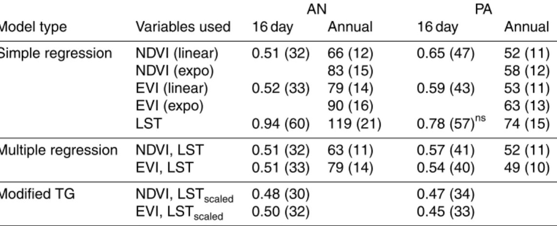
Table 4. Correlations coefficients (R) of three VIs-based ET models using MODIS-derived
NDVI, EVI and daytime LST (LST, ◦C). Results are for models using 16 day/annual data in
AN (annual vegetation systems, i.e. croplands and grasslands), and PA (perennials and annu-als vegetation systems, i.e. forests, savannah and shrublands) systems. AllR were significant atp <0.05 except for the 16 day ET–LST simple regression in PA. Mean annual NDVI and EVI were regressed against total annual ET using linear and exponential functions.
AN PA
Model type Variables used 16 day Annual 16 day Annual
Simple regression NDVI (linear) 0.86 0.88 0.51 0.94
NDVI (expo) 0.87 0.94
EVI (linear) 0.86 0.79 0.61 0.95
EVI (expo) 0.82 0.94
LST −0.42 −0.64 0.00ns −0.89
Multiple regression NDVI, LST 0.87 0.89 0.71 0.94
EVI, LST 0.87 0.79 0.73 0.96
Modified TG NDVI, LSTscaled 0.87 0.78
ACPD
15, 15397–15429, 2015Annual ET retrieved solely from satellites’
VIs for the EM
D. Helman et al.
Title Page
Abstract Introduction
Conclusions References
Tables Figures
◭ ◮
◭ ◮
Back Close
Full Screen / Esc
Printer-friendly Version Interactive Discussion
Discussion
P
a
per
|
Discussion
P
a
per
|
Discussion
P
a
per
|
Discussion
P
a
per
|
Table 5.The mean absolute error (MAE) for Table 4. The 16 day MAE is in mm d−1, while annual MAE is in mm yr−1. In parenthesis is the mean relative error (i.e. MAE/mean) in %.
AN PA
Model type Variables used 16 day Annual 16 day Annual
Simple regression NDVI (linear) 0.51 (32) 66 (12) 0.65 (47) 52 (11)
NDVI (expo) 83 (15) 58 (12)
EVI (linear) 0.52 (33) 79 (14) 0.59 (43) 53 (11)
EVI (expo) 90 (16) 63 (13)
LST 0.94 (60) 119 (21) 0.78 (57)ns 74 (15)
Multiple regression NDVI, LST 0.51 (32) 63 (11) 0.57 (41) 52 (11)
EVI, LST 0.51 (33) 79 (14) 0.54 (40) 49 (10)
Modified TG NDVI, LSTscaled 0.48 (30) 0.47 (34)
ACPD
15, 15397–15429, 2015Annual ET retrieved solely from satellites’
VIs for the EM
D. Helman et al.
Title Page
Abstract Introduction
Conclusions References
Tables Figures
◭ ◮
◭ ◮
Back Close
Full Screen / Esc
Printer-friendly Version Interactive Discussion
Discussion
P
a
per
|
Discussion
P
a
per
|
Discussion
P
a
per
|
Discussion
P
a
per
|
0.0 0.1 0.2 0.3 0.4 0.5 0.6 0.7 0.8
0 1 2 3 4 5
ET
NDVI
Month
ET
(
m
m
d
-1)
N
D
VI
1 4 7 10 1 4 7 10 1 4 7 10 1 4 7 10 1
Corn and soybeans cropland (US-Bo1)
0.45 0.50 0.55 0.60 0.65 0.70 0.75
ET
NDVI
Month
NDVI
Evergreen coniferous forest (ES-ES)
4
3
2
1
0
ET
(
m
m
d
-1)
1 4 7 10 1 4 7 10 1 4 7 10 1 4 7 10 1 4
ACPD
15, 15397–15429, 2015Annual ET retrieved solely from satellites’
VIs for the EM
D. Helman et al.
Title Page Abstract Introduction Conclusions References Tables Figures ◭ ◮ ◭ ◮ Back Close
Full Screen / Esc
Printer-friendly Version Interactive Discussion Discussion P a per | Discussion P a per | Discussion P a per | Discussion P a per |
y = 2,576x - 158
R = 0.94
0.24 0.28 0.32
y = 1,605x - 382
R = 0.91
0.54 0.58 0.62 0.66
y = -74x + 1,958
R = -0.32
15 17 19
LST (°C)
ET ( m m y r -1)
y = 610x + 102
R = 0.71
0 200 400 600 800 1000
0.1 0.14 0.18
EVI
y = 413x + 89
R = 0.89
0 200 400 600 800 1000
0.2 0.24 0.28 0.32
NDVI
y = 1,918x + 12
R = 0.66
0.28 0.32 0.36
y = 2,873x - 1,301
R = 0.92
0.62 0.66 0.7 0.74
y = -77x + 2,059
R = -0.59
15 17 19
y = 2,403x - 257
R = 0.89
0.16 0.2 0.24
y = 1,360x - 276
R = 0.88
0.3 0.34 0.38 0.42
y = -61x + 2,020
R = -0.84
26 28 30
y = 3,119x - 364
R = 0.80
0.24 0.28 0.32
y = 2,051x - 501
R = 0.93
0.44 0.48 0.52 0.56
y = -57x + 1,954
R = -0.93
23 25 27
y = -7x + 405
R = -0.33
0 200 400 600 800 1000
26 28 30
y = 6,158x - 1,461
R = 0.93
0.3 0.34 0.38
y = 3,396x - 1,647
R = 0.85
0.6 0.64 0.68 0.72
y = -120x + 2,791
R = -0.63
15 17 19
ES-Amo IL-Yat ES-LMa ES-ES FR-Lbr US-Blo
ACPD
15, 15397–15429, 2015Annual ET retrieved solely from satellites’
VIs for the EM
D. Helman et al.
Title Page
Abstract Introduction
Conclusions References
Tables Figures
◭ ◮
◭ ◮
Back Close
Full Screen / Esc
Printer-friendly Version Interactive Discussion
Discussion
P
a
per
|
Discussion
P
a
per
|
Discussion
P
a
per
|
Discussion
P
a
per
|
y = 65.31e6.91x
R = 0.94
0 200 400 600 800 1000
0.1 0.2 0.3 0.4
EVI
y = -35x + 1,283
R = -0.89
0 200 400 600 800 1000
10 15 20 25 30 35
LSTday (°C)
y = 84.94e3.12x
R = 0.94
0 200 400 600 800 1000
0.1 0.3 0.5 0.7 0.9
ES-Amo IL-Yat ES-LMa ES-ES FR-Lbr US-Blo
NDVI
ET
(
m
m
y
r
-1)
ACPD
15, 15397–15429, 2015Annual ET retrieved solely from satellites’
VIs for the EM
D. Helman et al.
Title Page
Abstract Introduction
Conclusions References
Tables Figures
◭ ◮
◭ ◮
Back Close
Full Screen / Esc
Printer-friendly Version Interactive Discussion
Discussion
P
a
per
|
Discussion
P
a
per
|
Discussion
P
a
per
|
Discussion
P
a
per
|
0 250 500 750 1000 ET (mm yr-1
)
PaVI-E MOD16 MSG
ACPD
15, 15397–15429, 2015Annual ET retrieved solely from satellites’
VIs for the EM
D. Helman et al.
Title Page
Abstract Introduction
Conclusions References
Tables Figures
◭ ◮
◭ ◮
Back Close
Full Screen / Esc
Printer-friendly Version Interactive Discussion
Discussion
P
a
per
|
Discussion
P
a
per
|
Discussion
P
a
per
|
Discussion
P
a
per
|
MOD16 a = 0.76 b = 68 R = 0.77 bias = -5.2%
MSG a = 1.17 b = 41 R = 0.75 bias = 5.2%
0 150 300 450 600 750
0
150
300
450
600
750
MOD
16
/
MSG
(mm
y
r
-1
)
PaVI-E (mm yr
-1)
ACPD
15, 15397–15429, 2015Annual ET retrieved solely from satellites’
VIs for the EM
D. Helman et al.
Title Page
Abstract Introduction
Conclusions References
Tables Figures
◭ ◮
◭ ◮
Back Close
Full Screen / Esc
Printer-friendly Version Interactive Discussion
Discussion
P
a
per
|
Discussion
P
a
per
|
Discussion
P
a
per
|
Discussion
P
a
per
|
y = 1.01x + 60.66
R = 0.92
0 100 200 300 400 500 600
0 100 200 300 400 500 600
ET
b
a
s
ins
ETPaVI-E
ET
W
a
te
r
b
a
la
n
ce
(m
m
y
r
-1)
ETPaVI-E (mm yr-1) Kziv Hashofet
MA-N MA-CS
MA-S
Mamashit
0 150 300 450 600
Kziv HaShofet MA-N MA-CS MA-S Mamashit Water balances PaVI-E MOD16 MSG
ET
(mm yr
-1)
a
b
Figure 6. (a) Scatter plot of the mean total annual ET (2000–2013) retrieved from PaVI-E and calculated from water balances at six water catchments along the EM north–south rainfall
gradient (Fig. S3).(b)Comparison between mean annual ET estimates from PaVI-E, MOD16,