2016 | Lavras | Editora UFLA | www.editora.ufla.br | www.scielo.br/cagro
http://dx.doi.org/10.1590/S1413-70542016000100003
L
and suitability for final waste disposal with emphasis on septic
systems installation in southern Minas Gerais, Brazil
Aptidão das terras para a destinação final de resíduos com destaquepara a instalação de fossas sépticas no sul de Minas Gerais, Brasil
Jeani Moreira de Oliveira1*, Sérgio Henrique Godinho Silva1, Michele Duarte de Menezes2, Nestor Kämpf3, Nilton Curi2
1Universidade Federal de Lavras/UFLA, Lavras, MG, Brasil
2Universidade Federal de Lavras/UFLA, Departamento de Ciência do Solo/DCS, Lavras, MG, Brasil 3Universidade Federal do Rio Grande do Sul/UFRS, Departamento de Solos, Porto Alegre, RS, Brasil
*Corresponding author: jeanimoreira@yahoo.com.br Received in june 26, 2015 and approved in september 21, 2015
ABSTRACT
Environmental pollution is a problem that has been noted due to changes in the environment, affecting natural resources. Regarding the soil, it may offer great potential for waste disposal. Thus, this study aims to propose criteria for evaluating local suitability for waste disposal, according to soil and terrain attributes for southern Minas Gerais State, and to apply those criteria to define the most appropriate locations for installation of septic systems in a pilot watershed. Literature and the authors’ experience were used to propose the more important criteria regarding the suitability of sites for waste disposal. The set of attributes taken into account was grouped into four suitability classes: Adequate, Regular, Restricted and Inadequate. The defined criteria and considered limiting were: soil depth, texture, textural gradient, structure, natural drainage, water infiltration, type of surface horizon, water table depth, depth of perched water table, distance from water bodies, relief, stoniness, rockiness and risk of flooding. From these, soil depth, natural drainage, water table depth, relief and distance from water bodies were adopted for the installation of septic systems. From the total area of the watershed, 5.29% fit in the Adequate suitability class. The Regular, Restricted, and Inadequate sites accounted for, respectively, 19.72%, 41.99% and 33% of the wathershed. Factors such as soil and terrain attributes provide a basis for defining more appropriate places for waste disposal. Future work should involve the refinement of these propositions, since there are rare studies in this research line in Brazil.
Index terms: Environmental pollution; watershed; pedology.
RESUMO
A poluição ambiental é um grande problema que tem sido notado em decorrência das alterações que ocorrem no ambiente, afetando os recursos naturais. Em relação ao solo, este oferece grande potencial para a destinação final de resíduos. Nesse sentido, objetivou-se, neste trabalho, propor critérios para avaliar a aptidão de locais para a destinação final de resíduos, de acordo com atributos do solo e do terreno, para o sul do Estado de Minas Gerais, e aplicar esses critérios para definir os locais mais apropriados para a instalação de sistemas de fossas sépticas, seguidas de vala de infiltração, em uma sub-bacia hidrográfica piloto. Foram utilizados dados da literatura e a experiência dos autores para a proposição de critérios mais importantes no tocante à aptidão dos locais para a destinação final de resíduos. O conjunto de atributos considerados foi agrupado em quatro classes de aptidão: Adequada, Regular, Restrita e Inadequada. Os critérios definidos e considerados limitantes foram: profundidade do solo, textura, gradiente textural, estrutura, drenagem natural, infiltração de água, tipo de horizonte superficial, profundidade do lençol freático, profundidade do lençol suspenso, distância do curso hídrico, relevo, pedregosidade, rochosidade e risco de inundação. Destes, foram adotados a profundidade do solo, drenagem natural, profundidade do lençol freático, relevo e distância do curso hídrico para a instalação de fossas sépticas. Da área total da sub-bacia, 5,29% se enquadraram na classe de aptidão Adequada. Os locais de aptidão Regular, Restrita e Inadequada totalizaram respectivamente 19,72%, 41,99% e 33% da área da sub-bacia. Fatores como atributos do solo e do terreno dão subsídios para a definição de locais mais propensos à destinação final de resíduos. Trabalhos futuros nessa linha de pesquisa deveriam envolver o refinamento dessas proposições, uma vez que há raros estudos dessa natureza no Brasil.
Termos para indexação: Poluição ambiental; sub-bacia hidrográfica; pedologia.
INTRODUCTION
Environmental pollution is a major problem that has been noted due to changes occurring in the environment,
factors can trigger positive or negative consequences in the others. In relation to the soil, in addition to its importance for food production, it offers great potential as a means of disposal or recycling wastes due to its capacity to promote
the modification of organic and inorganic compounds
by means of chemical reactions, physical or biological
processes. Furthermore, it functions as a filter, decreasing
the residue contamination and preventing many pollutants to get in contact with groundwater.
Soil pollution can be understood as the presence of substances that negatively alter its quality, and may be the cause of public health problems resulting from the indiscriminate disposal of liquid or solid waste on soil, which can cause contamination of the water table and increase the speed of the contamination front. The domestic and industrial wastes are the main responsible for pollution of hydric bodies, especially for the Brazilian medium and large cities. According to Von Sperling (1996), the ecosystem of a soil body prior to waste disposal is usually in a balanced stage, thus, the release of in natura domestic sewage and wastewater may cause proliferation of pathogenic microorganisms not only to humans, but also to local fauna and pets. The release of untreated domestic wastewater is a problem that affects both urban and rural areas. In the latter, sanitation is almost inexistent in most Brazilian regions. A way to minimize this type of problem is the installation of septic tanks followed
by drain field systems.
According to Instituto Brasileiro de Geografia e
Estatística-IBGE (2012), in Brazil only 5.2% of the rural properties have sewage connected to the sewage network and 28.3% contain septic systems (connected or not connected to the network). Furthermore, inappropriate solutions are commonly adopted, including rudimentary septic systems and other alternatives, such as disposal of waste water directly from the house plumbing on the soil surface, and direct disposal of residues on water courses, that can be found in 45.3% and 7.7% of those properties, respectively, although this scenary is relatively better than the observed in 13.6% of them, which do not adopt any solution at all. On the other hand, in urban areas 65.5% of the properties have access to sewage network. Septic systems have the function to separate and transform the solid matter contained in the waste water, while the drain
field is installed for depuration and final disposal of sewage
in the subsurface soil, containing distribution piping
and filtration means therein. It is recommended that the
installed system distributes relatively small amounts of
effluent in a non-concentrated form to avoid clogging of the soil and the poor purification of the effluent.
For Bouma (1979), an acceptable performance of any treatment and disposal systems for domestic
liquid waste implies on the liquid infiltration into the
soil followed by its transformation during percolation, so that it does not contaminate the surface and subsurface water. In this context, the factors that offer great risk to the environment and human health are resulted from the movement of components deposited in the septic tank, causing contamination of surface and subsurface waters. Therefore, septic tanks can be an alternative to improve the disposal of waste in the countryside (mostly), improving sanitation and protecting the water table. However, it is necessary to consider the soil classes (and their properties) of the available areas in order to better allocate septic tanks, since different soils tend to present variable suitability to receive residues without damaging the environment.
In this sense, the aims of this study are to propose criteria
for evaluating local suitability for the final disposal of waste,
according to soil and terrain attributes, for southern Minas Gerais State, and to apply those criteria for the installation of
septic tanks followed by drain fields in a pilot watershed. We
focused on the importance of soil as a receiver and absorber
of effluents, also taking into account the topographic variables,
therefore engineering aspects for the construction of this type of system was not contemplated herein (Associação Brasileira de Normas Técnicas-Abnt, 1993).
MATERIAL AND METHODS
For the definition of the most appropriate places for
waste disposal in southern Minas Gerais region, criteria that represent attributes of the soil and terrain features were considered limiting to this purpose, being selected based on the literature and on the authors’ experience. These factors were interpreted to allow an overall rating of resistance of these locales against environmental impacts caused by the disposal of waste, since some types of impacts may
require the use of specific criteria and further evaluation.
The soil and the terrain features accounted for assessing the land suitability for disposal of waste were grouped in four suitability classes, represented by the terms Adequate, Regular, Restricted and Inadequate. The Adequate class combines the best conditions for the disposal of waste, while the others show, respectively, increasing
restrictions in this regard. A land is classified as Regular,
Restricted or Inadequate when it presents at least one limiting factor with regard to the most appropriate condition.
It was developed a guide table of the suitability
In this context, the most limiting factor is considered as the one that determines the suitability class.
As a case study, based on the guide table, soil properties and terrain features considered relevant for the
definition of more suitable locales for installation of septic tanks and drain fields were selected in order to promote
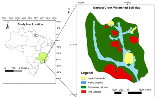
an efficient absorption and purification of effluents. These factors were applied to Marcela Creek watershed, located in Nazareno county, state of Minas Gerais, Brazil (Figure 1), which has great environmental importance and supplies water for the hydroelectric power plant of Itutinga/Camargos, with altitudes ranging from 960 to 1060 meters, covering 485.71 ha.
The soils occurring in the study area (Motta et al.
2001) according to the Brazilian Soil Classification System
(Empresa Brasileira de Pesquisa Agropecuária-Embrapa, 2013) (Figure 1) are: Dystrophic Red-Yellow Latosol (RYL) with moderate A horizon, very clayey texture, covering 325.23 ha, corresponding to 66.96% of the total area of the sub-basin; Dystrophic Red Latosol (RL) with moderate A horizon, very clayey texture, occupying 63.87 ha (13.15%); Tb Haplic Cambisol (HC), moderate A horizon, very clayey texture, which has an area of 21.28 ha (4.38%); and Dystrophic Haplic Gleysol (HG) with moderate A horizon, very clayey texture, occupying 75.33 ha, or 15.51% of the area. Based on the soil map (Motta et al., 2001), topographic information and the authors’ experience, it was generated a map of the suitability of each location for installing septic systems (Figure 2),
using ArcGIS 10.1 (ESRI) software, in order to identify the sites and quantify the geographical expression of the most suitable or less suitable areas for such installation. A digital elevation model (DEM) with spatial resolution of 10 m derived from contour lines at a scale of 1:50,000 (IBGE) was employed to create the slope gradient map, which was used as a source of topographic information for assessing the suitability of each local on the study area.
RESULTS AND DISCUSSION
Sustainability classes for final waste disposal
The basis and the interpretation of factors presented below were essential to direct the suitability of sites for the disposal of waste Kämpf et al. (2008):
• Soil depth: influences on soil volume available
for absorption and attenuation effects. Silva et al. (2010)
found an efficient degradation of contaminants in deeper
soil layers due to the increased amount of clay in depth. Bitton (1994) noted that in layers deeper than 3 m in the
soil profile, fecal coliforms present in wastewater cannot
survive, probably due to the lack of organic material, which has fundamental importance for their survival.
• Texture: the clay fraction is essential to the sorption, retention and buffering of impacting materials (Streck et al., 2008).
• Mineralogy: Latosols and Nitosols, depending on the predominance of kaolinite or Fe and Al oxides
(Resende et al., 2011), are prioritized for conditioning greater soil physical stability (easier management of the
soil, improved trafficability etc.). However, Vertisols, with
a predominance of smectite, are considered very limiting, mainly due to their shrink and swell properties that depend on the moisture content, making the management
and trafficability very difficult, while the Argisols and
Cambisols occupy an intermediate position in this context. • Textural gradient: is characterized by a sandier surface horizon, with considerable clay accumulation in the subsurface horizon. This increment of clay in depth can be abrupt, when it occurs within a short vertical distance
on the soil profile, or gradual, when it is more subtle. This
fact implies on the reduction of soil permeability in depth and can contribute to the formation of perched water table, allowing for the lateral movement of solutions and solid particles, and making the soil susceptible to erosion (Streck et al., 2008; Costa et al., 2009).
• Structure: influences on the aeration, water
storage, infiltration and soil erodibility (Companhia de
Saneamento do Paraná, 1999; Streck et al., 2008; Pinto et al., 2015). According to Ferreira, Fernandes and Curi (1999), knowing the soil structure may help to understand its permeability and hence the ease that liquids move in
the soil profile.
• Infiltration and natural drainage: provide indicatives
on the permeability of the soil and the possibility of contaminating the water table. According to Pote et al. (2001), there may be contamination of groundwater when
the infiltration rate in the soil is high. For that, one should
consider that the other factors are similar.
• Type of surface horizon: the thickness of the surface horizon is directly related to soil volume with higher levels of organic matter in the profile, which
contribute to adsorb the effluent. Greater thickness tends
to increase the adsorption capacity and diminishes the
contamination risk of the deepest layers of the profile and
groundwater.
• Depth of the water table: it involves the growing risk of groundwater contamination (Streck et al., 2008) as this distance decreases in relation to the soil surface.
• Perched water table: in order to prevent contamination of subsurface waters, areas with shallow groundwater or groundwater above the surface should not be used for the disposal of waste due to the high risk of contamination.
• Distance from water bodies: one should avoid the
final disposal of waste in the vicinity of water bodies to
minimize the risk of contamination. According to Gomes
and Martins (2003), areas that are subject to flooding are
inappropriate for waste disposal, due to the possibility of contaminating the water courses by liquid generated in grounding systems.
• Relief: The local relief corresponds to the conformation of the ground surface, with variable
slopes, such as flat (0-3% slope), gently undulated
(3-8%), undulated (8-20%), strongly undulated (20-45%), mountainous (45-75%) and cliff (> 75%) (Santos et al., 2013). In general, a steeper slope increases the risk of soil erosion and the movement of the applied waste towards the water bodies (Companhia de Saneamento do Paraná, 1999).
Figure 2: Scheme representing a septic system, which was the basis for defining the most appropriate soil and
• Rockiness and stoniness: the presence of boulders and/or rock outcrops can restrict the installation of sanitation systems and increase the lateral runoff of the deposited liquid waste.
• Flood risk: represents the risk of contamination by transport of pollutants to waterways.
From the main parameters, the criteria for defining
the suitability of each site to the disposal of general waste are presented in Table 1. The occurrence of at least one
attribute in less suitable classes is sufficient to reduce the
suitability of the location.
Suitability classes for septic systems installation
From the attributes shown in Table 1, the following ones were selected for the installation of septic systems: soil depth, natural drainage, water table depth, relief and distance from the water bodies (Table 2). The latter was altered to suit the ABNT (1993) standard and, thus, distances greater or equal to 15 m were considered Adequate, whereas lesser than 15 m of distance are
Inadequate. However, these distances may be used only after approval by the responsible environmental agency.
In the Adequate suitability class, mainly Latosols, Nitosols and Argisols occur (Streck et al., 2008). In the Regular suitability class mostly medium texture Latosols and Argisols occur. In the Restricted suitability class, Quartzarenic Neosols (excessively drained) and soils with imperfect drainage are predominant. Cambisols, in general, are included into the classes of Regular or Restricted suitability. In the Inadequate class, mainly Litholic Neosols (shallow soils) and soils with drainage problems (Gleysols and Histosols) are included. It is noteworthy to highlight that the soil classes here
exemplified may have their suitability changed due to
relief conditions. Furthermore, it is known that, within the same relief class, there are locales more suitable for septic systems installation than others. For instance, within the undulated relief class (8-20% slope), places with 9% slope would be more appropriate than those with 19% slope. For this reason, it is important to
Table 1: Guide table of the suitability classes for final waste disposal.
Attribute Suitability classes
Adequate Regular Restricted Inadequate
Soil depth (cm) >150 >=100 to 150 >=50 to <100 < 50
Texture Clayey (>35% of clay) Medium (15 to 35% of clay) Sandy (< 15% of clay) Sandy (< 15% of clay)
Textural gradient Without or gradual
With gradient, if
abrupt in depth > 100
cm
With gradient, if
abrupt in depth < 100 cm
With gradient, if
abrupt in depth < 50 cm
Natural drainage Well or moderately drained accentuatedly Strongly or drained
Imperfectly
or excessively
drained
Poorly or very poorly drained
Water table depth
(cm) Absent or > 150 Absent or from 100 to 150 < 100 Superficial
Perched water
table Absent Absent Present Present
Distance from the
water bodies1 (m) >200 >200 <200 <200
Relief
(slope %) (0 - 3)Flat Gently undulated(3 - 8) Undulated(8 -20) Strongly undulated or steeper (> 20)
Stoniness (%) moderately stony (<3 )Not stony to Stony (3 to 15) Very stony (15 a 50) Extremely stony (>50)
Rockiness (%) Not rocky (< 2) Slightly rocky(2 to 10) Moderately rocky (10 to 25) Rocky to extremely rocky (> 25 )
Flood risk Null Null Rare Occasional to frequent
perform an evaluation of land in the field at a more
detailed scale than the proposed guidance attributes and values presented in Table 2, including engineering aspects if applicable.
This developed methodology was applied to the Marcela Creek watershed, considering the soil (Motta et al., 2001) and relief information. In relation to soil properties (Table 3), in general these did not offer great limitations on the installation of septic systems for most of the study area, because there is a predominance of deep, well-drained soils, besides having water table located deeper than 150 cm, as recommended by ABNT (1997). Also, these soils do not contain stones, which
could difficult the installation of septic systems, and they
present very clayey texture and a moderate A horizon,
which contributes to higher retention and purification of effluents disposed in both surface and subsurface soil. An
exception to these conditions are the Gleysols, which have strong limitations due to their occurrence in lower places on the landscape, close to the water bodies, and hence presenting higher water table. Thus, terrain attributes, such as relief and distance from the water bodies were more relevant with regard to limitations on the installation of the sanitation system proposed for the study area, since they are more variable even within the same soil class (Figure 3).
Attribute Suitability classes for installation of septic systems
Adequate Regular Restricted Inadequate
Soil depth (cm) >150 >=100 to 150 >= 50 to <100 < 50
Natural drainage Well or moderately
drained
Strongly or accentuatedly
drained
Imperfectly
or excessively
drained
Poorly or very poorly drained
Water table depth
(cm)
Absent or > 150
under the septic system
Absent or from 100 to 150 under the
septic system
< 100 under the
septic system Superficial
Distance from
water bodies1 (m) >=15 >=15 >=15 <15
Relief (slope %) Flat (0 - 3) Gently undulated (3 - 8) Undulated (8 - 20) Strongly undulated or steeper (> 20)
Table 2: Soil properties and terrain characteristics considered relevant to allow for the installation of septic systems to promote efficient absorption and purification of effluents (Adapted from Kämpf et al. (2008) and Soil Survey Manual (1993)).
1 In agreement with ABNT (1993).
Table 3: Properties of the soil classes found in Marcela Creek watershed 1.
Property Soil Class
HC RYL RL HG
Soil depth (cm) 155 240 200 120
Texture (clay %) Very clayey (> 60) Very clayey (> 60) Very clayey(> 60) Clayey(50)
Stoniness Not stony Not stony Not stony Not stony
Parent material
Product from the alteration of pelitic rocks interspersed with
quartzous material
Product from the alteration of
pelitic rocks
Product from the alteration of pelitic
rocks
Quaternary sediments
Natural drainage
Type of surface horizon
Well drained Moderate A
Well drained Moderate A
Accentuatedly drained Moderate A
Poorly drained Moderate A
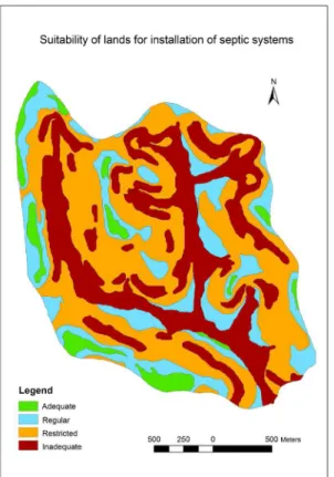
Figure 4 illustrates the spatial distribution of suitability classes for determining the most likely places
to receive septic tanks and drain fields.
From the total area of the watershed, 5.29% were grouped as Adequate suitability, being, therefore, the
Figure 3: Distribution of slope in the Marcela Creed watershed related to soil classes.
Figure 4: Suitability of lands for the installation of septic tanks and drain fields in Marcela Creek Watershed.
bodies greater than 15 m. The Restricted and Inadequate suitability sites make up, respectively, 41.99% and 33% of the study area. These are sites that may have limitations related to drainage, ranging from imperfect to very poor, location in undulated or steeper relief, or even situated lesser than 15 m distant from the water bodies.
In the areas where Cambisols (HC) occur (4.4% of
the watershed), 0.11, 1.14, 1.61 and 1.52 ha were confined
into the Adequate, Regular, Restricted and Inadequate suitability classes, respectively (Table 4). Except for
the areas classified as Adequate, such restrictions may be justified because these soils occur in relief ranging
from gently undulated to strongly undulated (Table 5), increasing the risk of both soil and waste movement towards the water bodies and hence reducing its suitability to the installation of septic systems. The Red-Yellow Latosols (RYL) and the Red Latosols (RL), despite of being deep, they are present mainly in undulated areas, which results in lesser suitability than the ones on gentler topography. Nevertheless, they are soils that have the highest relative area with Adequate suitability for installation of septic systems, with 11.9% of RL areas and 5.4% of the areas of RYL, while HC have only 2.5% of their areas in that suitability class, and Gleysols (HG) are inadequate for this purpose.
Soil class Suitability Area (ha) Area (%)
HC
Adequate 0.54 0.11
Regular 5.54 1.14
Restricted 7.8 1.61 Inadequate 7.4 1.52
HG Inadequate 75.33 15.5
RYL
Adequate 17.53 3.61
Regular 74.47 15.3
Restricted 168.19 34.6 Inadequate 65.04 13.4
RL
Adequate 7.63 1.57
Regular 15.77 3.25 Restricted 27.96 5.76
Inadequate 12.51 2.57
Total 485.71 100
Table 4: Area of the soil classes according to their suitability for installation of septic systems.
The listed factors, both general for disposal of
general waste (Table 1) and specific (Table 2) for the
installation of septic systems, respectively, have only guiding character and do not replace the need for a local
evaluation of land resistance to the impact of specific
activities, including engineering aspects if applicable. Also, the authors do not know works involving this research line for southern Minas Gerais.
CONCLUSIONS
The proposed attributes and their values for determination of land suitability for waste disposal have the goal of helping and supporting decision makers about
the most appropriate places for that, although more specific observations, adjustments and refinements are always
encouraged.
In the studied pilot watershed, relief, proximity to water bodies, and natural soil drainage were the most
limiting attributes for classification of land suitability for the installation of septic tanks and drain fields, because the
majority of its soils, per se, contain adequate properties for such task.
Soil class Relief phase Area (ha) Area (%)
HC
Flat 1.49 0.31
Gently undulated 5.91 1.22
Undulated 8.06 1.66 Strongly
undulated 5.82 1.20
HG Flat 75.33 15.5
Flat 20.43 4.21
RYL Gently undulated 77.54 15.96 Undulated 168.57 34.71
Strongly
undulated 58.69 12.08
RL
Flat 7.46 1.54
Gently undulated 15.94 3.28 Undulated 27.96 5.76
Strongly
undulated 12.51 2.57
Total 485.71 100
ACNKNOWLEDGEMENTS
The authors thank CNPq, CAPES and FAPEMIG
for providing financial support for the development of
this work.
REFERENCES
ABNT - Associação Brasileira de Normas Técnicas. NBR 13969: Tanques sépticos - unidades de tratamento complementar e disposição final dos efluentes líquidos - projeto, construção e operação. Rio de Janeiro: ABNT, 1997. 60p.
ABNT - Associação Brasileira de Normas Técnicas. NBR 7229:
Projeto, construção e operação de sistemas de tanques
sépticos: procedimentos. Rio de Janeiro: ABNT, 1993. 15p. BITTON, G. Wastewater microbiology. 3 ed. New York: John
Wiley & Sons, 2005. 768p.
BOUMA, J. Subfarce applications of sewage effluente. In : BEATTY. M. T. et al. (ed). Planning the uses and managementof land. Madison, ASA-CSSA-SSSA. 1979. p.665-703.
COSTA, A. M. et al. Avaliação do risco de anoxia para o cultivo do eucalipto no Rio Grande do Sul utilizando-se levantamento de
solos. Scientia Forestalis, 37:367-375, 2009.
COMPANHIA DE SANEAMENTO DO PARANÁ. Programa de pesquisa em saneamento básico. Uso e manejo do lodo de esgoto na agricultura. Curitiba: SANEPAR/PROSAB-FINEP, 1999. 98p.
EMPRESA BRASILEIRA DE PESQUISA AGROPECUÁRIA-EMBRAPA. Centro Nacional de Pesquisa de Solos. Sistema Brasileiro de Classificação de Solos. 3. ed. Rio de Janeiro, 2013. 353p.
FERREIRA, M. M.; FERNANDES, B.; CURI, N. Influência da
mineralogia da fração argila nas propriedades físicas de
Latossolos da regiãoSudeste do Brasil. Revista Brasileira
de Ciência do Solo, 23:515-524, 1999.
GOMES, L. P.; MARTINS, F. B. Projeto, implantação e operação de aterros sustentáveis de resíduos sólidos urbanos para municípios de pequeno porte. In: CASTILHOS JUNIOR,
A. B. Projeto, implantação e operação de aterros
sustentáveis de resíduos sólidos urbanos para
municípios de pequeno porte. Florianópolis:Editora Rima Artes e Textos, 2003. 288p.
INSTITUTO BRASILEIRO DE GEOGRAFIA E ESTATÍSTICA -IBGE -. PNAD: Pesquisa Nacional de Amostragem Domiciliar, ISSN 0101-6822. Rio de Janeiro, 32:1-134, 2012.
KÄMPF, N. et al. Metodologia para classificação de solos quanto à resistência a impactos ambientais decorrentes da disposição final de resíduos. FEPAM em Revista, 2:11-17, 2008.
MOTTA, P. E. F. et al. Levantamento pedológico detalhado, erosão dos solos, uso atual e aptidão agrícola das terras de microbacia piloto na região sob influência do reservatório da hidrelétrica de Itutinga-MG. Lavras: UFLA/CEMIG, 2001. 51p.
PINTO, L. C. et al. Role of inceptisols in the hydrology of mountainous catchments in Southeastern Brazil. Journal of Hydrologic Engineering, 2015 Available at: <http://ascelibrary.org/doi/abs/10.1061/(ASCE)HE.1943-5584.0001275>. Accessed on: August, 21, 2015.
POTE, D. H. et al. Water-quality effects of infiltration rate and manure application rate for soils receiving swine manure.
Journal of Soil and Water Conservation, 56:32-37, 2001. RESENDE, M. et al. Mineralogia de Solos Brasileiros -Interpretações e Aplicações. 2. ed. Lavras: EDITORA UFLA, 2011. 201p.
SANTOS, R. D. dos et al. Manual de descrição e coleta de solo no campo. 6. ed. Viçosa: SBCS, 2013. 100p.
SILVA, F. A. et al. Influência da temperatura, umidade e
profundidade do solo na persistência do diurom. Química
Nova, 33:1457-1463, 2010.
SOIL SURVEY STAFF. Soil Survey Manual. USDA Handbook No. 18. Washington: US Government Printing Office, 1993. 437p.
STRECK, E. V. et al. Solos do Rio Grande do Sul. 2. ed. Porto Alegre: EMATER/RS-ASCAR, 2008. 222p.