Alice Marques Pereira Mestranda
Universidade Estadual Paulista Júlio de Mesquita - UNESP – Programa de Pós-Graduação em Geociências e Meio Ambiente, Instituto de Geociências e Ciências Exatas (IGCE) - Rio Claro – São Paulo - Brazil
César Augusto Moreira Professor Assistente Doutor
Universidade Estadual Paulista Júlio de Mesquita - UNESP – Departamento de Geologia Aplicada (DGA), Instituto de Geociências e Ciências Exatas (IGCE) - Rio Claro – São Paulo - Brazil
José Ricardo Melges Bortolin Professor Horista
Centro Universitário Herminio Ometto – UNIARARAS – Araras – São Paulo - Brazil [email protected]
Syngra Machado Lopes Doutoranda
Universidade Estadual Paulista Júlio de Mesquita - UNESP – Programa de Pós-Graduação em Geociências e Meio Ambiente, Instituto de Geociências e Ciências Exatas
(IGCE) - Rio Claro – São Paulo - Brazil [email protected]
Antonio José Ranalli Nardy Professor Assistente Doutor
Universidade Estadual Paulista Júlio de Mesquita - UNESP – Departamento de Petrologia e Metalogenia (DPM),
Instituto de Geociências e Ciências Exatas (IGCE) - Rio Claro – São Paulo - Brazil [email protected]
Magnetometric exploration
in intrusive basic with evidence
of gold in northern region of
the Camaquã Sedimentary
Basin (RS)
Abstract
This study involved magnetometric exploration in the region of São Sepé (RS), southern Brazil, to evaluate the potential for gold mineralization in a gabbro using evidence previously obtained from the geochemical exploration of stream sediments. The gabbro named Santa Catarina is intruded in the Metamorphic Complex Vaca-caí, a metassedimentary sequence where several gold deposits were recognized. In this study, nine lines of land magnetometry were performed with 1.200m in length each, a total of 10.800m and 720 reading stations. The results suggest the presence of ilonian mineralization in fractures, some of which are subject to weathering action, releasing and transporting gold by water action and depositing it along the stream sediments downstream from the gabbro. The analytical signal map outlines areas of high mag-netic susceptibility within its boundaries, coinciding with structural lineaments in the NS and EW directions, associated with the last of the four stages of regional deforma-tion, possibly responsible for both fracturing and opening of spaces in the gabbro, as by remobilization of sulide and gold recognizably described in several gold deposits within the Vacacaí Metamorphic Complex.
Keywords: mineral exploration; gabbro; fracture; analytic signal.
Resumo
Esse estudo consiste na aquisição de dados magnetométricos na região de São Sepé (RS), sul do Brasil, com o propósito de avaliar o potencial de minerali-zação aurífera de um gabro, a partir de indícios obtidos em prospecção geoquími-ca de sedimentos de corrente prévios. O gabro denominado Santa Catarina está intrudido no Complexo Metamórico Vacacaí, uma sequência metassedimentar ,onde foram reconhecidas diversas jazidas de ouro. Nesse estudo, foram realizadas nove linhas de magnetometria terrestre, com 1.200 m de comprimento cada, num total de 10.800 m e 720 estações de leitura. Os resultados sugerem a presença de mineralizações ilonianas em fraturas, algumas das quais sujeitas à ação intem-périca, com liberação e transporte de ouro por ação luvial e deposição junto a sedimentos de corrente a jusante do gabro. O mapa de sinal analítico descreve as áreas de alta susceptibilidade magnética dentro de seus limites, coincidentes com lineamentos estruturais nas direções NE e E-W, associadas a
à última das quatro fases de deformação regional, possivelmente responsável, tanto por fraturamento e abertura de espaços no gabro, quanto pela remobilização de sulfeto e ouro reconhecidamente descritos em diversas jazidas de ouro no âmbi-to do Complexo Metamórico Vacacaí.
Palavras-chave: exploração mineral; gabro; fratura; sinal analítico.
Geosciences
Geociências
1. Introduction
Mineral exploration is of funda-mental importance for the discovery of new deposits, as well as for detailing or revaluating known deposits. This is achieved through a series of techniques for direct and indirect geological investi-gations, planned in a manner to provide increased detailing of the mineralized geological conditions.
Searches using indirect tools such as geophysical investigations make in-depth investigations possible by measuring in-trinsic physical properties and geological materials such as mineral accumulations. Such methods are represented by applied geophysics, whose data can be acquired through aerial surveys and ground cam-paigns, besides the use of remote sensing
and aerial photos (Telford et al, 1990;
Moon et al, 2006).
Among the several geophysical methods, magnetometry shows good results, referring to geological structural mapping, as well as associations between magnetic ields and possible mineraliza-tion. This method can provide indications of mineral accumulations such as sulides and oxides, quite contrasting with the main minerals that form rocks, such as silicates.
Research in potentially mineralized targets of copper, gold, iron oxides, for example, enable detailing by magnetom-etry, subsequently conirmed by sampling and geochemistry. Studies such as those of Sharma (1986), Doyle, (1990); Fallon &
Backo, (1994); Vella, (1994); Maas et al.,
(2003); Nabighian, et al, (2005); Jackson,
(2005); Rodrigues et al., (2006); Oliveira
(2007), Batista et al., (2006); Batista, et al., (2008); Sultan et al., (2009), Súarez et al., (2012) and Gonçalves et al., (2013)
reinforce the effectiveness of this method in mineral exploration.
This paper presents and discusses the application of data from a magne-tometry survey method developed for assessing the potential for gold mineral-ization in a gabbro, justiied by evidence of the gold mineralization obtained in geochemical prospection of stream sedi-ment, collected in the drainage originated from the gabbro 1km downstream of the study area center.
Location and geology of the study area
The study area is represented by gabbro Santa Catarina, is located in the south of Brazil, in the city of São Sepé city, State of Rio Grande do Sul, about 270 km distant from from Porto Alegre city, and accessed by the BR 290 highway between the towns of South Cacapava do Sul and Vila Nova do Sul.
Filonian gold mines are represent-ed in the region by ores characterizrepresent-ed by associations of quartz veins with gold and small amounts of iron oxides, pyrite and chalcopyrite. The veins pres-ent NE and NW directions and are preferably embedded in rock types of
the Vacacaí Metamorphic Complex, subconcordant or discordant to the general structure (Figure 2).
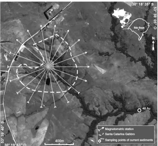
A geochemical study of the col-lected stream sediment sample taken ap-proximately 1 km downstream from the center of Santa Catarina gabbro drainage recorded 48 pints of gold, well above the average 45 gold particles characteristic for the region, besides arsenopyrite and pyrite together with heavy minerals (CPRM , 2000).
The investigated area is located in southern Brazil in the central sector of the State of Rio Grande do Sul, in the
unit denominated Sulriograndense Shield, represented by metamorphic, igneous and sedimentary rocks, with Archean and Proterozoic ages, compartmentalized into blocks and bordered by large regional faulting in the NE-SW directions (Paim
et al. 2000).
The Basic/Ultrabasic Stratiform Complex covers the area of study and comprises layered rocks, such as perido-tites, gabbros and anorthosite. The gabbro Santa Catarina was originally described by Rodrigues et al. (1982). The gabbro is
in contact by fault with rocks of the Va-cacaí Metamorphic Complex (Figure 1).
Figure 1
Geology of study area (Adapted from CPRM, 2000).
The Vacacaí Metamorphic Com-plex comprises an association of
vol-canic, volcaniclastic and sedimentary rocks, metamorphosed in the green
schist, along with magnesium sequenc-es. This intrusive event is attributed to the Upper Proterozoic (CPRM, 1995).
When characterized by a multi-phase tectonic evolution in this unit, it is possible to discern four phases of deformation. The first three phases (D1, D2 and D3), generated folds with a tendency to axial coaxiality in the NE/ SW direction and are related to com-pressive stress directed to SE, where D1 and D2 relect a tangential movement , while D3 is characterized as associated to a transcurrence phase. Meanwhile, the fourth phase of deformation (D4)
generated folds with axial orientation NW/SE, resulting from a large reorien-tation of the global stress system in the Sulriograndense Shield (CPRM, 1995).
The deformation phase D1 was responsible for the folding and trans-position of the layers. The deformation phase D2 resulted in a signiicant mass transport from northwest to southeast, evidenced by tectonic imbrications fea-turing structural arrangement between the various metamorphic associations in the region. The deformation phase D3 is responsible for the coaxial refolding and generation of folds of normal type,
with moderate slope axes, now to NNE, then to SW. In general, these are open folds often of monoclinal trend with the hinge line inclined in from to NW. The folds generated in the D4 deformation phase are characterized by presenting axes with guidance close to orthogo-nality with respect to the structures established in the previous phases. They feature soft folds, of decimetric dimen-sions, represented by metamorphic foliation ripples, which constitute side folds, i.e. superimposed laminar folds of the structures of the previous stages (CPRM, 1995).
2. Materials and methods
The magnetometer used in this study was the nuclear precession or protons
magnetometer, model GSM-8 of Gem Systems. Nine rows of data acquisition
were performed with 1,200 m length each, a total of 10,800 m (Figure 2).
Figure 2 Scheme of data acquisition, with sampling points of current sediments and amount of gold particles
The lines were surface arranged in azimuthal array with the point of intersec-tion coinciding approximately with the center of the gabbro, with a spacing of 20° between rows and readings of magnetic susceptibility at 15m each, totaling 720 reading stations. To collect the geographic position of the reading stations in the ield by Pathinder Pro XRS receiver that includes a Differential GPS (DGPS). The function of DGPS system receivers is an accurate positioning in centrimetric scale
(Trimble, 2001).
The main procedures for process-ing magnetometer data obtained in this work were: correction of diurnal varia-tion, IGRF (International Geomagnetic Reference Field) removal and iltering of data. The magnetic data were subjected to diurnal correction performed to eliminate the variations caused by non-geological causes; these changes that occur in the values recorded during the day, in the base magnetometer data in relation to
mobile magnetometer. As the magnetic anomalies are disturbances or deviations from the terrestrial geomagnetic ield, to deine an anomaly, it is necessary to subtract the value of the normal ield of each measure performed in the survey. In surveys performed in less extended areas, such as the study area, a single value of IGRF was obtained for the center of the area and subtracted from all measure-ments made.
analytic signal determines geometric pa-rameters such as the location of geological
and structural limits, with the highlight of these structures. In this context, the
data were submitted to the application of this ilter.
3. Results
The map of the total anomalous ield presents great variation in val-ues, with the presence of anomalies of elongated shape with higher magnetic susceptibility in the order of 22710 nT, whose areas with higher susceptibility portions are in NE, E, SW, W areas and intermediate values in N-S. These anomalous areas exhibit elongated shape with lateral continuity. Areas with lower magnetic intensity were also observed, with variation in the order of 22043 nT, whose most signiicant low values are located in the NW, SW and SE quadrants (Figure 3).
The elaboration of magnetometric maps was based on linear interpolation by the method of minimum curvature, resulting in a grid of cells of 15 m x 15 m. For the geographical location of the stations the Universal Transverse
Mercator or UTM coordinates system, Zone 22 South was used. The refer-ence ellipsoid used for this study was the SAD 69.
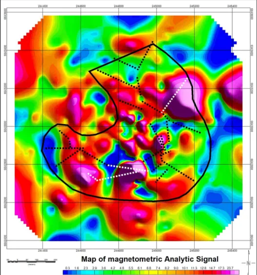
From the total magnetometer ield map, the processing technique was applied for enhancement of magnetic anomalies. In the transformation of the space domain to the time domain through the Fast Fourier Transform (FFT), a map of analytical signals was generated. In this map, the gabbro was characterized by high magnetic suscep-tibility, in contrast to the metassedi-ments of the Vacacaí Metamorphic Complex. However, the ends of the map also present a high magnetic susceptibil-ity, in this case, attributed geostatistical effects due to the absence and small quantity of sample points (Figure 3). The analytical signal ilter has as its
main feature, the positioning of the amplitudes arising immediately above the limits of structures.
With the purpose of a joint analy-sis of magnetometric and geological data, the limits of the intrusive rock obtained in a previous work developed by CPRM in 1995, measured by ield surveys, together with the main struc-tural lineaments, interpreted based on satellite images, were superimposed on the analytic signal map (Figure 4).
In the analytic signal map, it is possible to observe that the magnetic highs are strongly conditioned to the geological structures in the area. In the NE portion, where a more signiicant magnetic high in the order of 27.6 nT is observed, fractures are heading NE-SW, which reinforces the hypothesis of ore concentration in these lineaments.
Figure 3
Map with the calculated
Figure 4 Map of analytic signal, with that of the gabbro (solid line), and structural linea-ments obtained from satellite images (da-shed). The structures highlighted in white
are related to D4 deformation phase.
The Vacacaí Metamorphic Com-plex, itting from the Santa Catarina gabbro is characterized by a multiphase tectonic evolution, where it is possible to discern four phases of deformation (D1, D2, D3 and D4).
The irst three phases generated folds tending to coaxiality in a NE/ SW direction, related to compressive stress towards the SE. The D3 phase is characterized by strike-slip movement with coaxial refolding and generation of folds of normal type and slope axis to NNE and SW. The D4 phase resulted in folds with axial orientation NW/SE,
orthogonal in relation to the structures established in the previous phases.
The gabbro Santa Catarina is un-derstood as a structural basement horst, raised to its present position during the D3 stage by compressive stresses. The compressive stress of the D4 phase gen-erated fractures in the main direction, in an event where there was low-grade metamorphism and probable gold remo-bilization from the metassediments to the gabbro (CPRM, 1995).
The geological context of the study area indicates that the mineralized zones must be contained in fractures. Thus,
after the application of the analytical signal ilter, the generated map shows two zones of high magnetic susceptibil-ity, one in the NE portion and another in the S portion, which can be interpreted as promising for the accumulation of gold and sulides (Figure 3).
The areas with potential pres-ence of mineralized veins in gold and sulides cause large distortions in the local magnetic ield, apparently in an amplitude higher than the distortion caused by the presence of disseminated magnetite along the forming minerals of the gabbro.
4. Conclusion
The image of the amplitudes of the analytic signal determines geomet-ric parameters, such as the location of geological and structural limits. The analytic signal presents as its main feature the placement of the amplitudes aris-ing immediately above the limits of the structure. These aspects are quite evident regarding the magnetometer signature of the intrusive rock, deined by high values
of magnetic susceptibility and quite close to the geological contact deined by geo-logical mapping and ield reconnaissance. In this sense, processing through the analytical signal ilter demonstrated eficacy as an auxiliary tool in the delimi-tation of maic intrusives in metassedi-mentary contexts.
The evolutionary context of the study area is characterized by a polycyclic
The D4 deformation phase resulted in structural lineaments with NE and E-W directions, whose efforts may be related to both the fracturing and opening of spaces within the gabbro, and the remobilization of metals (gold and sulides) derived from the metassedimentary host.
Although the gabbro is a known magnetic rock because of the high con-tent of magnetite, the analytic signal map outlines areas with high magnetic susceptibility within its boundaries, coinciding with structural lineaments in the NS and E-W directions. This fact can be attributed to the possible presence of veins of massive sulide and gold, in
contrast to the occurrence of magnetite crystals widely dispersed among the rock-forming silicates. However, in the absence of magnetic minerals in sedimentary host rocks, the gabbro is characterized by high magnetic susceptibility.
Such structures are present in two different positions of the gabbro and limited by magnetic lows, in a conigu-ration that deines at least two magnetic dipoles with potential for detailing by direct investigation.
Geochemical evidence obtained from samples of stream sediments col-lected in drainages from the gabbro re-vealed a number of particles of gold well
above the regional average. The structural lineaments, mapped in the area, control the network of drainages born in NW por-tions of the gabbro and run towards SE.
In this context, the highlighted areas of high magnetic susceptibility are crossed by two distinct drainages, which subsequently united as a single channel that was used for geochemical sampling at 1 km downstream the area. This set of evidences suggests the presence of ilo-nian mineralization in fractures, some of them subjected to weathering action, with releasing and transport of gold by water action and deposition along the stream sediments downstream of the gabbro.
5. Acknowledgements
The authors are thankful to Na-tional Council for Scientiic and Tech-nological Development - CNPq for
the inancial support whereby process number 470821/2013 (Edital Univer-sal - 2013), and a Coordination for the
Improvement of Higher Level Personnel – CAPES for scholarship.
6. Bibliography
ALVA-VALDIVIA L. M., LÓPEZ-LOERA H. A review of iron oxide transforma-tions, rock magnetism and interpretation of magnetic anomalies: El Morro Mine (Brazil), a case study. Geofísica Internacional, v. 50, n. 3, p. 341-362, 2011.
BATISTA, J. A., BLANCO, J., PÉREZ-FLORES, M. A. Geological interpretation of Eastern Cuba Laterites from an airborne magnetic and radioactive isotope survey.
Geofísica Internacional, v. 47, n. 2, p.99-113, 2008.
BRIGGS I. C. Machine contouring using minimum curvature. Geophysics, v. 39, n.
1, p. 39-48, 1974.
CPRM. Programa levantamentos geológicos básicos do Brasil: Folha Passo do Salsi-nho, Escala 1:50.000, Brasília: CPRM, 1995. 359p.
CPRM. Folha Cachoeira do Sul, Rio Grande do Sul. Escala 1:250.000, Brasília: CPRM, 2000. 86p.
DOYLE, H. Geophysical exploration for gold - a review. Geophysics, v. 55, n. 2, p.
134–146, 1990.
FALLON, T., BACKO, J. Archaean BIF-hosted gold, Mount Morgans, Western Aus-tralia: a geophysical case history. Exploration Geophysics, v. 25, n. 3, p. 166–166,
1994.
GONÇALVES, B., SAMPAIO, E. Interpretation of airborne and ground magnetic and gamma-ray spectrometry data in prospecting for base metals in the central--north part of the Itabuna-Salvador-Curaçá Block, Bahia, Brazil. Interpretation, v.
1, n. 1, p.85–100, 2013.
JACKSON, J. The use of sub-audio magnetics (SAM) in gold exploration – examples from the Yilgarn Craton, WA. Exploration Geophysics, v. 36, n. 2, p.163–169,
2005.
MAAS M. V. R., OLIVEIRA C. G., PIRES A. C. B., MORAES R. A. V. Aplicação da geofísica aérea na exploração mineral e mapeamento geológico do setor sudoeste do Cinturão Cuprífero Orós-Jaguaribe. Revista Brasileira de Geociências, v. 33,
n. 3, p. 279-288 2003.
MOON C. J., WHATELEY, M. E. G., EVANS, A. M. Introduction to mineral ex-ploration. Austrália: Blackwell Publishing, 2006. 499p.
NABIGHIAN M. N. The analytic signal of two-dimensional magnetic bodies with polygonal cross-section: its properties and use for automated anomaly interpreta-tion. Geophysics, v. 37, n. 3, p. 507-517, 1972.
NABIGHIAN M. N. Additional comments on the analytic signal of two-dimensional magnetic bodies with polygonal cross-section. Geophysics, v. 39, n. 1, p. 85-92,
NABIGHIAN, M., GRAUCH, V., HANSEN, R., LAFEHR, T., LI, Y., PEIRCE, J., PHILLIPS, J., RUDER, M. The historical development of the magnetic method in exploration. Geophysics, v. 70, n. 6, p. 33-61, 2005.
OLIVEIRA, R. G. Dados geofísicos. Arcabouço geofísico, isostasia e causas do magmatismo cenozóico da província Borborema e de sua margem continental Nordeste do Brasil. Natal, RN: Universidade Federal do Rio Grande do Norte,
2008. 112f. (Tese de Doutorado do Programa de Pós-Graduação em Geodinâmica e Geofísica).
PAIM S. G., LOPES R. C., Geologia da Região das Minas do Camaquã. Minas do Camaquã. Porto Alegre: Editora Unisinos, 2000, 366p.
RODRIGUES C. R. O., BENNEDETTI O. J, STROHSCHOEN J. R. O. Geologia da faixa II da Folha Passo do Salsinho - RS. Porto Alegre: UFRGS, 1982. 73p.
RODRIGUES, J. A. B. A magnetic survey of mineral resources in northeastern Cuba.
Geofísica Internacional, v. 45, n. 1, p. 39-56, 2006.
SHARMA P. V. Magnetic method applied to mineral exploration. Ore Geology Re-views, Amsterdam, v. 2, n. 4, p. 323-357, 1987.
SÚAREZ A. O., MOROSINI A., ULACCO H., DÚRAN A. C. Geología y geofísica del cuerpo máico-ultramáico Las Cañas, Provincia de San Luis. Serie Correlaci-ón Geológica, San Miguel de Tucumán, v. 28, n. 2, p.151-166, 2012.
SULTAN S. A., MANSOUR S. A., SANTOS F. M., HELALY, A. S. Geophysical ex-ploration for gold and associated minerals, case study: Wadi El Beida area, South Eastern Desert, Egypt. Journal of Geophysics and Enginnering, v. 6, n. 4, p.
345-356, 2009.
TELFORD W. M., GELDART L. P., SHERIFF R. E. Applied Geophysics. New York:
Cambridge University Press, 1990. 784p.
TRIMBLE. GPS Pathinder Systems: receiver manual. Sunnyvalle, Version 1.00. Re-vision B, 2001. 103p.
VELLA, L. Geophysical setting of BIF-hosted gold deposits at Tuckabianna, Western Australia. Exploration Geophysics, v. 25, n. 3, p. 166–166, 1994.