Article
SURVEYING IN THE STUDIES OF THE STABILITY OF EARTHY
CONSTRUCTIONS, FOCUS ON SELECTED HISTORICAL MOUNDS IN KRAKOW (POLAND)
Topografia em estudos de estabilidade de construções primitivas, caso de estudo
de monumentos históricos na Krakovia (Polônia)
Rafał Gawałkiewicz1 Anna Szafarczyk 1
1AGH University of Science and Technology, Faculty of Mining Surveying and Environmental
Engineering, Department of Mining Areas Protection, Geoinformatics and Mining Surveying, 30 Mickiewicza Al., 30-059 Krakow, Poland. E-mail: [email protected]; [email protected]
Abstract:
Mounds, as anthropogenic constructions of a very delicate structure, are subdued to constant changes, which, due to the impact of external factors (prolonged precipitation, tremors) are subdued to deformations in the form of mass movements. These phenomena usually have the character of mild soil creep in time and sometimes, as a result of rapid loss of stability, they are seriously damaged by landslide. This phenomenon causes temporary exclusion of the object from use. In the framework of the protection of these objects, the maintenance was carried out within the preventive measures referring to the construction and surveying monitoring of the geometry changes in time, as a result of phenomena taking place in the ground medium under the influence of environmental factors causing strains. The process of the deformation of mounds is similar to the characteristic, according to the Terzagie’s theory. The application of surveying technologies of high precision allows the monitoring of changes in their geometry in time. The properly defined study area and the proper selection of measurement technology in the aspect of the accuracy of the prediction of changes, can efficiently help in defining the scale of deformations in the decisive process referring to the way of efficient protection of barrows. The article presents the results of point monitoring carried out with surveying technologies within 11 measurement series carried out on the selected measurement base of the Wanda Mound. The use of measurement technologies of integrated and specialist software, allows complex assessment of the degree of deformation and the trends of these changes in time, as well as identifying
anomaly zones in the framework of the landslide monitoring.
Keywords: landslides, geodetic monitoring, ground structures, integrated technologies
Resumo:
drasticamente danificado por erosões. Este fenômeno causa uma exclusão temporária do objeto. Para proteção desses objetos devem ser tomadas medidas preventivas baseadas em monitoramento de estruturas que devem ser realizados sob a influência de fatores ambientais. O processo de deformação de monumentos é similar às características levantadas pela teoria de Terzagie. O emprego de tecnologias de levantamentos propicia o estudo periódico dessas influências. A definição da área de estudo e da tecnologia empregada em termos de acurácia e precisão podem, efetivamente, ajudar nas análises de deformações em processos decisivos para proteção de monumentos. Este trabalho apresenta os resultados obtidos pelo monitoramento do monumento Wanda, onde foram realizadas 11 séries de medidas topográficas. O emprego de técnicas de levantamentos e de softwares específicos permite a determinação do grau de deformação e uma prevenção de mudanças periódicas, bem como, identificar anomalias na
região de monitoramento.
Palavras-chave: Erosão, Monitoramento Geodésico, Estruturas do terreno; Tecnologias integradas
1. Introduction
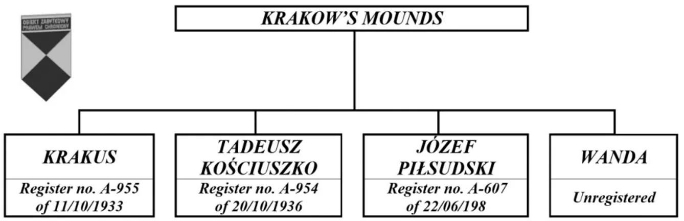
Four mounds with the status of historical structural objects of anthropogenic origin, localized on
local terrain elevations make a beautiful feature of the Krakow’s landscape. They belong to the largest objects of this type in Poland. Nowadays there are more than 330 such objects registered
in Poland, mainly in the southern and south – east part of the country. Two of them i.e. the
Krakus Mound in Krzemionki and Wanda Mound in Mogiła are prehistoric monuments of
Proto-Slavic culture of 7th– 8thcentury, while the Kościuszko Mound on the Blessed Bronisława’s Hill
and Józef Piłsudski Mound in Sowiniec are relatively new constructions, but they belong to the
biggest earthy monuments. Only Sillbury Hill located in England (McAvoy, 2005), among all the European earthy constructions, in the group of mounds and barrows, is bigger in height and
cubature than the Józef Piłsudski Mound (the biggest Polish mound).
Despite their monumental characteristics, making the impression of very durable objects, actually mounds are earthy constructions, very delicate and extremely vulnerable to external factors, i.e. forces of nature and human activities. Three of them, i.e. the Mounds of: Krakus,
Kościuszko and Piłsudski were studied carefully by archaeologists and geologists who attempted
to obtain information on geological structure and properties of grounds forming them, which allowed proper and reliable analysis of the dynamics of the earthy solid exposed to the influence of external factors, as well as the proper selection of security measures. A prehistoric mound of
Wanda in Mogiła (Nowa Huta), despite being the smallest historic anthropogenic object of this
type in Krakow, has not been examined in details, so far. All the four mounds have the status of monuments, but only the Wanda Mound, despite many efforts of local authorities of the Nowa
Huta Quarter and the Society of History and the Monuments of Krakow (Towarzystwo Historii i
Figure 1: The status of Krakow’s historical mounds and the dates of being registered as historical monuments
2. Historic mounds in the Polish law
In Poland, historic objects belonging to the group of archaeological objects are protected by several legal acts, i.e.:
The Act of the Construction Law of 7th July 1994 with later amendments (Dz.U. 1994, no. 89, position 414);
The Act of the protection of historical monuments and the custody over the monuments of 23rd July 2003 with later amendments (Dz.U. of 17th September 2003);
The Act of the Law of Environmental Protection of 27th April 2001 (Dz.U. 2001, no. 62, position 627);
The Act of the state of natural disaster of 18th April 2002 (Dz.U. 2002, no. 62, position 558); The Enactment of the Mayor of the City of Krakow no. 1223/2007 of 4th June 2007
The Act of anti-fire protection of 24 August 1991 (Dz.U. 1991, no. 81, position 351).
These acts regulate the status and provide legal and financial protection to the objects of this kind. They employ the owners or administrators of these constructions to take preventive measures, aimed at keeping the objects in a proper technical state and carrying out security measures. Reliable and substantial sources of geo-spatial information on the state of the construction are, among others, databases on surveying, geology and geophysics.
3. Factors deciding on the scale and speed of mass movements of
anthropogenic constructions
All the anthropogenic constructions are subdued to deformations. The land slide processes
(Krejči et al., 2002) in earthy structures of constructions are usually a result of the coincidence of several factors connected with exposing the mass of ground to:
increased weathering of the ground, causing the increased of permeability and water absorption (Dobrowolski and Mroczek, 2014);
erosion of the ground under the influence of surface waters (long-term and intensive
precipitation) (Eltner and Baumgart, 2015; Handwerger et al., 2013);
wind(Yuan et al., 2012);
mechanical or chemical suffosion;
frost (bursting) (Kümpel and Fabian, 2003);
the impact of drought on the slopes in the form of the cracks in the ground;
expansion of the ground;
pushing the ground towards the scarp, as a result of softening the material in the lower part of
the scarp or the base of the mound caused by the increased pressure;
tremors and vibrations of the ground caused by traffic (transit) and railway located in the
neighbourhood of the construction;
construction works carried out on the earthy construction;
tectonic movements and earthquakes (Brunetti et al., 2014; Lacroix et al., 2015) (a
documented earthquake that caused significant damage of buildings in Krakow took place in 1443).
The mounds are also subdued to deformations as a result of:
construction errors at the first stage of construction (design errors, lack of corrections during
construction of the object);
building errors resulting from false premises referring to preventive measures and works
protecting the top from atmospheric factors and securing the earth masses from infiltration of precipitation waters and proper drainage of these waters beyond the outline of construction
(refers to the mounds: Krakus, Kościuszko and Piłsudski);
specific load.
Hydro-geological conditions and the inclination of slopes mainly shape the processes connected with the mass movements of the ground on the scarps and decide about the direction and scale of the phenomenon. The presented geotechnical objects are constructions made of the mixture of specific compact grounds of variable characteristics of resistance and susceptibility to the water impact. The resistance to cutting (La Gatta, 1970; Bhat et al., 2013) the compact soil masses depends on the compactness and angle of internal friction, and these depend on the type of the mass (mineral and grain composition), water content (humidity), load and changes of these parameters in time. Thus, most problems with the solution of the questions of stability are connected with the most frequently occurring compact grounds, characterized by fine grains of a specific structure, defining resistance and plasticity of the ground. Despite the fact that the mounds were made usually of the mixture of various compact formations obtained from the neighbourhood and the technology of building, the earthy cone is predominantly made in a certain conventional way without any distinct lithological stratification, forming a relatively uniform ground medium.
(Zhang et al., 2015). They are particularly exposed to serious damage or destruction as a result of changeable atmospheric conditions - usually intense and prolonged precipitation. All these circumstances disturb the stability of the construction, triggering the erosion processes and land slide (on the slopes). The mixtures of such grounds, as a result of water saturation, lose their resistance to cutting and change the solid state into the plastic state or, in extreme cases, liquid state. The water in such a structure increases the load of a scarp and causes the spillways pressure. A particular danger for the stability of the scarps in the situation of rapid changes in hydrological conditions and preserving the masses of ground are loams. They are subdued to water impact, increasing the plasticity or liquidating. The water saturated ground acts as grease
causing the slide of the ground masses (Coe et al., 2003). Moreover, damp grounds evaporate
very slowly due to strong capillary forces, making the function of drainage systems more difficult.
It means that the grounds can „react” to the influence of these factors and the results can be seen
without any instruments or - in case of micro-movements - with surveying methods.
It is also connected with loosening the earthy structure as a result of the impact of the phenomenon of mechanical and chemical suffosion. Thus the slope and resistance of scarps usually decreases as a result of the occurrence of a definite impulse, disturbing the condition of the balance of earthy masses. Such an impulse can include sudden heavy rains, characteristic for wet years. Their periodical occurrence determines the characteristic of the changes in the geometry of geotechnical objects.
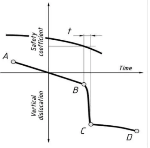
There are many land slide models described in Polish and international literature, which were
graphically interpreted by many researchers (Sozański, 1977; Konderla, 2008). The course of statistically typical landslide according to Terzaghi (Figure 2) is worth to mention. According to
Terzaghi (Sozański, 1977) the decrease of the safety coefficient responsible for the stability of
the slope, can depend on the impact of precipitation waters on the ground masses (graph A –
Figure 2) and water saturation – as a result of long term precipitation and accumulation of waters
in the ground (graph B – Figure 2) or as a result of ground expansion (graph C – Figure 2). The
graphs present the development of landslide phenomena according to Terzaghi (Terzaghi, 1950) in several characteristic cases, which can be identified as phenomena taking place in the structures of the scarps in the mounds.
Figure 3: Stages of the land slide movements of scarps according to Terzaghi
The characteristic of the strains of mound earthy masses in time, is also presented in the graph of
land slide movements of Terzaghi’s scarps (Figure 2), resulting from the influence of precipitation and the impact of surface waters on the cone of the mound, causing water saturation of these masses. Also Figure 3, illustrates the subsequent phases of relatively small changes as a
result of the decrease in the safety coefficient (Reale et al., 2015) and changes in the ground
conditions causing the acceleration of the landslide process and the appearance of landslides and subsequent stage of halting the process (Handwerger et al., 2013). The total result is usually repetitive in time. Figure 3 defines the characteristic of the strains of earthy masses in scarps as a three stage process, consisted of the following stages:
initial phase (movement A – B) – the phenomenon of soil creep or slow slide, which occurs after transgressing the border of safety coefficient equalling one;
phase of quick displacements (movement B – C) the movement of ground masses in a relatively short time;
phase of slow movements (movement C – D), similar to the observed in the initial phase.
4. The impact of precipitation on the technical state and damage
to the Wanda Mound in 2010 and 2012
Usually the state, stability and the dimension of changes in the geometry of the mounds is caused by the range of these factors, and it is difficult to define the individual percentage participation of
each of them (Massey et al., 2013; L’Heureux et al., 2013). The monitoring of these changes can
take place by the registration of arising strains of the earthy surfaces and artificially formed elements (Travelletti et al., 2012). Determining the scale of displacements can be carried out with the following methods:
point, based on the observation and positioning of the points of study grids (grids of control
points) localized on the studied earthy surface of the mound analysed in the 3D space (technologies: precision levelling, GPS-RTK) (Baldo et al., 2009; Mora et al., 2003; Gili et al., 2000);
zonal, based on observation and analysis of natural surfaces (grass slopes) or artificial (paved
i.e.: bases of obelisks localized on the sources of mounds) - technologies: digital photogrammetry, laser scanning, LIDAR, InSAR (Lowry et al., 2013; Zhu et al., 2014;
Avouac and Leprince, 2015).
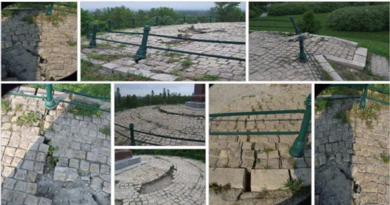
The impact of external movements influencing the construction and longer time exposure to sun, water and wind, cause serious damage to earthy construction or - in extreme situations - its total destruction as a result of the loss of stability. The external factors connected with the long term
and intensive precipitation in summer 2010 led to significant damage of all historical Krakow’s
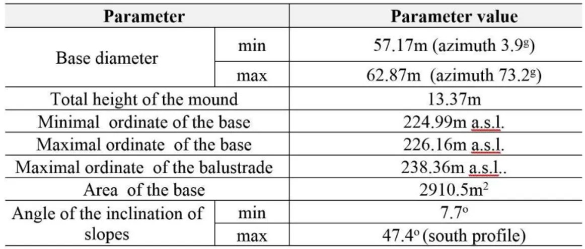
mounds. Also the smallest of them, the Wanda Mound of basic morphometric parameters presented in Table 1, was seriously damaged within the crown. The base of the pavement on the view balustrade was damaged as a result of numerous cracks and fissures, which was illustrated
in Figure 4. Worsening the technical state deepened in summer 2012. As a result of intensive
precipitation there was acceleration of movements in the form of the slide of earthy masses the zone of the construction crown. Thus since July 2012 surveying is carried out in the framework of the point and zonal monitoring to define real changes in geometry of the earthy cone and the speed of these changes in time.
Figure 4: The view of destruction of the upper view balustrade of the Wanda Mound in 2010 and 2012, as a result of intensive and long term precipitation
So far the Wanda Mound is under the administration of the Board of the Municipal Infrastructure
and Transport (Zarząd Infrastruktury Komunalnej i Transportu). Their care mainly includes
mowing the grass on the slopes and the foothill and collecting litter. Only once a provisional protection of the crown construction took place, although in the local press the members of the Nowa Huta District Council many times have been raising the problem of better care over the historical monument and financing the preventive construction works to protect it. Provisional security measures included the removal of the remains of paving blocks and completing the empty spaces with small aggregates to even the edges. Such measure did not allow obtaining reliable information referring to structural deformation of the surface between the measurement
before the renovation works and the following, after the work was completed.
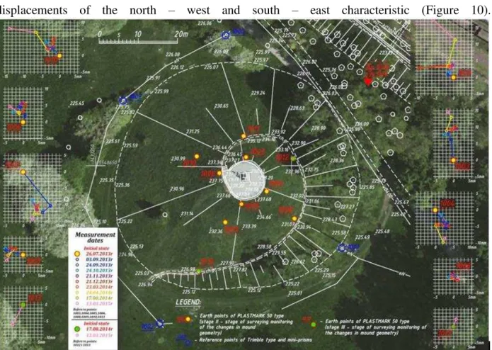
5. Surveying observations in the framework of the point
monitoring of the mound
In June 2012 in the framework of the implemented series of works connected with the inventory
of Krakow’s historical mounds, on the crown around the stone balustrade, 4 points of the control line making a quadrangle and 4 points of the resistance grid localized outside the outline of the
construction (8 points altogether) were put – Figure 5. Using surveying technologies within the
integrated measurements (GNSS, traverses and precise levelling), spatial coordinates of these
points in state systems PL-2000 (horizontal coordinates) and Kronsztadt ’60 (vertical
direction, and the northern slope was moved only slightly in the opposite direction. Also in a vertical plane, within 14 months, significant changes occurred in the heights of the points of the control grid and a significant dispersion of subsidence values occured in the range of 4.0 ÷
-88.2mm. The highest changes in the space dislocation vector WXYH were recorded in point 1005
of the value nearly 142mm in the southern direction. The analysed of time intervals confirmed the correctness of the description of landslide movements, where the values of horizontal displacements exceed the values of vertical disloctions.
Figure 5: Vectors of horizontal 4 control points localized in the neighbourhood of the balustrade (the values cover the period 02.06.2012 ÷ 26.07.2013
- the Google Earth satellite image was applied)
Sudden clear movements of earthy masses in the upper part of the crown within less than 5 weeks (26/07/2013 ÷ 03/09/2013) and change of the characteristics of the slide resulting from the acceleration of the subsidence process, and slowing down horizontal movements made base for the development of the grid of control points. Thus to obtain larger image changes, in March
2013, further 4 points were stabilized at the height of 2/3 of the object – Figure 5. In the
framework of recognizing the characteristic of these movements and the definition of the degree
of unevenness of the deformation process in the earthy cone in: July 2012 – March 2015,
altogether 11 measurement series, in the framework of point monitoring, a grid of control points was made (three times upgraded to more precisely define deformation phenomenon), with the application of integrated precise surveying technologies, i.e.: angular-linear measurements, levelling measurements and laser scanning. This work was carried out in different time intervals, often applying the principle of making measurement sessions, after intensive precipitation or visible effects of the deformation of the upper zone of construction; both in the part of stone balustrade, as well as the earthy part directly adjacent to it.
After third September measurement series, i.e. 03/09/2013 there was a distinct halting of displacements in the horizontal plane of the value of a few millimetres, but changeable directions. These movements, until April 2014, resembled, in the horizontal plane, the turbulent movements of values 1 - 5mm, which was graphically illustrated in Figure 7. One should emphasize that the values of displacements were in 67% significant (Table 2), which means that they exceeded the value of the point situation error, which after equalizing, did not exceed value
mP≤ ±1mm in any of measurement series.
Subsequent distinct movement occurred within the last year, i.e. in the time interval 24/04/2014 ÷ 03/09/2015. These time, the zones in the northern part were activated in the height of 2/3 of the mound, i.e.: points 1010 and 1011. In Table 2 the value of incidental vectors of horizontal
displacements WXY with division into the stages of the stabilization points of the control grid are
given.
Simplification of graphs through filtering certain measurement series characterized by small changes, in case of the value and various directions of displacements allows conclusions that the trend of deformation takes a curved line, which is similar to the phenomena taking place and
documented on the Kościuszko Mound, where the processes taking place in the ground and
Table 2: The values of horizontal dislocation points of the control grid on the Wanda Mound in Krakow
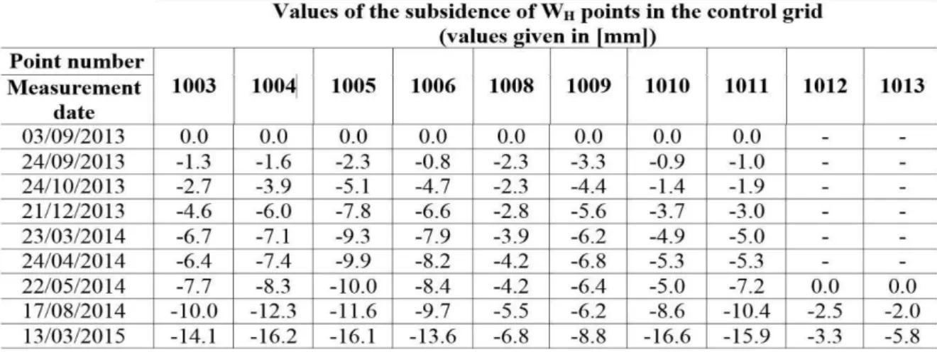
On the other hand, from September 2013 after the time of significant subsidence resulting from a considerable slide of earthy masses clearly slowed down the process of the subsidence of points on the whole surface, even with short-time spring uplift of point 1009 and distinct acceleration of the subsidence values within the 10 latest months (Figure 8). This is confirmed by the intensity of subsidence of the points of maximal values -11.6mm (point 1010) and -8.7mm (point 1011) situated on the height of 2/3 mound on the north side. Again, one can observe asymmetry and distinct change in the preservation of the earthy masses on the whole height of the earthy cone. The southern slope in south-east profile (points: 1005-1009-1013), defines such asymmetry, where points situated on the height of 1/3 and the summit showed the vertical dislocation of values which is nearly 3 times larger than point 1009 situated on the 2/3 height of the mound. In
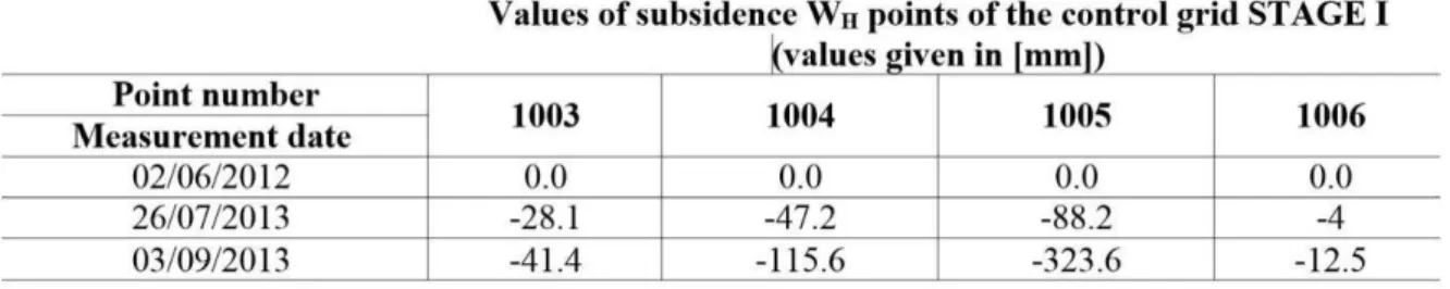
table 3 the subsidence values of WH control points in the discussed time interval: 02/06/2012 ÷
03/09/2013 (STAGE I) located on the summit of the mound (graph Figure 6), while table 4 shows all the control grid points, stabilized on the surface of earthy barrow marked based on the
remaining 9 measurement series, i.e.: in the time interval 03/09/2013 ÷ 13/03/2015 (graph –
Figure 9).
Table 3: The values of subsidence of the control grid points of the Wanda Mound
Referring to the changes that occurred in a similar time interval of nearly 2 years on the largest
of the Polish mounds - the Piłsudski Mound, there is a similarity in the characteristics of these
displacements of the north – west and south – east characteristic (Figure 10).
Figure 7: The image of the localization of control points and reference points and trajectories of control points in the period of 03.09.2013 ÷ 13.03.2015 (the Google Earth satellite image was
applied).
Figure 8: Output vectors of horizontal dislocations of 8 control points located on the surface of the mound (the values cover the period of time 26.07.2013 ÷ 03.03.2015
Figure 9: The graph of vertical dislocations of 8 control points located in the neighbourhood of the balustrade in 03.09.2013 ÷ 13.03.2015
Integrated measurements, i.e. angular – linear measurements, levelling measurements and laser
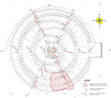
scanning allowed the definition of the scale of horizontal and vertical displacements not only in control points located on scarps, but also stone edge of the balustrade. Thus the data analysis allowed defining the scale of the change and marking, also in this part of the mound, zones of significant deformation index of the ground building the substance of the mound (Figure 11).
Figure 10: The output of vectors of displacements of horizontal points of the control grid
localized on the surface of the Józef Piłsudski Mound in Krakow in 10.2012 ÷ 09.2014
Figure 11: The image of height changes in the surface of the view balustrade at the Wanda Mound and horizontal and vertical displacements of the stone lining, recorded in 12.11.2013 ÷
13.03.2015
6. Summary and conclusions
distribution are responded immediately. A particular role in the protection of historical monuments of geo-technology is attributed to surveying services and scientific centres, having modern instruments. Available integrated measurement technologies, based on cyclic
measurements, today allow precise modelling of deformation processes in time - but first of all –
identify the zones of anomaly, showing the heterogeneity of the ground structure and its susceptibility to external factors. Thus in case of the prehistoric Wanda Mound one should:
1. In order to increase the degree of the „protection” of the Wanda Mound from its further
degradation, one should start activities aiming at registering this construction into the register of historical monuments, which can guarantee getting finances for current maintenance, modernization increasing its tourist attractiveness in terms of the adjustment to current needs and social expectations, or liquidation of damage and taking adequate preventive measures (against land slide and acts of vandalism);
2. Register the Wanda Mound as the area threatened by land slide movements in the
framework of the System of Anti-Landslide Protection (System Osłony
Przeciwosuwiskowej - SOPO);
3. Continue the measurement works in the framework of the carried out surveying
monitoring to define change in geometry of construction with the use of integrated surveying technologies (registration of the effects of the land slide process and the change of the rate of this phenomenon), which allow the registration of surface mass movements, even of sub-millimetre values (in micro-scale);
4. Carry out geological studies to define physical and mechanic parameters of ground
(planned in 2015), as it took place in case of the remaining Krakow’s earthy
constructions of this type;
5. Based on the physical and mechanic analysis of grounds apply a proper way and
technology of scoring the ground as a result of the impact of:
atmospheric factors, i.e. protection from the infiltration of precipitation waters and
thawing factor inside the earthy cone;
human factor, i.e. damage to the roots of the low vegetation overgrowing slopes
protecting the earth masses from erosion of the ground in the layer near the surface (cycling, driving quads on the mounds).
Negative impact of environmental factors on the earthy structure of mounds as elements of historic cultural landscape, require making efficient systems of the monitoring, allowing the definition of the degree of their sensitivity to atmospheric factors and carrying out preventive and repairing programmes. It has been forecasted that climatic changes, regardless the assessment of their causes, have stronger and stronger impact on the occurrence and the scale of cataclysms. Thus one should raise the awareness of the owners or administrators of geotechnical objects susceptible to rapid changes of atmospheric conditions, made by the Governmental
Safety Centre (Rządowe Centrum Bezpieczeństwa) the grid of the threats can be the indicator and
impulse to carry out the preventive measures in construction work and the development of systems monitoring the changes in geometry and the construction, exposed to environmental factors.
ACKNOWLEDGEMENT
The article was financed in the framework of the AGH grant Badania Statutowe No.
REFERENCES
Avouac, J.-P., and Leprince, S. "Geodetic Imaging Using Optical Systems". Reference Module in Earth Systems and Environmental Science. Treatise on Geophysics, (3) Geodesy (2015): 387-424.
Baldo, M., Bicocchi, C., Chiocchini, U., Giordan, D., and Lollino, G. "LIDAR monitoring of mass wasting processes: The Radiocofani landslides". Province of Siena, Central Italy. Geomorphology No.105 (2009): 193-201.
Bhat, R.D., Yatabe, R., Bhandary, N.P. "Study of preexisting shear surfaces of reactivated landslides from a strength recovery perspective". Journal of Asian Earth Sciences No. 77 (2013): 243-253.
Brunetti, M.T., Guzzetti, F., Cardinali, M., Fiorucci, F., Santangela, M., Mancinelli, P., Komatsu, G., and Borselli, L. "Analysis of a new geomorphological inventory of landslides in Valles Marineris", Mars No. 405 (2014): 156-168.
Coe, J.A, Ellis, W.L., Godt, J.W., Savage, W.Z., Savage, J.E., Michael, J.A., Kibler, J.D., Powers, P.S., Lidke, D.J., and Debray, S. "Seasonal movement of the Slumgullion landslide determined from Global Positioning System surveys and field instrumentation". Engineering Geology No. 68 (2003): 67-101.
Dobrowolski, R., and Mroczek, P. "Clay cortex in epikarst forms as an indicator of age and
morphogenesis – case studies from Lublin – Volhynia chalkland (East Poland, West
Ukraine)". Geomorphology, (2014) (Article in Press).
Eltner, A., and Baumgart, P. "Accuracy constraints of terrestial Lidar data for soil erosion measurement: Aplication to a Mediterranean field plot". Geomorphology No. 245 (2015): 243-254.
Gili, J.A., Corominas, J., and Rius, J. "Using Global Positioning System techniques in
landslide monitoring". Engineering Geology No. 55 (2000): 176-192.
Handwerger, A.L., Roering, J.J., and Schmidt, D.A. "Controls on the seasonal deformation of
slow-moving landslides". Earth and Planetary Sciences Letters No.377-378 (2013): 239-247.
Konderla, H. "Stateczność skarp i zboczy w ujęciu Eurokodu 7". Górnictwo i Geoinżynieria
No. 32/2 (2008): 197–204.
Krejči, O., Baroň, I., Bil M., Hubatka, F., Jurová, Z., and Kirchner, K. "Slope movement in the Flysch Carpathians of Eastern Czech Republic triggered by extreme rainfalls in 1997: a
case study". Physics and Chemistry of the Earth, Parts A/B/C, No. 27 (2002): 1567-1576.
Kumpel, H-J., and Fabian, M. "Tilt monitoring to assess the stability of geodetic reference
point in permafrost environment". Physics and Chemistry of the Earth, Parts A/B/C, (28):
(2003): 1249-1256.
Lacroix, P., Berthier, E., and Maquerhua, E.T. "Earthquake-driven acceleration of
slow-moving landslides in the Colca valley, Peru, detected from Pleiades images". Remote Sensing
of EnvironmentNo. 165 (2015): 148-158.
La Gatta, D.P. "Residual strength of clays and clay-shale by rotation shear tests". Harvard
Soil Mechanics (86), Harvard University, Cambridge, USA 1970.
L’Heureux, J.S., Vanneste, M., Rise, L., Brendryen, J., Forsberg, C.F., Nadim, F., Longva,
O., Chand, S., Kvalstad, T.J., and Haflidason, H. "Stability, mobility and failure mechanism
346, (2013): 192-207.
Lowry, B., Gomez, F., Zhou, W., Mooney, M.A., Held, B., and Grasmick, J. "High resolution displacement monitoring of a slow velocity landslide using ground based radar
interferometry". Engineering Geology, No. 166, (2013): 160-169.
Sozański, J. "Stateczność wykopów, hałd i nasypów". Wydawnictwo „Śląsk”, Katowice, (1977): 1-182.
Massey, C.I., Petley, D.N., and McSaveney, M.J. "Patterns of movement in reactivated
landslides". Engineering Geology, No. 159, (2013): 1-19.
McAvoy, F. "Silbury Hill - An assessment of the conservation risks and possible responses
arising from antiquarian and archaeological investigations deep into the Hill". English
Heritage Research & Standards Dept. (2005) .
Mora, P., Baldi, P., Casula, G., Fabris, M., Ghirotti, M., Mazzini, E., and Pesci, A. "Global Positioning Systems and digital photogrammetry for the monitoring of mass movements:
application to the Ca’ di Malta landslide (northern Apennines, Italy)". Engineering Geology,
No. 68. (2003): 103-121.
Reale, C., Xue J., Pan, Z., and Gavin, K. "Deterministic and probabilistic multi-modal
analysis of slope stability". Computers and Geotechnics, No. 66. (2015): 172–179.
Terzaghi, K. "Mechanism of landslides". (41), Harvard University, Department of Engineering (1950).
Travelletti, J., Delacourt, C., Allemand, P., Malet, J.P., Schmittbuhl, J., Toussaint, R., and Bastard, M. "Correlation of multi-temporal ground-based optical images for landslide
monitoring: Aplication, potential and limitation". ISPRS Journal of Photogrammetry and
Remote Sensing, No. 70. (2012): 39-55.
Yuan, Z., Chen, J., Owen, L.A., Hedrick, K.A., Caffee, M.W., Li, W., Schoenbohm, L.M., and Robinson, A.C. "Nature and timing of large landslides within and active orogen, eastern
Pamir, China". Geomorphology, No. 182. (2012): 49-65.
Zhang, X.H., Lu, X.B., Shi, Y.H., and Xia, Z. "Study on the machanical properties of
hydrate-bearing silty clay". Marine and Petroleum Geology, No.67. (2015): 72-80.
Zhu, W., Zhang, Q., Ding, X., Zhao, C., Yang, C., Qu, F., and Qu, W. "Landslide monitoring
by combining of CR-InSAR and GPS techniques". Advances in Space Researche, No. 53.
(2014): 430-439.