POÇOS DE CALDAS, MG
Henrique Nery Cipriani1, José Aldo Alves Pereira2, Rossi Allan Silva3, Sávio Gouvêa de Freitas4, Luciano Teixeira de Oliveira5 (received: December 3, 2009; accepted: November 30, 2010)
ABSTRACT: This study constructed a fi re risk map for the Serra de São Domingos Municipal Park (SSDMP), southern Minas Gerais Sate, Brazil, which harbors Atlantic Forest remnants and endangered species. Geo-processing techniques were used for producing a preliminary risk map for altimetry (a), land slope (e), slope orientation (d), land-use/cover (u) and infl uence of roads and buildings (i). After, the risk maps were overlaid to produce a structural fi re index (SFI)-based risk map for the Park. The SFI was calculated by using the formula SFI = 0,35i + 0,30u + 0,15d + 0,10a + 0,10e. The risks classes were classifi ed as low (0.0-0.9), moderate (1.0-1.9), high (2.0-2.9), very high (3.0-3.9) and extreme (4.0-5.0). All data were processed with 2.5 m base spatial resolution by using the ArcView GIS. According to the SFI calculated, the SSMP area can be divided into the following fi re risk zones: Low (0.93%), Moderate (61.77%), High (31.32%), Very High (4.79%) and Extreme (1.19%). The main risk factor is due to the infl uence of roads and buildings and most fi res start due to anthropogenic causes. The low and moderate risk classes comprehend most of the rainforest area. Clearings and grasslands fi t mainly the High risk class. The most vulnerable area of SSDMP was the Northern area bordering pasture, crops and eucalypt fi elds. The SFI map can be a valuable tool for elaborating a fi re prevention plan in a small conservation unit when few climate and fi re occurrence data are available.
Key words: Atlantic Forest, conservation unit, fi re prevention, on-the-screen visual image interpretation.
ZONEAMENTO DE RISCO DE INCÊNDIOS PARA O PARQUE MUNICIPAL DA SERRA DE SÃO DOMINGOS, POÇOS DE CALDAS, MG
RESUMO: Objetivou-se, com este estudo, produzir um mapa de risco de incêndio para o Parque Municipal da Serra de São Domingos (PMSSD), sul de Minas Gerais, Brasil, que abriga remanescentes de Mata Atlântica e espécies ameaçadas de extinção. Técnicas de Geoprocessamento foram utilizadas para produzir mapas de risco preliminares para altimetria (a), declividade do terreno (e), uso e cobertura do solo (u), orientação de encosta (d) e infl uência de estradas e construções (i). Os mapas foram integrados, gerando um mapa baseado no índice estrutural de risco de incêndio (SFI) calculado pela fórmula SFI = 0,35i + 0,30u + 0,15d + 0,10 a + 0,10e. As classes de risco foram defi nidas como Baixo (0,0-0,9), Moderado (1,0-1,9), Alto (2,0-2,9), Muito Alto (3,0-3,9) e Extremo (4,0-5,0). Os dados foram trabalhados com resolução espacial de 2,5 m utilizando-se o ArcView SIG. A área do PMSSD pode ser distribuída nas seguintes classes: Baixo (0,93%), Moderado (61,77%), Alto (31,32%), Muito Alto (4,79%) e Extremo (1,19%). O principal fator de risco é a infl uência de estradas. As classes de risco Baixo e Moderado abrangem a maior parte da cobertura fl orestal. Clareiras e pastagens ocupam principalmente a classe de risco Alto. A área mais vulnerável do SSDMP é a sua fronteira com pastagens e plantios de café e eucalipto ao norte. O mapa baseado no SFI pode ser um valioso subsídio para a elaboração do plano de prevenção de incêndio de pequenas unidades de conservação com poucos dados relativos ao clima e ao histórico de ocorrência de incêndio disponíveis.
Palavras-chave: Classifi cação visual criteriosa, Mata Atlântica, prevenção de incêndio, unidade de conservação.
1Forest Engineer, Masters student in Soil and Plant Nutrition – Universidade Federal de Viçosa/UFV – Av. Peter Henry Holfs, s/n – Campus Universitário – Viçosa, MG, Brasil – 36570-000 – hncipriani@hotmail.com
2Forest Engineer, Lecturer D.Sc. in Ecology – Departamento de Ciências Florestais – Universidade Federal de Lavras/UFLA – Cx.P. 3037 – 37200-000 – Lavras, MG, Brasil – j.aldo@dcf.ufl a.br
3Forest Engineer, Masters student in Forest Engineering – Departamento de Ciências Florestais – Universidade Federal de Lavras/UFLA – Cx.P. 3037 – 37200-000 – Lavras, MG, Brasil – rossiallan@gmail.com
4Forest Engineer – Instituto Estadual de Florestas/IEF – Rua Misericórdia, 798, Centro – Oliveira, MG, Brasil – 35540-000 – saviogouvea@hotmail.com 5Forest Engineer, Doctoral student in Forest Engineering – Departamento de Ciências Florestais – Universidade Federal de Lavras/UFLA – Cx.P. 3037 – 37200-000 – Lavras, MG, Brasil – oliveiralt@hotmail.com
1 INTRODUCTION
Except for some tropical rainy regions, fi re is the main source of damage to forests throughout the world, affecting soil, vegetation, wildlife and the environment, having an important share in greenhouse gas emissions (SANT’ANNA
For a Conservation Unit (CU) such as the Serra de
São Domingos Municipal Park (SSDMP), which besides
receiving a large number of tourists harbors remnants of endangered species of Atlantic Rainforest, it is essential that there be mechanisms to, effectively, control forest fi res, ensuring its integrity for the welfare of animals, plants and people who make use of the facility in various ways.
Prevention must be part of any fi re control strategy because it does not matter, how good a fi refi ghting scheme might be, it is always better to prevent the fi re outbreak. Nevertheless, in the case of a fi re outbreak, if a good prevention plan is available for implementation, it will allow a faster and more effi cient action.
The geographic information system (GIS) and remote sensing are useful tools for use in prevention plans, since they allow the production of fi re risk maps that indicate regions of the UC prone to fi re outbreaks and which are the main factors responsible for that vulnerability (CHUVIECO et al., 2010; NÚÑEZ-REGUEIRA et al., 2000). Many methodologies have been used in the production of fi re prevention maps, differing mainly in the variables that are used to calculate the fi re risk index (CHUVIECO et al., 2010; FERRAZ; VETTORAZZI, 1998; HERNANDEZ-LEAL et al., 2006; NÚÑEZ-REGUEIRA et al., 2000; OLIVEIRA et al., 2004; RIBEIRO et al., 2008).
According to its time scale, a fire risk index can be classifi ed as structural, dynamic or integrated (JRC, 2001, apud FREIRE et al., 2002). The fi rst one is composed only of factors that remain unaltered for a relatively long time, such as topography and land-use; the second one is calculated by using parameters that are constantly changing (weather conditions, litter moisture etc.); and the third type use both types of data. Although integrated fi re indexes are considered the most reliable, they require more data to be calculated (CHUVIECO et al., 2010). Nonetheless, structural fi re indexes have been used successfully in the production of many maps with few adaptations (DALCUMUNE; SANTOS, 2005; FREIRE et al., 2002; RIBEIRO et al., 2008).
In the case of the Serra de São Domingos
Municipal Park, where there is lack of climatologic and fi re history data, the adoption of a simpler methodology based on static physical variables might prove useful for a preliminary approach on the fi re risk assessment for the CU. In this regard, the objective of this study was to produce a fi re risk map for the SSDMP to subsidize its fi re prevention plan.
2 MATERIAL AND METHODS 2.1 Location
The Serra de São Domingos Municipal Park
is located in the northern region of Poços de Caldas
city, southern Minas Gerais Sate, Brazil, coordinates 21°46’25’’S and 46º34’10’’W (Christ statue). It covers an area of 367.60 ha, 74.36% being occupied by rainforest, 13.26% by grassland vegetation (the highest part of the Park), 6.09% by pasture, 1.04% by exposed soil, 1.24% by crops (mainly coffee), 0.46% by urbanized areas and 0.23% by inactive bauxite mines. There are no water bodies of signifi cant size in the Park, but several springs can be found scattered around the rainforest area.
Urbanized areas comprehend the Park roads and touristic spots, which are the Christ Redeemer statue, the astronomic observatory (currently disabled), the aquarium, the cable car and the free-fl ight ramp, all located around the hilltop. There are also two touristic spots located at the lowest part of the Park hill, Recanto Japonês (a
Japanese-style garden) and Fonte dos Amores (“love spring”).
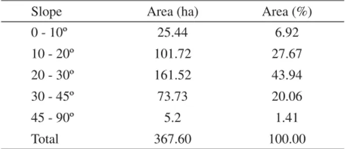
The land slope classes found in the Park are varied, with a predominance of the mountainous to wavy relief (Table 1). The fl at lands are concentrated on the highest part of the Park. Only two types of soil are found within the Park: Red-Yelloow Podzolic, the most common, and Cambisol (SOUZA et al., 2007).
Table 1 – Land slope at Serra de São Domingos Municipal Park, Minas Gerais State, Brazil.
Tabela 1 – Declividade do terreno no Parque Municipal da Serra de São Domingos, Minas Gerias, Brasil.
Slope Area (ha) Area (%)
0 - 10º 25.44 6.92
10 - 20º 101.72 27.67
20 - 30º 161.52 43.94
30 - 45º 73.73 20.06
45 - 90º 5.2 1.41
Total 367.60 100.00
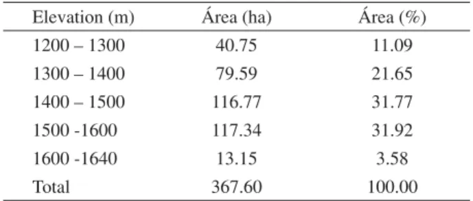
Table 2 – Elevation at Serra de São Domingos Municipal Park, Minas Gerais State, Brazil.
Tabela 2 – Elevação no Parque Municipal da Serra de São Domingos, Minas Gerais, Brasil.
Elevation (m) Área (ha) Área (%)
1200 – 1300 40.75 11.09
1300 – 1400 79.59 21.65
1400 – 1500 116.77 31.77
1500 -1600 117.34 31.92
1600 -1640 13.15 3.58
Total 367.60 100.00
Poços de Caldas climate is classifi ed as Cwb type
according to the Köppen classifi cation (hot temperate with rains in summer). Considering the 1931-1960 climate normal, Poços de Caldas rainy season runs from
September to March, with an average total of 1,478.7 mm for the period. The total average annual precipitation is 1,695.5 mm. The average temperatures of the coldest (June) and hottest (February) months are 14.3 ºC and 20.5 ºC, respectively.
Not only does the Park receive a large number of tourists annually, it also preserves a valuable Atlantic Forest fragment. Nineteen threatened plant species have already been found in fl oristic studies made in the Park, including critically endangered species (Euterpe edulis
and Persea rufotomentosa). Researches on the fauna are
currently in progress, but a vulnerable monkey group (Cebus sp.) and some endemic frog species are known to
reside in the Park. 2.2 Methods
Preliminary risk maps were produced for each variable used to compose the fi nal risk map: road system and buildings, altitude, land slope, slope orientation and land-use and cover. The land-use/cover map was produced from a SPOT V satellite image (date: 09-28-2006; spatial resolution: 2.5 m) and an aerophotogrammetric survey (year 1997; spatial resolution: 0.6 m). Aiming at maximizing the land-use and cover map precision, a systematic on-the-screen visual image interpretation approach was used to delineate the land-use/cover classes after the automatic classifi cation. The other maps were made from digital fi les with planialtimetric data provided by the Poços de Caldas
City Hall. All data were processed using the ArcView GIS with the Spatial Analyst extension, with 2.5 m base work spatial resolution, Datum SAD 69 and UTM-Fuse 23.
Each variable was categorized into classes and each of these classes received a coeffi cient value that represents its risk for the occurrence or spreading of fi re in comparison to the other classes within the same variable. The coeffi cients ranged from one (low risk) to fi ve (extreme risk), as used by Oliveira et al. (2004).
The altimetric variation of the Park was divided into two classes, as shown in Table 3. The higher the altitude, the lower the risk, since higher altitudes indicate less oxygen concentration and lower temperatures, which hinder the spreading of fi re (SOARES; BATISTA, 2007).
Table 3 – Fire risk and coeffi cients due to the elevation at Serra de São Domingos Municipal Park, Minas Gerais State, Brazil. Tabela 3 – Risco de incêndio e coefi cientes devido à elevação no Parque Municipal da Serra de São Domingos, Minas Gerais, Brasil.
Altitude Risk Coeffi cient
Above 1400 m Low 1
1400 m and below Moderate 2
Source: Adapted from Salas and Chuvieco (1994).
The land slope was divided into fi ve classes in which the higher the declivity, the higher the coeffi cient (Table 4). Fire tends to spread out more intensely on sloping grounds due to the convection of heat to the combustible material located on the upper part. This causes the material to dry faster and burn in a more violent way (SOARES; BATISTA, 2007). Rugged topography also affects combat operations because it hampers the movement of vehicles and people.
Table 4– Fire risk and coeffi cients due to the land slope and orientation at Serra de São Domingos Municipal Park, Minas Gerais State, Brazil.
Tabela 4 – Risco de incêndio e coefi cientes devido à declividade e orientação do terreno no Parque Municipal da Serra de São Domingos, Minas Gerais, Brasil.
Slope Orientation Risk Coeffi cient
Until 14.9º South Low 1
15.0 – 24.9º East Moderate 2
25.0 – 34.9º Plain High 3
35.0 – 44.9º West Very high 4
45.0º and above North Extreme 5
The slope orientation infl uences on the fi re risk inasmuch as it is related to the incidence of sunlight on the surface. The more direct the light incidence is, the higher the temperature and the lower the relative humidity. This causes the combustible material to dry faster and favors the fi re spreading (SOARES; BATISTA, 2007). Table 4 shows the coeffi cient assigned to each sun exposure condition.
Regarding the infl uence of urban areas and roads, the Park was divided into two classes (Table 5): one considered under the infl uence of the road system and buildings and another class considered to be beyond the infl uence of roads and buildings. The fi rst class represents the entire Park area within 15 m of distance from any road or building. The remaining areas were included in the second class. Nine land-use/cover classes were identifi ed at the SSDMP, which were grouped into four risk classes (Table 6).
Table 5– Fire risk and road and building infl uence coeffi cients at Serra de São Domingos Municipal Park, Minas Gerais State, Brazil.
Tabela 5 – Risco de incêndio e coefi cientes devido à infl uência de estradas e edifi cações no Parque Municipal da Serra de São Domingos, Minas Gerais, Brasil.
Infl uence of road system
and buildings Risk Coeffi cient
Beyond infl uence Low 1
Under infl uence Extreme 5
Source: Adapted from Salas and Chuvieco (1994).
Table 6– Fire risk and coefficients due to land use at Serra de São Domingos Municipal Park, Minas Gerais State, Brazil.
Tabela 6 – Risco de incêndio e coefi cientes devido ao uso do solo no Parque Municipal da Serra de São Domingos, Minas Gerais, Brasil.
Land use Risk Coeffi cient
Water, buildings, rainforest
and exposed soil Low 1
Agriculture and mines Moderate 2
Afforestation Very high 4
Pasture and grassland Extreme 5
Source: Adapted from Oliveira et al. (2004).
The integration of the preliminary maps was conducted with the aid of a balance model to which importance degrees (weight) were assigned to each variable, based on the analysis of the Park fi re occurrence history (Table 7). The analysis indicated that the infl uence of the road system and buildings are the most relevant item composing the fi re risk index, since most of the occurrences took place at or near tourist spots.
Table 7 – Number of fi re occurrences for the years 2005, 2006 and 2007 at the Serra de São Domingos Municipal Park (Minas Gerais State, Brazil), and its surroundings.
Tabela 7 – Número de ocorrências de incêndio para os anos de 2005, 2006 e 2007 no Parque Municipal da Serra de São Domingos (Minas Gerias, Brasil) e seu entorno.
Year Occurrences Causes Occurrence places
2005 5
Two criminal and three unknown
One in Fonte Leãozinho, one in the Caldas da Rainha Hotel ruins and
three non-specifi ed
2006 6 All unknown
One in Asa Norte, one in a cloverleaf leading to the Christ statue and
four non-specifi ed
2007 13
One criminal and 12 unknown
One in a pasture area, one in the free-fl ight ramp, one in the road leading to Pedra Balão,
one in the Caldas da Rainha Hotel ruins, one
in a cloverleaf leading to the Christ statue, two
near the Christ statue and six non-specifi ed
The resulting model, adapted from Chuvieco and Congalton (1989), calculates a structural fi re index (SFI) for the Serra de São Domingos Municipal Park, as shown
below:
SFI = 0,35i + 0,30u + 0,15d + 0,10a + 0,10e
in which i, u, d, a and e represent, respectively, the
Table 8 – Fire risk ranks and their coeffi cients for the Serra de São Domingos Municipal Park, Minas Gerais State, Brazil. Tabela 8 – Classes de risco de incêndio e seus coefi cientes para o Parque Municipal da Serra de São Domingos, Minas Gerais, Brasil.
Risk Coeffi cient
Low 0.0 – 0.9
Moderate 1.0 – 1.9
High 2.0 – 2.9
Very high 3.0 – 3.9
Extreme 4.0 – 5.0
Source: Adapted from Oliveira et al. (2004).
3 RESULTS AND DISCUSSION
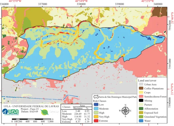
The fi re risk map produced can be viewed in Figure 1. It shows that all fi ve risk classes are present in
the Park area, but they are not evenly distributed. The Moderate risk class alone, for instance, comprehends 61.77% of the Park’s area, whereas only 0.93% fi tted the Low risk class. Also, it can be observed a relatively clear pattern among the risk classes regarding their location within the Park, i. e., there are well-defi ned zones for each risk class.
This uneven distribution of the fi re risk classes reinforces the importance of using multiple factors to compose the fi re risk index. The native forest land-cover class, for example, is almost entirely under the Moderate risk class, even though it has been ranked as a low risk feature (Table 6). This “promotion” in the native forest fi re risk class was due mainly to the infl uence of the land slope and the slope orientation, since most of the forest is located on the rugged part of the Park.
Figure 1 – Fire risk map for the Serra de São Domingos Municipal Park, Minas Gerais State, Brazil.
The SSDMP topography is conducive to the rapid spreading of fi res, as most of the area has slopes superior to 20º (Table 1). However, the negative effects of local topography are alleviated by two factors: the higher slopes are found in the lower part of the Park, where most of the rainforest is located and the fl ow of visitors is lower; and the roads are well-maintained, giving access to the upper part of the conservation unit, aiding fi refi ghting and rescue operations.
Encompassing 31.32% of the Park area, the High risk class is mainly composed of the grassland vegetation that occupies the highest part of the Park and several scattered spots within the native forest areas (the Moderate risk zone). These spots represent some clearings as well as some steep and West-oriented slopes, drawing attention to the existence of vulnerable spots within the forest. Fire outbreaks at some of this spots will certainly menace the UC’s most preserved feature, besides being areas of diffi cult access. Therefore, the fi re prevention plan must include some steps to avoid great damages, such as the closing of some tourist trails that cross those areas and the setting of some water abstraction points close to them.
Many places that are under the road infl uence (an extreme risk factor) but are on less rugged terrain or above 1,400 m were also fi t in the Moderate risk class. The remaining of the areas under the infl uence of roads and buildings fi tted the Very High or the Extreme risk classes, comprehending 5.90% of the Park.
No place beyond the influence of roads and buildings was fi t in the Extreme risk class. Although corresponding to just 1.19% of the Park area, this class deserves keen attention, since it encompasses places with relatively high traffi c and plantations (coffee and eucalypt). It is worth mentioning that commercial plantations within Natural Municipal Parks are forbidden by Brazilian Law (BRASIL, 2000). These features will probably be removed within some years from the implementation of the Park Management Plan.
From the fi re risk map and the fi re occurrence history it is possible to visualize that the SSDMP is naturally protected against fi res. Coupled with the predominance of rainforest, Poços de Caldas climate also contributes
to the low number of fi re occurrences in the history of SSDMP. Other important factors are the CU’s small size and location. Its monitoring is made directly from some high-placed spots in the city around the Park, and all fi refi ghters and equipments are also mobilized from the city. However, this is not the ideal situation for the Park’s safety.
Firstly, the dependence entirely on the city for its protection might compromise SSDMP if a fi re occurs while most equipments and fi refi ghters are mobilized in another fi re occurrence. It is worth mentioning that Poços de Caldas Fire Department serves other small cities close to Poços de Caldas. Secondly, the formation of a fi re brigade
for the Park would provide trained people not only to fi ght against fi res and act in rescue operations but also to head fi re prevention campaigns for tourists and townspeople.
The fi re risk map also revealed the existence of a particularly vulnerable strip along the Northern border of the Park, which confronts with pasture, exposed soil and eucalypt plantations. There is only a dirt road separating these high-risk features from the Park. Since most of the fi res in the SSDMP history have an anthropogenic cause (Table 7), a consciousness-raising campaign with the Park’s neighbors might be even more productive than the establishment of fi rebreaks. The Brazilian Law also determines that, within some distant from any CU (the buffer zone), more environment-friendly agricultural practices must be adopted by farm owners (BRASIL, 2000).
In fact, the use of a structural fi re index to produce a fi re risk map has proved useful as a preliminary approach, identifying the most vulnerable zones within the Park. It will certainly aid the Management Plan team in the elaboration of the fi re prevention plan. The risk map also revealed what is needed to increase its accuracy, if a better map is to be produced in a future Management Plan review: climate data and more detailed occurrence reports.
Since there is no climate station in Poços de Caldas
and the occurrence reports are extremely simplistic, the adoption of an integrated fi re risk at this point is unviable. However, if a climate station is settled in the Park and more precise information is included in the occurrence reports, such as GPS locations of fi re focus and burned area extension, it might be possible to have such an index for, perhaps, the second review of the Management Plan, which is usually reviewed every fi ve years. In this case, a map showing not only the most vulnerable areas but also the fi re outbreaks most vulnerable periods might be producible with these relatively simple and available tools.
4 CONCLUSIONS
- The main fi re risk factors at the Serra de São
Domingos Municipal Park are the infl uence of roads
- Most of the rainforest area fi t the Low and the Moderate risk classes.
- Clearings and grasslands fi t mainly the High risk class.
- The most vulnerable area of SSDMP is its Northern part, bordering pasture, crops and eucalypt fi elds.
- The structural fi re index risk map is a valuable tool for performing a fi re prevention plan in a small conservation unit with few climate and fi re occurrence data available.
5 ACKNOWLEDGEMENTS
The authors thank the Poços de Caldas authorities
and workers that provided assistance throughout the carrying out of this research: Corpo de Bombeiros, Guarda Verde, Guarda Municpal and Departamento de Proteção
Ambiental. The fruitful comments from the anonymous
revisers are also greatly acknowledged.
This work was fi nanced by the Poços de Caldas City
Hall in cooperation with Fundação de Desenvolvimento Científi co e Cultural (FUNDECC).
6 REFERENCES
BRASIL. Lei n. 9.985, de 18 de julho de 2000. Regulamenta o art. 225, § 1º, incisos I, II, III e VII da Constituição Federal, institui o Sistema Nacional de Unidades de Conservação da Natureza e dá outras providências. Brasília: Congresso Nacional, 2000. 23 p.
CHUVIECO, E.; CONGALTON, R. G. Application of remote sensing and geographic information systems to forest fi re hazard mapping. Remote Sensing of Environment, New York, v. 29, p. 147-159, 1989.
CHUVIECO, E. et al. Development of a framework for fire risk assessment using remote sensing and geographic information system technologies. Ecological Modelling, v. 221, p. 46-58, 2010.
DALCUMUNE, M. A. B.; SANTOS, A. R. Mapeamento de índice de risco de incêndio para a Região da Grande Vitória/ ES, utilizando imagens do satélite LANDSAT para o ano de 2002. In: SIMPÓSIO BRASILEIRO DE SENSORIAMENTO REMOTO, 12., 2005, Goiânia. Anais... Goiânia: INPE, 2005. p. 1485-1492.
FERNANDES, M. R. et al. Poços de Caldas: caracterização de ecossistemas. Belo Horizonte: EMATER-MG, 2003. 56 p.
FERRAZ, S. F. B.; VETTORAZZI, C. A. Mapeamento de risco de incêndios fl orestais por meio de sistema de informações geográfi cas (SIG). Scientia Forestalis, Piracicaba, v. 53, p. 39-48, 1998.
FREIRE, S.; CARRÃO, H.; CAETANO, M. R. Produção de cartografi a de risco de incêndio fl orestal com recurso a imagens de satélite e dados auxiliares. 2002. Available in: < http://www.igeo.pt/gdr/pdf/Freire2002.pdf>. Access in: 8 July 2010.
HERNANDEZ-LEAL, P. A.; ARBELO, M.; GONZALEZ-CALVO, A. Fire risk assessment using satellite data. Advances in Space Research, v. 37, p. 741-746, 2006.
NÚÑEZ-REGUEIRA, L.; PROUPÍN-CASTIÑEIRAS, J.; RODRÍGUEZ-AÑÓN, J. A. Design of risk index maps as a tool to prevent forest fi res in the hill-side zone of Galicia (NW Spain). Bioresource Technology, v. 73, p. 123-131, 2000.
OLIVEIRA, D. dos S. de et al. Zoneamento de risco de incêndios fl orestais para o estado do Paraná. Floresta, Curitiba, v. 34, n. 2, p. 217-221, 2004.
RIBEIRO, L.; KOPROSKI, L. P.; STOLLE, L.; LINGNAU, C.; SOARES, R. V.; BATISTA, A. C. Zoneamento de riscos de incêndios fl orestais para a fazenda experimental do Canguiri, Pinhais (PR). Floresta, Curitiba, v. 38, n. 3, 2008.
SALAS, J.; CHUVIECO, E. Geographic information systems for wildland fi re risk mapping. Wildfi re, v. 3, n. 2, p. 7-13, 1994.
SANT’ANNA, C. de M.; PEREIRA, J. A. A.; BORÉM, R. A. T. Prevenção e combate a incêndios fl orestais. Lavras: UFLA/FAEPE, 2001. 88 p.
SOARES, R. V. Incêndios fl orestais: controle e uso do fogo. Curitiba: FUPEF, 1985. 213 p.
SOARES, R. V.; BATISTA, A. C. Incêndios fl orestais: controle, efeitos e uso do fogo. Curitiba, 2007. 264 p.