Structural modeling based on sequential restoration of gravitational salt
deformation in the Santos Basin (Brazil)
Sávio Francis de Melo Garcia
a,*, Jean Letouzey
b, Jean-Luc Rudkiewicz
b, André Danderfer Filho
c,
Dominique Frizon de Lamotte
daPetrobras E&P-EXP, Rio de Janeiro, Brazil bIFP Energies Nouvelles, France
cUniversidade Federal de Ouro Preto, Ouro Preto/MG, Brazil dUniversité de Cergy-Pontoise, France
a r t i c l e
i n f o
Article history:
Received 8 December 2010 Received in revised form 22 November 2011 Accepted 2 February 2012 Available online xxx
Keywords:
Salt tectonics section restoration Santos Basin passive margins South Atlantic deep water
a b s t r a c t
The structural restoration of two parallel cross-sections in the central portion of the Santos Basin enables afirst understanding of existent 3D geological complexities. Santos Basin is one of the most proliferous basins along the South Atlantic Brazilian margin. Due to the halokinesis, geological structures present significant horizontal tectonic transport. The two geological cross-sections extend from the continental shelf to deep waters, in areas where salt tectonics is simple enough to be solved by 2D restoration. Such cross-sections display both extensional and compressional deformation. Paleobathymetry, isostatic regional compensation, salt volume control and overall aspects related to structural style were used to constrain basic boundary conditions. Several restoration algorithms, such as simple shear,flexural slip and free methods, were used to restore the sedimentary deformation, including salt gravity gliding. The results of the 2D restoration are consistent withfive major sequences of sedimentary evolution: (1) the brittle pre-salt deformation, (2) the significant and fast salt deposition, (3) the initial post-salt deformation with predom-inant rafting tectonics, (4) the Late Cretaceous progradational deposition and coeval development of compressional minibasins, and (5) the Cenozoic sedimentary deposition, with less intense salt tectonics. A 1D subsidence analysis based on the 2D restored results is shown as a useful restoration control tool. The 1D results indicate that an initially proximal infill evolves towards distal regions under salt tectonics control. The 1D diagrams also record the history of the overburden movements through lateral depocenter migration in minibasins areas, submitted to large horizontal salt spreading. The results highlight an important isostatic movement during salt deposition, large but not enough to eliminate a needed depression to accommodate the thick evaporites. By quantifying the halokinetic lateral deformation through time, the results suggest less intensity of the phenomenon throughout the Paleogene, with minor impacts on the petroleum system in this period.
Ó2012 Elsevier Ltd. All rights reserved.
1. Introduction
Salt tectonics is one of the most complex deformation processes operating in sedimentary basins. Most current methods of sequential restorations imposed to geological events, however, are based on simplified geometrical approaches. Several poorly controlled simplifications are generally required to simulate such mode of deformation, and are not really integrated with geological processes and properties, limiting applicability and effectiveness of the
restoration methods. Numerical tools are needed to control both decompaction andflexural isostasy in cases in which there are major changes in properties, such as density and compressibility, between evaporites and other sediments.
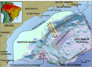
The study area in the deep water of the Santos Basin is intensely deformed by salt tectonics. This passive margin basin is situated offshore Southeastern Brazil, the most prolific petroleum province of the South Atlantic (Fig. 1). The deep offshore region, close to the study area, constitutes a new frontier for petroleum exploration. The basin was developed upon stretched and thinned continental crust of a ruptured Gondwanian margin (Zalán et. al., 2011). The wide expression of the Santos Basin bathymetry gives rise to the São Paulo Plateau, which was developed over a thick salt layer, a fundamental element of the basin evolution.
*Corresponding author. Present address: Petrobras E&P-EXP, Av. Chile, 330,13thfloor, Rio de Janeiro, ZIP 20031-170, Brazil. Tel.:þ55 21 2144 0613; fax:þ55 21 2144 1818.
E-mail addresses: [email protected], [email protected]
(S.F.deM. Garcia).
Contents lists available atSciVerse ScienceDirect
Marine and Petroleum Geology
j o u r n a l h o m e p a g e : w w w . e l s e v i e r . c o m / l o c a t e / m a r p e t g e o
0264-8172/$esee front matterÓ2012 Elsevier Ltd. All rights reserved.
Several authors, such asGuerra (2008), Rouby et al. (1993)and Szatmari and Demercian (1993), discussed the evolution of the Santos Basin using restoration methods. Cobbold et al. (2001), Meisling et al. (2001)and other authors have also interpreted the complex thin-skinned deformation above the Aptian salt in this basin using structural analyses and regional interpretation. More recently, a new framework including a failed sea floor spreading center in the southern limit of the basin as well as an outer high located on the São Paulo Plateau have been described in several papers and presentations (Braga et al., 2003, Carminatti et al., 2008, Scotchman et al., 2006), highlighting the diverse nature of the underlying basement.
In this work, a comprehensive restoration technique integrating 1D burial geohistories, salt amount monitoring and regional setting constraints as supplementary calibration tools is applied in order to minimize the strong impact of simplifications on basin evolution results. Paleobathymetry models,flexural isostasy and the moni-toring of the variation of thicknesses within a consistent structural style are used to guide and constrain all restoration steps. There-fore, the structural modeling character of this work is not just a technique application but also a geological methodology aimed to integrate concepts and data.
2. Geological setting
The Santos Basin constitutes a good example of a passive margin basin,filled by sediments deposited during rift and drift phases. It results from an asymmetrical partition of the Gondwanian“ super-continent”whereby the Brazilian rifted margin remained wider than the conjugate African margin. The Santos Basin spreads over 3.52 x10⁵km2down to 3000 m water depth. The current knowledge of its architecture comes from more than one hundred wells and numerous 2D and 3D seismic surveys. It is bounded to the Northeast by the Cabo Frio High and to the Southwest by the Florianópolis Platform (Fig. 1). The studied area covers around 6000 km2.
2.1. Stratigraphy
The stratigraphic framework of the Santos Basin presented herein (Fig. 2) is in agreement with the general proposal ofMoreira et al. (2007). The maximum sedimentary thickness of the Santos Basin is approximately 12 km (Pereira and Macedo, 1990). The crystalline basement outcropping onshore is characterized by granites and gneisses of Precambrian age (Neoproterozoic Ribeira Belt). The Guaratiba Group represents the carbonate, siliciclastic and evaporitic sediments of the Camboriu, Piçarras, Itapema, Barra Velha and Ariri Formations, deposited before the drift phase, during periods of major and minor fault activations (rift phase). The significant basaltic volcanism of the Camboriu Formation that underlays these formations and unconformably covers the pre-Figure 1.Regional location map outlining the study area (red polygon) including two
restored cross-sections (black lines), six available wells (yellow circles) and four studied pseudo-wells (red circles). Contours represent water depth in meters, rein-forced by the blue shading seafloor topography. Notice the aborted spreading center in the southern region, and its northward propagation along a pre-salt fault trend. Its possible continuity within the study area could account for a local crustal thinning anomaly.
Cambrian basement is regarded as the economic basement for petroleum exploration. These Neocomian basalts were followed by continental sedimentation of the Piçarras and Itapema Formations, in half-grabens formed by faulting and block rotation during the initial rift phase (Barremian).
An unconformity separates the Barremian sequences from the overlying Barra Velha Formation, which was deposited during the Aptian in a relatively less active fault system. This Aptian package is composed of carbonates and shales, typical of a transitional envi-ronment, from continental to shallow marine. The Late Aptian salt sequence, recorded by the Ariri Formation, is about 2500 m-thick on average. Such salt formation was unconformably deposited above Late Aptian syn-rift limestones, in a very short period of time, during the transition from continental to oceanic conditions. The salt layer extends across the West African and Brazilian continental margins (Karner and Gamboa, 2007), and was deposited under high sedi-mentation rates, in the order of 1 km over a period of 0.5 Ma (Dias, 1998).
There are three major sequences overlying the Guaratiba Group, composing the drift phase: the Camburi, Frade and Itamambuca groups (Fig. 2). These groups comprise Albian to Cenomanian sequences, an intervening Late Cretaceous progradational episode, and the Cenozoic sequence, respectively. The post-salt sequences were deformed by gravity-driven tectonics with variable displace-ments along the basin (Assine et al., 2008), mainly due to heteroge-neities of the salt thickness, preexistent relief and progressive basement tilt.
The Albian to Cenomanian sequences of the Camburi Group include thefirst deposits clearly related to the drift evolution after the deposition of the evaporites. Proximal siliciclastic sediments, shallow-water limestones in the continental shelf, and marls and shales in the distal basin were deposited during Albian time. The overlying Cenomanian sequence records deltaic and alluvial silici-clastic proximal fans, with shales and marls from the shelf to distal
basin regions. Sand-rich gravity flows are described in distal structural lows controled by salt tectonics. This sedimentary package represents the onset of a retrogradational pattern that accounts for the largest marine transgression in the Santos Basin and which culminated in the Turonian oceanic anoxic event (OAE-2 event,Arai, 1988).
Most of the Late Cretaceous siliciclastic progradational sequences were deposited in continental paleoenvironments, reflecting a shift of the continental shelf limits towards the offshore. After a strong erosional episode around the Cretaceous-Cenozoic limit, a basin-wide regressive episode gradually shifted the coastal line about two hundred kilometers eastward, allowing the development of a wide prograding depositional wedge. The Cenozoic sedimentary sequences of the Itamambuca Group include sediments deposited from proximal alluvial fans (Ponta Aguda Formation) to distal marine shales and sandstones (Marambaia Formation), with occurrences of carbonate platforms (Iguape Formation), overlain by the most recent shelf sedimentation (Sepetiba Formation). The greatest geographic distribution of the Ponta Aguda Formation is recorded from the Early to Middle Paleogene, reaching a maximum thickness of 2200 m. The Iguape Formation is recorded from Oligocene to present day, reaching a maximum thickness of 2700 m. The pelites of the Marambaia Group are interlayered with sandy bodies of the Maresia Member which are considered as meandering channels or fans in less confined batial areas. Finally, the coarse- to fine-grained sandstones and coquinas of the Sepetiba Formation were deposited on the continental shelf during the last 4.2 Ma.
Fifteen horizons were interpreted on the 2D seismic sections and were tied to the stratigraphic chart of Moreira et al. (2007) (Fig. 2). These horizons were used to build two structural cross-sections (Fig. 3), which are around 120 km long and less than 20 km apart. These cross-sections were subsequently used as input data for the 2D structural restoration analysis, were special atten-tion was given to the salt tectonics during the drift phase.
2.2. Regional structural framework
The structural inheritance presented herein is based mainly on previous studies of several authors in the literature. Rifting occurred in the Santos Basin from Late Jurassic to Early Cretaceous along pre-existing structures (Pereira and Macedo, 1990). The oldest sedi-mentary record of the rift phase in the Santos Basin dates about 135 Ma ago (Moreira et al., 2007). Basement heterogeneities have controlled the main rift architecture through time (horst and grabens bounded by normal faults) (Zalán et al., 2011). Long NE-trending lineaments are identified among the most significant heterogeneities. Those structures have been consistently mapped onshore and can also be observed offshore (Braga et al., 2003), at least as far as the Santos hinge line (Fig. 1). Reactivations of pre-existing lineaments and coeval shear zones controlled the evolu-tion of the coastal mountain ranges (Serra do Mar and Mantiqueira) and intervening Cenozoic onshore grabens (e.g., Almeida, 1976; Zalán and Oliveira, 2005); as well as the compartmentalization of the basin offshore.
Rifting developed an extensively stretched and thinned conti-nental crust within the Santos Basin still attached to the Brazilian margin known as the São Paulo Plateau, a major deepwater phys-iographic feature (Mascle and Renard, 1976; Kumar et al., 1977; Cande and Rabinowitz, 1978; Guimarães et al., 1982; Demercian, 1996; Cobbold et al., 2001; Gomes et al., 2002; Scotchman et al., 2006, Carminatti et al., 2008). An aborted sea-floor spreading centre or failed breakup basin inherited from the initial rifting complexity has been described in the southern part of the São Paulo Plateau, between the Florianópolis Platform and the São Paulo Ridge (Fig. 1) (Carminatti et al., 2008; Gomes et al., 2002; Gomes et al., 2009; Mohriak, 2001; Meisling et al., 2001; Scotchman et al., 2006). An aligned sequence of en échelon grabens prolongs
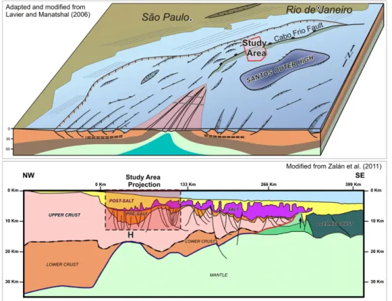
this feature northwards (Fig. 1). Towards the study area, a set of normal faults forms a less significant SW-NE-trending structural low. The continuity of all these regional structures outlines a region of fragile basement from the southern failed rift basin up to the proximal part of the study area (Fig. 1). The depression thus formed, which predated salt deposition, later acted as a controlling depo-center for the main Late Cretaceous progradational wedge. This structural low is parallel to the Cabo Frio Fault suggesting a common structural control for both features (Fig. 1). Although available or published data is limited in the Santos Basin, we assume that the regional crustal thinning, including the failed rift branch, is similar to Lavier and Manatschal’s model (2006), involving an H block in front of a V-shaped basin (Fig. 4). According Lavier and Manatshal (2006)andPéron-Pinvidic and Manatschal (2010), the H-Block (Hanging wall) represents a relatively under-formed upper crust piece, thinner than 20 km, bounded by a con-tinentwards thinning fault and an oceanwards exhumation fault, with preserved pre-rift sediments cover. The authors highlight the H-block resembles a remarkable retardation of subsidence whose origin is not yet well understood.Péron-Pinvidic and Manatschal (2010) defined the ‘V’-shaped basins as representing schemati-cally the temporal and spatial evolution of different and consecu-tive phases of rifting, with associated crustal blocks formation. The crustal thinning, broadly distributed in the upper crust, is also probably reflected in the basin compartmentalization by shear zones (Zalán et al. 2009).
A significant structural high known as the“Outer High of the Santos Basin” (Gomes et al., 2002) or the “Santos External High” (Carminatti et al., 2008) is located slightly southeastward of the studied area. It corresponds to an important basement structure in the central part of the São Paulo Plateau where the marine sedi-mentary infill is relatively thin, around 1000 meters, when compared
to more proximal regions. As demonstrated by recent wells, Aptian carbonates were deposited on this wide basement high under shallow-water marine environment (Carminatti et al., 2008). The complexity of depositional paleoenvironments, shifting from restricted and shallow water to deep water beyond the Santos External High, made the understanding of this carbonate succession a tectonic and stratigraphic challenge. There is not much available data (paleo water depth, relief, among others) to constrain or cali-brate the paleoenvironmental restoration of these post-rift sequences.
2.3. Structural implications of the salt tectonics
The Santos Basin is the southernmost Atlantic basin where Late Aptian evaporites were deposited (Mohriak et al. 2008). Climatic conditions were favorable for salt deposition on the São Paulo Plateau and in other basins to the North. Those conditions were enhanced by the structural alignment of paleohighs such as the Florianópolis Platform and the São Paulo Ridge (Fig. 1). The struc-tural highs acted as efficient barriers at the southern limits of the basin blocking the marine water circulation derived from the proto-Atlantic Ocean (Leyden et al. 1976). A fast and short (ca. 0.5 Ma) regional subsidence pulse of over 1000 m occurred during the Late Aptian probably as a consequence of the isostasy induced by the thick salt layer deposition (prompted by the calculations fromVan Den Belt and De Boer 2007). Nevertheless, the existing tectonic barriers still blocked the entrance of the surrounding oceanic waters and kept the basin sufficiently closed to allow for salt deposition.
Evaporites canflow similarly to a viscous material geologically speaking when they are differentially loaded by overlying sedi-ments since the earliest depositional stages (Demercian, 1996). The salt motion occurred westward towards the Southeast, between the Cretaceous Santos hinge line and the salt pinch-out, close to the São Paulo Ridge (Fig. 1). The high accumulation rates since post-middle Cretaceous deformed the thick Aptian salt sequence resulting in a relatively shallow bathymetry over the São Paulo Plateau (Mohriak et al. 2008). During the drift phase, the salt and the overburden were intensely deformed in a convergent radial transport (Cobbold and Szatmari, 1991), and the deforma-tion increasingly varies from distension near the coast to compression in deep waters region (Fig. 3). The most active tectonic time was the Late Cretaceous, as a response to the load of progradational wedges over the thick salt layer (in the compart-ments C D E ofFig. 3).
The Cabo Frio Fault (Fig. 1 and 3) marks the major transition between the extensional and compressional salt tectonic domains (Mohriak and Szatmari, 2001). Beyond this fault, the classical min-ibasins behave passively within the compressional domain. The evolution of the Cabo Frio Fault is related to huge volumes of sedi-ments deposited since Albian times over the thick salt layer which provides the accommodation space. The progradation evolving from the shallow shelf towards the basin inflated even more the original salt thickness in deep waters creating a relative restriction for sedimentation (Ge et. al., 1997). The salt layer reacts to its proximal squeezing pushed by the overburden deposition, thus becoming locally exposed in reactive diapirs, inhibiting distal depocenters. Under such constraints, the shelf / slope / rise system evolves with proximal thick layering and pushes laterally the thin distal set in the footwall of the Cabo Frio Fault (Mohriak et al. 2008). The minibasins werefilled by minor sedimentaryflows bypassing the slope. These conditions changed at the end of the Late Creta-ceous progradational event, when the tectonic saltflow strongly decelerated and virtually ceased during the Cenozoic. Therefore, the minibasins became more significant, developping more extensive sandy bodies in less confined depocenters (Moreira et al. 2007).
Within the São Paulo Plateau, an impressive stratified salt column is located on the Santos External High (Freitas, 2006). This package is not autochthonous, as it has been laterally displaced above the basal detachment, controled by irregularities of the underlying basement relief. More rugged features observed on cross-section A-A’can be related to the preexisting structural framework (Fig. 3).
3. Methodology
The restoration procedure presented here comprises the following backwards successive steps: (1) sediment removal and decompaction with isostaticflexural compensation; (2) fault and salt movement restorationfitting the paleogeometry to a reference target; (3)final paleobathymetric adjustments. Compared with other restoration methods (e.g.Rowan, 1993), this one is a simplified approach, which simultaneously considersflexural isostatic compensation and vertical decompaction. In addition, it does not consider eustasy and litho-sphere cooling. The effects of these processes are compensated in the final paleobathymetric calibration. Fault-related and salt movement deformations are restored with traditional algorithms such as simple or inclined shear and move-on-fault, taking into account a conserva-tive cross-sectional area of the sedimentary layers, including the salt. The assumption of salt cross-sectional area preservation is limited only below its overburden and has no intention to be realistic. It is proposed to constrain the uncoupled restorationfitting (both pre-salt by faulting during rift phases and post-salt solely by salt tectonics), through the structural coherence of the salt deformation within a controlled amount (area) of salt. The model is constrained by a defined paleogeometry (shelf-slope-rise), subsequently adjusted using the constraints of the well biostratigraphic data. The restoration was performed using RECON-MS (Petrobras in-house developed software).
To better understand the structural restoration carried out here, the restoration cycles followed major sequences based on the stratigraphic groups proposed byMoreira et al. (2007)(Fig. 2). An exception is made for the Guaratiba Group, subdivided in two parts, considering the salt layer as an individual major sequence on account of its relevant tectonic role.
3.1. Backstripping withflexural isostatic compensation
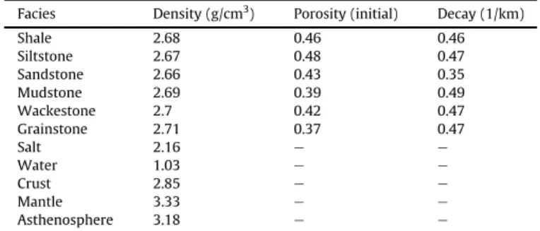
The backstripping approach shows that a significant part of the basin subsidence is due to sedimentary loading and the layering needs to be corrected throughout the time for the compaction effects. The decompaction solution applied here is based on Sclater and Christie (1980), similarly discussed in Bender et al. (1989). The decompaction of the underlying layers related to the removal of the uppermost sedimentary layer is calculated in vertical lines along the cross-sections. More regular and greater distance of discretization is applied to the flexural isostatic correction. Thus, the cross-sections are prepared in view of a detailed facies definition along the layering to improve these calculations. The parameters used in this procedure are listed in Table 1. The remaining decompacted units are referenced with respect to the base of the removed unit whose overall geometry is based on the isostatic compensation, calculated considering a constant lithospheric flexural rigidity for the entire cross-sections and during the entire geologic time.
as on the flexural rigidity of the lithosphere. The assumption of a constant elastic thickness through time and space is an acceptable simplification even though the lithospheric rigidity varies due to either its physical integrity or with the thermal regime (Watts, 2001). A lithospheric elastic thickness of 5 km is assumed (for a discussion on this value see, e.g.,Roberts et al., 1998; Tiley et al., 2003) and a crustal density of 2.78 g/cm3.
The loads of the sedimentary sequences along the Santos Basin (which extends over more than 400 km beyond the study area) are not entirely represented in the cross-sections A-A’and B-B’, each around 120 km long. Moreover, the post-salt sedimentary sequences become progressively shortened in the study area during the sequential uncoupled restoration, suggesting even shorter load lengths. The consequent underestimated unloading can produce inaccuracies in the isostatic calculations. In order to simulate a sedimentary load more similar to the totalflexural load and also to restore the missing sedimentary segments which have been pushed outside of the study area by halokinesis, the cross-sections are laterally extrapolated (Fig. 5). The isostatic approach provides a paleobathymetric estimation which requires additional calibration at the end tofit the real equilibrium.
Erosional features are noticed in both cross-sections: in the proximal and slope regions, linked to sea level changes and close to salt diapirs. Although unconformities are crucial for the regional stratigraphy (Fig. 2), the erosions have no great magnitude and are not taken into consideration in the restoration. The impact that these erosions would cause is certainly smaller than the uncer-tainties involved in the salt movement restoration.
3.2. Structural block restoration
Several algorithms were applied to restore the deformed geometry of each cross-section. Length, cross-sectional area, or both, can be retained for the restored layers, depending on each algorithm. Therefore, neither gain nor loss of material is significant to the resulting geological features over time. We have sought the simplest methods to obtain restoration solutions. Considering dominant ductile deformation for the salt layer and brittle defor-mation for other sedimentary layers, each cross-section has been subdivided into minor individual blocks with similar rheology, whenever necessary at each restoration cycle. These blocks are limited by well defined geological elements, such as stratigraphic contacts, salt diapir boundaries, seafloor or normal faults. Each block is restored by geometrical transformations to a target geometry, constrained by the paleobathymetry and by lateral block boundaries (faults, diapirs or cross-section borders).
Simple shear transformation is able to preserve the blocks’ cross-sectional area in 2D restoration. These shear transformations have been used to restore brittle blocks in the extensional defor-mation domain and also in less deformed situations of the distal domain. Flexural unfolding transformations preserving length on the layering shortening direction have been rarely used to restore the folding of deep layering in some minibasins blocks. Consid-ering major deformation concentrated close to the faults and diapirs edges, sometimes partial restoration steps were super-imposed, increasing shear restoration amount to better restore some intensely deformed salt-sediment boundaries. Sometimes
Figure 5.The cross-section B-B’is laterally extrapolated based on the regional transect X-Y-Z fromCarminatti et al. (2008). The thick evaporites in the southeastern extrapolation are very important to the study area restoration once their deformation provided the accommodation space for the prograding sedimentary pile.
Table 1
Facies parameters applied to decompaction andflexural isostatic compensation. Salt is considered non-compressible, without variations during the decompaction calculations.
Facies Density (g/cm3) Porosity (initial) Decay (1/km)
Shale 2.68 0.46 0.46
Siltstone 2.67 0.48 0.47 Sandstone 2.66 0.43 0.35 Mudstone 2.69 0.39 0.49 Wackestone 2.7 0.42 0.47 Grainstone 2.71 0.37 0.47
Salt 2.16 e e
Water 1.03 e e
Crust 2.85 e e
Mantle 3.33 e e
part of the salt diapir was included in the block to smooth the rugged fault or diapir geometries.
In contrast with other brittle sedimentary rocks, the ductile rheology of the salt layer was treated by free adjustment to other restored blocks. As described before, the salt cross-sectional area is retained only under the restored overburden and this limitation provides a degree of freedom to keep structural coherence. The salt geometry is modified on the differential gap left by the uncoupled restoration. The salt area along with its respective overburden should be recomposed in the remainder cross-section. This lateral redesign is an artifact related to the differential shortening of the uncoupled restored post-salt packages over the almost untouched pre-salt packages. The gap isfilled with the addition of segments as explained before (Fig. 5).
3.3. Paleobathymetric referential geometry
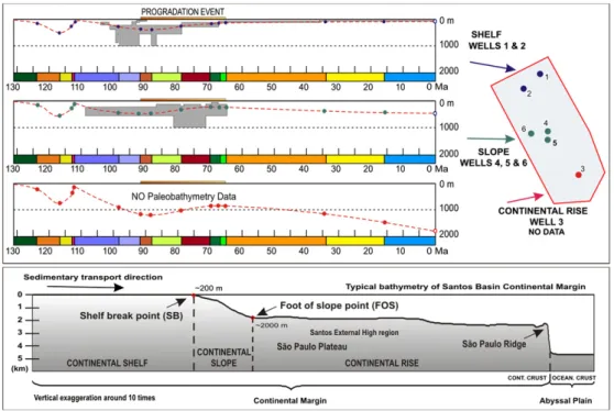
The decompaction procedure tries to strike an isostatic balance as thefirst paleobathymetric approximation for the backstripping calculations. After the structural block modifications, the 2D resto-ration approach requires paleobathymetric profiles at each incre-mental step to which the basin subsidence should be adjusted. The uncertainties in the bathymetry model based on the well data are represented by ranges of water depths and of time intervals (Fig. 6). The Santos Basin is characterized by a wide and shallow conti-nental margin spreading over 700 km offshore, with gradual decrease of the post-salt package towards distal portions in the São Paulo Plateau (Fig. 5). Seismic interpretation data allows tracking changes in the shelf - slope - rise system, by progradation, aggradation or regression. These observations suggest that the progradation was controled by structural highs in the distal region.
The shelf / slope / rise limits can be recognized by their geometric characteristics described as following. The continental shelf, usually limited to 200 m water depth (Pinet, 1996), is exceptionally wide (in the order of 200 km) in the Santos Basin. The shelf break point is
easy to pick on the seismic sections for the different post-salt interpreted horizons. Beyond the shelf break, the continental slope is characterized by thickness variations and, consequently, also by changing gradients. The transition to the continental rise is marked by another gradient change at the foot of the continental slope. The lower bathymetric gradient is also followed by the decrease in the average thickness of sedimentary packages in the region of the continental rise, as observed by Carminatti et. al. (2008). In the Santos Basin, the outer boundary of this domain to the abyssal plain is marked by the abrupt topographic offset of the São Paulo Ridge.
The shelf break and the slope edge were identified for each interpreted horizon on the 2D seismic data in the study area (Fig. 7), as well as their general paleolocation through time. These points provide key references for the shelf / slope / rise target geometry during the blocks restoration. The slope edge is always located in the hanging-wall of the Cabo Frio Fault in the study area. Thefinal geometry is ultimately calibrated using the available paleoenvir-onmental data from wells.
Each decompacted block is individually restored tofit the target geometry respecting the shelf break and the slope edge postulated positions. Some difficulties arise from adjusting the isostatically decompacted layers to this target geometry. They need to be accommodated through the salt layer restoration and by the isostatic adjustments in the brittle pre-salt set. It is important to remember that both thermal subsidence and eustatic processes are not considered in the calculations, but they are compensated during the paleobathymetric calibration.
3.4. Structural consistency
The most important criterion for the restoration is structural consistency. The structural evolution since salt deposition to present time results from gravity spreading and progradation above a thick and ductile salt layer. The extensional structures occur in the
proximal parts of the cross-sections, i.e., on the shelf and upper slope domains. Compressional gravity-driven structures and minibasins are restricted beyond the slope edge, where relatively thinner post-salt layers are deposited. During gravity spreading, the thick post-salt layer gradually becomes more deformed. Once this layer is locally depleted or welded, either in the footwall of the growth faults or in the compressional domain below minibasins, both the overburden and salt thicknesses must be consistent with the paleobathymetry. This must be checked in every restored cycle.
Erosive features are observed on the slope domain. Such features represent restriction for accommodation space or sediment bypass along the slope. The slope domain in these situations is positioned over a regional basement high and shows a shortened width. Restrictions to the saltflow and also to the salt thickness variation are expected. On the other hand, where a thicker layer is deposited after salt withdrawal, either due to local collapse or gravity slide, this shift must also be consistent with the paleobathymetry in the salt layer restoration.
If salt thickness variation is required through time, certain features should be avoided, i.e. the successive random formation and
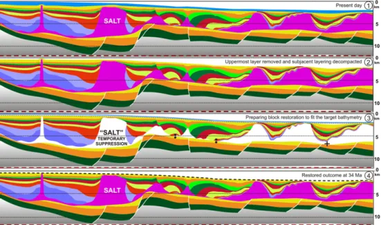
destruction of salt welds, as well as random increase and decrease in salt thickness. In all these situations, the local subsidence rates applied to brittle layers and deformation rates of the underlying ductile salt layer should be consistent with the paleobathymetry profile.Figure 8shows a detailed restoration of the applied meth-odology. This example of the structural restoration steps includes:
I) The initial (present day) condition of cross-section A-A’; II) The decompaction of the youngest layer andflexural isostatic
compensation;
III) First paleobathymetric approximation, calculated according to the decompaction procedure. The blue line represents the regional bathymetry used as target. The salt layer is suppressed to allow the best block restoration adjustment to the decou-pled post-salt package. Small circles show two salt welds that should be preserved, whereas a small cross indicates a salt thickness to be maintained;
IV) Post-salt package adjusted to the top target line, seeking the best replacement of the initial amount of salt below the package. This step leads to a complete restoration cycle. Figure 7.The shelf break (white points) and foot of the slope (black points) are shown here for the cross-section B-B’. These critical points have been interpreted for each restored horizon above the salt layer, including the Albian carbonates top (H9). Notice the Cabo Frio Fault which limits the thicker proximal domain from the post-salt minibasins that developed in the more distal domain.
4. Restoration and discussion
Outcomes of fourteen different restoration restoration cycles are presented. These results represent the geological evolution for fifteen horizons interpreted in cross-sections A-A’ and B-B’. The pre-salt sequence is thefirst offive major sequences considered in the structural evolution. The last three restoration outcomes (Fig. 9) are related to deformation of this sequence when brittle tectonics was prevalent. Strongly different, the following eleven restoration outcomes (Figs. 10, 11, 13 and 14) record the effects of thermal subsidence and ductile salt deformation. The subdivision of the
post-salt sequences can be explained by the major factors controlling salt tectonics: the preexisting relief at the time of salt deposition and the sedimentation rate. These factors provide different conditions for the gravitational deformation as, for instance, changing in the thickness relations between the ductile salt layer and the brittle overburden through time. These various aspects of salt tectonics have been already well discussed by several authors (e.g.,Cobbold and Szatmari, 1991; Weijermars et al., 1993; Lerche and Petersen, 1995; Garcia, 1999; Mohriak and Szatmari, 2001; Hudec et al., 2009).
Thefive sequences are described below.
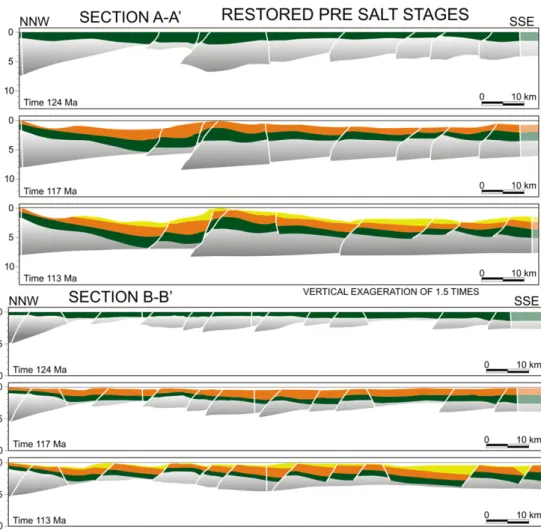
Figure 9.Restoration outcomes of pre-salt stages applied without paleobathymetric data to cross-sections A-A’and B-B’. Notice the extension restored represent less than 10% from the deformed cross-section. The resulting topography reaching up 3000 meters of depression in the cross-section A-A’is consistent with the accommodation space needed for the thick salt layer deposition.
4.1. Pre-salt sequence
The quality of the subsalt seismic imaging is not good enough to solve uncertainties related to the pre-salt layers. In general, the tilted blocks involving the basement and syn-rift strata beneath the base of the salt were defined only by a few faults without good definition of the dip of the pre-salt series (Fig. 9). The unconformities subdividing this sequence are not easily mapped and, moreover, no data about the target relief of these sequences is available. The restoration of these sequences characterized by a graben- and horst-dominated fault system was marked by block rotation and significant exten-sion is observed in the proximal basement low domain (Figs. 3 and
5). This feature is consistent with the hypothesis of a northward lateral prolongation of the brittle normal structures farther south into the failed spreading centre (Figs. 1, 4 and 5). This structural low had presumably already been formed before the time of salt depo-sition (Fig. 9). The restored geometry at the pre-salt sequence top suggests that significant topography existed in the basin prior to salt deposition. However, the lack of paleobathymetric data prevents any accurate calibration and therefore, this geometry remains quite speculative, resulting only from the isostatic and structural adjust-ments applied during the restoration. The present-day architecture derived from the interpretation of seismic images is the most deformed situation of the pre-salt layers. Thus, the pre-Aptian basement architecture is assumed here to have been less deformed in the past.
4.2. The Aptian salt sequence
The salt layer is progressively pushed towards the distal regions of the basin due to gravitational instabilities (Fig. 10). The light pink segment of the salt layer represents the recovered amount resulting from its restored movement from present day to deposition time. The dark pink segment has a cross-sectional area equal to the present day cross-section. In the study area, the salt layer presents different average thicknesses in each cross-section: it is around 1600 m-thick in cross-section A-A’and about only 700 m-thick in cross-section B-B’(Fig. 3). The restored salt layer is more homogeneous and is on average around 2800 m-thick in cross-section A-A’and about 1200 m-thick in cross-section B-B’ (Fig. 10). The thickness differences consider both segments of the salt layer.
During the restoration of the halokinesis shortening, virtual gaps rest over the position from where large amount of salt was pushed outside the study area. When we regard this salt amount as replacing the lateral gaps (light pink segment), the isostatic response of the pushed salt prevents minor deformation due to the salt loading absence. The loading replacement applied throughout the entire restoration workflow leads to a better shape for the Figure 11.Restored profiles of cross-sections A-A’and B-B’for the Albian to Cenomanian stages that shows a climax of the rafting tectonics in the Santos Basin. The fast extension of the thin Albo-Cenomanian layers is obtained by the underlying salt layer movement, pushed to distal portions by the thick post-salt sediments deposition in the proximal area.
initial basement geometries in both cross-sections, with cumula-tive isostatic effects through time. No attempt was made to restore the top of the restored salt layer at its deposition time, and a sub-horizontal bathymetric gradient (<1%) was assumed. The restora-tion was not applied to the region of the added segments (light pink salt). A thick regular salt layer was added to provide the loading effects, without any bathymetric adjustment. It is impossible to interpret any structural feature at salt deposition time, before the sedimentation of the overburden units, based exclusively on low resolution data.
4.3. Albian to Cenomanian sequences
domain, a large salt volume covered by a thin overburden favors a fast gravitational gliding. Different sedimentation domains and paleoenvironments were linked with the shelf / slope / rise geometries.
The thickness variations interpreted in the seismic data for the Albian and Cenomanian layers show a thick proximal portion developed in continental shelf and slope domains. An underlying thick salt layer provides the initial minimum basin amplitude to accommodate the carbonate shelf development. Thin and folded distal Albian carbonate layer interpreted as continental rise deposits are clearly restored in their initial unfolded stage and reconnected at their correct paleobathymetric position (Fig. 11 and 12). In the following sequences, before the development of the classical mini-basins, these carbonates were translated basinward by raft tectonics. Thickness variations in the Albian sequence are observed on seismic lines (Fig. 3) and allow to interpret a sedimentary growing that represents the beginning of the halokinesis process. Restoration results corroborate the relationship between progradation and the squeezing of the salt basinwards. The development of the Cabo Frio fault during the Albian to Cenomanian sequences (Fig. 11) is sug-gested in the transition from the thicker proximal overburden to the thinner distal one.
4.4. Late Cretaceous progradation sequences
During the massive progradation of the Late Cretaceous sedi-ments, the salt movement accommodated the development of multiple overburden blocks limited by faults or salt structures
(Fig. 13). In early evolution of these sequences, the proximal area is characterized by a thicker post-salt package, already compartmented by diapirs. Structural and thickness differences are observed among these Late Cretaceous restored geometries in both cross-sections. Such differences are important for the progradation evolution in the hanging wall of the Cabo Frio Fault. There was a general tendency to develop antithetic faults close to the slope edge, while the slope advanced as a consequence of progradation. This tendency seems to be related to differences between the thick continental shelf and the thin continental rise overburden domains, controling the Cabo Frio Fault since its onset. A significant basinwards retreat of the Cabo Frio footwall is restored and little or no fault gap will remain to be restored in subsequent phases. With the progradation development, the largest depocenters are formed beyond the continental shelf. This shift in sedimentation pattern is described byAssine et al. (2008). The sedimentation was probably controled by a bypass through the thick continental shelf overburden, which was relatively blocked against the structural high, causing adjustments in the Cabo Frio Fault geometry. Thefirst salt welds are formed beneath thick post-salt depocenters.
4.5. Cenozoic sequences
progradation observed byGe et. al. (1997)no longer inhibites distal sedimentation in the minibasins. The coeval large extensional deformation with large horizontal displacements observed by Mohriak et. al. (1995)during the evolution of the Cabo Frio Fault has also ceased.
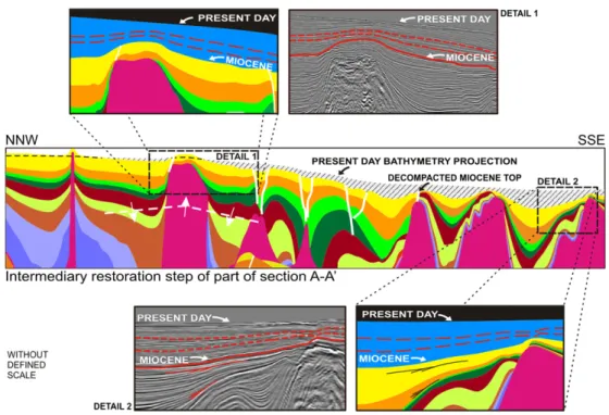
If the aggradational pattern is associated with a more uniform subsidence, the continued salt movement turns out to be more localized as illustrated by the isostatic response of the most recent layer removal (Fig. 15). There is no much accommodation space near the slope domain, particularly due to growing salt structures that control local thickness variation of the overburden (Fig. 15, detail 1). With the removal of the uppermost layer, a suggestive folding corroborates the salt activity in the slope domain. Ongoing salt activity at the borders of the minibasins causes the growth folding with associated uplift and erosion of the adjacentflanks (Fig. 15, detail 2).
4.6. Bathymetry and isostasy
Bathymetry and isostasy have a strong correlation within the restoration procedure. A bathymetry model is applied as an upper boundary condition while isostasy is applied as lower boundary conditions to the sedimentary layers below the salt.
The bathymetry model applied to every post-Aptian restoration cycle proposes target geometries with low resolution, according to the available data (Fig. 6). In the deeper portions and for several restoration cycles that do not have available data, the bathymetric model was freely extrapolated.
Calculations for theflexural isostatic compensation consider the entire loads applied to the lithosphere by the basin infill. Comparing isostatic results using elastic thickness values of 20 km and 5 km for the same single restoration cycle, gentle differential undulations with amplitudes of up to 50 meters high are in phase with major upper adjustments required to restore the cross-sections. The heterogene-ities of diapirs, minibasins and growth faults with a wavelength of
a few tens of kilometers would not cause any noticeable differential isostatic response at the scale of the restored cross-sections once applied the strongest rigidity. The observed difference corroborated the arbitrary choice of an elastic thickness of 5km.
The obtained isostatic response observed in restoration cycles comprised between Eocene to Recent times (Figs. 14 and 15) provide further constraints to the following restoration proce-dures. The greater the uncertainties to restore other sequences from the past, even if the salt tectonics is more intense, the more freedom they offer to adjust the restored paleobathymetric model.
No isostatic compensation is calculated for the blocks trans-lation performed during the structural restoration and for the salt replacement in voids produced by this translation. An example of that can be seen in the cross-section B-B ’(Fig. 11). The basal geometry of the Cenomanian outcome show the isostatic response related to the removal of the Frade Group bottom layer which is visible in the previous outcome, at 88 Ma (Fig. 13). A thick salt layer is redrawn to recompose the void left by the removed layer, near the Cabo Frio Fault position (Fig. 11). The new salt geometry represents a loading not accounted for isostatic effects, overestimating the isostasy for the case. The greater the stratigraphic detail in several thin layers, the smaller the defor-mation to restore in each cycle. A less abrupt salt movement to restore could minimize the isostatic effects of mass translation.
For the older units, deformed under an extensional regime, there is no paleoenvironmental data for calibration. The irregular topography presented in outcomes is produced solely by the restored tilted blocks with no subsequent adjustments.
A critical moment was found at the time of deposition of the evaporites. The strong isostatic effect produced by the removal of the thick salt layer predicts a preexisting accommodation space, not invaded by oceanic waters.
In the proposed sedimentation model, fast and continuous salt depositionfills a basin depression at 113 Ma (Fig. 9). A similar basin
geometry model for salt deposition is discussed byMontaron and Tapponier (2010). The isostatic effect is obvious in the 1D subsi-dence geohistory graphics discussed later.
4.7. Structural restoration style
The analysis of the variations in salt thickness and amount helps understand the structural coherency and different style of the salt layer deformation as well the overall restoration results in the study area. Intense salt deformation begins in a salt layer with more homogeneous thickness. The saltflowing out in each cross-section is not proportional to the salt existing at present day. According to the restoration results, the total amount of salt that occurs in both cross-sections is uneven, 1.6 times greater in the cross-section A-A’than in the cross-section B-B’at the beginning, for the Aptian restored stage (Fig. 10) and 2.4 times greater at the present day (Fig. 3). Comparing the same ages, the average thickness changes more than 4 times in the B-B’section, as opposed to less than 3 times in the cross-section A-A’. In other words, wherever there is less salt at the present day (cross-section B-B’), not only there was relatively more in the past but also the salt movement was greater through time. These hypotheses suggest that the distribution of salt was spatially more homogeneous in the past. The salt layer was more efficiently pushed away in the B B’cross-section, which is also consistent with the less fragmented deformation style observed in the orverburden of this cross-section.
The decoupled restoration solution assumes diachronism between the salt gravity-driven deformation and the older tectonism affecting layers below the salt. The salt layer acts as a detachment layer for the gravity-driven deformation above this rheological limit. For the package deformed by salt tectonics, the cumulative extension represents an increase of nearly 60% in the study area. The cumulative extension for the brittle pre-salt domain represents an increase of only approximately 6%. The fault extension indicating negligible upper crustal stretching while large beta stretching factors do not restore completely the paleobathymetric indicators (Scotchman et. al., 2006). Depth-dependent lithosphere thinning, in which stretch-ing of the lower crust and lithosphere mantle greatly exceeds that of the upper crust, has been observed at many non-volcanic and volcanic rifted continental margins including conjugate margin pairs (Kusznir and Karner, 2007). The restoration results for the brittle deformation domain below the salt layer are consistent with the assumption ofMoreira et al. (2007). For these authors, the main faults of the rift phase ceased their activities or underwent rare reactivation after the deposition of Barra Velha Formation (Fig. 2) and this deformation, almost totally produced before the salt deposition, was fully restored during the restoration cycles of the rifting phase.
4.8. Geohistory based on 1D modeling
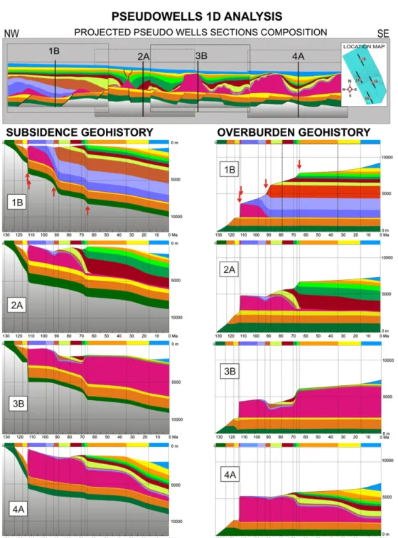
The 1D subsidence histories allow simple and useful evolutionary analysis. It is possible to give new uses to the 1D geohistory inte-grating them with the 2D restoration results. The classical 2D and 3D basin modeling simulations are, usually, constrained under struc-tured meshes. In such simulations and many previous 1D studies, phenomena related to salt deformation are solved by the simple salt thickness variation. The spatial deformation of the structures can be explored. A pseudo-well can be extracted from the intersection points of a vertical line with all horizons at afixed position in the present day cross-sections. A historical component of each repre-sentative age can be extracted in the same vertical position from all remaining restored outcomes. In terms of the traditional basin modeling, the lateral tectonic transport due to the halokinesis affects most significantly the petroleum system mainly under minibasins, moving at the period of greatest activity of the Cabo Frio Fault,
between 92 and 70 Ma (Figs. 9 and 10). A geohistorical graph replacing all components through time illustrates how the over-burden, spreading to downstream situations, is progressively replaced at each age by the moving upstream overburden. For instance, thefirst overburden deposited above afictional point in Albian times has moved away, being now replaced by another Albian segment which was deposited farther north-northwest. This can be easily observed, for example, in afictional point in the middle of the cross-sections at the initial andfinal restored geometries of the Late Cretaceous progradation (arrows and dashed lines in theFig. 13).
Built from restored cross-sections results, the 1D subsidence and overburden historical graphs (Fig. 16) replace the traditional image of layers only under increasing compaction by layers with tectonic movement. The added value of this approach for the analysis of thermal effects depends on the magnitude and timing of the lateral movement that the system has suffered. The difference may be significant for situations with greater lateral movements if, for instance, the thermal data from deeper burial (less thick salt layer) is moved to replace a pushed overburden that is relatively colder (thicker salt layer), overlying a petroleum source rock kitchen (with a structurally modified geothermal history), similar to the geohistory of the pseudo-well 3B (Fig. 16). Apart from this context, the halokinesis deformation should not significantly affect the petroleum system, since the source rocks (underlying the salt layer) and salt welds (i.e. potential migration windows) remain relatively static through time. The results suggest variable strain rates for salt tectonics in the Santos Basin, supporting the assess-ment ofAraújo et al. (2005)that the major part of the salt defor-mation occurs until the end of Cretaceous, with minor movements afterwards. Even if local kitchens might be mature early, these authors consider the peak of oil expulsion at the Late Campanian, with significant migration pulse from 44 Ma to the present day. In other words, during the entire Paleogene several elements of the petroleum systems remain almost in the same vertical position as they are today.
The 1D historical graphs are also useful as consistency control tool for several restoration parameters such as bathymetry, isostasy and salt thickness variation. Some abrupt changes in isostasy and paleobathymetry can be observed through few 1D restored schemes and seem to stand out as boundaries for thefive major sequences (red arrows in Fig. 16). The general bathymetric model (Fig. 6) illustrates the critical isostatic adjustment at salt deposition time passing from a major, deep and dry continental depression to a shallower environment. The prograding wedge in the Late Creta-ceous reverses the deepening bathymetric evolution, advancing the shelf break basinwards. The tectonic-sedimentary control is imposed on the consistent 1D graphs.
Such graphs represent a quality control for the restoration process by crossing the one-dimensional evolution against the cross-sections constraints imposed by the workflow. This simultaneous check helps identify critical points, hence improving the restoration results.
5. Conclusions
The approach of integrating structural restoration tools with isostatic control and paleobathymetric model is crucial to obtain reliable results. A relatively simple 2D workflow based on classical backwards cyclic steps was carried out in this work: (1) isostatic flexural response to unloading and decompaction; (2) fault-related block restoration to fit a paleobathymetric model to the few
available wells and seismic data; and (3) adjustments in the salt layer under volume conservation, integrating the paleobathymetric and isostatic results. The 2D restoration is revisited through 1D comple-mentary analysis, which can also be used as a calibration tool. The calibration workflow intends to make all restoration stages more integrated through time and space. The workflow could also be suitably applied in other basins and/or complex situations, for instance, where erosive features are important.
Afterwards, the structural high worked as a bulkhead during the salt deformation.
For the post-salt layers deformed by halokinesis, the brittle clastic package developed early in the proximal domains, in contrast with the thin sequences of the distal regions, shaped by the ductile rheology of the thick salt layer. These thin sequences either behaved as small rafts during early extension or developed a subsequent and continuous shortening in the minibasins area. A constant salt cross-sectional area assumption through time is not a realistic constraint in the study area. A first approximation is related to the 2D nature of the restoration while salt movements occur in a complex 3D space. Moreover, segments with additional cross-sectional salt area are brought from distal areas, consistent with the large volume of salt, known beyond the study area. This approach provides a good scenario of restoration for the two geological cross-sections presented in this paper. Geometric pale-oenvironmental model, paleobathymetric data and flexural isos-tasy calculations provide guidelines to restore independent packages above and below the ductile salt layer. Constant, low elastic thickness assumed in the restoration processes does not cause major problems to the methodology approach. On the other hand, the uncertainties in the restoring transformations reflect the lower resolution data and established constraints. The results are robust and offer opportunities for corrections and improvements both in the restoration tool and the workflow.
Geohistory 1D analysis based on 2D cross-section restoration results are complementary tools which improve the whole 2D pal-inspastic process. Inconsistencies produced during restoration steps can be easily observed in these graphs and used again as a new input for further optimization loops. The 1D graphs allow for a consistent evaluation of the local bathymetric variation through time. The 1D subsidence graphs confirm that the sedimentary evolution in the study area results from a continuous sedimentary progradation. They illustrate salt thinning first in the proximal portions and, then, gradually occurring in the most distal areas. They also provide a different approach from the traditional basin modelling based on the lateral movement of the sedimentary segments for 1D thermal modeling. The lateral tectonic transport due to the halokinesis impacts the traditional basin modeling, in the regions of the Santos Basin with greater movement of minibasins.
The approach presented here, integrating a simple 1D tool, along with several constraints applied to multiple 2D structural restora-tion, provide opportunities for analysis of the salt deformation complexity in time and space.
Acknowledgments
Fist of all, we would like to thank Petrobras for all support during the present research. We also express our gratitude to Sylvia Anjos, François Roure, Henrique Penteado, Cláudia Lima, Gilvan Hampsi and Pedro Zálan who made important contributions to this paper. Our thanks to the Petrobras E&P petroleum systems geologists, the IFP Energies Nouvelles researchers and the Tecgraf IT support team. This paper would not have beenfinalized without their support, comments and suggestions.
References
Almeida, F.F.M., 1976. The system of continental rift bordering the Santos Basin, Brazil. Anais da Academia Brasileira de Ciências 48 (suppl.), 15e26.
Arai, M., 1988. Geochemical reconnaissance of the Mid-Cretaceous anoxic event in the Santos Basin, Brazil. Revista Brasileira de Geociências 18, 273e282.
Araujo, L.M., Garcia, S.F.M., Queiroz, C.L., Cortez, M.M.M., Saito, M., 2005. A 4-D Petroleum System Model in a southern area in the Santos Basin, Brazil, In 4th ALAGO Workshop Basin Modeling, Buenos Aires. CD-ROM Abstracts, 3 pp. Assine, M.L., Correa, F.S., Chang, H.K., 2008. Migration depocenters in the Santos
Basin: importance for hydrocarbon exploration. ((Migração de depocentros na
Bacia de Santos: importância na exploração de hidrocarbonetos)). Revista Brasileira de Geociências 28 (suppl. 2), 111e127.
Bender, A.A., Mello, U.T., Chang, H.K., 1989. Bidimensional reconstitution of the geologic history of sedimentary basins: theory and its application in the Campos Basin. ((Reconstituição bidimensional da história geológica de bacias sedimentares: teoria e uma aplicação na bacia de Campos)). Boletim de Geo-ciências da Petrobras 3 (1/2), 67e85.
Braga, L.F.S., Costa, C.M., Gama, F., Fontoura, C., Cunha, A.S., Dourado, F., Correa, F.S., 2003. Magneto-Structural Imaging (MSI) and regional basement of the Santos Basin, Brazil. In: SBGf. International Congress of The Brazilian Geophysical Society, 8. CD-ROM, Rio de Janeiro, p. 4.
Cande, S.C., Rabinowitz, P.D., 1978. Mesozoic seafloor spreading bordering conjugate continental margins of Angola and Brazil. In: Proceedings of Offshore Tech-nology Conference, 10, pp. 1869e1871. Houston, Texas, OTC3268.
Carminatti, M., Wolff, B., Gamboa, L.A.P., 2008. New exploratory frontiers in Brazil. In: World Petroleum Congress, 19. Madrid, Spain, WPC proceedings, 11 f. Cobbold, P.R., Meisling, K.E., Mount, V.S., 2001. Reativation of an obliquely rifted
margin, Campos and Santos Basin, Southeastern Brazil. American Association of Petroleum Geologists BulIetin 85 (11), 1925e1944.
Cobbold, P.R., Szatmari, P., 1991. Radial gravitational gliding on passive margins. Tectonophysics 188, 249e289.
Demercian, L.S., 1996. Halokinesis in evolution of the south of Santos Basin from the Aptian to Upper Cretaceous (A halocinese na evolução do sul da Bacia de Santos do Aptiano ao Cretáceo superior). Master Dissertation, Universidade Federal do Rio Grande do Sul, Porto Alegre, Brazil.
Dias, J.L., 1998. Stratigraphic and sedimentological analysis of Aptian stage in part of the eastern margin of Brazil and Malvinas Plateau: considerations about the
first marine incursions and ingressions of the South Atlantic Ocean (Análise sedimentológica e estratigráfica do andar aptiano em parte da margem leste do Brasil e no Platô das Malvinas: considerações sobre as primeiras incursões e ingressões marinhas do Oceano Atlântico Sul Meridional). PhD thesis, Universidade Federal do Rio Grande do Sul, Porto Alegre, Brazil.
Freitas, J.T.R., 2006. Evaporite depositional cycles of the Santos Basin: an analysis of cyclostratigraphy data from two wells and seismic traces (Ciclos deposicionais evaporíticos da Bacia de Santos: uma análise cicloestratigráfica a partir de dados de 2 poços e de traços de sísmica). PhD thesis, Universidade Federal do Rio Grande do Sul, Porto Alegre, Brazil.
Garcia, S.F.M., 1999. Three-dimensional study of effects of halokinesis in passive margins (Estudo tridimensional de efeitos da halocinese em margens passivas). Master Dissertation, Universidade Federal de Ouro Preto, Brazil.
Ge, H., Jackson, M.P.A., Vendeville, B.C., 1997. Kinematics and dynamics of salt tectonics driven by progradation. American Association of Petroleum Geologists Bulletin 81 (3), 398e423.
Gomes, P.O., Kilsdonk, B., Minken, J., Grow, T., Barragan, R., 2009. The Outer High of the Santos Basin, southern São Paulo Plateau, Brazil: pre-salt exploration outbreak, paleogeographic setting, and evolution of the syn-rift structures. Available in:
http://www.searchanddiscovery.net/documents/2009/10193gomes/index.htm. Accessed on 11/20/2011.
Gomes, P.O., Parry, J., Martins, W., 2002. The Outer High of the Santos Basin, southern São Paulo Plateau, Brazil: Tectonic. In: American Association Petro-leum Geologists, Hedberg Conference, Hydrocarbon habitat of volcanic rifted passive margins, pp. 8e11. Stavanger, Norway.
Guerra, M.C.M., 2008. Role of halokinesis in controlling structural styles and sedi-ment dispersal pattern in the Santos Basin, offshore SE Brazil. PhD thesis, University of Edinburgh, UK, 270 p.
Guimarães, P.P., Almeida, H.P., Kowsman, R.O., Costa, M.P., Boa Hora, M.P., 1982. Gravimetric modelling in São Paulo Plateau southern portion and its geological implications. ((Modelagem gravimétrica na porção sul do Platô de São Paulo e suas implicações geológicas)). In: Sociedade Brasileira de Geologia, Brazilian Geological Congress, 4, pp. 1570e1575. 32, Salvador, Bahia.
Hudec, M.R., Jackson, M.P.A., Schultz-Ela, D.D., 2009. The paradox of minibasin subsidence into salt: clues to the evolution of crustal basins. Geological Society of America Bulletin 121, 201e221.
Karner, G.D., Gamboa, L.P.A., 2007. Timing and origin of the South Atlantic pre-salt sag basins and their copping evaporites. In: Schreiber,, B., Lugli,, S., Babel,, M. (Eds.), Evaporites through space and time. Geological Society, London, pp. 15e35.
Special Publication, 285.
Kumar, N., Gamboa, L.A.P., Scheiber, B.C., Mascle, J., 1977. Geologic history and origin of São Paulo Plateau (southeastern Brazilian margin), comparison with the Angolan margin, and early evolution of the northern South Atlantic. In: Supko, P.R., Perch-Nielsen, K. (Eds.), 1977. Initial reports of the Deep Sea Drilling Project, 39, pp. 927e945. Washington, D.C.
Kusznir, N.J., Karner, G.D., 2007. Continental lithospheric thinning and breakup in response to upwelling divergent mantleflow: application to the Woodlark, Newfoundland and Iberia margins. In: Karner, G.D., Manatschal, G., Pinheiro, L.M. (Eds.), Imaging, mapping and modelling continental lithosphere extension and breakup. Geological Society, London, pp. 389e419. Special
Publications, 282.
Lavier, L.L., Manatshal, G., 2006. A mechanism to thin the continental lithosphere at magma-poor margins. Nature 440, 324e328.
Lerche, I., Petersen, K., 1995. Salt and sediments dynamics. CRC Press, Boca Raton, Florida.
Mascle, J.R., Renard, V., 1976. The marginal Sao Paulo Plateau, comparison with the southern Angolan margin. Anais da Academia Brasileira de Ciências 48, 179e190.
Meisling, K.E., Cobbold, P.R., Mount, V.S., 2001. Segmentation of an obliquely rifted margin, Campos and Santos basins, southeastern Brazil. American Association of Petroleum Geologists Bulletin 85, 1903e1924.
Mohriak, W.U., 2001. Salt tectonics, volcanic centers, fracture zones and their relationship with the origin and evolution of the South Atlantic Ocean: geophysical evidence in the Brazilian and West African margins, in: SBGf, International Congress of The Brazilian Geophysical Society, 7, Salvador, Brazil, Expanded Abstract, pp. 1594.
Mohriak, W.U., Macedo, J.M., Castellani, R.T., Rangel, H.D., Barros, A.Z.N., Latgé, M.A.L., Ricci, J.A., Mizusaki, A.M.P., Szatmari, P., Demercian, L.S., Rizzo, J.G., Aires, J.R., 1995. Salt tectonics and structural styles in the deep water province of the Cabo Frio region, Rio de Janeiro, Brazil. In: Jackson, M.P.A., Roberts, D.G., Snelson, S. (Eds.), Salt tectonics: a global perspective. American Association of Petroleum Geologists, pp. 273e304. Memoir 65.
Mohriak, W.U., Nemcok, M., Enciso, G., 2008. South Atlantic divergent margin evolution: rift-border uplifts and salt tectonics in the basins of SE Brazil. In: Pankhurst, R.J., Trouw, R.A.J., Brito Neves, B.B., De Wit, M.J. (Eds.), West Gond-wana: Pre-Cenozoic correlations across the South Atlantic Region. Geological Society, London, pp. 365e398. Special Publications, 294.
Mohriak, W.U., Szatmari, P., 2001. Salt tectonics and sedimentation along Atlantic margins: insights from seismic interpretation and physical models. Geological Society of America Memoirs 193, 131e151.
Montaron, B., Tapponier, P., 2010. A quantitative model for salt deposition in actively spreading basins. Available in:http://www.searchanddiscovery.com/ documents/2010/30117montaron/ndx_montaron.pdf. Accessed on 11/20/ 2011.
Moreira, J.P., Madeira, C.V., Gil, J.A., Machado, M.A.P., 2007. Santos Basin (bacia de Santos), in: Stratigraphic charts (Cartas estratigráficas). Boletim de Geociências da Petrobras 15 (2), 531e549.
Pereira, M.J., Macedo, J.M., 1990. Santos Basin: perspectives of a new petroleum province in the Southeastern Brazilian continental platform (A Bacia de Santos: perspectivas de uma nova província petrolífera na plataforma continental sudeste brasileira). Boletim de Geociências da Petrobras 4, 3e11.
Péron-Pinvidic, G., Manatschal, G., 2010. From microcontinents to extensional allochthons: witnesses of how continents rift and beak apart? Petroleum Geoscience 16 (3), 189e197.
Pinet, P.R., 1996. Invitation to oceanography. West Publishing Company, St. Paul, Minnesota.
Roberts, A.M., Kusznir, N.J., Yielding, G., Styles, P., 1998. 2Dflexural backstripping of extensional basins: the need for a sideways glance. Petroleum Geoscience 4, 327e338.
Rouby, D., Cobbold, P.R., Szatmari, P., Demercian, S., Coelho, D., Rici, J.A., 1993. Least-squares palinspastic restoration of regions of normal faulting: application to the Campos Basin (Brazil). Tectonophysics 221, 439e452.
Rowan, M.G., 1993. A systematic technique for the sequential restoration of salt structures. Tectonophysics 228, 331e348.
Sclater, J.G., Christie, P.A.F., 1980. Continental stretching: an explanation of the post-Mid-Cretaceous subsidence of the Central North Sea Basin. Journal of Geophys-ical Research 85 (B7), 3711e3739.
Scotchman, I.C., Marais-Gilchrist G., Souza, F.G., Chaves, F.F., Atterton, L.A., Roberts, A., Kusznir, N.J., 2006. A failed sea-floor spreading centre, Santos Basin, Brasil, in: IBP, Rio Oil and Gas Conference, Rio de Janeiro, Abstract.
Szatmari, P., Demercian, L.S., 1993. Salt Tectonics in the southern Brazilian margin (Tectônica de sal na margem sudeste brasileira). In: SBGf, International Congress of The Brazilian Geophysical Society, 3, pp. 1347e1351. Anais.
Tiley, R., McKenzie, D., White, N., 2003. The elastic thickness of the British Isles. Journal of Geological Society 160, 499e502.
Van den Belt, F.J.G., De Boer, P.L., 2007. A shallow-basin model for saline giants based on isostasy-driven subsidence. In: Paola, C., Nichols, G., Williams, E. (Eds.), Sedi-mentary processes, environments and basins: a tribute to Peter Friend. Wiley Blackwell, Malden, pp. 241e252. International Association of Sedimentology
Special Publication.
Watts, A.B., 2001. Isostasy and Flexure of the Lithosphere. Cambridge University Press, Cambridge.
Weijermars, R., Jackson, M.P.A., Vendeville, B.C., 1993. Rheological and tectonic modeling of salt provinces. Tectonophysics 217, 143e174.
Zalán, P.V., Oliveira, J.A.B., 2005. Origem e evolução estrutural do sistema de riftes cenozóicos do Sudeste do Brasil. Boletim de Geociências da Petrobras 13 (2), 269e300.
Zalán, P.V., Severino, M.C.G., Oliveira, J.A.B., Magnavita, L.P., Mohriak, W.U., Gontijo, R.C., Viana, A.R., Szatmari, P., 2009. Stretching and thinning of the upper lith-osphere and continental-oceanic crustal transition in Southeastern Brazil, in: American Association of Petroleum Geologists, International Conference and Exhibition, Rio de Janeiro, Brazil, Abstract.
Zalán, P.V., Severino, M.C.G., Rigoti, C., Magnavita, L.P., Oliveira, J.A.B., Viana, A.R., 2011. An entirely new 3D-view of the crustal and mantle structure of a ruptured South Atlantic passive margin eSantos, Campos and Espírito Santo Basins,