Printed version ISSN 0001-3765 / Online version ISSN 1678-2690 http://dx.doi.org/10.1590/0001-3765201520140400
www.scielo.br/aabc
Geologic conceptual model of the municipality of Sete
Lagoas (MG, Brazil) and the surroundings
PAULO GALVÃO1
, RICARDO HIRATA1
, ARNALDO CORDEIRO2
, DANIELA BARBATI2
and JORGE PEÑARANDA3
1
Universidade de São Paulo, Instituto de Geociências, Centro de Pesquisas de Águas Subterrâneas/CEPAS, Rua do Lago, 562, 05508-080 São Paulo, SP, Brasil 2
Servmar Ambiental e Engenharia, Av. Ceci, 2206, 04065-004 São Paulo, SP, Brasil 3
Universidade de São Paulo, Instituto de Geociências, Laboratório de Modelos Físicos/ LAMO, Rua do Lago, 562, 05508-080 São Paulo, SP, Brasil
Manuscript received on August 5, 2014; accepted for publication on May 20, 2015
ABSTRACT
The study area is located in the state of Minas Gerais, Brazil, among the municipalities of Pedro Leopoldo, Matozinhos, and Sete Lagoas, with Velhas River as the eastern boundary. It is located in the São Francisco Craton, where carbonated argillo-arenaceous sediments are emplaced giving origin to the Bambuí Group, in the São Francisco Basin. Despite the geological knowledge previously developed, the region needs work on integration and detailing of such information. For this reason, the main objective was to contribute to the quality of the geologic cartography, the spatial distribution, and the structural framework geometry. Thus, geologic mapping, aerial photography interpretation, and evaluation of 270 lithologic well profi les were carried out. It was possible to establish a new geologic perspective of the region by obtaining the detailed geologic map of the municipality of Sete Lagoas, 14 geologic cross sections, and a geologic conceptual model. The study showed that the area is within a basin border, presenting a geometry conditioned by horst and graben system controlled by faulting. This structural feature displaced stratigraphic sequences positioning them side by side with lithologic sequences with different ages.
Key words: conceptual model, formations geometry, geology, stratigraphy.
Correspondence to: Paulo Henrique Galvão E-mail: [email protected]
INTRODUCTION
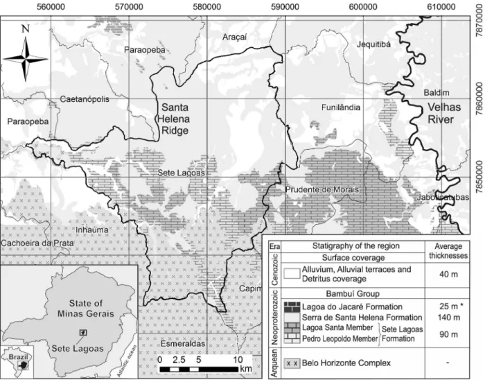
The study area is located in the state of Minas Gerais, Brazil, among the municipalities of Pedro Leopoldo,
Matozinhos, and Sete Lagoas, with Velhas River as the eastern boundary (Fig. 1). Geologically,
this area is located in the São Francisco Craton, where carbonated argillo-arenaceous sediments
are emplaced giving origin to the Bambuí Group,
who proposed the first stratigraphic column of the region, later modified by Oliveira (1967), Schöll and Fogaça (1979), Dardenne (1978) and,
fi nally, by Ribeiro et al. (2003). In addition, other important studies related to structural (Magalhães 1989), geochronological (Babinski and Kaufman 2003), hydrogeological (Pessoa 1996, 2005), and geological evolution (Nobre-Lopes 1995, Uhlein et al. 2004, Tuller et al. 2009) were carried out. Despite the geologic knowledge being well developed, the area needs work on integration and detailing of the geologic information. Thus, the primary goal of this paper was to contribute to the quality of the geologic cartography, as well as the spatial arrangement, and the structural framework of the lithologies found in this region. Aerial photography, geologic mapping, and the evaluation of 270 lithological well profi les located in Sete Lagoas and in the adjacent municipalities were integrated with the available data to provide a new geologic perspective of the region. As a result, the update to the geologic map of the municipality of Sete Lagoas, 14 geologic cross sections, and a geologic conceptual model were created.
GEOLOGICAL SETTING
The study area (Fig. 1) overlies the São Francisco Craton (Almeida 1977), which is represented by crystalline rocks from the Paleoproterozoic age formed by the agglutination of different craton blocks from the Archean age. Extension events occurred between 900 and 600 Ma. (Condie 2002) allowing Neoproterozoic silicate-carbonate sediments from the Bambuí Group to be deposited. Regionally, the Bambuí Group is about 300,000 km2 (Almeida 1977), including mainly the states
of Minas Gerais, Goiás, and Bahia. The basement being controlled by a faulting system causing the thickness of the sediments to be variable (Misi et al. 2007). According to seismic surveys conducted by Petrobras S.A., the central area of this group can have a thickness of 1,000 m, while in the
muni-cipality of Sete Lagoas it is estimated to 600 m thick on average (Pedrosa-Soares et al. 1994).
The sediments of the Bambuí Group were deposited in a low gradient stable epicontinental shelf in shallow water conditions, which explains a regional occurrence of the lithofacies. (Schobbenhaus 1984). Stratigraphically, there were three regressive sedimentary mega-cycles: 1) carbonated (Sete Lagoas Formation); 2) argillo-carbonated (Serra de Santa Helena and Lagoa do Jacaré formations); and 3) argillo-arenaceous (Serra da Saudade and Três Marias formations).
The Bambuí Group is represented by the following formations, from the base to the top: Carrancas (diamictites, sandstones, and rhythmites); Sete Lagoas (carbonate sequence); Serra de Santa Helena (siltstones, phyllites, slate, arkose, and marlstones), Lagoa do Jacaré (oolitic limestones); Serra da Saudade (siltstones, sands, and sandstones); and Três Marias (fl uvial platform sandstones) (Tuller et al. 2009).
The basement is represented by gneissic rocks associated with granitoids and migmatite zones from the Belo Horizonte Complex. Overlying the Bambuí Group, are the unconsolidated sediments from Cenozoic surface coverage (Tuller et al. 2009). The Bambuí Group is represented by the following formations, associated with mega-cycles 1 and 2 (Fig. 1):
2003): Pedro Leopoldo, at the base, composed of fi ne grained white limestones, dolomites, marlstones, and pelites; and Lagoa Santa, on the top, by medium grained black limestones; • Serra de Santa Helena Formation (Branco and
Costa 1961): having an area greater than 7,000 km² and represented by three stratigraphic members (Grossi-Sad et al. 1998): 1) lower, characterized by silt-clay rhythmites, generally carbonaceous, and dark shales (about 90 m thickness); 2) medium, composed of marble and shales (50 m thick); and 3) upper, consisting of shales, siltstones, slate cleavage, and cross bedding (around 140 m thick).
Regarding the structural geology, the main planar structures are faults, foliations and fractures, consisting of two types of faults (Danderfer Filho 1991, Tuller et al. 2009): normal and thrust, trending NNW-SSE. Kinematic indicators, such as stretching and mineral lineations, indicate tectonic transport from east to west, forming interstratal ramp thrust belts, accommodated in more argillous upper planes. The fi rst generation of the structures is composed of normal synsedimentary faults. Based on structural surveys, the Bambuí Group is divided into four structural domains, according to the magnitude of the deformation (Tuller et al. 2009): 1) high intensity of deformation domain, where
rocks from the Espinhaço Supergroup outcrop. The presence of mass transport commonly indicates movement from east to west; 2) intermediate domain, characterized by less intense deformation, more deformed to the east and less deformed to the west; 3) domain where the Bambuí Group rocks are presented less deformed to not deformed; and 4) domain less deformed at the far west portion of the area, affecting mainly the rocks from the Serra da Saudade Formation.
The study area is located only in the intermediate structural domain, extending from Velhas River to the far western border of the municipality of Sete Lagoas.
MATERIALS AND METHODS
Three sets of data were integrated to evaluate the geologic setting of the region. These included geologic mapping, aerial photography interpretation, and lithologic well log analysis. These methods will be presented sequentially followed by the approach to data integration.
Geologic mapping of the entire municipality of Sete Lagoas was carried out in a scale of 1:25,000. The classifi cation of the sedimentary rocks followed the defi nitions of Folk (1980) and the microscopic classifi cation of the carbonate rocks followed the definitions of Folk (1959) and Dunham (1962). For the metamorphic and igneous rocks, the classifi cation followed defi nitions of Winter (2001). All the data were recorded on paper topographic maps and converted to digital format. ArcGIS 10.1 was used throughout the project to construct the digital map. Later, integration of the fi eld data and the sheet geologic maps Baldim (SE.23-Z-C-III), Sete Lagoas C-II), Contagem (SE.23-Z-C-V), and Belo Horizonte (SE.23-Z-C-VI), scale 1:100,000, was performed. These maps were acquired from the CPRM database, available on: http://geobank.sa.cprm.gov.br/.
Aerial photography interpretation (scale 1:40,000, dated 1977) and the SRTM image
(Shuttle Radar Topography Mission), Sheet SE-23-Z-C, acquired from the EMBRAPA’s website were evaluated to defi ne the lithologic contacts (http:// www.relevobr.cnpm.embrapa.br).
Information about lithologic well logs was taken from the SIAGAS database (http://siagasweb. cprm.gov.br). A series of 218 lithologic well profi les were acquired, located in the municipalities of Baldim, Caetanópolis, Capim Branco, Cordisburgo, Esmeralda, Fortuna de Minas, Funilândia, Inhaúma, Inimutaba, Lagoa Santa, Maravilhas, Matozinhos, Papagaio, Paraobepa, Pedro Leopoldo, Prudente de Morais, São José da Lapa, and Sete Lagoas. In addition, 52 public well logs located in Sete Lagoas were analyzed, kindly provided by Water Supply and Sewage Service database (SAAE) [SAAE -Serviço de Abastecimento de Água e Esgoto]. Out of the 270 lithologic well profi les that were analyzed, the best and the most reliable were chosen.
In order to help understand the areas where data were sparse, and thus estimate the geologic contact depth, kriging interpolations of the data were carried out in Surfer 8 software.
The complete data sets were entered in a GIS database and georeferenced in ArcGIS 10.1 software. The coordinate system was Universal Transverse Mercator (UTM) projection, Zone 23, datum SAD 69, with units in meters.
Finally, 14 geologic cross sections were made (NW-SE and NE-SW), at a scale of 1:25,000, within the municipality of Sete Lagoas, and a scale of 1:100,000 in the surrounding areas. The topographic elevations were extracted from the SRTM image, using the Global Mapper 11 software.
RESULTS AND DISCUSSION
GEOLOGIC MAPPING
grained clastic rocks from the Serra de Santa Helena Formation, and the unconsolidated sediments from the Cenozoic surface coverage. Rocks from the Carrancas Formation (diamictites, sandstones, and rhythmites), stratigraphically below the Sete Lagoas Formation, were not identifi ed and mapped within the study area, but were mapped over the southeast and northwest of the area by Ribeiro et al. (2003) and Tuller et al. (2009). In the case of the Lagoa do Jacaré Formation, these oolitic limestone rocks, with a mean thickness of 25 m, can be found in the far northwest portion of the area and it are more detailed by Tuller et al. (2009).
Belo Horizonte complex
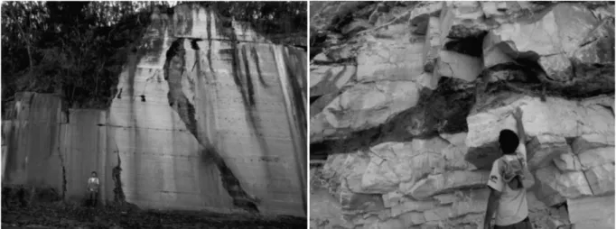
This igneous/metamorphic basement complex occurs in the SW and SE regions of the area (Fig. 6). It is characterized by a set of gneissic rocks and migmatite zones, with polymetamorphic features, corresponding to the São Francisco Craton (Ribeiro et al. 2003). The contacts between the different lithotypes are transitional, between gneiss, migmatites and/or granitoids. Stretched minerals are common, with presence of concordant shearing zones, layers and/or lengthened veins, many times boudinaged. The granitoids are light
gray to whitish, with medium to coarse grained, sometimes with sparse porphyroblasts of tabular feldspars, xenoliths, or restites from partial fusion. Petrographically, they vary in composition with hornblende gneisses, biotite gneisses, or amphibole gneisses, whose protolytes would be granites and tonalites, subjected to a metamorphism of the amphibole facies, with hydrothermal alteration (Tuller et al. 2009). This complex was intensely affected by basic injections, resulting in a group of basic rock dikes (Ribeiro et al. 2003). In the south portion of Sete Lagoas, epigenic and igneous metamorphic/migmatite rocks with plutonic feature are common (Fig. 2), as well as intrusions of mafi c rocks, fi lling the fracture planes. Schistosity and transposition foliation are also observed.
Sete Lagoas formation
This limestone occurs mainly in the SE region of the area. In the municipality of Sete Lagoas, it occurs in the central and western portions, and in the Santa Helena Ridge foothills (Fig. 6). The lower contact with the basement is abrupt, discordant, and tectonic, with faults. The upper contact with the Serra de Santa Helena Formation is also abrupt (Figs. 9 and 10).
The Sete Lagoas Formation is divided by two members: Pedro Leopoldo, at the base, composed of fine grained white limestones, dolomites, marlstones and pelites; and Lagoa Santa, on the top, composed of medium grained black limestones.
According to Vieira et al. (2007), there are six lithological facies, four in the Pedro Leopoldo Member and two in the Lagoa Santa Member: Facies 1, characterized by light gray to beige calcilutite, with intercalations of yellowish pelite and truncated wave-ripple stratifi cation, and tidal plain sedimentation environment, with possible storm infl uence; Facies 2, with aragonite crystals, constituting tabular beds and/or layers of sea sedimentation in deep waters; Facies 3, constituted by dolomite rocks, which are disposed in overlaid benches with metric to sub-metric thickness; Facies 4, beige to light gray calcilutites, plane-parallel stratification, with rithmite terrigenous and carbonate sedimentation, suggesting calm to slightly agitated waters sedimentation; Facies 5, characterized by black calcarenites and calcisiltites, plane-parallel lamination, wave truncation, medium sized crossed stratifi cations; and Facies 6, represented by well preserved stromatolites, from a tidal fl at environment.
In relation to the lithological facies mentioned above, 3 of the 4 facies in the Pedro Leopoldo Member were confi rmed:
• Facies 1: located in the Canaã quarry (near the Federal Road Police post, BR-040). It has a decametric thickness of approximately 40 meters, represented by micritic limestone with medium to dark gray recrystallized sparite grains. The occurrence of meter-scale recumbent bends is common, with recrystallization and intergrowth of calcite minerals parallel to the bedding, especially in joints;
• Facies 2: located in the Ilcon quarry (South-East of the municipality of Sete Lagoas). It is characterized by regular and homogeneous
intercalation of micritic stratums, with thicknesses of 15 - 20 cm, and an intercalation of marlstone levels with brown-pink color, with terrigenous grain sizes. Occurrence of euhedral millimetric pyrite grains is also observed, with well developed cubic form; • Facies 3: located in the Sambra, Paraíso,
Capão do Meio quarries, and in the Capão do Inferno farm. Described as micritic rock, with occurrence of chlorite placoid minerals, and well-developed bedding planes. The presence of pseudomorph aragonite arborescentes, with reddish color, recovered with cream colored micrite are observed.
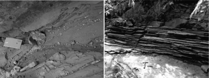
This Member presents important dissolution developed either in bedding planes (most frequent) and in sub-vertical fractures (less common), which are fi lled with terrigenous material (Fig. 3).
In relation to the lithological facies seen in the Lagoa Santa Member:
• Facies 5: rock with variable character, between gray micro-sparites and calcarenites, plane-parallel laminate;
• Facies 6: occurrence of stromatolite layers, type gyminosolens (Marchese 1974) (Fig. 4). This Member presents important dissolution resulting in caves and grottoes (Fig. 4).
Microscopically, the limestones from Pedro Leopoldo Member are composed of 85% micrite, 8% sparite, and 7% quartz, classifi ed as micrite (Folk 1959) or mudstone (Dunham 1962). The limestones from Lagoa Santa Member are 55% sparite, 30% ooids, and 15% micrite, classifi ed as an oobiosparite (Folk 1959) or grainstone(Dunham 1962).
Serra de Santa Helena formation
on the basin’s border. The overlaying Lagoa do Jacaré and Serra da Saudade formations are characterized by transitional contacts and can be locally abrupt (Tuller et al. 2009) (Figs. 9 and 10). This formation presents schistosity type foliation, discordant and/or concordant with the bedding. This whole sequence is cut by abundant bended quartz-feldspar veins, usually fi lling fractures or relief zones, generated during extensional events (Tuller et al. 2009).
In Sete Lagoas, it was possible to see intercalated levels of slate rocks with well-developed cleavage planes in thin layers, presenting gray-greenish sericite. Locally, less developed
cubic grains of pyrite may occur. At the base, slate, siltstone, and argillite are found, very friable. Vertical fractures fi lled with quartz veins with well-developed hexagonal forms (Fig. 5) and, locally, pegmatite veins, rich in feldspar and calcitite grains were also observed.
Cenozoic surface coverage
This unit (Fig. 6) is divided into 1) detritus coverage, 2) alluvial terraces, and 3) alluviums.
The detritus coverage is composed by unconsolidated sediments with predominant red color, arenaceous-argillous with levels of gravel,
Figure 3 - Sub-vertical fractures (left, UTM: 565445/7851910) and bedding plane dissolution, most frequently observed, fi lled with terrigenous sediments (right, UTM: 563101/7853620).
Figure 5 - Quartz veins in sub-vertical fracture systems in phyllites layers (top of the Santa Helena ridge - left, UTM: 577708/7852972) and slate with a well-developed rock cleavage coincident to the bedding planes (right, UTM: 576695/7852000).
!"
#$&'
(&'
&')'
&')*'
+(! ',
.
.
( /
0
.'
which occur indistinctly on all units, but mainly on the rocks from the Serra de Santa Helena Formation. The alluvial terraces occur along the larger streams and rivers in the area, such as the Velhas River and its effl uents. They are up to 5 m thickness and mainly consist of argillo-arenaceous semi-consolidated sediments, with whitish to yellowish and reddish color. Finally, the alluviums occur along the meanders of the big watercourses. They are composed of fine to coarse grained sediments, with discontinuous levels of quartz pebbles, in general rounded and not well sorted, and siltstone and sandstone placoids.
In Sete Lagoas, the pedogenic features obser-ved were: 1) nitosoil: argillo-arenaceous grains, brown-reddish color and “block” form. Its breaking plane presents a feature known as “cerosity”, a result from the concentration of argillous grains; 2) detritus-laterite: rich in mature quartz fragments and pebbles, cemented by a white-yellowish siltic-argillous matrix; 3) agrisol: well developed horizons, with well selected clay grains (at the base), grading for arenaceous grains, also with well selected grains on the top; 4) latosoil: fi ne to coarse grains, with well cemented grains by the occurrence of aggregated oxides and clay, in addition to having red-yellowish color; 5) neosoil: low diagenetic degree, argillous matrix supporting the grains varying among sand, pebble and boulder; and 6) alluvial soil: constituted of alluvial argillo-arenaceous grains, carried by a fl uvial body, and it may vary to argillo-silty.
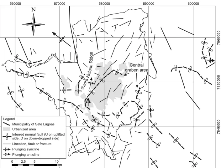
STRUCTURAL GEOLOGY
Included in the intermediate structural domain with low intensity of deformation (Tuller et al. 2009), within the municipality of Sete Lagoas, no lithostructural contacts with thrust features were seen, and only abrupt deposition contacts were noted. However, from the lithologic well profi les, abrupt changes of depth to the basement were observed. In addition, similar basement level
changes were observed between its outcrops and the adjacent lithologic well profi les. From these data, it is suggested that faults displaced the lower stratigraphic sequences, placing them in contact with upper blocks, which was observed in previous studies, in the eastern most portion of the area, out of the municipality Sete Lagoas.
The upper contact between Sete Lagoas and Serra de Santa Helena formations and Belo Horizonte Complex is abrupt, with a low angle. It is preferably developed in bedding rocks, associated with slate and phyllite from the Serra de Santa Helena Formation, and to the ductile-ruptile behavior phases of the limestone from Sete Lagoas Formation, locally represented by kink bands.
In the case of Sete Lagoas Formation, the contact between Pedro Leopoldo (basal) and Lagoa Santa (upper) members is also abrupt, horizontal and well defi ned, which was confi rmed in all quarry outcrops. Sigmoidal deformations were observed specifi cally in the Lagoa Santa Member, suggesting a stage where the formation was deformed in a ductile regimen (Fig. 7).
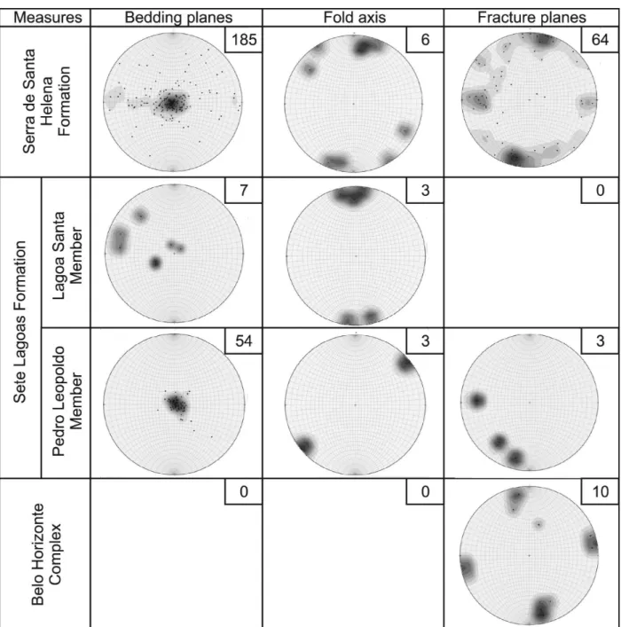
The main structures observed in the municipality of Sete Lagoas were fractures, folds, bedding planes, and foliations (Fig. 8). The only observed evidence of microfaulting was seen in the Serra de Santa Helena Formation, with displacement of a few millimeters, located on the top of the Santa Helena Ridge. For the Belo Horizonte Complex, sub-vertical fracture planes are common, with NNW/SSE direction, and main attitude N347/83.
N092/67. In the Lagoa Santa Member, the bedding planes are well defined, and the most observed attitude was N060/24. Concerning the fold axes, the most frequent was N360/13. The structural evidences explain the presence of outcrops in the Lagoa Santa Member in lower topography and its occurrence in the center-west of Sete Lagoas.
Finally, the Serra de Santa Helena Formation presents structural features with ductile-ruptile behavior, a consequence of the regional tectonic evolution, subdivided in: 1) bedding planes with attitude of N060/03 (15% of the 185 measured), in addition to the 6 measured related to the fold axis with main attitudes of N009/13; and 2) fracturing planes with subvertical character and fi lled in with quartz or pegmatite veins. The main attitude was N013/77 (13% of the 64 measured), following ESE-WSW orientation (Fig. 8).
SPATIAL DISTRIBUTIONOFTHE GEOLOGIC FORMATIONS
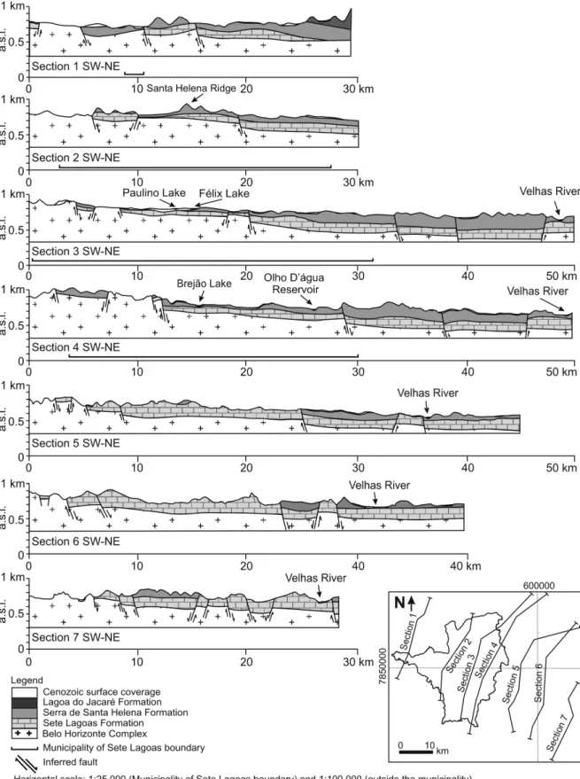
The basement outcrops in the SW portion of the study area with elevations between 750 and 950 m.a.s.l. and dips in the NE direction (Figs. 9, 10 and 11). The minimum surface contact is approximately 400 m.a.s.l., located in the north near the Velhas River. The overlying sediments from the Sete Lagoas and Serra de Santa Helena formations follow the dip of the basement.
According to the geologic cross sections, it was possible to propose, indirectly, a horst and graben system controlled by faulting, which indicated different basement depths over small lateral distances (e.g. 120 m offset in 1.4 km; 140 m in 2.5 km; or 200 m in 5 km). As an example, a lithologic well profile, located approximately 800 m from where the basement outcrops, shows a depth to basement of 80 m.
The Sete Lagoas and Serra de Santa Helena formations follow this horst and graben system, presenting thinner layers on the basin border in the SW region, and higher thickness in the NE (cross sections 1 to 14). In the case of the Sete Lagoas Formation, the limestones dip and become thicker to the northeast, being covered almost totally by the Serra de Santa Helena Formation, where these limestones arise mainly in the Santa Helena Ridge foothills and in the municipalities located to the southeast, near the Velhas River.
The Serra de Santa Helena Formation is situated immediately over the Sete Lagoas Formation, normally with abrupt contact. The contacts with basement are also abrupt, indicating that their sediments were deposited in area with little relief. This formation becomes thicker to the NE and contains bedding planes, which dip to the NE, and
thinner on the basin borders and near the Velhas River. These formations can reach 160 m thickness, seen in the north of Sete Lagoas (cross section 3) and in the Santa Helena Ridge (estimated values).
The thickness of the Cenozoic surface coverage is low in comparison to the other geologic formations. The best representation was seen in the central part of Sete Lagoas (urbanized area) and in the western part of this municipality, with
approximate values of 40 m in thickness (cross sections 3, 9 and 10).
In the urbanized area of Sete Lagoas, for the homonym formation, an antiform was interpreted (Fig. 11), with bedding planes oriented to the North (cross section 2) and surface contact around 500 m.a.s.l. (estimated, seen in section 4) and 580 m.a.s.l. (data from a stratigraphic drill hole made by SAAE, located on North of Sete Lagoas – seen in
section 3 - near 40 km in the x-axis). The majority of the urbanized area is included in a graben area,
fi lled with limestones and unconsolidated sediments (cross sections 3, 10 and 11; also see Fig. 11).
In the case of the Santa Helena Ridge, located near to the central part of Sete Lagoas, it was possible to deduce an upward displacement of the basement, indicated by a horst (cross sections 3, 10 and 11). This horst might have elevated the stratigraphic sequence, where the Sete Lagoas and Serra de Santa Helena formations have more elevated altitudes than other regions. The fact that this stratigraphic sequence is cut by fractures fi lled quartz veins, the ridge is more resistant to erosion.
GEOLOGIC CONCEPTUAL MODEL
A geologic conceptual model of the municipality of Sete Lagoas and the surroundings (Fig. 12) and a schematic synthesis model about the geological
evolution were proposed (Fig. 13).
From the extensional events between 900 and 600 Ma. (Condie 2002) in the São Francisco Craton, the São Francisco Basin was originated, depositing silicate-carbonate sediments of the Bambuí Group from the Neoproterozoic age, where the study area is included, directly on the border of this basin. These Neoproterozoic sediments were deposited
on a stable epicontinental shelf with a low gradient,
0 2.5 5 10
km D U D U D U D U D U D U D U D U D U D U D U D U D U D U D U D U D U D U D U D U D U D U D U D U D U D U D U D U D U D U D U D U D U D U D U D U D U D U D U D U D U D U
which had three regressive sedimentary mega-cycles (with argillo-carbonate origin), giving origin to the Sete Lagoas and Serra de Santa Helena formations, respectively.
Around 740±22 Ma. (Babinski et al. 2007), 630 Ma. (Caxito et al. 2012), or 540 Ma. (Warren et al. 2014), the Sete Lagoas Formation, by carbonate depositional systems with intermediary internal and external ramps (Lima 1997), gave origin to the limestones of the Pedro Leopoldo Member, at the base, characterized by fine grained white
limestones (in some cases, with dolomite and/ or pelite level), and the Lagoa Santa Member, on the top, represented by medium grained black limestones.
Later, over the rocks from the Sete Lagoas Formation, a transgressive cycle (Ribeiro et al. 2003) characterized by sub-coastal sea and relatively deep and weak fl ow enabled the deposition of pelite materials with plane-parallel stratums, crossed stratifi cations, and wave marks giving origin to the Serra de Santa Helena Formation. This formation
might have achieved minimum thickness values as low as 160 m (confirmed in lithologic well profi les). At the end of this cycle, the deposition of silicate-carbonate sediments started giving origin to the Lagoa do Jacaré Formation, found in the far NNW part of the study area.
Due to the deformation of the Espinhaço Supergroup in the Brazilian age (~600 Ma.) (Trompette et al. 1993) and the proximity of this region (structural domain 1 - higher intensity of deformation) to the study area (structural domain 2 – intermediate deformation magnitude), the rocks from the Bambuí Group were intensely faulted and bended to the East, close to the stress coming from this deformation (Alkmim and Martins-Neto 2001). In the west of the area, the structural features were less expressive and the sedimentary features were more preserved. These factors resulted in a
horst and graben system, controlled by faulting, displacing the stratigraphic sequences, which enabled lithologic sequences of different ages side by side. Thus, the lower limestones of the Sete Lagoas Formation reached the surface in some areas.
Within the municipality of Sete Lagoas, it was observed that the limestones from the Sete Lagoas Formation, especially the Pedro Leopoldo Member, demonstrate important dissolution macro-features developed either in bedding planes (most frequent) and in subvertical fractures (less common). Some of these dissolution zones were fi lled with terrigenous material, suggesting a past meteoric water fl ow. In the case of the Lagoa Santa Member, the main dissolution features found were dry caves and grottoes, suggesting groundwater paleoconduits (e.g. Rei do Mato Cave). These evidences could
suggest recent geomorphologic processes, such as a past meteoric water fl ow, or could have started at the time when groundwater fl ow paths started to develop, even if these limestones had not yet been exposed. As the timing of these processes is not precisely known, it is suggested a specifi c study to be conducted to better understand more about the origin of these processes.
Finally, the Cenozoic unconsolidated sediments deposited in the central portion of Sete Lagoas were a result of weathering and erosion of Santa Helena Ridge. These unconsolidated sediments also were deposited along the beds of the Velhas River and in areas of low relief.
CONCLUSIONS
The uses of data from geologic mapping combined with a good database of lithologic well profi les become an efficient set of tool to facilitate the spatial visualization and determine the geometry of the geologic formations in the subsurface and its side continuities. This fact also helped to identify possible blocks displaced indirectly by faults.
The study area is along basement border, a result of extensional events in the São Francisco Craton, where silicate-carbonate sediments from the Neoproterozoic age were emplaced giving origin to the Bambuí Group.
Due to the relative proximity of this area with the Serra do Espinhaço (situated to the east and which undergone intense deformation), the Bambuí Group presents a horst and graben system, controlled by faulting, displacing the stratigraphic sequences, which enables formations with different ages side by side.
In relation to the thickness of sedimentary layers, the NE portion of the area is estimated to approximately 400 m, near the Velhas River.
According to lithological well profiles, the limestones from the Sete Lagoas Formation present horizontal continuity, from the basement border to the Velhas River.
The Santa Helena Ridge was interpreted as a horst, which elevated the stratigraphic sequence, causing the Sete Lagoas and Serra de Santa Helena formations to have higher altitudes than in other regions. Considering that fracture filled quartz veins cut this stratigraphic sequence, the ridge became more resistant to erosion.
The urbanized area located in the municipality of Sete Lagoas is in a graben, where limestones from Sete Lagoas Formation and unconsoli dated sediments from Cenozoic surface coverage having on average 90 m and 40 m in thickness, respectively.
ACKNOWLEDGMENTS
To the companies
Servmar Ambiental e
Engen-haria
and Serviço de Abastecimento de Águae Esgoto (SAAE), and to Fundação de Amparo à Pesquisa do Estado de São Paulo (FAPESP) (process 2012/12846-9), for the fi nancial support and the information release. A special thanks to Dr. Geane Carolina Cavalcante, for the contributions in the chapter about the structural geology, to Dr. Bernardo Tavares Freitas, for the contributions in the fi eldwork, and to geologist Kyle Spears for the grammar revision and geologic advice.
RESUMO
geológica da região, com obtenção do mapa geológico detalhado de Sete Lagoas, 14 seções geológicas cruzadas e um modelo geológico conceitual. O estudo mostrou que a área se encontra em um contexto geológico de borda de bacia, apresentando uma geometria condicionada por sistema de horsts e grábens. Essa característica estrutural deslocou sequências estratigráfi cas posicionando-as lado a lado, com sequências litológicas de idades distintas.
Palavras-chave: modelo conceitual, geometria das formações, geologia, estratigrafi a.
REFERENCES
ALKMIM FF AND MARTINS-NETO MA. 2001. A bacia
intracratônica do São Francisco: arcabouço estrutural e cenários evolutivos. In: Pinto CP and Martins-Neto MA (Eds), Bacia do São Francisco: geologia e recursos minerais. Belo Horizonte: Sociedade Brasileira de Geologia-MG, CBMM, COMIG, GEOSOL, p. 9-30.
ALMEIDA FFM. 1977. O Cráton do São Francisco. Rev Bras
Geoc 7: 349-364.
BABINSKI M AND KAUFMAN AJ. 2003. First direct dating
of a Neoproterozoic post-glacial cap carbonate. In: South American Symposium on isotope Geology, 4, 2003, Salvador. Short Papers, p. 321-323.
BABINSKI M, VIEIRA CV AND TRINDADE RIF. 2007. Direct
dating of the Sete Lagoas cap carbonate (Bambuí Group, Brazil) and implications for the Neoproterozoic glacial events. Terra Nova 19(6): 401-406.
BRANCO JJR AND COSTA MT. 1961. Roteiro da excursão
Belo Horizonte – Brasília. In: Congresso Brasileiro de Geologia, 14, Brasília. Instituto de Pesquisas Radioativas, UFMG, Publicação 15, Belo Horizonte, 25 p.
CAXITO FA, HALVERSON GP, UHLEIN A, STEVENSON R,
DIAS TG AND UHLEIN GJ. 2012. Marinoan glaciation in
east central Brazil. Precambrian Res 200-203: 38-58.
CONDIE KC. 2002. The supercontinent cycle: are there two
patterns of ciclicity? J Afr Earth Sci 35: 179-183.
DARDENNE MA. 1978. Síntese sobre a estratigrafia do Grupo
Bambuí no Brasil Central. In: Congresso Brasileiro de Geologia, 30. Recife. Anais Recife: Sociedade Brasileira de Geologia 2: 597-610.
DANDERFER FILHO A. 1991. Cartografia geológica dos
municípios Sete Lagoas, Funilândia, Lagoa Santa, Pedro Leopoldo, Vespasiano, Capim Branco, Matozinhos e Prudente de Morais – Capítulo 6 - Geologia Estrutural. Projeto Vida. MMe – CPRM.
DUNHAM RJ. 1962. Classification of carbonate rocks according
to depositional texture. In: Ham WE (Ed), Classification of carbonate rocks. Am Assoc Petrol Geol Mem 1, Tulsa, Oklahoma, p. 108-121.
FOLK RL. 1959. Practical petrographic classification of limestones. Bull Am Assoc Petrol Geologists 43: 1-38.
FOLK RL. 1980. Petrology of Sedimentary Rocks. Hemphill Publishing, Austin, TX, 184 p.
GROSSI-SAD JH, CHIODI-FILHO C AND CHIODI DK. 1998.
Panorama do setor de ardósias Estado de Minas Gerais, Brasil. Belo Horizonte: COMIG. CD- ROM.
MAGALHÃES PM. 1989. Análise estrutural qualitativa das
rochas do Grupo Bambuí, na porção sudoeste da Bacia do São Francisco. Dissertação (Mestrado) – escola de Minas. Universidade Federal de Ouro Preto, Ouro Preto, 100 p. (Unpublished).
MARCHESE AG. 1974. Litoestratigráfia Y Petrología del
Grupo Bambuí en los estados de Minas Gerais y Goiás, Brasil. Rev Bras Geoc 3: 172-190.
MISI A, KAUFMAN AJ, VEIZER J, POWIS K, AZMY K,
BOGGIANNI PC, GAUCHER C, TEIXEIRA JBG, SANCHES
AL AND IYER SSS. 2007. Chemostratigraphic Correlation of Neoproterozoic Successions in South America. Chem Geol 237: 161-185.
NOBRE-LOPES J. 1995. Faciologia e gênese dos carbonatos do Grupo Bambuí na região de Arcos, Estado de Minas Gerais. Dissertação (Mestrado em Geologia Sedimentar) - Instituto de Geociências. Universidade de São Paulo, SP, 166 p. (Unpublished)
OLIVEIRA MAM. 1967. Contribuição à geologia da parte Sul
da Bacia do São Francisco e áreas adjacentes. In: Coletânea de Relatórios de Exploração, 1. RJ: Petrobras 3: 71-105.
PEDROSA-SOARES AC, DARDENNE MA, HASUI Y, CASTRO
FDC, CARVALHO MVA AND REIS AC. 1994. Mapa Geológico do estado de Minas Gerais e Nota Explicativa, Secretaria de Recursos Minerais, Hídricos e Energéticos, Companhia Mineradora de Minas Gerais (COMIG), mapas e texto, 97 p.
PESSOA P. 1996. Caracterização Hidrogeológica da Região de
Sete Lagoas - MG: Potencialidades e Riscos. Dissertação de Mestrado. Departamento de Geociências, Universidade de São Paulo. São Paulo. (Unpublished).
PESSOA P. 2005. Hidrogeologia dos aquíferos cársticos
cobertos de Lagoa Santa, MG. Tese de Doutorado. Progra-ma de pós-graduação em Saneamento, Meio Ambiente e Recursos Hídricos. Universidade Federal de Minas Gerais - UFMG. MG.
RIBEIRO JH, TULLER MP AND DANDERFER FILHO A. 2003.
Mapeamento geológico da região de Sete lagoas, Pedro Leopoldo, Matozinhos, Lagoa Santa, Vespasiano, Capim Branco, Prudente de Morais, Confins e Funilândia, Minas Gerais (1:50.000) – In: Projeto Vida. Belo Horizonte: CPRM. (CD-ROM).
SCHOBBENHAUS C. 1984. Geologia do Brasil. Departamento
Nacional de Produção Mineral, p. 275-277.
SCHÖLL WU AND FOGAÇA ACC. 1979. Estratigrafia da Serra
TROMPETTE RR, UHLEIN A, SELVA ME AND KARMANN I. 1993. O Cráton brasiliano do São Francisco - Uma revisão. Rev Bras Geoc 22(4): 481-486.
TULLER MP, RIBEIRO JH, SIGNORELLI N, FÉBOLI WL
AND PINHO JMM. 2009. Projeto Sete Lagoas - Abaeté, Estado de Minas Gerais (CPRM) Orgs.- Belo Horizonte: CPRM-BH. 06 mapas geológicos, escala 1:100.000 (Série Programa Geologia do Brasil) versão impressa e em meio digital, textos e mapas, 160 p.
UHLEIN A, LIMA ONB, FANTINEL LM AND BAPTISTA MC.
2004. Excursão 2. Estratigrafia e evolução geológica do Grupo Bambuí, Minas Gerais. In: Congresso Brasileiro de Geologia, 42, Araxá - MG.
VIEIRA LC, TRINDADE RIF, NOGUEIRA ACR AND ADER
M. 2007. Identification of a Sturtian cap carbonate in the neoproterozoic Sete Lagoas carbonate platform, Bambuí Group, Brazil. Comptes Rendus, Géosciences 339: 240-258.
WARREN LV, QUAGLIO F, RICCOMINI C, SIMÕES MG, POIRÉ
DG, STRIKIS NM, ANELLI LE AND STRIKIS PC. 2014. The puzzle assembled: Ediacaran guide fossil Cloudina reveals an old proto-Gondwana seaway. Geology 42: 391-394.
WINTER JD. 2001. An Introduction to Igneous and