“main” — 2013/11/13 — 23:29 — page 43 — #1
Revista Brasileira de Geof´ısica (2013) 31(1): 43-57 © 2013 Sociedade Brasileira de Geof´ısica ISSN 0102-261X
www.scielo.br/rbg
THE POTENTIAL OF THE BARREIRAS AQUIFER IN THE LOWER COURSE OF THE
DOCE RIVER, RIO GRANDE DO NORTE STATE, NORTHEAST BRAZIL – INTEGRATION
OF HYDROGEOLOGICAL AND GEOPHYSICAL DATA
Leandson Roberto Fernandes de Lucena
1, Josibel Gomes de Oliveira Jr.
1,
Walter Eugˆenio de Medeiros
1and Marcelo Augusto de Queiroz
2ABSTRACT.The present article is a synthesis of studies developed by the Fundac¸˜ao Norte-Rio-Grandense de Pesquisa e Cultura-FUNPEC and Universidade Federal do Rio Grande do Norte-UFRN for the Companhia de ´Aguas e Esgotos do Rio Grande do Norte-CAERN, in the lower course of Doce River, RN. This paper also presents alternatives to increase the water supply from wells in the Barreiras Aquifer located to the north of Natal district, RN, considering the degraded water quality due to nitrate contamination from the right margin of Doce River. The methodology was based on the combined use of hydrogeological and geophysical techniques (gravity and electrical resistivity). The regional structure was previously characterized by morphotectonic analysis and gravimetric and geoelectric data interpretation. According to these data, two preferential fault directions (NW and NE) directly influence local geometry of the aquifer causing abrupt variations of the saturated thickness. The potential of the Barreiras Aquifer increases gradually on the left bank of Doce River from east to west, due to larger spacing between hydrogeological equipotential surface and larger saturated thickness. These observations provided the basis to locate a new water collection area, where new wells are going to be drilled with 300 m3/h estimated total discharge.
Keywords: Barreiras Aquifer, Doce River-RN, geophysical analysis, hydrogeological potential.
RESUMO.O presente artigo representa uma s´ıntese de estudos desenvolvidos pela Fundac¸˜ao Norte-Rio-Grandense de Pesquisa e Cultura-FUNPEC e Universidade Federal do Rio Grande do Norte-UFRN para a Companhia de ´Aguas e Esgotos do Rio Grande do Norte-CAERN, na ´area do baixo curso do Rio Doce-RN. O mesmo objetivou apontar alternativas para o incremento do abastecimento d’´agua proveniente de poc¸os no Aqu´ıfero Barreiras na zona norte do munic´ıpio de Natal-RN, tendo em vista o agravamento da contaminac¸˜ao de captac¸˜oes da margem direita do Rio Doce por nitrato. A metodologia adotada foi fundamentada no emprego conjunto de t´ecnicas de hidrogeologia e geof´ısica (gravimetria e eletrorresistividade). A estruturac¸˜ao regional, caracterizada previamente a partir de an´alise morfotectˆonica e interpretac¸˜ao de dados gravim´etricos e geoel´etricos, foi evidenciada nas direc¸˜oes preferenciais NW e NE, influenciando diretamente na geometria local do aqu´ıfero na forma de variac¸˜oes bruscas de sua espessura saturada decorrente dos falhamentos. A potencialidade do Aqu´ıfero Barreiras apresenta um acr´escimo gradativo na margem esquerda do Rio Doce de leste para oeste, decorrente de maiores espac¸amentos entre equipotenciais hidrogeol´ogicas e espessuras saturadas maiores. Estas observac¸˜oes fundamentaram a locac¸˜ao de uma sub´area a leste da captac¸˜ao Rio Doce da CAERN como bastante promissora para a execuc¸˜ao de uma segunda bateria de poc¸os, com descarga total estimada da ordem de 300 m3/h.
Palavras-chave: Aqu´ıfero Barreiras, Rio Doce-RN, Geof´ısica, potencialidade hidrogeol´ogica.
1Universidade Federal do Rio Grande do Norte, Departamento de Geof´ısica, P´os-Graduac¸˜ao em Geodinˆamica e Geof´ısica, Campus Universit´ario, Lagoa Nova, 59078-700 Natal, RN, Brazil. Phone: +55(84) 3342-2237; Fax: +55(84) 3342-2503 – E-mails: [email protected]; [email protected];
2Companhia de ´Aguas e Esgotos do Rio Grande do Norte, Gerˆencia de Hidrogeologia e Perfurac¸˜ao de Poc¸os, Av. Senador Salgado Filho, 1555, Tirol, 59015-000 Natal, RN, Brazil. Phone: +55(84) 3232-4100 – E-mail: [email protected]
“main” — 2013/11/13 — 23:29 — page 44 — #2
44
THE POTENTIAL OF THE BARREIRAS AQUIFER IN THE LOWER COURSE OF THE DOCE RIVER, RN, BRAZILINTRODUCTION
The Water and Sewage Company of Rio Grande do Norte State (Companhia de ´Aguas e Esgotos do Rio Grande do Norte – CAERN) has been facing lately increasing contamination of the water uptake wells by nitrate in the northern area of Natal, the state capital. Therefore, alternatives are being sought to meet the water demand while a definitive solution to this contamination is found (completion of a sanitation program, for example). Thus, the lower course of the Doce River (Fig. 1), especially the left bank, is quite promising due to its proximity to the northern Natal area and the apparent adequate levels of nitrate, when considering the low population density and low occurrence of potentially contam-inating sources.
Studies developed in northeastern Brazil show signs that the regional geological structures have a strong influence on the hy-drogeological and petrophysical context, particularly along the Cenozoic sedimentary terrains (Lucena & Queiroz, 1996; Lu-cena et al., 1999, 2006; Balsamo et al., 2010; Rodrigues et al., 2011). These studies show, among other aspects, the delimita-tion of areas with high transmissivity, resulting from increased saturated thickness caused by local structural compartmentaliza-tion of the Barreiras Aquifer (Tertiary-Quaternary age). This was suggested by the substantial increase of flows in wells within lo-cal structural grabens (Lucena & Queiroz, 1996; Lucena et al., 1999). These studies further suggest conditioning of the ground-water flow through semi-impermeable side barriers (Cretaceous aquitard), also caused by faults. Another aspect characterized was the prominent reduction of porosity in sandstones aquifers of the Barreiras Formation along fault zones (Balsamo et al., 2010).
Therefore, this work reports the exploratory hydrogeological study performed in the lower Doce River area (Extremoz-RN), in order to increase the volume and improve the quality of the water supply to Natal, RN. This mainly involved the identification of the most promising sub-areas for water collection, highlighting lo-cal positive anomalies of saturated thickness. This research was coordinated by the Rio Grande do Norte (RN) State Research and Culture Foundation-FUNPEC and Rio Grande do Norte Federal University-UFRN. The general methodology employed was based on a set of hydrogeological, structural and geophysical techniques (gravity and electrical resistivity), which enabled the creation of geological and hydrogeological sections, the potentiometry of the Barreiras aquifer and a geometry model of the local saturated zone. The gravimetric and electric geophysical models used were in-strumental in obtaining the results. Previous surveys of adjacent areas evidenced a strong correlation between deep and shallow fragile structures from the interpretation of residual gravimetric fields (Lucena, 2005; Lucena et al., 2006) while electrical
resis-tivity is the most widely used geophysical methodology to study shallow aquifers, either in sedimentary or crystalline soils/terrains (Rubin & Hubbard, 2005; Kirsch, 2006; Feitosa et al., 2008).
METHODOLOGY
The methodology used was a combination of geophysical, struc-tural and hydrogeological techniques (gravity and electrical resis-tivity). The geological characterization consisted on the revision and updating the bibliographical and cartographical material, as well as available remote sensing products, particularly including field surveys to detail the local geology of Natal area and its sur-roundings, based on the geological map of Rio Grande do Norte State published by the Brazilian Geological Survey (CPRM, 2006). Additionally, the interpretation of residual gravity field and vertical electrical sounding was used to define the fault distribution and orientation.
The potentiometric map of the lower Doce river area was prepared according to the classical procedures used in this type of survey (Castany, 1975). Initially, the wells in the area were reg-istered and later identified in the field, and it was checked, among other features, whether they were drilled in the Barreiras aquifer. The selected water wells were topographically leveled for further measurements of their static levels. This had the objective of indi-vidualizing the recharge and discharge areas of local groundwater, locating the major surface water bodies in the regional hydrogeo-logical context and defining the main flow fronts.
The analysis of the gravimetric geophysical data shows possible relationships between the deep structure (crystalline basement and Mesozoic basin) and the overlapping sequences, with ultimate implications in the geometry of the Barreiras aquifer and the tectono-structural control of river valleys. Consistent re-sults have already been reported in previous studies of the east-ern region of Rio Grande do Norte, by Lucena & Queiroz (1996) and Lucena et al. (2006). The gravimetric data used are part of the database of the Geophysics group of the Rio Grande do Norte Federal University-UFRN. The surveys were conducted using LaCoste & Romberg gravity meter and geodetic global position-ing system. The residual gravimetric map (Fig. 2) was created af-ter subtracting the regional anomalous field from the respective Bouguer anomaly map according to methodology proposed by Beltr˜ao et al. (1991).
The residual field was interpreted based on a simple model, consisting of crystalline basement blocks covered by the sedi-mentary column, assuming that the density contrasts are laterally uniform within each unit. Thus, gravimetric highs and lows are associated with basement highs and lows, respectively, and these lows are associated with increased sediment thicknesses.
“main” — 2013/11/13 — 23:29 — page 45 — #3
LUCENA LRF, OLIVEIRA Jr JG, MEDEIROS WE & QUEIROZ MA
45
Figure 1 – Study area location. The geoelectrical survey was aimed at providing local
infor-mation where the well data, when available, were not sufficient for the development of a preliminary geometric model for the Bar-reiras aquifer in the area. Therefore, the most important informa-tion sought was the depth of the aquifer base, indicated regionally by the top of the non-outcropping Mesozoic carbonate sequence (sandstones to calcareous shales, according to well-known and historically used terminology in this region). The Vertical Elec-trical Sounding (VES) with an array of Schlumberger electrodes (Astier, 1975) was used. This technique allows characterizing how resistivity changes with depth in plane-parallel horizontal layer model settings.
The GEOTEST R85 resistivity meter was used. This equipment minimizes instability of the readings due to electrode polariza-tion phenomena and filters the signal, attenuating noise caused by telluric currents. Noise attributed to possible electromagnetic in-ductions was controlled by keeping a suitable distance between the transmission and reception cables.
Other operational procedures involved a careful choice of the survey area and reducing contact resistances. We searched for low populated areas, by either humans or animals, to avoid damages and accidents with the equipment, and gentle topography to allow a electrodes spacing compatible with the depth of exploration. The contact resistances were reduced by using salty water around the electrodes and periodical cleanings, as well.
The clutch technique (Orellana, 1972) was used during each survey. This technique consists of performing the readings with the same AB (electrodes and current) while using different MN
openings (potential electrodes). These changes seek to improve the signal/noise ratio and enable to identify the lateral variation effects of the resistivity near the potential electrodes.
RESULTS
Residual Gravimetric Field
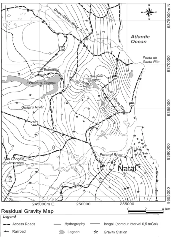
Two aspects are prevalent in the interpretation of the residual gravimetric map. The first is the occurrence of gravimetric highs and lows, with some in the form of extensive continuous surfaces, representing the structural internal highs and lows of the coastal basin, respectively. However, certain gravimetric highs do not fall, in principle, within the specific concept of internal structural high, that is, they do not fit the adopted interpretive model. This seems to be the case of the positive anomaly of 2.5 mGal east of Extremoz lake (Fig. 3). Such feature would be related to basic intrusions in the crust, such as that described by Rand & Manso (1990) for the Tabatinga beach latitude (approximately 25 km south of Natal), although the joint occurrence of horsts should not be ruled out in these sites. Another important feature concerns the gravimet-ric low of –3 mGal, immediately adjacent to the reported positive anomaly located southeast of the Extremoz lake. This gravimetric low shows the density contrast resulting from the increase of the sedimentary column in this structural block and is associated with the local graben configuration.
The sharp west-east gradient, with the isogalic curves ap-proximately parallel to the coastline, is caused by the decreasing depth of the Mohorovicic discontinuity close to the coast (Lucena,
“main” — 2013/11/13 — 23:29 — page 46 — #4
46
THE POTENTIAL OF THE BARREIRAS AQUIFER IN THE LOWER COURSE OF THE DOCE RIVER, RN, BRAZILFigure 2 – Residual gravity map of northern Natal, RN, including Doce River lower course. Contour interval: 1 mGal (modified from Duarte, 1995).
2005), and associated with the transition from the continental to oceanic crust. This gradient is locally very steep, considering that this region has a continental shelf of comparatively reduced width with respect to the southeastern and southern regions of Brazil, which masks the negative residual anomalies caused by the local sedimentary column. This aspect is well evidenced at Ponta de Santa Rita and to the south of the Potengi river mouth (Fig. 3).
The second important aspect of the residual map interpreta-tion involved the characterizainterpreta-tion of gravity alignments, defined based on isogalic continuity and/or limits between positive and
negative anomalies, and traced approximately around the edges of such anomalies. These alignments are configured according to the northwest and northeast directions, supporting the analy-sis of tectonic and structural framework predominant in the crys-talline basement and overlying Mesozoic sedimentary sequence. This assessment is supported by field observations in outcrops of crystalline basement to west and southwest of the area, as well as in studies involving branches of the Patos lineament on the coast of Rio Grande do Norte and Para´ıba States (Bezerra et al., 1994; Bezerra, 1998).
“main” — 2013/11/13 — 23:29 — page 47 — #5
LUCENA LRF, OLIVEIRA Jr JG, MEDEIROS WE & QUEIROZ MA
47
Figure 3 – Interpreted residual gravity map of northern Natal, RN, including Doce River lower course. Contour interval:
0,5 mGal (modified and interpreted from Duarte, 1995).
Regional Geological Context
Stratigraphically, the regional geology consists of two basic se-quences: first, the subsurface Precambrian crystalline basement and Mesozoic sedimentary units, both identified in regional geo-physical well logs. The second unit is represented by outcrops of Cenozoic sediments (Nogueira, 1982; Bezerra et al., 1993; Lu-cena, 2005). The latter includes clayey sands to conglomerates of the Barreiras Formation and sands of the Potengi Formation, below the quaternary sediments, which include beachrocks and several generations of mobile and fixed dunes.
Specific structural studies on the east coast of Rio Grande do Norte State date back to the 70s, including geophysical and lithological well correlation conducted by CAERN. These stud-ies showed tectonic reactivation, with gravity faults oriented in the northeast direction of the Potengi River estuary (delimiting the so-called Natal Graben) and northwest oriented structures in Parnamirim-RN (Parnamirim Graben). Similar results were ob-tained by Salim et al. (1974) while studying the occurrence of structural valleys on the east coast.
This structural pattern, with NE and NW faults, is consistent with later published works (Lucena & Queiroz, 1996; Bezerra,
“main” — 2013/11/13 — 23:29 — page 48 — #6
48
THE POTENTIAL OF THE BARREIRAS AQUIFER IN THE LOWER COURSE OF THE DOCE RIVER, RN, BRAZILFigure 4 – Geological sketch of the northern Natal, RN, including the lower Doce River area (TQb – Barreiras Formation;
Qp – Potengi Formation; Qdf – Fixed Dunes; Qdm – Mobile Dunes; Qbr – Beachrocks; Qa – alluvium and Qm – mangrove sediments).
1998; Coriolano et al., 1999; Nogueira et al., 2006). These struc-tures result in structural grabens and horsts that control the main valleys and the disposition of the quaternary stratigraphic units according to preferential directions. A brief morphotectonic anal-ysis of the lower course of Doce River, based in remote sensing and field investigation, revealed certain anomalies in the drainage network. The Doce River, starting at Extremoz lake, has at least two prominent deflections at 90◦angles, with drainage segments
that change direction abruptly from NE to SE, repeating the behav-ior of other river valleys on the east coast of Rio Grande do Norte State, clearly under structural control. Another important obser-vation is the presence of linear small water bodies and wetlands, located at 0.8 km to the northeast of the current Doce river chan-nel, although parallel to it, suggesting that the old course (paleo-channel) of Doce river underwent a drowning process, probably due to the migration of local dune fields, although it remained a signature of the SE direction in its low area, associated with the regional structures.
The integration of geological, geophysical and geomorpho-logical data (slopes and alignments of drainages and river val-leys) of previous studies is consistent with an extensional regime, where the main faults are classified as normal. The probable tran-scurrent components while incorporating almost all the specu-lation about the acting stress field have not yet been evaluated consistently as well as the variations of the stress field over geo-logic time. Figure 4 shows the regional geology summary of the study area.
Hydrogeological Context – The Barreiras Aquifer
The hydrogeological context consists of two zones, unsaturated and saturated, with water that is usually of excellent physico-chemical and bacteriological quality. The unsaturated zone is pre-dominantly represented by sandy sediments from the dunes and, secondarily, by the upper portion of Barreiras Formation. The sat-urated zone is represented mainly by the accumulation of water in the sediments of the lower portion of the Barreiras Formation. According to Melo (1995), such hydro-stratigraphic units to-gether form the single predominantly free Dunas-Barreiras Aquifer System, with localized semi-confinements.
This aquifer is responsible for the water supply of most coastal cities of Rio Grande do Norte State, including the capital Natal. Its lithology is quite diverse, ranging from clays to conglomeratic sandstones, although argillaceous sandstones predominate. The lower boundary of the aquifer is the top of the non-outcropping Mesozoic carbonate sequence in the region, which has been indi-vidualized in well drillings as consisting of sandy-clayey to sandy calcareous and low hydrogeological potential, or even the crys-talline basement in areas near the contact of the latter with the coastal sedimentary basin (Lucena & Queiroz, 1996; Lucena et al., 2004). Regarding hydrodynamics, the Barreiras aquifer also varies considerably, particularly in the southern region of Na-tal all the way to the border with Para´ıba State. The aquifer be-havior varies from free to semi-confined, with localized confine-ments where the semi-confining or confining layer, when present,
“main” — 2013/11/13 — 23:29 — page 49 — #7
LUCENA LRF, OLIVEIRA Jr JG, MEDEIROS WE & QUEIROZ MA
49
is represented by clay horizons or lenses of the BarreirasForma-tion itself (IPT, 1982).
The potentiometric map of the Doce river lower course area (Fig. 5) shows an underground main flow from SSW to NNE, reflecting ultimately, its minor influence, in terms of capacity to delineate the local hydrogeological sub-basin, when compared to the basins of Potengi (south) and Cear´a-Mirim (north) rivers. In this respect, it is remarkable the equipotential asymmetry on the margins of the Doce river, the right margin (extreme SW of the map) being the main recharge area. A secondary recharge zone is observed on the left margin of the river (east-central map), already in the context of the dune string area that represents the Environ-mental Protection Area (EPA) of Genipabu. This EPA is limited to the west by the RN-304 highway, to the east and north by the ocean and to the south by the Doce river (see Fig. 1). The regional discharge zone is the Cear´a-Mirim river (north), and a secondary discharge is found in the Doce river lower course area, starting at the Gramor´e lagoon. In addition, smaller hydraulic gradients and larger spacing of the equipotential surfaces in the east-central map indicate a more promising area in terms of hydraulic transmis-sivity, given by the inverse relationship of these two parameters (Feitosa et al., 2008). The density of the water points considered did not allow, however, configuring prominent hydrogeological dividers, including a possible divisor of the groundwater of the Barreiras Aquifer between the Doce River and Rio Cear´a-Mirim. The hydraulic gradients vary from 5 × 10⁻³(SW quadrant of the
map) to 2 × 10⁻³(east-central map), showing higher hydraulic
transmissivity on the left margin of Doce River (from the Doce River water capture of CAERN towards NE).
In general, the Barreiras Aquifer influences the whole surface hydric context, including local lakes. In the latter case, the dis-charge or underground contribution entering the left margin of the Gramor´e lake can be estimated (according to the potentiometric map of Fig. 5) by the expression of Eq. (1) (Feitosa et al., 2008):
Q = T × I × L (1) where:
T = hydraulic transmissivity; I = hydraulic gradient; L = water flow front.
By adopting a hydraulic transmissivity (T ) of 3.03 m2/h (according to CAERN capture production test of Doce River, Pt-47RDO), a hydraulic gradient (I) of 0.0025 and a water flow front (L) of 4,000 meters, the groundwater discharge entering the right margin of the Doce River is approximately 30.3 m3/h.
Figure 5 – Potentiometric map of Barreiras Aquifer in the lower Doce River area. Due to the lack of piezometers that would enable the aquifer tests, the reassessment on the left bank of the lower Doce River consisted of reevaluating four capture production tests previously performed by CAERN, of four tubular wells Pt-46 RDO, Pt-47 RDO, Pt-48 RDO and Pt-49 RDO with the following UTM coordi-nates 251219/9368396, 251043/9368556, 251584/9367087 and 251790/9367999, respectively (marked on the Gramor´e Lagoon left bank in Fig. 5). These 12” diameter wells were drilled from 07/12/04 to 06/04/05, coated with standard ribbed PVC pipes and filters (Pt-47 and Pt-49 RDO RDO) and stainless steel filters with 1-mm openings (PT-46 and PT-48 RDO RDO). The diameter of the pipes and filters was 8” for all wells. The tests lasted 12 hours and were performed using a submerged pump. The flow rates were measured as free discharge flow via a 200-liter barrel, while the water level measurements were made in relation to the mouths of the wells. The results of the tests are shown in Table 1.
Table 1 – Results obtained from CAERN pumping tests at the Doce
River production wells.
Well NE (m) ND (m) Q(m3/h) q(m2/h) Pt-46 RDO 29.60 32.30 45.00 16.69 Pt-47 RDO 30.50 35.01 48.00 10.65 Pt-48 RDO 29.75 34.25 49.66 11.03 Pt-49 RDO 29.10 39.12 39.56 3.95
“main” — 2013/11/13 — 23:29 — page 50 — #8
50
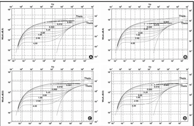
THE POTENTIAL OF THE BARREIRAS AQUIFER IN THE LOWER COURSE OF THE DOCE RIVER, RN, BRAZILFigure 6 – Drawdown curves and respective fittings, according to Neuman’s method, for the Doce River wells – CAERN (A–Pt-46 RDO, B–Pt-47 RDO, C–Pt-48 RDO
and D–Pt-49 RDO).
From these results, drawdown curves were constructed for each test and further adjusted according to methodology appro-priate to the local hydrogeologic environment. In this case, the Neuman’s method (Feitosa et al., 2008) provided the best fit to the drawdown curves (Fig. 6), assuming the aquifer in the area as free and of delayed drainage. The hydrodynamic parameters, obtained using the AquiferTest software, are summarized in Table 2.
These parameters, however, differ substantially from other values obtained by CAERN for producing wells on the right mar-gin of the lower Doce River, revealing how heterogeneous the two marginal plains of the aquifer are. Such heterogeneity must be credited to the tectonic-sedimentary evolution of the area. In this
respect, localized small grabens have been subjected to late eolian sedimentation after Cenozoic structural-tectonic events, with sub-sequent readjustment of local potentiometric loads. Thus, there are localized positive anomalies of hydraulic conductivity, which ultimately reflect also in elevated exploitable discharges. This ob-servation is supported by descriptions of well logs and drilling information, which showed the presence of thick layers of sand only in the aquifer, consistent with a eolian deposition in struc-tural lows and subsequent reworking. The changes in the lower Doce River, resulting from human activities (urbanization) coupled with the evolution of eolian sedimentation also corroborate this context. Contemporary remote sensing images reveal segments
Table 2 – Hydrodynamic parameters obtained from CAERN pumping tests at the Doce River production wells.
Wells T K Thickness Tm Km
(m2/min) (m/min) (m) (m2/min) (m/min) Pt-46 RDO 1.33 × 10⁻¹ 2.56 × 10⁻³ 52.00
7.397 × 10⁻² 1.634 × 10⁻³
Pt-47 RDO 5.05 × 10⁻² 1.17 × 10⁻³ 43.00
Pt-48 RDO 8.29 × 10⁻² 2.07 × 10⁻³ 40.00
“main” — 2013/11/13 — 23:29 — page 51 — #9
LUCENA LRF, OLIVEIRA Jr JG, MEDEIROS WE & QUEIROZ MA
51
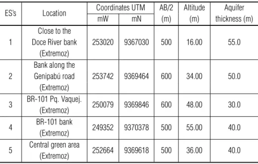
Table 3 – Electric sounding performed on the left margin of Doce River lower course.ES’s Location Coordinates UTM AB/2 Altitude Aquifer mW mN (m) (m) thickness (m) 1
Close to the
253020 9367030 500 16.00 55.0 Doce River bank
(Extremoz) 2
Bank along the
253742 9369464 600 34.00 50.0 Genipab´u road (Extremoz) 3 BR-101 Pq. Vaquej. 250079 9369846 600 48.00 30.0 (Extremoz) 4 BR-101 bank(Extremoz) 249352 9370378 500 55.00 40.0 5 Central green area(Extremoz) 252664 9369618 500 36.00 40.0 of abandoned river channels (with portions barred by dunes),
and the old river mouth located about 1 km to the north of the current location.
Electrical-Resistivity Geophysical Survey
A total of five electrical soundings were performed in the lower Doce River (Table 3), with 1.2-km maximum spacing of elec-trodes (AB/2 = 600 m). Altimetry values were determined by topographic field survey and GP. The indicated thickness results refers only to the aquifer and not the entire Tertiary-Quaternary sedimentary column.
In order to interpret the geoelectrical data, it is necessary to adopt a model consistent with the geological environment, which, in the study area is represented by approximately horizontal sed-imentary layers. In addition, the distances between the expres-sive horizontal discontinuities (faults) are much greater than the used maximum spacing between electrodes. Thus, the geoelec-trical model adopted has the following characteristics:
• The subsoil consists of a sequence of layers with finite thickness (Ei), except the last one, which is assumed as infinite;
• Each layer is assumed to be electrically homogeneous and isotropic, characterized by a resistivity (ρi);
• The separation interfaces between the layers are flat and horizontal, and parallel to the Earth surface.
The interpretation of the vertical electrical sounding (VES) experimental curve (ρa× AB/2) basically consists of obtaining numerical estimates of geoelectric parameters, in this case,
resis-tivity and thickness, for the flat and parallel layers model. The fit-tings between interpreted and acquired curves were made by trial and error, varying the parameters of the initially proposed model until a satisfactory fit was reached at the same time that known constraints were incorporated to the geoelectrical model.
Since there were no electrical well logs determining the
in situresistivity values of the local stratigraphic horizons, we performed calibration electrical soundings, adjacent to wells with known stratigraphic profiles. These VES were interpreted by fixing the layer thickness values (provided by lithological profiles) and estimating the resistivity, so as to adjust the curve using intervals of characteristic values (literature data) of the respective lithol-ogy (Silva & Medeiros, 1996). We used the geoelectric inversion WINSEV software for the VES interpretations, including the cali-bration electrical soundings. This software is based on the calcu-lation of theoretical curves using the methodology described by Mallick & Koefoed (1979).
The calibration (Fig. 7), located in the Sonho Verde lot area in Parnamirim-RN (UTM coordinates 250072 mW and 9341890 mN, about 25 km south of the study area) and adjacent to the recently drilled well, defined a bottom-up geoelectric stratigraphic model consisting of: limestone (referring to Cretaceous sedimentary basin), calcareous sandstone with resistivity of 30 .m., clayey sandstone turning to fine and coarse sandstone with resistivity of 180 and 500 .m, respectively, and sandy sediments with even-tual clay and humidity, with resistivity between 1200-5500 .m. The small total thickness variation of about 3 m (66 m in litholog-ical well profile and 63 m in the geoelectric interpretation) up to the top of the Mesozoic sequence (calcareous sandstone) can be explained by the fact that the sounding was not performed exactly on the well site, due to operational difficulties in the field.
“main” — 2013/11/13 — 23:29 — page 52 — #10
52
THE POTENTIAL OF THE BARREIRAS AQUIFER IN THE LOWER COURSE OF THE DOCE RIVER, RN, BRAZILFigure 7 – Calibration electrical sounding, with “thickness × resistivity” geoelectrical model and the lithological profile from the well in the Sonho
Verde area, Parnamirim, RN.
Figures 8-12 show the other soundings performed, includ-ing the geoelectrical models. Although the Cretaceous sequence limestone appears in the interpretation of some electrical sound-ings (resistivity of 800-1200 .m. at the base of the stratigraphic column), it was not adequately characterized since it requires greater electrode spacing (deeper penetration of electric current), and is not included in the goals of this research.
Figure 8 – Electric sounding 1 and its geoelectric model.
The Saturated Thickness Map
The interpretation and mathematical modeling of the geoelectric surveys, integrated with data from wells drilling the entire
Bar-reiras Formation, yielded a thickness map of the BarBar-reiras Aquifer on the left margin of the lower Doce river (Fig. 13). The information of wells used herein was obtained from the database of CAERN and Autonomous Service for Water and Sewage-SAEE (Health National Foundation – FUNASA/City Halls). Data distribution and origin are presented in Table 4. This punctual information, involv-ing XY coordinates (UTM) and their thickness values were inter-polated and gridded using the Surfer software (Golden Software) Kriging method.
Table 4 – Origin of the data used to produce the Barreiras Aquifer
satu-rated thickness map on the left margin of Doce River lower course.
Data/Origin Number of points Coastline
06 (zero saturated thickness)
Tubular wells 15 Electrical soundings 05
Total 26
The map of Figure 13 shows that the aquifer thickness varies between 30-35 m, mainly in the S-W sector, reaching about 60 m in the south-central sector. The well-defined E-W gradient noted in the eastern portion is due to the influence of the aquifer thick-ness values equal to zero taken along the coastline. The adop-tion of “zero” virtual values for the saturated thickness along the
“main” — 2013/11/13 — 23:29 — page 53 — #11
LUCENA LRF, OLIVEIRA Jr JG, MEDEIROS WE & QUEIROZ MA
53
Figure 9 – Electric sounding 2 and its geoelectric model. Figure 10 – Electric sounding 3 and its geoelectric model.
Figure 11 – Electric sounding 4 and its geoelectric model. Figure 12 – Electric sounding 5 and its geoelectric model. shoreline aimed to enhance the positive anomalies in the
inte-rior of the continent (by gridding and data interpolation), which constitute targets for water capture. In addition, it emphasizes the recommendation for not having high-flow producing wells near the sea due to the risk of salinization. Thus, the saturated thick-ness in this sector, also resulting from the interpolation and grid-ding of the source data must be viewed with reservations. Such variations in saturated thickness can also be viewed in the C-D hydrogeophysical section (Fig. 14), compiled from well log data (Pt-47RDO and Pt-49RDO) and SEVs (SEV 1 and 4).
DISCUSSION
The regional geology of the eastern coastal Natal reveals a lithos-tratigraphic context that consists, from bottom to top, of a Pre-cambrian crystalline basement, Mesozoic sedimentary basin de-posits, both non-outcropping sequences, in addition to all Ceno-zoic sedimentation. The latter outcropping throughout the study area, comprises the Barreiras Formation (Tertiary-Quaternary age)
and other Quaternary sedimentary units, composed by several generations of dunes and sandy covers and, alluvial and man-grove sediments. The tectonic and structural framework is formed by a complex regional structure, characterized in the main NW and NE directions. In this context, it is noteworthy that previous reported data show a correlation between a deep structure, sup-ported primarily by gravimetric surveys, and a shallower structure, defined by geoelectrical surveys, morphotectonic analysis, strati-graphic correlation in well log profiles and field investigations.
The analysis of the residual gravity field was used to define the gravity alignments, which are set by the continuity of equipo-tential lines and demarcation between local positive and negative anomalies. Except for possible intrusions of basic rocks, negative anomalies are associated with greater thickness of the sedimen-tary package, reflecting particularly on the Cenozoic sequence. The results were consistent with gravimetric surveys of adjacent areas where the NW and NE directions were also evident, and are associated with the current regional stress field, which deter-mines the maximum compression in the east-west direction and
“main” — 2013/11/13 — 23:29 — page 54 — #12
54
THE POTENTIAL OF THE BARREIRAS AQUIFER IN THE LOWER COURSE OF THE DOCE RIVER, RN, BRAZILFigure 13 – Barreiras Aquifer thickness map and the structural sketch of the lower Doce River area.
“main” — 2013/11/13 — 23:29 — page 55 — #13
LUCENA LRF, OLIVEIRA Jr JG, MEDEIROS WE & QUEIROZ MA
55
maximum strain in north-south direction (Ferreira, 1997; Bezerra,1998, Nogueira et al., 2010).
It can be suggested that the shallow structures are “rooted” in ancient and deep lineaments; considering that the fault dis-placements were determined by the correlation between well logs and vertical electrical soundings interpretation within the Ceno-zoic stratigraphy and the top of the non-outcropping MesoCeno-zoic sequence (carbonate rocks), as well as field investigations. Sim-ilarly, the faults are affecting the Cenozoic stratigraphic column and structurally conditioning river valleys (Doce River), and the morphotectonic (shallow crustal investigation) and the gravimet-ric (deep crustal investigation) alignments, are consistent with the reactivation of preexisting faults, rather than a strictly neo-formed structure. This regional strucutral re-activation becomes important since it strongly influences various hydrogeological as-pects, particularly the occurrence of positive anomalies of satu-rated thickness, resulting usually in locally high hydraulic trans-missivity of the Barreiras Aquifer, as shown in Table 2.
In this context, the aquifer thickness anomaly up to 60 meters in the south-central sector (Fig. 13) is associated with NW and NE trending gravimetric alignments, identified on the residual grav-ity anomaly of up to –3 mGal south of Gramor´e Lagoon (Fig. 3). In addition, morphotectonic alignments occur in the same direc-tions, and at least two coincide with gravimetric alignments, par-ticularly the NE trend that intersects the Gramor´e Lagoon and the other alignment immediately NE of the lagoon. The recognition of these faults resulted from the identification of subsurface dis-placements, which are enhanced in the hydrogeophysical section of Figure 14. This section shows the composition of a stepped fault system, where the greater thicknesses of the aquifer are associated with the negative displacement of the Mesozoic car-bonate sequence top.
It is noteworthy that the higher productivity of the wells should not be understood only as the result of saturated thick-ness increases, caused by local faulting. These positive changes in saturated thickness increase the capture probability of more hydraulically transmissive horizons, resulting from accumulation of sandy sediments, considering part of the regional tectonic-structural conditioning synchronous with the deposition of the Barreiras Formation (Lucena et al., 1999). The present local hy-drogeological characterization, although preliminary, suggests that the “saturated thickness” parameter would be more valuable than the hydrogeological parameters “Hydraulic conductivity and transmissivity”, when searching for the most promising capture areas. Although the latter reflects the influence of saturated thick-ness, it is routinely obtained from the aquifer testing as opposed
to positive changes of saturated thickness that can be determined with the help of existing well logs and geoelectrical surveys. It also emphasizes the direct proportional relationship between hydraulic transmissivity and transverse electrical resistance, considering a similar relationship between the hydraulic conductivity and resis-tivity in the saturated zone (Henriet, 1975; Griffiths, 1976).
Regarding other aspects of the area hydrogeological context, the potentiometry revealed an asymmetrical potential of the Doce River. The main recharge area is situated on the right margin of the drainage and the great discharge zone towards the lower Cear´a Mirim River. The greater distance between equipotentials, especially NE of Gramor´e Lagoon, reflects higher hydraulic trans-missivity also highlighted on the aquifer saturated thickness map (Fig. 13). A secondary recharge area is characterized in the center east of Figure 5, coincident with a local Environmental Protec-tion Area (EPA of Genipabu-RN), although it does not configure a flow converging to the Doce River lower course. This regional po-tentiometric setting reveals, ultimately, the low expression of the Doce River as hydrogeological sub-basin unit, when compared with the adjacent basins of the Potengi (south) and Cear´a-Mirim (north) Rivers. The main regional SSW to NNE flow increases, however, the risk of contamination of the left margin area of the river, since several producing wells located on the right margin have high nitrate levels, resulting from the infiltration of served water (poor sanitation system), plus chemical fertilizer used by the fruit and vegetable producers of the area.
The analysis and interpretation of CAERN capture production tests of the Doce River wells revealed transmissivity values from 1.33 × 10⁻¹to 8.29 × 10⁻²m2/min and hydraulic conductivity
from 1.77 × 10⁻³to 7.37 × 10⁻⁴m/min. These data, together
with the local potentiometry and saturated thickness map indicate an optimized location of a string of wells, aimed at increasing the water supply to northern Natal, approximately parallel to the cur-rent Doce River capture, displaced about 1 km towards E-NE.
CONCLUSIONS
The integration of shallow and deep geophysical data in the hy-drogeological context of the Barreiras Aquifer was very effec-tive in developing a local hydrogeological conceptual model that emphasized the geometry of the aquifer. The regional structure reported herein, whether modern or from reactivated ancient and deep lineaments was determinant in the aquifer compartmental-ization, especially by defining the positive thickness anomaly of Barreiras Aquifer of up to 60 meters in the vicinity of Gramor´e Lagoon. In this respect, there was a similarity between some
“main” — 2013/11/13 — 23:29 — page 56 — #14
56
THE POTENTIAL OF THE BARREIRAS AQUIFER IN THE LOWER COURSE OF THE DOCE RIVER, RN, BRAZIL gravimetric alignments (deep investigation) and localmorpho-tectonic alignments (shallow investigation), indicating that this saturated thickness anomaly resulted from the kinematic evolu-tion of deeper structures (rooted) in the basement. This struc-tural kinematic evolution led, ultimately, to the delineation of more promising subareas in terms of hydraulic transmissivity, taking as reference the aquifer thickness and assuming an average hydraulic conductivity representative of the left margin area of the Doce River (about 1.63 × 10⁻³m/min for the CAERN capture in
the Doce River). Thus, it is noteworthy that the electrical resistiv-ity survey has confirmed to be an essential prospecting method-ology, to determine the top and bottom of the Barreiras Aquifer since the saturated thickness parameter prevails at the expense of other hydrogeological parameters obtained for the same location. Future well locations on the left margin of the Doce River should prioritize the interception of the reported geological/hy-drogeological feature, even more due to the proximity of a sec-ondary recharge zone. This determines a zone roughly parallel to the current Doce River capture and displaced about 1 km to-wards E-NE.
Given the results of this research, the first of the new water captures drilled by CAERN in January 2009 with 8” pipe, located within the selected area of saturated thickness positive anomaly (indicated by the dashed line NE of the Gramor´e Lagoon), gave a specific flow of 14 m2/h, with recommended exploitable flow of 100 m3/h. Such values result in a total discharge estimative of
not less than 300 m3/h for all four wells.
ACKNOWLEDGMENTS
The authors thank the Companhia de ´Aguas e Esgotos do Rio Grande do Norte – CAERN for funding this project and for ap-preciating research as a tool in the decision making process concerning the management of water resources. Leandson R.F. Lucena and Walter E. Medeiros are also thankful to CNPq for their research grants.
REFERENCES
ASTIER JL. 1975. Geofisica aplicada a la hidrogeologia. Ed. Paraninfo. Madrid, 344 pp.
BALSAMO F, STORTI F, SALVINI F, SILVA AT & LIMA CC. 2010. Structural and petrophysical evolution of extensional fault zones in low-porosity, poorly lithified sandstones of the Barreiras Formation, NE Brazil. Journal of Structural Geology, 32: 1806–1826.
BELTR˜AO JF, SILVA JB & COSTA JC. 1991. Robust polynomial fitting method for regional gravity estimation. Geophysics, 56(1): 80–89.
BEZERRA FHR. 1998. Neotectonics in Northeastern Brazil. Ph.D. Thesis, University of London. 208 pp.
BEZERRA FHR, SAAD A, MOREIRA JAM, LINS FAPL, NOGUEIRA AMB, MACEDO JWP, LUCENA LRF & NAZAR´E Jr D. 1993. Estruturac¸˜ao neo-tectˆonica do litoral de Natal-RN, com base na correlac¸˜ao entre dados geol´ogicos, geomorfol´ogicos e gravim´etricos. Proceedings IV Simp´osio Nacional de Estudos Tectˆonicos, Boletim 12, p. 317-321, Belo Hori-zonte, MG.
BEZERRA FHR, ACCIOLY PCV, MACHADO MF, DUARTE MIM, ARA ´UJO MAT & AMARO VE. 1994. Correlac¸˜ao preliminar entre estruturas do embasamento cristalino e da faixa sedimentar costeira oriental do RN/PB. Proceedings XXXVIII Congresso Brasileiro de Geologia, Boletim de Resumos Expandidos, p. 562-563, Cambori´u, SC.
CASTANY G. 1975. Prospecci´on y explotaci´on de las aguas sub-terr´aneas. Ed. Omega. Barcelona, 738 pp.
CORIOLANO ACF, LUCENA LRF, JARDIM DE S´A EF & SAAD A. 1999. A deformac¸˜ao quatern´aria no litoral oriental do Rio Grande do Norte. Proceedings VIII Simp´osio Nacional de Estudos Tectˆonicos, p. 67–70, Lenc¸´ois, BA.
CPRM – SERVIC¸O GEOL´OGICO DO BRASIL. 2006. Mapa geol´ogico do Estado do Rio Grande do Norte. Servic¸o Geol´ogico do Brasil, Superin-tendˆencia Regional de Recife, 1 mapa geol´ogico, escala 1:500.000. DUARTE MIM. 1995. Mapeamento geol´ogico e geof´ısico do litoral leste do RN: Grande Natal (´area I). Relat´orio de Graduac¸˜ao, Departamento de Geologia, Universidade Federal do Rio Grande do Norte, 58 pp. FEITOSA FAC, MANUEL FILHO J, FEITOSA EC & DEMETRIO JCA. 2008. Hidrogeologia – conceitos e aplicac¸˜oes. Organizac¸˜ao e coordenac¸˜ao cient´ıfica CPRM: LABHID, 3 ed. rev. e ampl. Rio de Janeiro. 812 pp. FERREIRA JM. 1997. Sismicidade e esforc¸os no Nordeste do Brasil. S˜ao Paulo. Doctorate Thesis, Instituto de Astrof´ısica e Geologia, Universidade de S˜ao Paulo. 126 p.
GRIFFITHS DH. 1976. Application of electrical resistivity measurements for the determination of porosity and permeability in sandstones. Geo-exploration, 14(3-4): 207–213.
HENRIET JP. 1975. Direct applications of the Dar Zarrouk parameters in ground water surveys. Geophysical Prospecting, 24: 344–353. IPT – INSTITUTO DE PESQUISAS TECNOL´OGICAS DO ESTADO DE S˜AO PAULO S/A. 1982. Natal, SIC-Gov/RN. Estudo hidrogeol´ogico regional detalhado do Estado do Rio Grande do Norte. Relat´orio t´ecnico IPT no. 15.795, 389 pp.
KIRSCH R. 2006. Groundwater Geophysics, a tool for hydrogeology. Springer, Berlin, 493 pp.
KOEFOED O & MALLICK K. 1979. Geosounding principles: resistivity sounding measurements. Elsevier Publ. Co, Amsterdam, 276 pp.
“main” — 2013/11/13 — 23:29 — page 57 — #15
LUCENA LRF, OLIVEIRA Jr JG, MEDEIROS WE & QUEIROZ MA
57
LUCENA LRF. 2005. Implicac¸˜ao da compartimentac¸˜ao estrutural noAqu´ıfero Barreiras na ´area da bacia do Rio Pirangi-RN. Doctorate The-sis, Universidade Federal do Paran´a, 151 pp.
LUCENA LRF & QUEIROZ MA. 1996. Considerac¸˜oes sobre as influˆen-cias de uma tectˆonica cenoz´oica na pesquisa e prospecc¸˜ao de recursos h´ıdricos – o exemplo do litoral sul de Natal-RN, Brasil. Revista ´Aguas Subterrˆaneas, 15: 81–88.
LUCENA LRF, OLIVEIRA SK & MEDEIROS WE. 1999. Condicionamento estrutural sobre o Aqu´ıfero Barreiras e Sistema Lacustre do Bonfim, N´ısia Floresta-RN. Proceedings VI International Congress of the Brazilian Geophysical Society, 1 CD-ROM, Rio de Janeiro, RJ.
LUCENA LRF, ROSA FILHO EF & BITTENCOURT AVL. 2004. A poten-ciometria do Aqu´ıfero Barreiras no setor oriental da bacia do Rio Pi-rangi-RN e considerac¸˜oes sobre a relac¸˜ao com mananciais superficiais. Revista ´Aguas Subterrˆaneas, 18: 19–27.
LUCENA LRF, ROSA FILHO EF & HINDI EC. 2006. O controle estrutural no Aqu´ıfero Barreiras – ´area da bacia do Rio Pirangi-RN. Revista ´Aguas Subterrˆaneas, 20: 83–98
MEDEIROS WE & SILVA JBC. 1996. Geophysical inversion using ap-proximate equality constraints. Geophysics, 61: 81–88.
MELO JG. 1995. Impactos do desenvolvimento urbano nas ´aguas sub-terrˆaneas de Natal/RN – Zona Sul. Doctorate Thesis, Universidade de S˜ao Paulo, 196 pp.
NOGUEIRA AMB. 1982. O Cenoz´oico continental da regi˜ao de Natal-RN. Master Dissertation, Universidade Federal de Pernambuco, 219 pp. NOGUEIRA FCC, BEZERRA FHR & CASTRO DL. 2006. Deformac¸˜ao r´uptil em dep´ositos da Formac¸˜ao Barreiras na porc¸˜ao leste da Bacia Potiguar. Geologia USP S´erie Cient´ıfica, 6(2): 51–59.
NOGUEIRA FCC, BEZERRA FHR & FUCK RA. 2010. Quaternary fault kinematics and chronology in intraplate northeastern Brazil. Journal of Geodynamics, 49: 79–91.
ORELLANA E. 1972. Prospeci´on geoel´etrica en corriente continua. Ed. Paraninfo. Madrid, 523 pp.
RAND HM & MANSO VAV. 1990. Mapas gravim´etricos e magne-tom´etricos da faixa costeira do Nordeste do Brasil. Proceedings XXXVI Congresso Brasileiro de Geologia, 5: 2431–2438, Natal, RN.
RODRIGUES MAC, LUCENA LRF & SOUZA IVF. 2011. Preliminary geo-metric model of the Barreiras Aquifer derived from hydrogeophysics data at the Catu basin, NE Brazil. In: International Congress of the Brazilian Geophysical Society, 12., 2011, Rio de Janeiro. Proceedings... Rio de Janeiro: SBGf, 2011. CD-ROM.
RUBIN Y & HUBBARD SS. 2005. Hydrogeophysics. Springer, Dordrecht, The Netherlands, 521 pp.
SALIM J, LIMA MS & MABESOONE JM. 1974. Vales estruturais no litoral leste do Rio Grande do Norte. Proceedings VI Simp´osio de Geo-logia do Nordeste, p. 41-47, Macei´o, AL.
Recebido em 28 julho, 2011 / Aceito em 30 julho, 2012 Received on July 28, 2011 / Accepted on July 30, 2012
NOTES ABOUT THE AUTHORS
Leandson Roberto Fernandes de Lucena. Graduated in Geologia (UFRN, 1993), has a master’s degree in Geophysics (PPGG/UFRN, 1999) and Doctor in
Exploratory and Environmental Geology (UFPR, 2005). Currently, is a Professor at the Department of Geophysics of the UFRN and Researcher 2 of CNPq.
Josibel de Oliveira Gomes Junior. Graduated in Physics (UFRN, 1998), has a master’s degree in Geophysics (PPGG/UFRN, 2001) and Doctor in Geophysics
(PPGG/UFRN, 2006). Currently, is a Professor at the Department of Geophysics of the UFRN.
Walter Eugˆenio de Medeiros. Graduated in Civil Engineering (UFRN, 1981), has a master’s degree in Geophysics (UFBA, 1987) and Doctor in Geophysics
(UFPA, 1993). Currently, is a Professor at the Department of Geophysics of the UFRN, Researcher 1A of CNPq and member of the editorial board of the Brazilian Journal of Geophysics (Revista Brasileira de Geof´ısica).
Marcelo Augusto de Queiroz. Graduated in Geology (UFRN, 1984). Hydrogeologist of the Hydrogeology and Well Drilling Management of the Companhia de