DYNAMICS OF BRÂGLEZ
RIVERBED (SOMEŞAN PL
ATEAU)
GH. ROŞIAN1
, L. MUNTEAN1, V. MĂCICĂŞAN1, R. RUSU2, V. ARGHIUŞ1
ABSTRACT. – Dynamics of Brâglez Riverbed (Someşan Plateau). The main left tributaries of Someş along Surduc – Jibou sector (Brâglez, Almaş and Agrij), are characterized by the presence of obvious processes of lateral and vertical erosion at the level of the riverbeds. The field observations, as well as the position of these rivers and their catchment areas in the neighborhood of the lower Someş subsidence area, would easily be grounds for explaining the riverbed processes as caused by an unstable fluvial base level. More precisely, this base level would be moving downwards under the influence of subsidence movements of Tisa Plain or even because of the subsidence affecting Guruslău Basin. Starting from these more or less speculative deductions, this paper aims at checking and confirming the above-mentioned explanations or finding other causes for the dynamics of riverbed processes. In this sense, we analysed a correlation between the drainage in the catchment area and at the level of the riverbeds, on one hand, and the riverbed geomorphological processes, on the other hand. Brâglez River (in western Someşan Plateau) will be considered as a study case, as it provides an accelerated dynamics of riverbed processes. This situation will be compared with the one in the eastern part of the same plateau, where rivers like Borşa, Luna or Lujerdiu do not present obvious riverbed processes despite the similar climatic and geological conditions.
Keywords: drainage basin, base level, average runoff, erosion.
1. INTRODUCTION
Within the territorial units which morphologically are the result of fluvial modeling, there are two sections where geomorphological processes are active: the section at the level of slopes and the section at the level of riverbeds. This fact is also specific for the different territorial units of the Transylvanian Basin. This study focuses on the current situation in the case of the left tributaries of Someş between Surduc and Jibou.
In this context, the left tributaries of Someş along the above-mentioned sector (Brâglez, Almaş and Agrij) are characterized by the presence of obvious processes of lateral and vertical erosion at the level of the riverbeds. The position of these rivers in the proximity of the subsidence area of lower Someş drainage basin may be considered as a reason for the dynamics of their riverbeds. Starting from these deductions, this paper aims at checking the influence of other variables that might be involved in the development of riverbed specific processes. This
1 ”Babeş-Bolyai” University, Faculty of Environmental Science and Engineering, Fântânele Street, No. 30, 400294 Cluj-Napoca, Cluj County, Romania, e-mail: [email protected]
2”Babeş
includes a correlation between the liquid average runoff in the catchment area and at the level of riverbeds, on one hand, and the geomorphological processes specific for riverbeds, on the other hand. The analysis will focus on Brâglez River as a case study. This stream is located in the western part of Someşan Plateau. Its situation from the point of view of riverbed dynamics and runoff will be compared to the one existing in the riverbeds of the eastern part of the same plateau, where rivers like Borşa, Luna or Lujerdiu present a low dynamics of riverbed processes despite the similar climatic and geological conditions. Depending on the outcome, resulted from the analysis of runoff values, one may state more exactly if the dynamics of Brâglez River and its neighbouring streams is the consequence of an unstable base level or, on the contrary, it is the result of the amount of water drained through the riverbeds and at the level of the catchment area.
2. MORPHODYNAMICS OF BRÂGLEZ RIVERBED
Brâglez catchment area covers 109 km2 and is included regionally in the unit known as Gârbou Hills (Şimişna – Gârbou Hills) (Geografia României, III, 1987) or Şimişna – Surduc Hills, part of Someşan Plateau (Gr. Pop, 2001). It is located in the north-western extremity of this unit (fig. 1).
Geologically, most of the catchment area corresponds to Miocene (Ottnangian) formations, except for the northern half of the middle sector where Eocene limestones and Oligocene formations are also found.
In this paper, Brâglez River morphodynamics will be assessed along Gârbou – Surduc sector. This is 15.5 km long and corresponds to the medium sector (until the narrowing at Fabrica) and the lower sector (between Fabrica and the confluence with Someş at Surduc). Although the narrowing at Fabrica is obvious at the level of the corridor in a cross section, it makes no significant difference for the riverbed gradient.
The low thalweg gradient (0.32o) and the presence of alluvial deposits, together with other factors, led to the development of a meandered riverbed, with values of the meandering ratio of more than 1.5 along some parts of the lower sector.
Brâglez riverbed between Gârbou and Surduc has a variable width (15 – 70 m), banks with moderate heights of 0.5 to 1.8 m and complex microforms represented by microbars and abandoned microchannels. The connection between the riverbed and the floodplain is usually performed by means of steep banks, resulted from lateral erosion. The meandered channel of Brâglez determines an alternation of sectors with steep banks, accompanied by overhangs, and sectors with weakly inclined banks in the convex bends of the meanders.
discharge is recorded in spring (March – May), while the lowest one in autumn (September – October). Depending on the amount of precipitation and the sudden melting of snow, flash floods may occur in any season. The runoff regime influences the water level oscillations, which have a direct impact on the acceleration of lateral erosion and the changes occurred in the morphology of the alluvial bed. The most efficient bank erosion takes place at high waters, when the erosive capacity of the river over the banks increases significantly.
Fig. 1. Territorial position of Brâglez catchment area
From the point of view of the dynamics of riverbed processes, the specificity is given by the lateral river erosion. Its result is materialized in the accelerated recession of banks. This has an impact on the floodplain, as it becomes narrower and sometimes has the aspect of a terrace fragment. In the cases when the floodplain has been completely eroded, morphodynamic relations of cooperation are set up, as it happens on the right side of the river, downstream of Gârbou and on the left side, upstream of Fabrica.
on the floodplain surface. Although these measurements have been made expeditiously, the results are presented in table 1.
Table 1. Values of measurements performed within the control sections
Section
Time interval
April 15, 2006 – November 25, 2006 November 25, 2006 – April 16, 2007 Left bank Right bank Left bank Left bank I (downstream
of Gârbou)
Recession 0.5 m Recession 0.3 Recession 0.4 Recession 0.2
II (downstream of Fabrica)
Aggradation Recession 1.1 m Aggradation 0.4 m
III (downstream of Brâglez)
Recession 0.5 m Recession 0.8 m Recession 0.7 Recession 0.4
The first section is located downstream of Gârbou, more precisely 30 m downstream from the bridge over Brâglez. The recession process is characteristic for both banks and it is more intense between April and November.
The second section is very visible in the field and lies immediately
downstream of Fabrica village. The highly intensive erosion process is present only on the right bank.
The third section is located approximately 1 km downstream of Brâglez village, at the mouth of Drojdii rivulet. The erosion process is specific for both banks and it is more intense between April and November. The right bank erosion affects the road linking Surduc and Gârbou, reaching almost the road axis (Roşian, 2011).
The analysis of the results for every section and the field observations confirm the generalization of the bank recession processes in the presence of meander bends, when the concave bank is affected, but also in the their absence, when both banks are affected, either at the same time or one after the other.
Apart from lateral erosion, there is also headward erosion. However, due to the instability of the alluvial bed consisting of gross gravel, it is not representative for the small time interval when bank erosion processes have been assessed.
3. THE AVERAGE WATER LAYER RUNOFF IN BRÂGLEZ CATCHMENT AREA
Of the ways to express the average runoff at the level of a catchment area (the multiannual average discharge, the volume of average runoff, the specific average runoff, the height of the average runoff, the discharge ratio, the runoff ratio) the average water layer runoff (or height of the average runoff) has been selected in this case. This indicator has been chosen because it represents the thickness of a water layer uniformly distributed across the entire catchment area. It results by dividing the volume of runoff water within a given period (usually a year) to the catchment area where it comes from (table 2).
point of view of riverbed dynamics. This fact has been taken into consideration starting from the idea that the volume of water flowing through a riverbed during a certain time interval is strictly connected to the water layer flowing at the level of the considered catchment area (Sorocovschi, Horvath, Bilaşco, 2009).
Table 2. The values of multiannual average runoff
Catchment area
Area F (km2)
Discharge Q (m3/s)
Volume V (mil. m3)
Runoff q (l/s . km2)
Average runoff (mm)
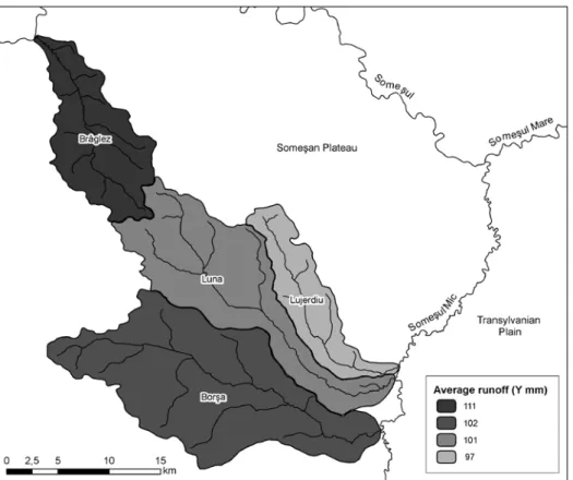
Brâglez 109 0.388 12.2 3.53 111
Borşa 265 0.864 27.2 3.26 102
Luna 177 0.574 18.1 3.23 101
Lujerdiu 73 0.228 7.2 3.10 97
For the above-mentioned indicator, the value of 111 mm has been computed for Brâglez basin by dividing the volume of runoff water to the catchment area. Using the same methodology for the catchment areas of the eastern part of Someşan Plateau, the following values have been obtained (fig. 2): 102 mm (Borşa), 101 mm (Luna) and 97 mm (Lujerdiu).
The values of the average water layer runoff for the above-mentioned catchment areas allow the highlighting of differences and are useful for performing correlations between runoff and the dynamics of riverbed geomorphological processes.
4. CONCLUSIONS
This paper aimed at explaining the accelerated dynamics of riverbed processes specific for Brâglez River (located in the north-western part of Someşan Plateau) and its neighbouring streams (Almaş, Agrij), compared to the existing situation in the case of rivers of the eastern and south-eastern part of the same territorial unit (Borşa, Luna, Lujerdiu).
From the analysis of the results concerning runoff in table 2, it comes out that both the specific average runoff as well as the water layer runoff have higher values in the case of Brâglez catchment area. It means that the variable which determines differences in riverbed processes between the western and eastern part of Someşan Plateau is related to the runoff at the level of catchment areas of the above-mentioned rivers.
As a result, it is not indicated to stress the role of a decreasing base level, as this is case of Someş in its lower sector, to explain the dynamics of riverbed processes. Of course, this plays an important part, but the variable which dictates such differences is the runoff within the catchment areas, its balance and, linked to it, the discharges of the riverbeds, connected to the area of the drainage basin. This outcome may be confirmed or disconfirmed by further studies which may also consider other variables.
REFERENCES
1. Pop, Gr. (2001), Depresiunea Transilvaniei,Editura Presa Universitară Clujeană,
Cluj-Napoca.
2. Roşian, Gh. (2011), Modele de geomorfologie funcţională ale sistemului vale -versant din Depresiunea Transilvaniei, Editura Presa Universitară Clujeană, Cluj -Napoca.
3. Sorocovschi, V., Horvath, Cs., Bilaşco, Şt. (2009), Water Balance in the
Southern Part of Someşan Plateau, Studia Universitaatis Babeş-Bolyai, Seria
Geographia, LIV, 79-88.