www.atmos-meas-tech.net/6/1/2013/ doi:10.5194/amt-6-1-2013
© Author(s) 2013. CC Attribution 3.0 License.
Measurement
Techniques
Detection and characterization of heavy drizzle cells within
subtropical marine stratocumulus using AMSR-E 89-GHz
passive microwave measurements
M. A. Miller and S. E. Yuter
North Carolina State University, Department of Marine, Earth, and Atmospheric Sciences, Campus Box 8208, Raleigh, NC 27695, USA
Correspondence to:M. A. Miller ([email protected])
Received: 2 May 2012 – Published in Atmos. Meas. Tech. Discuss.: 2 July 2012
Revised: 16 November 2012 – Accepted: 19 November 2012 – Published: 2 January 2013
Abstract. This empirical study demonstrates the feasi-bility of using 89-GHz Advanced Microwave Scanning Radiometer–Earth Observing System (AMSR-E) passive mi-crowave brightness temperature data to detect heavily driz-zling cells within subtropical marine stratocumulus. For the purpose of this paper, we define heavily drizzling cells as areas≥6 km×4 km with C-bandZ >0 dBZ; equivalent to
>0.084 mm h−1. A binary heavy drizzle product is described that can be used to determine areal and feature statistics of drizzle cells within the major marine stratocumulus re-gions. Current satellite liquid water path (LWP) and cloud radar products capable of detecting drizzle are either lack-ing in resolution (AMSR-E LWP), diurnal coverage (MODIS LWP), or spatial coverage (CloudSat). The AMSR-E 89-GHz data set at 6 km×4 km spatial resolution is sufficient for resolving individual heavily drizzling cells. Radiant emis-sion at 89 GHz by liquid-water cloud and precipitation par-ticles from drizzling cells in marine stratocumulus regions yields local maxima in brightness temperature against an oth-erwise cloud-free background brightness temperature. The background brightness temperature is primarily constrained by column-integrated water vapor for moderate sea surface temperatures. Clouds containing ice are screened out. Once heavily drizzling pixels are identified, connected pixels are grouped into discrete drizzle cell features. The identified drizzle cells are used in turn to determine several spatial statistics for each satellite scene, including drizzle cell num-ber and size distribution. The identification of heavily driz-zling cells within marine stratocumulus regions with satellite data facilitates analysis of seasonal and regional drizzle cell
occurrence and the interrelation between drizzle and changes in cloud fraction.
1 Introduction
Marine stratocumulus clouds cover vast regions of the east-ern subtropical oceans and are a source of net cooling in the Earth’s radiation budget (Hartmann et al., 1992). The ra-diative characteristics of marine stratocumulus are closely tied to cloud fraction, which differs dramatically between regions of continuous unbroken cloud versus regions with mesoscale pockets of open cells (Stevens et al., 2005). Ob-servational and modeling studies have implicated heavy driz-zle cells in the transitions between closed- and open-cell mesoscale cloud structures (Stevens et al., 2005; van Zan-ten and Stevens, 2005; Comstock et al., 2007; Savic-Jovic and Stevens, 2008; Wang and Feingold, 2009; Wood et al., 2011a). These studies suggest that drizzle is a necessary but not sufficient condition for the formation of pockets of open cells. The spatial and temporal distributions of drizzle within marine stratocumulus clouds are hence key parameters of interest.
using 85.5 GHz data from Special Sensor Microwave Imager (SSM/I) to estimate LWP as a function of the normalized polarization difference (Petty and Katsaros, 1990, 1992). This method was devised for general precipitation cases and was specific to SSM/I sensors. The Petty method also required an estimation of hypothetical clear-sky brightness temperature values. The calculation of clear-sky values can be challenging for regions of broad cloudiness, like stratocu-mulus regions, without relying on climatology data or data from multiple sensor platforms. Crewell and Lˇohnert (2003) used vertically pointing (upward) 90 GHz radiometer data to improve the accuracy of retrieved LWP of cloud liquid water and drizzle.
In the absence of ice, satellite-observed 89-GHz brightness temperatures are the net result of column-integrated emission and scattering of upwelling radiation by the ocean-surface, water vapor, and liquid hydrometeors. The variances in ob-served brightness temperature are primarily a function of the background ocean-surface emission (primarily related to sea surface temperature – SST – and wind speed), gas absorp-tion, water vapor profile, beam filling, and LWP, including cloud and precipitable water (Westwater et al., 2001; Crewell and Lˇohnert, 2003; Greenwald et al., 2007; Horv´ath and Gen-temann, 2007; Greenwald, 2009). Of these sources of emis-sion, we expect that LWP will have the largest variance at spatial scales on the order of individual drizzle cells within marine stratocumulus.
A new satellite-based method to document drizzle cell oc-currence within marine stratocumulus clouds can comple-ment existing satellite observations, each of which has limi-tations. The key limitation of the Moderate Resolution Imag-ing Spectroradiometer (MODIS) Cloud Liquid Water Path product (King et al., 2003) is that it requires information from MODIS visible wavelength channels and is not avail-able at night. For the purposes of this study, we refer to the MODIS Cloud Water Path as LWP. For stratocumulus ob-servations, the two parameters should be the same and we use the terms interchangeably. While drizzle does occur in marine stratocumulus regions during daylight hours, more frequent and intense marine stratocumulus drizzle typically occurs at night when LWP values are higher (Bretherton et al., 2004; Comstock et al., 2005; Sharon et al., 2006). Any method attempting to ascertain the regional characteristics of drizzle while excluding nighttime drizzle would miss the mode of the drizzle cell distribution and hence would not pro-duce a robust representation of regional drizzle characteris-tics. Current passive microwave LWP products (Wentz and Meissner, 2000, 2004; Kida et al., 2009) have too coarse a spatial resolution (14 km×8 km) to adequately resolve small and intense drizzle cells, which are typically 1–10 km in hori-zontal dimension. The CloudSat radar (Stephens et al., 2002, 2008; Haynes and Stephens, 2007) has a minimum sensi-tivity of −28 dBZ and provides information on the verti-cal structure of clouds. CloudSat observations of cloud-top heights and the profile of reflectivity are important physical
characteristics of marine stratocumulus. However, Cloud-Sat’s swath width of 1.4 km is not adequate to obtain infor-mation on the horizontal mesoscale organization of drizzle. The Tropical Rainfall Measuring Mission (TRMM) satel-lite’s Precipitation Radar can only detect the very strongest drizzle cells that have radar reflectivities above the radar’s minimum sensitivity of 17 dBZ at 5 km×5 km spatial reso-lution (Kummerow et al., 1998).
The goal of this study is to use empirical data to demon-strate the feasibility of using 89-GHz Advanced Microwave Scanning Radiometer–Earth Observing System (AMSR-E) (Kawanishi et al., 2003) passive microwave brightness tem-perature data (Ashcroft and Wentz, 2006) to detect heavily drizzling cells within marine stratocumulus. A binary heavy drizzle classification product is described that can be used to determine areal and feature statistics of drizzle cells within major marine stratocumulus regions.
2 Methodology
2.1 Motivation
The Variability of the American Monsoon System (VA-MOS) Ocean-Cloud Atmospheric-Land Study (VOCALS) Regional Experiment (REx) (Wood et al., 2011b), which took place in the southeastern Pacific Ocean during Octo-ber and NovemOcto-ber 2008, provided an opportunity for the in-tercomparison of satellite- and surface-based measurements of marine stratocumulus clouds and drizzle. The C-band wavelength radar on the National Oceanic and Atmospheric Administration (NOAA) ship Ronald H. Brown scanned a 120-km-diameter circle centered on the ship with a mini-mum sensitivity of radar reflectivity≈0 dBZ. The mesoscale structures of heavy drizzle in the region scanned by the radar can be compared to those retrieved by various satellite algorithms.
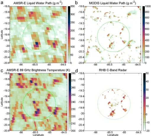
Figure 1 shows collocated observations near 21◦
S and 85◦
W within the southeast Pacific stratocumulus region from MODIS LWP, AMSR-E LWP (Wentz and Meissner, 2000, 2004), AMSR-E 89-GHz horizontally polarized (H) bright-ness temperature (T89H), and NOAA ship radar’s C-band radar reflectivity. The horizontally polarized 89-GHz bright-ness temperature channel is used in this study because it contains less noise than the vertically polarized channel. There is also a larger dynamic range of surface emissivities for horizontal polarizations in the microwave band, which allows for better resolving of surface features (Jones and Vonder Haar, 1997). In Fig. 1d, cells with radar reflectivi-ties (Z) greater than 0 dBZ indicate the presence of heavy drizzle. The MODIS LWP data clearly capture these heav-ily drizzling cells, which are characterized by LWP values
Fig. 1.Detailed comparison among(a)AMSR-E LWP,(b)MODIS Level 2 Cloud Water Path,(c)AMSR-E Level 2 89-GHz brightness temperature, and(d)C-band ship-borne radar reflectivity data (dBZ) obtained at 19:36 UTC on 27 October 2008 in the southeast Pacific during VOCALS experiment. The 60 km radius range ring from the radar is overlaid on each image. In order to highlight gradients in LWP, the dynamic range of the color scales differs between(a)and(b).
algorithm described in this paper stems from the observations in Fig. 1c. Drizzle cells corresponding to those observed by the C-band radar are evident as distinct local maxima inT89H(Fig. 1c). Since strong drizzle cells withZ >0 dBZ are usually between 1 and 10 km in scale, these features are more distinct in the finer-resolutionT89Hdata at 6 km×4 km spatial resolution compared with the AMSR-E LWP prod-uct at 14 km×8 km. The disadvantage of an 89-GHz–based method is that it will not work where clouds containing ice are present. The inversion-topped boundary layers in the sub-tropical regions constrain marine stratocumulus cloud-top al-titudes to well below the 0◦
C level,precluding the existence of drizzling clouds containing ice, and making these clouds a prime candidate for the exploitation of 89-GHz emission. Within marine stratocumulus regions characterized by strong inversions, any middle level or high level ice clouds can be easily distinguished from liquid-phase clouds by their cloud-top temperatures.
2.2 Binary heavy drizzle cell classification algorithm
For the purpose of this paper, we define heavily driz-zling cells as areas≥6 km×4 km with C-bandZ >0 dBZ.
Using the cloud base Z–R relationship from Comstock et al. (2004), 0 dBZ is equivalent to 0.084 mm h−1. C-band
89 GHz H Brightness Temperature (K)
IWV vs. 89 GHz H − Cloud−Free AMSR−E Observations
0 10 20 30 40 50 60
150 200 250 300 0 100 200 300 400 500 600 700 800 5 5 5 5 5 5 5 5 5 5 5 5 5 5 5 5 5 5 5 5 5 5 5 5 5 5 5 5 5 10 10 10 10 10 10 10 10 10 10 10 10 1010 10 10 10 10 10 25 25 25 25 25 25 25 25 50 50 50 50 50 100 100 100 200 200 400 600 800 1000 1200
Integrated Water Vapor (kg m-2)
89 GHz Brightness Temperature (K)
IWV vs Tb89h - Stratocumulus Regions
0 10 20 30 40 50 60
150 200 250 300 100 200 300 400 500 600 700 800 900 1000 1100 1200 a) b)
Fig. 2. (a)Scatter density plot of IWV versusT89Hfor cloud-free AMSR-E pixels from randomly selected scenes between 60◦N and 60◦S
latitude.(b)Scatter density plot of IWV versusT89Hfor 4 409 366 pixels from 45 randomly selected marine stratocumulus scenes containing detectable drizzle. The contours denote the counts for the subset of points with LWP values≥200 g m−2. The dashed grey line denotes the threshold curve for drizzle classification.
O’Conner et al. (2005) used a combination of radar and lidar to study Atlantic stratocumulus. Their data show significant increases in drizzle rain rates when LWP values spike above 200 g m−2. Although our algorithm identifies only the larger, heavily drizzling cells, it is an important contribution in map-ping the global occurrence of drizzle within marine stratocu-mulus and its interrelations with changes in cloud fraction (de Szoeke et al., 2010).
We sidestep the complexities of evaluating drizzle based on a quantitative estimation of LWP by instead creating a bi-nary heavy drizzle detection product based on a background-adaptive threshold ofT89H. Unlike the global MODIS LWP and AMSR-E LWP products, our heavy drizzle product is only applicable to geographic areas with strong inversions and persistent marine stratocumulus clouds. Our binary driz-zle detection product complements, rather than replaces, MODIS LWP and AMSR-E LWP algorithms.
2.2.1 Drizzle detection against a variable background
Marine stratocumulus clouds can cover areas as large as 30◦
of latitude and 25◦
of longitude. One would not expect the background clear-sky brightness temperature to be uniform across such large areas or among the marine stratocumulus
regions (e.g., southeast Pacific, southeast Atlantic, north-east Pacific, and northnorth-east Atlantic). An adaptive method is needed for determining the background, cloud-free, bright-ness temperatures.
Figure 2a shows the strong correlation between AMSR-E IWV (Wentz and Meissner, 2004) and AMSR-AMSR-ET89Hfor a data set of more than 285 000 cloud-free AMSR-E pix-els randomly distributed in space and time between 60◦
N and 60◦
S latitude. Cloud-free pixels were defined as pixels with a cloud fraction <0.01 for MODIS MYD06 L2 data interpolated to match the resolution of the AMSR-E 89-GHz brightness temperature product. According to Petty’s (1994) Eqs. (5e), (5f), and (5g), much of the remaining variation in
T89H– that is, the range ofT89Hvalues for a given IWV value – can be explained as a function of wind speed. While wind speed is important to precisely estimate cloud-free brightness temperature, we found that including wind data as part of our detection algorithm produced a negligible improvement, and we did not include it in our method.
Atlantic, and northeast Pacific mostly during months of peak stratocumulus frequencies: September and October for the Southern Hemisphere regions and June for the northeast Pa-cific. The most noticeable difference between the clear-sky and marine stratocumulus distributions is that the one for the stratocumulus regions is “two-pronged”. One branch of the distribution is similar to that of the cloud-free pixels in Fig. 2a. The other branch has higher values ofT89H for a given IWV value and corresponds to cloudy and driz-zling pixels. The number of pixels with AMSR-E LWP
≥200 g m−2for each pair ofT
89Hand IWV values is shown as contours on top of the shaded scatter density plot. The relative values and shape of the contoured distribution are more important than the absolute magnitudes of the contours, which are a function of the size of this particular data set (≈4.4×106pixels). Of particular note is the local maximum in number of pixels with LWP≥200 g m−2located at IWV ≈15 kg m−2andT
89H≈245 K.
Drizzling marine stratocumulus will emit more radiant en-ergy and have a higher T89H than nearby cloud-free and cloudy non-drizzling areas. Based on this physical principle, we can estimate an offset inT89Has a function of IWV that separates drizzling from non-drizzling pixels. We start with an empirically derived curve fit between the cloud-freeT89H and IWV values in Fig. 2a. The curve was then shifted to higherT89Hvalues to separate the local maxima in number of points with AMSR-E LWP≥200 g m−2from the rest of the distribution. Iterative comparison of the resulting binary heavy drizzle classification product with either ship radar data from the VOCALS project or with AMSR-E LWP and MODIS LWP data for multiple cases from different stra-tocumulus regions allowed us to further refine the position of the curve. The exact position of the curve is somewhat subjective. Our goal was to find a curve that worked consis-tently among different marine stratocumulus geographic re-gions and would err on the side of underestimating the num-ber of heavy drizzle pixels. The resulting empirically derived
T89Hthreshold for classifying an AMSR-E pixel as drizzle or non-drizzle as a function of IWV is
T89H,threshold = −0.008875(IWV)2+1.542(IWV)+220 (1) whereT89H,threshold is the threshold value in K and IWV is the vertically integrated water vapor value in kg m−2. 2.2.2 Algorithm application
The inputs to the algorithm are AMSR-E 89-GHz bright-ness temperatures, AMSR-E IWV (AMSR-E L2 Ocean; 14×8 km pixel footprint), MODIS cloud-top temperature (MYD06 L2; 5 km resolution), and AMSR-E SST (AMSR-E L2 Ocean; 51×30 km pixel footprint). All products are in-terpolated to match the 6 km×4 km AMSR-E 89-GHz pix-els. In the first step, pixels are removed from considera-tion based on cloud-top temperature and SST. Pixels with cloud-top temperatures less than 273 K were classified as
non-drizzle to remove ice-phase cloud. Pixels with SST val-ues less than 14◦C and greater than 30◦C are also
clas-sified as drizzle to reduce contamination from non-stratocumulus features that can be observed in scenes along the boundaries of stratocumulus regions. For the remain-ing pixels, the IWV value is converted toT89H,thresholdusing Eq. (1). If the pixel’s T89His greater than the T89H,threshold for that pixel, it is identified as heavy drizzle. The identifica-tion of discrete contiguous areas of detected drizzle is done using standard connected component algorithms for raster data (Rosenfeld and Pfaltz, 1966; Haralick and Shapiro, 1992). Once the discreet drizzle features are identified, sev-eral statistics can be calculated, including, but not limited to, cell area, aspect ratio, orientation, and frequency of occur-rence per unit area.
2.2.3 Caveats
The algorithm was designed with the intention of identify-ing heavy drizzle in marine stratocumulus regions with large-scale subsidence and shallow boundary layers such as those found off the western coasts of the Americas, Africa, and the Canary Islands. The algorithm was not intended for driz-zle classification in thermally driven areas of stratocumulus (cold air outbreaks) more common to high latitude oceans, nor has it been tested in these areas. There is a potential for misclassification of drizzle in cases where the environmental properties lie outside the implicit climatology used in the em-pirical derivation. Anomalously high winds or atypical cloud properties could yield a skewed relationship between IWV andT89H, which would lead to misclassification. However, the climatology of marine stratocumulus regions is such that these cases should be rare occurrences.
Classification error due to beam filling is an obvious con-cern and a key reason why we chose to err on the side of underestimating heavy drizzle areas. The ship C-band radar data during VOCALS show that most drizzle features
with Z >0 dBZ have an area of approximately one T89H
Fig. 3.C-band radar reflectivity data (dBZ) from the NOAA shipRonald H. Brown, collected during the VOCALS project during October and November 2008, overlaid atop the 89-GHz–based binary heavy drizzle classification product. The black areas are the drizzle areas as classified by the binary heavy drizzle classification algorithm. The blue circle represents the maximum range of the radar.
3 Evaluation
3.1 Comparison with VOCALS ship-based radar data
Drizzle detection from 12 AMSR-E overpasses is compared with coincident C-band radar data from the NOAA ship Ronald H. Brown collected during the VOCALS project (Fig. 3). The radar data are overlaid atop the binary heavy drizzle classification product. In each case, the drizzle clas-sification algorithm captures the mesoscale structure of the drizzle observed. These 12 images display all the AMSR-E and NOAA ship radar coincidences where drizzle was present in the ship radar volume during the VOCALS
campaign. Some of the ship radar data obtained near the South American coast were contaminated with second-trip echoes and are excluded.
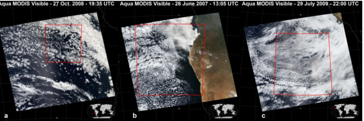
Fig. 4.Aqua MODIS visible quick-look imagery for the areas in Figs. 7, 9, and 10 from left to right (http://modis-atmos.gsfc.nasa.gov/ IMAGES/index myd021km.html).(a)is for the southeast Pacific on 27 October 2008 at≈19:35 UTC.(b)is for the southeast Atlantic on 26 June 2007 at≈13:05 UTC.(c)is for the northeast Pacific on 29 July 2009 at≈22:00 UTC. The red boxes denote the areas of interest for the scenes in question.
Table 1.Summary of hit, miss, and false alarm rates for 12 scenes in Fig. 3.
Minimum (%) Average (%) Maximum (%)
Hit rate 43.9 76.8 98.4
Miss rate 0.0 2.2 9.0
False alarm rate 0.9 21.0 54.0
3.2 Comparison among satellite algorithms
We compare our binary heavy drizzle detection algorithm to the well-established MODIS LWP and AMSR-E LWP prod-ucts in daylight scenes containing marine stratocumulus from the southeast Pacific, the southeast Atlantic, and the north-east Pacific (Figs. 4–7, and Table 2). The comparison uses both the quantitative AMSR-E LWP and MODIS LWP data as well as two derived binary products based on AMSR-E LWP and MODIS LWP values≥200 g m−2 (Figs. 5–7). We recognize that heterogeneous beam filling means that a 200 g m−2 threshold applied to the 1 km×1 km resolu-tion MODIS LWP product is not equivalent to a 200 g m−2 threshold applied to the 14 km×8 km resolution AMSR-E LWP product. Ideally, we should use a lower threshold for the coarser-resolution AMSR-E LWP. Such a calcula-tion would require quantitative MODIS LWP data within ar-eas with low cloud fraction (regions of open cells) where the MODIS algorithm is known to have large uncertainties (Seethala and Horv´ath, 2010). For our purposes, application of a 200 g m−2threshold to AMSR-E LWP will provide a ro-bustunderestimateof the heavily drizzling area compared to MODIS LWP. Similarly, our 89-GHz brightness temperature product willunderestimatetotal drizzle area compared to the higher spatial resolution MODIS LWP assuming that indi-vidual drizzle elements have an area equal to or larger than the 6 km×4 km pixel size of the 89-GHz channel.
Microwave and optical methods of estimating LWP gener-ally agree with each other and perform well for marine stra-tocumulus regions (Lin and Rossow, 1994; Borg and Ben-nartz, 2007). More specifically, Seethala and Horv´ath (2010) state that AMSR-E and MODIS estimations of LWP agree best for stratocumulus regions and for other overcast regions when cloud fraction values are greater than 0.9. Within high cloud fraction conditions of marine stratocumulus regions, they found correlations up to 0.95 between AMSR-E LWP and MODIS LWP. For lower cloud fraction values, AMSR-E overestimates domain-mean LWP compared to MODIS. The changes in relative performance as a function of cloud frac-tion are likely a result of 3-D cloud effects, differences in the spatial resolution of the two products, and beam filling uncertainties.
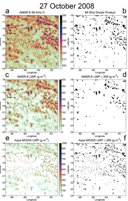
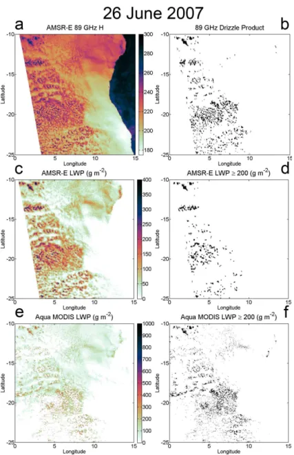
Co-registered 89-GHz brightness temperature data, our 89-GHz–based binary detection product, AMSR-E LWP, and MODIS LWP data are shown in Figs. 5–7. Figure 5 shows an area over the southeast Pacific on 27 October 2008. Satel-lite data from a scene with drizzle over the southeast Atlantic off the coast of Africa for 26 June 2007 are shown in Fig. 6. There are some high, mostly transparent, cirrus clouds in this scene with cloud-top temperatures<273 K in a southwest to northeast strip at approximately 23◦
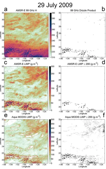
S latitude. The marine stratocumulus clouds common to this region have never been the subject of a major field observation campaign. Satellite data for an area over the northeast Pacific for 29 July 2009 that contains drizzle are shown in Fig. 7. This scene is a complex example with a strong SST gradient. In the south-ern half of this scene, 89-GHz brightness temperatures are higher compared to the other examples in part because of higher SST and IWV values.
Fig. 5.Drizzle information for the southeast Pacific on 27 October 2008 at≈19:35 UTC.(a)is AMSR-E horizontally polarized 89-GHz brightness temperature from the L2A brightness temperature product.(c)is AMSR-E LWP from the L2 Ocean product.(e)is the Aqua MODIS daytime mean cloud water path from the MYD06 L2 product.(b)is the 89-GHz–based binary heavy drizzle classification field where black indicates drizzle.(d) is a binary field where black indicates AMSR-E LWP≥200 g m−2.(f)is a binary field where black indicates MODIS LWP≥200 g m−2.
smaller drizzle cells. The wider range of drizzle cell sizes de-tected by the 89-GHz–based method aids in determining the mesoscale spatial distribution of the drizzle. This mesoscale spatial structure of heavy drizzle is an important component in understanding the underlying physical processes (Com-stock et al., 2007). Recall from Sect. 1, thatthe primary ad-vantage of our algorithm is that it provides higher spatial res-olution information than AMSR-E LWP at night, when driz-zle is more intense and frequent, and when the MODIS LWP product is not available.
Fig. 6.Drizzle information for the southeast Atlantic on 26 June 2007 at≈13:05 UTC.(a)is AMSR-E horizontally polarized 89-GHz brightness temperature from the L2A brightness temperature product.(c)is AMSR-E LWP from the L2 Ocean product.(e)is the Aqua MODIS daytime mean cloud water path from the MYD06 L2 product.(b)is the 89-GHz–based binary heavy drizzle classification field where black indicates drizzle.(d) is a binary field where black indicates AMSR-E LWP≥200 g m−2.(f)is a binary field where black indicates MODIS LWP≥200 g m−2.
in the MODIS LWP data. Beam filling causes our algorithm to overestimate the size of the largest contiguous cells. This shifting of the size distribution has to be taken into account when examining results from our algorithm.
Table 2 summarizes the drizzle area statistics for the dif-ferent products in each scene. As expected, our binary heavy drizzle detection product identifies more drizzle area (≈50 % more) than the 200 g m−2 threshold applied to AMSR-E LWP. The 200 g m−2 threshold applied to MODIS LWP yields the largest drizzle areas with the exception of the southeast Atlantic scene where the 89-GHz–based binary
Fig. 7.Drizzle information for the northeast Pacific on 29 July 2009 at≈22:00 UTC.(a)is AMSR-E horizontally polarized 89-GHz bright-ness temperature from the L2A brightbright-ness temperature product.(c)is AMSR-E LWP from the L2 Ocean product.(e)is the Aqua MODIS daytime mean cloud water path from the MYD06 L2 product.(b) is the 89-GHz–based binary heavy drizzle classification field where black indicates drizzle.(d)is a binary field where black indicates AMSR-E LWP≥200 g m−2.(f)is a binary field where black indicates MODIS LWP≥200 g m−2.
4 Conclusions
Drizzle plays a key role in the evolution of marine stra-tocumulus and the transitions between closed- and open-cell states. The binary heavy drizzle classification product based on AMSR-E data described in this paper represents a new approach that provides additional information on the frequency of occurrence and spatial characteristics of driz-zle. Current satellite methods are either lacking in resolu-tion (AMSR-E LWP), night coverage (MODIS LWP), or the broad areal coverage (CloudSat) necessary to observe
the horizontal mesoscale structure of drizzling marine stra-tocumulus. Use of high-frequency passive microwave obser-vations to detect drizzle in marine stratocumulus environ-ments enables consistent observations at resolutions suffi-cient for resolving individual heavily drizzling cells and their mesoscale structure.
Table 2.Summary of total drizzle areas for products for scenes from Sect. 3.
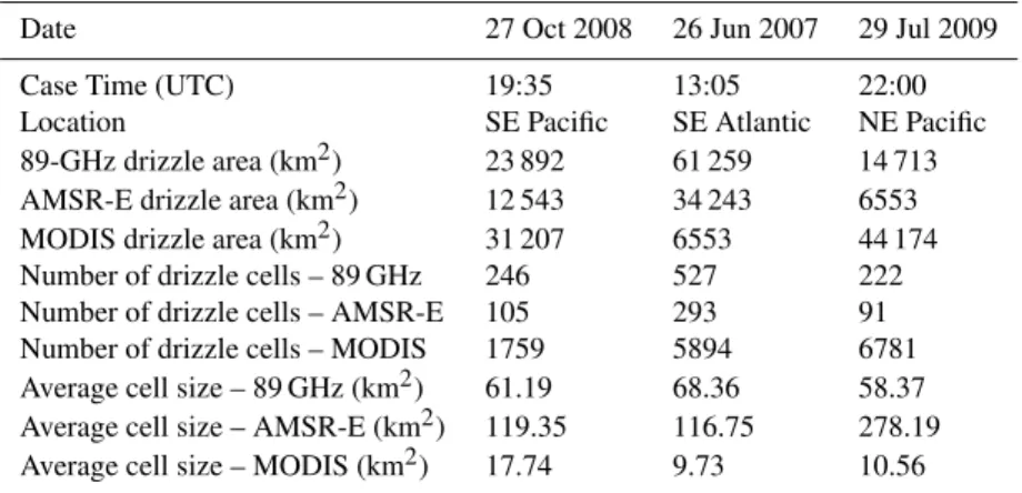
Date 27 Oct 2008 26 Jun 2007 29 Jul 2009
Case Time (UTC) 19:35 13:05 22:00
Location SE Pacific SE Atlantic NE Pacific
89-GHz drizzle area (km2) 23 892 61 259 14 713 AMSR-E drizzle area (km2) 12 543 34 243 6553 MODIS drizzle area (km2) 31 207 6553 44 174 Number of drizzle cells – 89 GHz 246 527 222 Number of drizzle cells – AMSR-E 105 293 91 Number of drizzle cells – MODIS 1759 5894 6781 Average cell size – 89 GHz (km2) 61.19 68.36 58.37 Average cell size – AMSR-E (km2) 119.35 116.75 278.19 Average cell size – MODIS (km2) 17.74 9.73 10.56
Count
89 GHz Drizzle Product
0 200 400 600 800 1000
100
101
102
103
Count
AMSR−E LWP ≥ 200 g m−2
0 200 400 600 800 1000
100
101
102
103
Area (km2)
Count
MODIS LWP ≥ 200 g m−2
0 200 400 600 800 1000
100
101
102
103
Total Area: 23892 km2
Total Area: 12543 km2
Total Area: 31207 km2
Fig. 8.Histograms comparing drizzle area calculated from the 89-GHz–based binary heavy drizzle classification product, AMSR-E LWP, and MODIS LWP for the time and region from Fig. 5. The upper panel is the area histogram for contiguous drizzle pock-ets detected using 89-GHz brightness temperature data. The middle panel is the area histogram for contiguous drizzle pockets defined as contiguous areas with AMSR-E LWP≥200 g m−2. The lower panel is the area histogram for contiguous drizzle pockets, defined as contiguous areas with MODIS LWP≥200 g m−2. The total area identified as drizzle is given for each product. Contiguous areas are identified based on 4-connectivity.
background brightness temperature threshold to which these local maxima can be compared. Once drizzle is identi-fied, standard connected-component algorithms are used to identify discrete drizzle cells and calculate various spatial statistics.
Even without an accompanying quantitative estimate of drizzle LWP, the satellite-based binary identification of heavy drizzle cells within marine stratocumulus regions will permit analysis of seasonal and regional drizzle cell occur-rence and the interrelation between drizzle and changes in cloud fraction. Several characteristics of contiguous drizzle cell features can be documented: the number of drizzle cells per unit area, their sizes and shape, and the distances between cells. In ongoing work, we are using these properties as com-parison metrics among the different marine stratocumulus re-gions. The information on marine stratocumulus drizzle from the 89-GHz–based drizzle detection algorithm will also pro-vide an avenue for evaluation of numerical model parameter-izations. Future work is planned for extending this methodol-ogy to the TRMM microwave radiometer 85.5 GHz channel in order to provide data over the full diurnal cycle.
Acknowledgements. The authors would like to thank Robert Pincus
and Casey Burleyson for their helpful reviews on draft versions of this manuscript.
This research was supported by NASA Earth and Space Sci-ence Fellowship NNX07AN71H, NOAA grant GC08-252b, and NASA EOS grant NNX11AE98G.
References
Ashcroft, P. and Wentz, F.: AMSR-E/Aqua L2A Global Swath Spatially-Resampled Brightness Temperatures V002, Various dates, http://www.nsidc.org/data/amsre, National Snow and Ice Data Center, Boulder, Colorado, USA, 2006.
Borg, L. A. and Bennartz, R.: Vertical structure of stratiform marine boundary layer clouds and its impact on cloud albedo, Geophys. Res. Lett., 34, L05807, doi:10.1029/2006GL028713, 2007. Bretherton, C. S., Uttal, T., Fairall, C. W., Yuter, S., Weller, R.,
Baumgardner, D., Comstock, K., and Wood, R.: The EPIC 2001 stratocumulus study, B. Am. Meteorol. Soc., 85, 967–977, 2004. Comstock, K. K., Wood, R., Yuter, S. E., and Bretherton, C. S.: Reflectivity and rain rate in and below drizzling stratocumulus, Q. J. Roy. Meteorol. Soc., 130, 2891–2918, 2004.
Comstock, K. K., Bretherton, C. S., and Yuter, S. E.: Mesoscale variability and drizzle in southeast Pacific stratocumulus, J. At-mos. Sci., 62, 3792–3807, 2005.
Comstock, K., Yuter, S. E., Wood, R., and Bretherton, C. S.: The three-dimensional structure and kinematics of drizzling stratocu-mulus, Mon. Weather Rev., 135, 3767–3784, 2007.
Crewell, S. and Lˇohnert, U.: Accuracy of cloud liquid water path from ground-based microwave radiometry 2. Sensor accuracy and synergy, Radio Sci., 38, 8042, doi:10.1029/2002RS002634, 2003.
de Szoeke, S. P., Yuter, S. E., Zuidema, P., Fairall, C. W., and Brewer, W. A.: Ship-based observation of drizzling stratocumu-lus clouds from EPIC to VOCALS, CLIVAR Exchanges, 15, 11– 13, 2010.
Greenwald, T. J.: A 2 year comparison of AMSR-E and MODIS cloud liquid water path observations, Geophys. Res. Lett., 36, L20805, doi:10.1029/2009GL040394, 2009.
Greenwald, T. J., L’Ecuyer, T. S., and Christopher, S. A.: Evaluating specific error characteristics of microwave derived cloud liquid water products, Geophys. Res. Lett., 34, L22807, doi:10.1029/2007GL031180, 2007.
Haralick, R. M. and Shapiro, L. G.: Computer and Robot Vision, Addison-Wesley Longman Publishing Co., Inc, 1992.
Hartmann, D. L., Ockert-Bell, M. E., and Michelsen, M. L.: The effect of cloud type on Earth’s energy balance: global analysis, J. Climate, 5, 1281–1304, 1992.
Haynes, J. and Stephens, G. L.: Tropical oceanic cloudiness and the incidence of precipitation: early results from CloudSat, Geophys. Res. Lett., 34, L09811, doi:10.1029/2007GL029335, 2007. Horv´ath, ´A. and Gentemann, C.: Cloud-fraction-dependent bias
in satellite liquid water path retrievals of shallow, non-precipitating marine clouds, Geophys. Res. Lett., 34, L22806, doi:10.1029/2007GL030625, 2007.
Jones, A. S. and Vonder Haar, T. H.: Retrieval of microwave sur-face emittance over land using coincident microwave and in-frared satellite measurements, J. Geophys. Res., 102, 13609– 13626, doi:10.1029/97JD00797, 1997.
Kawanishi, T., Sezai, T., Ito, Y., Imaoka, K., Takeshima, T., Ishido, Y., Shibata, A., Miura, M., Inahata, H., and Spencer, R. W.: The Advanced Microwave Scanning Radiometer for the Earth Ob-serving System (AMSR-E), NASDA’s contribution to the EOS for global energy and water cycle studies, IEEE T. Geosci. Re-mote, 41, 184–194, 2003.
Kida, S., Shige, S., Kubota, T., Aonashi, K., and Okamoto, K.: Im-provement of rain/no-rain classification methods for microwave radiometer observations over the Ocean Using a 37 GHz Emis-sion Signature, J. Meteorol. Soc. Jpn., 87A, 165–181, 2009. Kidder, S. Q. and Vonder Haar, T. H.: Satellite Meteorology: An
Introduction, Academic Press, 466 pp., doi:10.1016/B978-0-08-057200-0.50007-9, 1995.
King, M. D., Menzel, W. P., Kaufman, Y. J., Tanre, D., Gao, B.-C., Platnick, S., Ackerman, S. A., Remer, L. A., Pincus, R., and Hubanks, P. A.: Cloud and aerosol properties, pre-cipitable water, and profiles of temperature and water va-por from MODIS, IEEE T. Geosci. Remote, 41, 442–458, doi:10.1109/TGRS.2002.808226, 2003.
Kubar, T. L., Hartmann, D. L., and Wood, R.: Understanding the importance of microphysics and macrophysics for warm rain in marine low clouds, Part I: satellite observations, J. Atmos. Sci., 66, 2953–2972, doi:10.1175/2009JAS3071.1, 2009.
Kummerow, C., Barnes, W., Kozu, T., Shiue, J., and Simpson, J.: The Tropical Rainfall Measuring Mission (TRMM) sensor pack-age, J. Atmos. Ocean. Tech., 15, 809–817, 1998.
Lafont, D. and Guillemet, B.: Subpixel fractional cloud cover and inhomogeneity effects on microwave beam-filling error, Atmos. Res., 72, 149–168, doi:10.1016/j.atmosres.2004.03.013, 2004. Leon, D. C., Wang, Z., and Liu, D.: Climatology of drizzle in
marine boundary layer clouds based on 1 year of data from CloudSat and Cloud-Aerosol Lidar and Infrared Pathfinder Satel-lite Observations (CALIPSO), J. Geophys. Res., 113, D00A14, doi:10.1029/2008JD009835, 2008.
Lin, B. and Rossow, W. B.: Observations of cloud liquid water path over oceans: optical and microwave remote sensing methods, J. Geophys. Res., 99, 20907–20927, doi:10.1029/94JD01831, 1994.
O’Connor, E. J., Hogan, R. J., and Illingworth, A. J.: Retriev-ing Stratocumulus Drizzle Parameters UsRetriev-ing Doppler Radar and Lidar, J. Appl. Meteorol., 44, 14–27 doi:10.1175/JAM-2181.1, 2005.
Petty, G. W.: Physical retrievals of over-ocean rain rate from multi-channel microwave imagery, Part II: algorithm implementation, Meteorol. Atmos. Phys., 54, 101–122, 1994.
Petty, G. W. and Katsaros, K. B.: Precipitation observed over the South China Sea by the Nimbus-7 Scanning Multichannel Mi-crowave Imager during WMONEX, J. Appl. Meteorol., 29, 273– 287, 1990.
Petty, G. W. and Katsaros, K. B.: Nimbus 7 SMMR precipitation observations calibrated against surface radar during TAMEX, J. Appl. Meteorol., 31, 489–505, 1992.
Rosenfeld, A. and Pfaltz, J. L.: Sequential operations in digital pic-ture processing, J. Assoc. Comput. Mach., 13, 471–494, 1966. Savic-Jovic, V. and Stevens, B.: The structure and mesoscale
orga-nization of precipitating stratocumulus, J. Atmos. Sci., 65, 1587– 1605, 2008.
Seethala, C. and Horv´ath, ´A.: Global assessment of AMSR-E and MODIS cloud liquid water path retrievals in warm oceanic clouds, J. Geophys. Res., 115, D13202, doi:10.1029/2009JD012662, 2010.
2006.
Stephens, G. L., Vane, D. G., Boain, R. J., Mace, G. G., Sassen, K., Wang, K., Illingworth, A. J., O’Connor, E. J., Rossow, W. B., Durden, S. L., Miller, S. D., Austin, R. T., Benedetti, A., Mitrescu, C., and the CloudSat Science Team: The CloudSat mis-sion and the A-TRAIN, B. Am. Meteorol. Soc., 83, 1771–1790, doi:10.1175/BAMS-83-12-1771, 2002.
Stephens, G. L., Vane, D. G., Taneli, S., Im, E., Durden, S., Rokey, M., Reinke, D., Partain, P., Mace, G. G., Austin, R., L’Ecuyer, T., Haynes, J., Lebsock, M., Sukuki, K., Waliser, D., Wu, D., Key, J., Gettelman, A., Wang, Z., and Marchand, R.: Cloudsat mission: performance and early science after the first year of operation, J. Geophys. Res., 113, D00A18, doi:10.1029/2008JD009982, 2008.
Stevens, B., Vali, G., Comstock, K., Wood, R., van Zanten, M. C., Austin, P. H., Bretherton, C. S., and Lenschow, D. H.: Pockets of open cells (POCs) and drizzle in marine stratocumulus, B. Am. Meteorol. Soc., 86, 51–57, 2005.
van Zanten, M. C. and Stevens, B.: On the observed structure of heavily precipitating marine stratocumulus, J. Atmos. Sci., 62, 4327–4342, 2005.
Wang, H. and Feingold, G.: Modeling mesoscale cellular structures and drizzle in marine stratocumulus, Part I: impact of drizzle on the formation and evolution of open cells, J. Atmos. Sci., 66, 3237–3256, 2009.
Wentz, F. J. and Meissner, T.: AMSR Ocean Algorithm, Version 2, vol. 121599A-1, Remote Sensing Systems, Santa Rosa, CA, 2000.
Wentz, F. and Meissner, T.: AMSR-E/Aqua L2B Global Swath Ocean Products Derived from Wentz Algorithm V002, various dates, http://www.nsidc.org/data/amsre, National Snow and Ice Data Center, Boulder, Colorado, USA, 2004.
Westwater, E. R., Han, Y., Shupe, M., and Matrosov, S. Y.: Analysis of integrated cloud liquid and precipitable water vapor retrieval from microwave radiometers during the surface heat budget of the Arctic Ocean project, J. Geophys. Res., 106, 32019–32030, 2001.
Wood, R., Bretherton, C. S., Leon, D., Clarke, A. D., Zuidema, P., Allen, G., and Coe, H.: An aircraft case study of the spa-tial transition from closed to open mesoscale cellular convection over the Southeast Pacific, Atmos. Chem. Phys., 11, 2341–2370, doi:10.5194/acp-11-2341-2011, 2011a.
Wood, R., Mechoso, C. R., Bretherton, C. S., Weller, R. A., Huebert, B., Straneo, F., Albrecht, B. A., Coe, H., Allen, G., Vaughan, G., Daum, P., Fairall, C., Chand, D., Gallardo Klenner, L., Garreaud, R., Grados, C., Covert, D. S., Bates, T. S., Krejci, R., Russell, L. M., de Szoeke, S., Brewer, A., Yuter, S. E., Springston, S. R., Chaigneau, A., Toniazzo, T., Minnis, P., Palikonda, R., Abel, S. J., Brown, W. O. J., Williams, S., Fochesatto, J., Brioude, J., and Bower, K. N.: The VAMOS Ocean-Cloud-Atmosphere-Land Study Regional Experiment (VOCALS-REx): goals, plat-forms, and field operations, Atmos. Chem. Phys., 11, 627–654, doi:10.5194/acp-11-627-2011, 2011, 2011b.