HESSD
6, 2733–2750, 2009Assessment of soil moisture from climate models
G. Schumann et al.
Title Page
Abstract Introduction
Conclusions References
Tables Figures
◭ ◮
◭ ◮
Back Close
Full Screen / Esc
Printer-friendly Version
Interactive Discussion Hydrol. Earth Syst. Sci. Discuss., 6, 2733–2750, 2009
www.hydrol-earth-syst-sci-discuss.net/6/2733/2009/ © Author(s) 2009. This work is distributed under the Creative Commons Attribution 3.0 License.
Hydrology and Earth System Sciences Discussions
Papers published inHydrology and Earth System Sciences Discussionsare under open-access review for the journalHydrology and Earth System Sciences
Assessment of soil moisture fields from
imperfect climate models with uncertain
satellite observations
G. Schumann1, D. J. Lunt1,2, P. J. Valdes1, R. A. M. de Jeu3, K. Scipal4, and
P. D. Bates1
1
School of Geographical Sciences, University of Bristol, University Road, Bristol, BS8 1SS, UK
2
Geological Sciences Division, British Antarctic Survey, Cambridge, CB3 0ET, UK
3
Department of Hydrology and Geo-Environmental Sciences, Vrije Universiteit Amsterdam, Amsterdam, The Netherlands
4
Institute of Photogrammetry and Remote Sensing, Vienna University of Technology, 1040, Vienna, Austria
Received: 16 March 2009 – Accepted: 19 March 2009 – Published: 27 March 2009 Correspondence to: G. Schumann ([email protected])
HESSD
6, 2733–2750, 2009Assessment of soil moisture from climate models
G. Schumann et al.
Title Page
Abstract Introduction
Conclusions References
Tables Figures
◭ ◮
◭ ◮
Back Close
Full Screen / Esc
Printer-friendly Version
Interactive Discussion
Abstract
We demonstrate that global satellite products can be used to evaluate climate model soil moisture predictions but conclusions should be drawn with care. The quality of a limited area climate model (LAM) was compared to a general circulation model (GCM) using soil moisture data from two different Earth observing satellites within a model 5
validation scheme that copes with the presence of uncertain data. Results showed that in the face of imperfect models and data, it is difficult to investigate the quality of current land surface schemes in simulating hydrology accurately. Nevertheless, a LAM provides, in general, a better representation of spatial patterns and dynamics of soil moisture. However, in months when data uncertainty is higher, particularly in colder 10
months and in periods when vegetation cover and soil moisture are out of phase (e.g. August in the case of Western Europe), it is not possible to draw firm conclusions about model acceptability. Our work indicates that a higher resolution LAM has more benefits to soil moisture prediction than are due to the resolution alone and can be attributed to an overall intensification of the hydrological cycle relative to the GCM.
15
1 Introduction
The land surface is a key component in climate models (CMs) and controls the par-titioning of available energy at the surface between sensible and latent heat (ground flux), and of available water between evaporation and runoff(Pitman, 2003). The con-trol of soil moisture on the partitioning of the heat fluxes is a key mechanism because 20
the dynamics of soil moisture content thereby influence the variability in both weather and climate (Entekhabi et al., 1996). Simulations from climate models are increasingly being used in other applications. In particular for hydrological models being applied to assess future or past changes in hydrological behaviour, land surface schemes (LSSs) in CMs need to be evaluated against some sort of data. Given that these models are 25
HESSD
6, 2733–2750, 2009Assessment of soil moisture from climate models
G. Schumann et al.
Title Page
Abstract Introduction
Conclusions References
Tables Figures
◭ ◮
◭ ◮
Back Close
Full Screen / Esc
Printer-friendly Version
Interactive Discussion surface variables is difficult to perform. It is argued by Cornwell Cornwell and Harvey
(2007) that while the quality of CM-LSSs seems to be improving (although there still are large inconsistencies in predictions), without high-quality long-term observations there remains significant uncertainty in the evolution of CM predictions of soil moisture change.
5
However, satellites acquire data over very similar scales to climate models, and thus present an invaluable source of validation data. Many different techniques exist to de-rive soil moisture from passive as well as active microwave sensors. These range from less complex change detection algorithms (Wagner et al., 1999) to more sophisticated integration of land parameter retrieval models (Owe et al., 2001). It is important to 10
note the many differences in definition of soil moisture that exist. LSSs are most con-cerned with heat and energy fluxes and soil moisture is treated and defined differently by different CM-LSSs (Cornwell and Harvey, 2007). Although efforts are being made to improve soil moisture retrieval from remote sensing, in some existing algorithms, soil moisture is represented as a wetness index whereby changes with depth or the effects 15
of heat and moisture fluxes are only partially represented.
We use the global soil moisture products from the Advanced Microwave Scanning Radiometer onboard the Earth Observation satellite (AMSR-E) and the scatterometer sensor on the European Remote Sensing satellite (ERS-2) to propose a scheme to assess the quality and value of soil moisture simulated by a limited area model (LAM), 20
HadRM (Jones et al., 1995), and a general circulation model (GCM), HadAM3 (Pope et al., 2000). By doing so, it is the aim to justify the development and use of a LAM. For instance, more reliable higher resolution limited area models could provide valu-able input data for large scale hydrological modeling under different climate change scenarios.
HESSD
6, 2733–2750, 2009Assessment of soil moisture from climate models
G. Schumann et al.
Title Page
Abstract Introduction
Conclusions References
Tables Figures
◭ ◮
◭ ◮
Back Close
Full Screen / Esc
Printer-friendly Version
Interactive Discussion
2 Data
2.1 Active scatterometer data
Global, coarse-resolution soil moisture data (25–50 km) are derived from backscat-ter measurements from active scatbackscat-teromebackscat-ters on-board ERS-1 and ERS-2 (1991 to present) and the three MetOp satellites (2006–2020). Surface soil moisture data are 5
derived using a change detection method for radar backscatter that relies upon the multi-incidence observation capabilities of the scatterometer to model the effects of vegetation phenology (Wagner et al., 1999). This technique retrieves topsoil moisture content (<5 cm) in a relative quantity ranging between 0 and 1 (respectively, 0–100%), scaled between zero soil moisture and saturation. The data can be obtained free of 10
charge at http://www.ipf.tuwien.ac.at/radar/.
2.2 Passive AMSR-E data
Parameters for soil moisture retrieval are derived from passive microwave remote sens-ing data ussens-ing the Land Parameter Retrieval Model (LPRM). The LPRM is based on a forward radiative transfer model to retrieve surface soil moisture and vegetation op-15
tical depth (VOD), i.e. vegetation wetness (Owe et al., 2001). A unique feature of this method is that it may be applied at any microwave frequency (<20 GHz), making it very suitable to exploit all the available passive microwave data from historic satellites (Owe et al., 2008). This dataset describes volumetric soil moisture (in m3m−3) of the first top centimeters (1–2 cm) with an average accuracy of 0.06 m3m−3for sparse to moderate 20
HESSD
6, 2733–2750, 2009Assessment of soil moisture from climate models
G. Schumann et al.
Title Page
Abstract Introduction
Conclusions References
Tables Figures
◭ ◮
◭ ◮
Back Close
Full Screen / Esc
Printer-friendly Version
Interactive Discussion
2.3 Soil moisture from climate models
Soil moisture is simulated within both CMs using MOSES (Meteorological Office Sur-face Exchange Scheme) from the UK Meteorological Office (UKMO) (Cox et al., 1999). MOSES is a land surface scheme that reproduces terrestrial processes according to a simplified surface flux partitioning scheme. For moisture flux, the surface hydrology 5
is defined in terms of the soil moisture vertical profile, snow lying on the ground and water on plant leaves or on the soil surface. The soil hydrology component of MOSES is based on a finite difference approximation to Richards’ equation (Cox et al., 1999) and moisture content is output for four vertical profiles (0.1, 0.25, 0.65 and 2.0 m), of which the top one (10 cm) is used for comparison in this study. Both CMs generate 10
atmospheric conditions that interact with MOSES to output soil moisture.
HadAM3, with a grid resolution of 2.5 degrees latitude by 3.75 degrees longitude, is an improved version of the former Hadley Centre atmospheric model HadAM2b (Strat-ton, 1999) and is based on the Unified Model (UM) system. The HadAM3 simulations assessed in this paper are identical to the modern control simulations of Jost et al. 15
(2005). The atmospheric model is initialized by observed climatological monthly mean sea surface temperatures (SSTs) (over 30 years), and so simulations do not corre-spond to any particular year. In other words, this study compares the seasonal cycle between data sets and not individual years.
HadRM is a limited area atmospheric model also belonging to the UM system, which 20
is driven at its lateral boundaries and at the sea surface by a time series of data archived from a previous integration of HadAM3. Locatable over any part of the globe, it is typically run for short periods (i.e.<20 years) at a horizontal grid resolution of 0.44 degrees, as opposed to global simulations of long periods of time, which generates high-resolution climate change information for particular regions, however, the relative 25
HESSD
6, 2733–2750, 2009Assessment of soil moisture from climate models
G. Schumann et al.
Title Page
Abstract Introduction
Conclusions References
Tables Figures
◭ ◮
◭ ◮
Back Close
Full Screen / Esc
Printer-friendly Version
Interactive Discussion
3 Methods
3.1 Data pre-processing
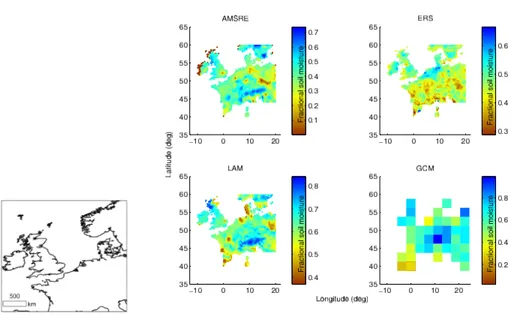
For data quality assessment, both remote sensing data sets were translated onto a common grid over the chosen study area of Western Europe (Fig. 1). The Delaunay Triangulation method (Guibas and Stolfi, 1985) was used to plot data onto a common 5
grid resolution of 0.5 degrees, as it does not assume any special arrangement of the data points used. Thereafter, soil moisture values were scaled between 0 and 1 (frac-tional soil moisture) in the spatial domain for sake of comparing different sources of soil moisture (Fig. 1).
Given that climate model outputs are available on a monthly basis for six years con-10
strained by climatological mean SSTs (with an additional eight years spin-up time) for both the LAM and GCM, averaging all daily remote sensing values over a month for 3–4 years from 2004 to 2006/2007 for each sensor separately was assumed sensible. Although AMSR-E data are available on a daily basis whilst ERS data are acquired every 3 days, it is assumed that this difference is assumed negligible for monthly aver-15
aging. It is worth noting that although remote sensing data from both sensors are also available for the entire year of 2003, this year was omitted because (a) the ERS sensor was switched offa number of times and (b) the strong abnormal heat wave over Eu-rope that summer had considerable effects on soil moisture conditions (Fischer et al., 2007), and as a result, both climate models (for normal atmospheric conditions) would 20
be inappropriately penalized during evaluation.
3.2 Defining an appropriate LSS assessment scheme
After data pre-processing, the agreement of monthly soil moisture values between the two remote sensing sensors was assessed using histogram distributions in the form of box plots (Fig. 2). This gave an appreciation of data consistency over a full year. A 25
HESSD
6, 2733–2750, 2009Assessment of soil moisture from climate models
G. Schumann et al.
Title Page
Abstract Introduction
Conclusions References
Tables Figures
◭ ◮
◭ ◮
Back Close
Full Screen / Esc
Printer-friendly Version
Interactive Discussion Europe of∼0.2 in fractional soil moisture for most months indicated a good agreement
(pixel by pixel) between the two products. Reciprocally, the degree of disagreement between the two products may be viewed as a measure of the uncertainty associated with the data. This information can be used in an evaluation scheme where both model and observation data are known to be in error. Such schemes have recently gained 5
popularity in hydrological studies (Beven, 2006) and is used here to assess both climate models.
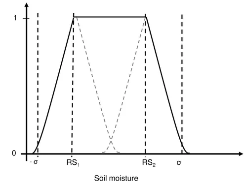
Given that soil moisture is highly variable in its nature, is poorly defined and re-produced differently by climate modeling as well as remote sensing, a fit-for-purpose model evaluation scheme, which copes with errors in both data and models as de-10
scribed above, needed to be defined. In the hydrology literature a number of different fuzzy rules-based membership functions have been used (e.g. Beven, 2006; Pappen-berger et al., 2007)). We implemented a trapazoidal non-linear function (Fig. 3) that defines an adequate number of degrees of freedom within a fuzzy membership defini-tion based on an interval of monthly mean remotely sensed soil moisture, the bounds 15
of which are defined by the two satellite observations (RS1andRS2respectively) from 2004 to 2006/2007. Outside either side of this interval a Gaussian function is defined byRS±σ. In the case of observations from two different sources, the degree of vari-ability (σ) is composed not only of a natural variability of the variable but also the level of disagreement between the sources themselves. The membership function that gives 20
the acceptability (ALSS) of the mean of monthly soil moisture outputs (LSS) from the LAM and GCM over Europe is defined in Eq. (1) below.
ALSS=
1 RS1≤LSS≤RS2
ae
−(LSS−RS1)
2c21
LSS< RS1 ae
−(LSS−RS2)
2c2
2 LSS> RS2
(1)
Where a equals 1, c1 equals RS1±σ and c2 equals RS2±σ whereσ denotes the
HESSD
6, 2733–2750, 2009Assessment of soil moisture from climate models
G. Schumann et al.
Title Page
Abstract Introduction
Conclusions References
Tables Figures
◭ ◮
◭ ◮
Back Close
Full Screen / Esc
Printer-friendly Version
Interactive Discussion peak, RS1 and RS2 denote the position of the center of the peak, and c1 and c2
control the width of the function. By adopting a conditional membership function, it is ensured that the LSS is given a maximum acceptability of 1 if it falls inside an interval defined by the mean soil moisture of the two satellite instruments over the 3–4 years and decreasing acceptabilities following a Gaussian distribution on either side of the 5
interval±σ.
4 Results and discussion
4.1 Remote sensing soil moisture
Figure 1 shows that there is a strong spatial consistency between the AMSR-E derived soil moisture and that simulated by both climate models, but in places different spatial 10
patterns are observed in the ERS scatterometer soil moisture. This is most probably because the AMSR-E algorithm and MOSES are physically based whereas the scat-terometer data are obtained using a multi-incidence change detection algorithm which may lead to greater spatial inconsistencies.
A more thorough analysis of the data revealed that there is in general a good agree-15
ment between the monthly mean soil moisture values of the two sensors. Over Europe, absolute differences are for most months less than 0.15 in fractional soil moisture. This is reflected in Fig. 4b which illustrates that observed data variability is generally of σ<0.15, except for colder months, particularly NDJ. It is believed that alongside the nat-ural variability of soil moisture, differences during colder months are primarily related 20
to difficulties in retrieving soil moisture at lower temperatures and over snow-covered areas, especially for single or extreme events. Disagreement during warmer months may result (i) from differences in retrieval algorithms and also to a certain degree in soil depth (1–2 cm for AMSR-E,<5 cm for ERS and 10 cm for MOSES) especially in summertime, (ii) when vegetation and soil moisture are “out of phase” (for active mi-25
HESSD
6, 2733–2750, 2009Assessment of soil moisture from climate models
G. Schumann et al.
Title Page
Abstract Introduction
Conclusions References
Tables Figures
◭ ◮
◭ ◮
Back Close
Full Screen / Esc
Printer-friendly Version
Interactive Discussion the AMSR-E), resulting in large uncertainties in retrieved soil moisture (de Jeu et al.,
2008). Also, at higher altitudes, large topographic variations as well as high vegetation add considerable uncertainties to the retrieval of soil moisture.
4.2 LSS acceptability
The analysis of the remote sensing soil moisture products confirms that both the de-5
gree of natural variability and the level of disagreement can be used to set limits of acceptability inside which the LAM and GCM need to fall to be acceptable. Figure 4a illustrates the acceptability of the LAM HadRM for each season alongside remote sens-ing data variability (Fig. 4b). In particular months (e.g. August in the case of West-ern Europe), with larger data intervals, apparent model performances increase. With 10
higher degrees of freedom to fit the data, higher levels of model acceptability are to be expected, given the nature of the proposed evaluation scheme. In months of higher natural data variability, there is at the same time more uncertainty in the data retrieval because of the factors outlined earlier.
To assess the percentage improvement that is to be gained with the HadRM over 15
Europe as opposed to the global HadAM3, the acceptability of the latter was computed and compared to the LAM translated onto the GCM grid. Equation (2) below gives the percentage improvement,ILAM, that can be achieved with a high resolution CM.
ILAM= P
LAM−PGCM
PGCM
×100 (2)
In HadRM, processes are better discretized due to the higher resolution, which re-20
sults in a more intense reprensentation of the hydrological cycle (Jones et al., 1995). Therefore outputs of highly spatially varying parameters are more heterogeneous, which can lead to a better fit with spatially and temporally varying observations. Fig-ure 5 showsILAMfor the four seasons. For months in which the two satellites disagree most (NDJF and also August), the gain in acceptability is less obvious and conclu-25
HESSD
6, 2733–2750, 2009Assessment of soil moisture from climate models
G. Schumann et al.
Title Page
Abstract Introduction
Conclusions References
Tables Figures
◭ ◮
◭ ◮
Back Close
Full Screen / Esc
Printer-friendly Version
Interactive Discussion give more similar values (MAMJJ) despite often more complex vegetation-soil
mois-ture relations (e.g. March and April), the improvement is striking and exceeds in some occasions 100%. These findings justify the development and use of a LAM.
One possibility to further improve soil moisture simulations in LSSs is laid out by Gedney et al. (2000) who found that differences among CM predictions of changes 5
in surface hydrology are particularly sensitive to how the runoffis parameterized over the active soil moisture range. Variations in the runoffat the critical soil moisture point account for much of the spread in predictions. Reducing the uncertainties in these pre-dictions will require improved treatment of runoffappropriate for the spatial resolution, rather than further sophistication in the treatment of evapotranspiration.
10
5 Conclusions
In a review of LSSs, Pitman (Pitman, 2003) points out that significant problems remain to be addressed, including difficulties in parameterizing hydrology and sub-grid-scale heterogeneity. Continued development of land surface models requires more multi-disciplinary efforts by scientists with a wide range of skills. In this context, we have 15
presented a possible evaluation scheme for CM-LSSs in the face of imperfect models and uncertain observations. The scheme reflects limitations of both current CM-LSSs and available remote sensing data.
Our work indicates that the use of a higher resolution LAM has more benefits to soil moisture prediction than are due to the resolution alone and can be attributed to 20
improved representation of precipitation and thus the hydrological cycle at an enhanced horizontal resolution (Jones et al., 1995).
We believe that higher resolution CMs need to be evaluated with observations that space-borne remote sensing could potentially provide. However, our results indicate that for some months model differences are around the same order of magnitude as 25
HESSD
6, 2733–2750, 2009Assessment of soil moisture from climate models
G. Schumann et al.
Title Page
Abstract Introduction
Conclusions References
Tables Figures
◭ ◮
◭ ◮
Back Close
Full Screen / Esc
Printer-friendly Version
Interactive Discussion associated with the data, such as presented by de Jeu et al. (2008), is also expected to
reveal more. Noteworthy is also the progress researchers currently make with higher resolution soil moisture retrieval from Envisat ASAR observations (<1 km resolution, see e.g. Loew et al., 2006). This is still in an experimental stage, but may become routinely available in the very near future. Also, improved data products from new 5
satellite missions, such as the Soil Moisture and Ocean Salinity (SMOS) mission, may allow us to better assess models.
Acknowledgements
G. Schumann was funded by a Mobility of Researchers grant (AM2c) of the Luxem-bourg National Research Fund (FNR) through the Public Research Centre-Gabriel 10
Lippmann (CRP-GL) in Luxembourg. D. J. Lunt was funded by fellowships from both the British Antarctic Survey (BAS) and Research Councils UK (RCUK). The authors are extremely grateful to both the NASA-VUA team and the Microwave Remote Sensing Group at TU Vienna for providing the satellite data. Many thanks go to Patrick Matgen at the CRP-GL and Florian Pappenberger at ECMWF for their helpful comments and 15
suggestions.
References
Beven, K.: A manifesto for the equifinality thesis, J. Hydrol., 320, 18–36, 2006. 2739
Cornwell, A. R. and Harvey, L. D. D.: Soil moisture: a residual problem underlying AGCMs, Clim. Change, 84, 313–336, 2007. 2735
20
Cox, P. M., Betts, R. A., Bunton, C. B., Essery, R. L. H., Rowntree, P. R., and Smith, J.: The impact of new land surface physics on the GCM simulation of climate and climate sensitivity, Clim. Dynam., 15, 183–203, 1999. 2737
de Jeu, R. A. M., Wagner, W., Holmes, T. R. H., Dolman, A. J., van de Giesen, N. C., and Friesen, J.: Global soil moisture patterns observed by space borne microwave radiometers
HESSD
6, 2733–2750, 2009Assessment of soil moisture from climate models
G. Schumann et al.
Title Page
Abstract Introduction
Conclusions References
Tables Figures
◭ ◮
◭ ◮
Back Close
Full Screen / Esc
Printer-friendly Version
Interactive Discussion
and scatterometers, Surveys in Geophysics, 29, 399–420, doi:10.1007/s10712-008-9044-0, 2008. 2736, 2741, 2743
Entekhabi, D., Rodriguez-lturbe, I., and Castelli, F.: Mutual interaction of soil moisture state and atmospheric processes, J. Hydrol., 184, 3–17, 1996. 2734
Fischer, E. M., Seneviratne, S. I., Vidale, P. L., Luethi, D., and Schaer, C.: Soil
moisture-5
atmosphere interactions during the 2003 European summer heat wave, J. Clim., 20, 5081– 5099, 2007. 2738
Gedney, N., Cox, P. M., Douville, H., Polcher, J., and Valdes, P. J.: Characterizing GCM land surface schemes to understand their responses to climate change, J. Clim., 13, 3066–3079, 2000. 2742
10
Guibas, L. and Stolfi, J.: Primitives for the manipulation of general subdivisions and the com-putation of Voronoi diagrams, ACM Transactions on Graphics, 4, 74–123, 1985. 2738 Jones, R. G., Murphy, J. M., and Noguer, M.: Simulation of climate change over Europe using
a nested regional-climate model. I: Assessment of control climate, including sensitivity to location of lateral boundaries, Q. J. Roy. Meteor. Soc., 121, 1413–1449, 1995. 2735, 2737,
15
2741, 2742
Jost, A., Lunt, D., Kageyama, M., Abe-Ouchi, A., Peyron, O., Valdes, P. J., and Ramstein, G.: High-resolution simulations of the last glacial maximum climate over Europe: a solution to discrepancies with continental palaeoclimatic reconstructions?, Clim. Dynam., 24, 577–590, 2005. 2737
20
Loew, A., Ludwig, R., and Mauser, W.: Derivation of surface soil moisture from ENVISAT ASAR Wide Swath and Image Mode data in agricultural areas, IEEE T. Geosci. Remote Sens., 44, 889–899, 2006. 2743
Owe, M., de Jeu, R., and Walker, J.: A methodology for surface soil moisture and vegetation optical depth retrieval using the microwave polarization difference index, IEEE T. Geosci.
25
Remote Sens., 39, 1643–1654, 2001. 2735, 2736
Owe, M., de Jeu, R. A. M., and Holmes, T. R. H.: Multi-sensor historical climatology of satellite-derived global land surface moisture, J. Geophys. Res., 113, doi:1029/2007JF000769, 2008. 2736
Pappenberger, F., Frodsham, K., Beven, K., Romanowicz, R., and Matgen, P.: Fuzzy
30
HESSD
6, 2733–2750, 2009Assessment of soil moisture from climate models
G. Schumann et al.
Title Page
Abstract Introduction
Conclusions References
Tables Figures
◭ ◮
◭ ◮
Back Close
Full Screen / Esc
Printer-friendly Version
Interactive Discussion
Pitman, A. J.: Review: The evolution of, and revolution in, land surface schemes designed for climate models, Int. J. Climatol., 23, 479–510, 2003. 2734, 2742
Pope, V. D., Gallani, M. L., Rowntree, P. R., and Stratton, R. A.: The impact of new physical parameterizations in the Hadley Centre climate model: HadAM3, Clim. Dynam., 16, 123– 146, 2000. 2735
5
Stratton, R. A.: A high resolution AMIP integration using the Hadley Centre model HadAM2b, Clim. Dynam., 15, 9–28, 1999. 2737
HESSD
6, 2733–2750, 2009Assessment of soil moisture from climate models
G. Schumann et al.
Title Page
Abstract Introduction
Conclusions References
Tables Figures
◭ ◮
◭ ◮
Back Close
Full Screen / Esc
Printer-friendly Version
Interactive Discussion
HESSD
6, 2733–2750, 2009Assessment of soil moisture from climate models
G. Schumann et al.
Title Page
Abstract Introduction
Conclusions References
Tables Figures
◭ ◮
◭ ◮
Back Close
Full Screen / Esc
Printer-friendly Version
Interactive Discussion
Jan Feb Mar Apr May Jun Jul Aug Sep Oct Nov Dec 0
0.2 0.4 0.6 0.8 1
Fractional soil moisture
Median
Upper and lower quartiles
95th and 5th percentiles
HESSD
6, 2733–2750, 2009Assessment of soil moisture from climate models
G. Schumann et al.
Title Page
Abstract Introduction
Conclusions References
Tables Figures
◭ ◮
◭ ◮
Back Close
Full Screen / Esc
Printer-friendly Version
Interactive Discussion
Fig. 3. Evaluation scheme based on a non-linear trapazoidal fuzzy membership function.RS1
andRS2represent monthly soil moisture values from the two satellites, meaning thatRS1and
HESSD
6, 2733–2750, 2009Assessment of soil moisture from climate models
G. Schumann et al.
Title Page Abstract Introduction Conclusions References Tables Figures ◭ ◮ ◭ ◮ Back Close
Full Screen / Esc
Printer-friendly Version
Interactive Discussion
−10 0 10 20 35 40 45 50 55 60 65 DJF Longitude (deg) Latitude (deg) 0 0.2 0.4 0.6 0.8 1
−10 0 10 20 35 40 45 50 55 60 65 DJF 0.05 0.1 0.15 0.2 0.25 0.3
−10 0 10 20 35 40 45 50 55 60 65 MAM 0 0.2 0.4 0.6 0.8 1
−10 0 10 20 35 40 45 50 55 60 65 MAM 0.05 0.1 0.15 0.2 0.25 0.3
−10 0 10 20 35 40 45 50 55 60 65 JJA 0 0.2 0.4 0.6 0.8 1
−10 0 10 20 35 40 45 50 55 60 65 JJA 0.05 0.1 0.15 0.2 0.25 0.3
−10 0 10 20 35 40 45 50 55 60 65 SON 0 0.2 0.4 0.6 0.8 1
−10 0 10 20 35 40 45 50 55 60 65 SON 0.05 0.1 0.15 0.2 0.25 0.3 b a
HESSD
6, 2733–2750, 2009Assessment of soil moisture from climate models
G. Schumann et al.
Title Page Abstract Introduction Conclusions References Tables Figures ◭ ◮ ◭ ◮ Back Close
Full Screen / Esc
Printer-friendly Version
Interactive Discussion
−10 0 10 20
35 40 45 50 55 60 65 DJF −15.2% Longitude (deg) Latitude (deg) −100 −50 0 50 100
−10 0 10 20
35 40 45 50 55 60 65 MAM 1.3% −100 −50 0 50 100
−10 0 10 20
35 40 45 50 55 60 65
JJA > 100%
−100 −50 0 50 100
−10 0 10 20
35 40 45 50 55 60 65 SON 52.5% −100 −50 0 50 100
% improvement (scaled)
% improvement (scaled) % improvement (scaled)
% improvement (scaled)
Fig. 5. Percentage improvement of soil moisture simulation when using a LAM instead of a GCM, for each season. The LAM is plotted to the GCM grid, which implicitly reflects the enhancement in surface dynamics representation that is to be gained with a LAM. Positive values indicate that the LAM gives a higher acceptability than the GCM and negative values show a lower acceptability of the LAM. Percentage values at top of plots give average ILAM
![Fig. 2. Line plot showing the distribution of the remote sensing soil moisture interval [RS 1 , RS 2 ] for each month.](https://thumb-eu.123doks.com/thumbv2/123dok_br/16455975.197896/15.918.102.602.106.499/line-showing-distribution-remote-sensing-moisture-interval-month.webp)
![Fig. 4. (a) The plots show LAM acceptabilities for each meteorological season, where a maxi- maxi-mum of 1 is attributed to a simulation that falls within the interval [RS 1 , RS 2 ] while a Gaussian function is applied outside that interval ±σ on either s](https://thumb-eu.123doks.com/thumbv2/123dok_br/16455975.197896/17.918.190.528.44.494/acceptabilities-meteorological-attributed-simulation-interval-gaussian-function-interval.webp)

