Hydrol. Earth Syst. Sci., 17, 1067–1077, 2013 www.hydrol-earth-syst-sci.net/17/1067/2013/ doi:10.5194/hess-17-1067-2013
© Author(s) 2013. CC Attribution 3.0 License.
Geoscientiic
Geoscientiic
Hydrology and
Earth System
Sciences
Open Access
Suspended sediment concentration–discharge relationships
in the (sub-) humid Ethiopian highlands
C. D. Guzman1, S. A. Tilahun2, A. D. Zegeye1,3, and T. S. Steenhuis1,2
1Department of Biological and Environmental Engineering, Cornell University, Ithaca, NY, USA 2School of Civil and Water Resources Engineering, Bahir Dar University, Bahir Dar, Ethiopia 3Amhara Regional Agricultural Research Institute (ARARI), Bahir Dar, Ethiopia
Correspondence to:T. S. Steenhuis (tss1@cornell.edu)
Received: 29 May 2012 – Published in Hydrol. Earth Syst. Sci. Discuss.: 30 July 2012 Revised: 31 January 2013 – Accepted: 8 February 2013 – Published: 11 March 2013
Abstract.Loss of top soil and subsequent filling up of reser-voirs in much of the lands with variable relief in develop-ing countries degrades environmental resources necessary for subsistence. In the Ethiopia highlands, sediment mobi-lization from rain-fed agricultural fields is one of the lead-ing factors causlead-ing land degradation. Sediment ratlead-ing curves, produced from long-term sediment concentration and dis-charge data, attempt to predict suspended sediment concen-tration variations, which exhibit a distinct shift with the pro-gression of the rainy season. In this paper, we calculate sed-iment rating curves and examine this shift in concentration for three watersheds in which rain-fed agriculture is prac-ticed to differing extents. High sediment concentrations with low flows are found at the beginning of the rainy season of the semi-monsoonal climate, while high flows and low sed-iment concentrations occur at the end of the rainy season. Results show that a reasonably unique set of rating curves were obtained by separating biweekly data into early, mid, and late rainfall periods and by making adjustments for the ratio of plowed cropland. The shift from high to low con-centrations suggests that diminishing sediment supply and dilution from greater base flow during the end of the rain-fall period play important roles in characterizing changing sediment concentrations during the rainy season.
1 Introduction
Soil erosion in the Ethiopian highlands, a natural phe-nomenon due to erosive rainfall and steep and undulating topography, is enhanced under agricultural systems that
re-duce protective soil cover (Vanmaercke et al., 2010; Haile et al., 2006; Hurni et al., 2005). Erosion and sedimentation rates are highly variable in response to climate and human influences (Nyssen et al., 2004). It is widely reported that presently land degradation rates and erosion rates have been accelerating due to the increasing rural population (Grunder, 1988; Desta et al., 2000; Hurni et al., 2005). At the same time, a large number of soil and water conservation (SWC) practices have been installed attempting to reduce soil loss (Hurni, 1988; Nyssen et al., 2008; Herweg and Ludi, 1999). It is not clear what the effectiveness of these practices is be-yond the immediate locations of where they have been tested (Vanmaercke et al., 2010). It is imperative therefore, in order to prevent siltation of the reservoirs of the dams planned on the major rivers, that the relationship between soil loss, dis-charge, and sediment concentration in rivers is understood. This will require a better understanding of the erosion pro-cesses. One of the obstacles is that most of our knowledge on erosion is based on empirical evidence for temperate climates while the Ethiopian highlands have a monsoonal climate with a long dry period and either one or two rainy periods.
The hydrology in monsoonal climates is quite different from the hydrology in temperate climates. For example, runoff coefficients (i.e., the portion of rainfall that becomes runoff) increase during the rainy season (Liu et al., 2008), while mean sediment concentrations fall as the rainy sea-son progresses, in both the semi-arid and humid parts of the highlands of Ethiopia as well as in other countries with monsoonal climates (Vanmaercke et al., 2010; Mulugeta, 1988; Lootens and Lumbu, 1986; Sharma et al., 1984). This falling concentration is unique for these climates and is not
well understood. Reasons mentioned in the literature claim that sediment available for transport by runoff is decreasing (Nyssen et al., 2004; Vanmaercke et al., 2010; Lootens and Lumbu, 1986; Sharma et al., 1984), plant cover protection is increasing (Haile et al., 2006, Zegeye et al., 2010), and rill formation has ceased (Zegeye et al., 2010). In the Univer-sal Soil Loss Equation modified for Ethiopian conditions by Hurni (1985), the decrease in sediment concentration was in-corporated in the C (vegetation) factor of the plants (Zegeye et al., 2010; Eweg et al., 1998; Haile et al., 2006). Models de-veloped in temperate climates such as the Agricultural Non-Point Source (AGNPS) Pollution Model (Haregeweyn and Yohannes, 2003; Mohammed et al., 2004), the Soil and Wa-ter Assessment Tool (SWAT) (Setegn et al., 2008, 2011), and Water Erosion Prediction Project (WEPP; Zeleke, 2000) can only predict monthly trends well under Ethiopian conditions. To account for Ethiopian conditions, Easton et al. (2010) and White et al. (2010) modified SWAT and replaced infiltration excess runoff processes by saturation excess and switched erosion controls from upland to channel factors after mid-August. For the Blue Nile at the border of Ethiopia and Su-dan, decreasing sediment concentration throughout the sea-son seems to be indicative of what is occurring within indi-vidual contributing catchments to the main stem of the river network.
One way of trying to improve our prediction of erosion processes is through sediment rating curves based on em-pirical knowledge from a specific region (Asselman, 2000). For the Ethiopian highlands, sediment rating curves are com-plex since sediment delivery depends on discharge, the on-set of rainfall, land use and land cover, which vary between rainfall seasons (Awulachew, 2010). However, developing these rating curves from a long record of sediment con-centration and associated runoff rates is a viable alternative to models that require a large number of different types of data inputs. Our objective is to quantify sediment concentra-tion changes in the Ethiopia highlands by investigating the relationship between sediment concentration and discharge in three watersheds.
2 Study areas
The three study watersheds are located in high rainfall ar-eas in the Ethiopian highlands with elevation generally above 1500 m (Hurni et al., 2005) where agriculture is dominant (Table 1). TheAndit Tid,Anjeni, andMaybarwatersheds are considered medium sized catchments with areas of 477 ha, 113 ha, and 112 ha, respectively, and are located in repre-sentative humid and sub-humid agro-climatic zones within different parts of central Ethiopia (Fig. 1). The sites are a part of a network of 7 regional agricultural research sites that provide hydrological data for the diversity of Ethiopia’s agro-climatic zones (Grunder, 1988; Bosshart, 1997). Andit Tid is the highest in elevation, largest in area, and the least
Fig. 1.Map of SCRP research stations (ETHIO-GIS, 2004).
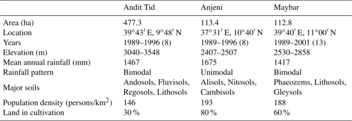
Table 1.Field site information (SCRP, 2000a, b, 2001; Yohannes, 1989; Leggesse, 2009; Hurni et al., 2005).
Andit Tid Anjeni Maybar
Area (ha) 477.3 113.4 112.8
Location 39◦43′E, 9◦48′N 37◦31′E, 10◦40′N 39◦40′E, 11◦00′N
Years 1989–1996 (8) 1989–1996 (8) 1989–2001 (13)
Elevation (m) 3040–3548 2407–2507 2530–2858
Mean annual rainfall (mm) 1467 1675 1417
Rainfall pattern Bimodal Unimodal Bimodal
Major soils Andosols, Fluvisols, Alisols, Nitosols, Phaeozems, Lithosols, Regosols, Lithosols Cambisols Gleysols
Population density (persons/km2) 146 193 188
Land in cultivation 30 % 80 % 60 %
3 Materials and methods
3.1 Field data
The data used was made available through the Amhara Re-gional Agricultural Research Institute (ARARI) and was originally collected by the Soil Conservation Research Pro-gramme as a joint program between the Ethiopian Min-istry of Agriculture and the University of Bern, Switzerland (Hurni, 1984). Seven research sites were established in the 1980s throughout Ethiopia and Eritrea to investigate soil ero-sion processes and the effects of soil and water conservation practices (Grunder, 1988). Specifically, this analysis makes use of the precipitation, evaporation, discharge, and sus-pended sediment concentration data. Discharge values were calculated from stage measurements at outlet weirs during storms and at daily intervals in the absence of storm rain-fall. Suspended sediment concentration was measured using the grab sample method with one-liter bottles. The samples were filtered, oven dried, and weighed to determine the mass of sediment captured per liter of discharge. During storm events, stage-discharge and suspended sediment concentra-tion measurements were taken at 10-min intervals and con-tinued until flow stabilized to pre-storm levels and the water became visibly clear (Bosshart, 1995).
3.2 Data processing and calculation of suspended
sediment transport
Instantaneous sediment concentration measurements were considered to be representative of the time frame,i, between which measurements were taken. Thus, concentration was considered constant during the duration of the 10-min or 30-min intervals, and sediment load, SLi (kg), during that time
interval was calculated by multiplying the watershed sus-pended sediment concentration,Cwi (kg m
−3), by the storm runoff volume,Rvi(m
3).
SLi=Cwi·Rvi (1)
The storm runoff volume was similarly calculated by assum-ing that the discharge flow rate was constant durassum-ing the time
interval, and thus runoff volume was obtained by multiply-ing the time duration,1ti (sec), by the discharge flow rate,
qi (m3sec−1).
Rvi=qi·1ti (2)
From these sediment load and storm runoff volume cal-culations, average sediment concentrations were calculated, where n equals the total number of measurements taken within a time frame.
Cw=SL
Rv
; SL=
n X i=1
SLi !
; Rv=
n X i=1
Rvi
!
(3)
In moving from sub-hourly instantaneous measurements to daily or biweekly time averages, only discharge flow surements that coincide with sediment concentration mea-surements were used. Thus, taking storm sediment concen-tration averages at the daily and biweekly timescales does not include flow that was measured outside of these occasions. This was done for two reasons. First, in a few instances, storms would occur and sediment concentration samples were not captured as frequently during the events as dis-charge measurements (Fig. S1). Secondly, in other instances, during part of the day sediment concentrations may have been captured, but during other parts measurements may not have been available (Fig. S2). Figures S3 and S4 show how this method affects concentration calculations. The intention of limiting discharge data to the storm flow only is to eval-uate specifically how storm discharge within the main rainy monsoon phase is affecting sediment concentration.
3.3 Sediment rating curves
To estimate sediment concentrations based on storm runoff volume per unit area over a specified period (Rd; mm day−1), sediment rating curves were developed using a power func-tion and constants were obtained using power-type regres-sion (Walling, 1977; Asselman, 2000).
Cw=a×Rbd (4)
Ciesiolka et al. (1995) estimated that a power of 0.4 in this equation is appropriate for the upper limit of sediment concentration (transport limit) using the kinematic flow ap-proximation and assumption of turbulent flow. This value will fluctuate by an erodibility factor, β, which is multi-plied by the exponent for the average sediment concentra-tion. The erodibility factor is usually at or below a value of 1 (β≤1). Under exceptionally erodible conditions, such as just after cultivation and under high rainfall detachment and re-detachment, this factor may increase above 1 and result in abexponent of slightly higher than 0.4 (Paningbatan et al., 1995; Sombatpanit et al., 1995). Asselman (2000) indicates that the physical interpretation for these coefficients has var-ied from author to author, some attributing thebcoefficient to be indicative of the erosive power of the stream, while oth-ers, such as Vanmaercke et al. (2010), view thebcoefficient as a measure of the extent to which new sediment sources become available.
Daily precipitation and evaporation values were summed, and average storm sediment concentration and storm dis-charge were calculated for daily, weekly, biweekly, and monthly periods to find the time period that best represented the trends in sediment loss from the watershed. In this analy-sis, effective precipitation,Pe(precipitation minus evapora-tion (P−E)), was used instead of just precipitation, since Liu et al. (2008) found that the combined value was a more ac-curate estimate of the water available for movement or stor-age in the soil. In addition, to study the effect of watershed moisture status, cumulative rainfall during each season was calculated.
Since the starting dates and ending dates of the small rainy season (belg) and large rainy season (kremt) can vary from year to year, a simple but consistent method to delineate sea-sons was developed by Liu et al. (2008) whereby “if the num-ber of days with positive effective precipitation within the last 30 days was greater than or equal to ten and the 30-day sum was positive, then the ‘rain season’ was initiated.” The rain season was considered to have stopped if the previous 14 days resulted in no days with positive effective precipitation. Thus, by adding each day’s precipitation to obtain cumula-tive effeccumula-tive precipitation,Pce, one can denote storms that occur at the beginning of the season (lowPce)and ones that occur towards the end of the season (highPce).
3.4 Stratification of data for sediment rating curves
To reduce the scatter, similar to Liu et al. (2008), the rainy monsoon phase was divided into early, middle, and late periods based on cumulative effective precipitation. Groups of storms occurring in the “early” period occurred when cumulative effective precipitation,Pce, was less than 100 mm (Pce<100) or in between 100 mm and 300 mm (100< Pce<300). The middle part of the rainy season consisted of storms occurring with between 300 mm to 500 mm (300< Pce<500) or between 500 mm to 700 mm
28 1 2 3 4 5 6 7 0 5 10 15 20 25 30 35 0 5 10 15 20 25
Jan Feb Mar Apr May Jun Jul Aug Sep Oct Nov Dec
Rv (m m /m o ) Cw (k g m -3) S L (1 0 -1t/h a /m o ) a 0 10 20 30 40 50 60 70 0 10 20 30 40 50 60 70
Jan Feb Mar Apr May Jun Jul Aug Sep Oct Nov Dec
Rv (m m /m o ) Cw (k g m -3) S L (1 0 -1 t/h a /m o ) b Cw (kg/m^3) SL (10^-1 t/ha/mo) Rv (mm/mo)
0 10 20 30 40 50 0 5 10 15 20 25 30 35
Jan Feb Mar Apr May Jun Jul Aug Sep Oct Nov Dec
Rv (m m /m o ) Cw (k g m -3) S L (1 0 -1t/h a /m o ) c
Fig. 2.Mean monthly sediment concentration (Cwin kg m−3; pri-mary y-axis), mean monthly sediment load (SL in 10−1t ha−1 mo−1 primary y-axis), and mean monthly discharge (R
vin mm mo−1; secondary y-axis) using only storm runoff for(a)Andit Tid,
(b)Anjeni, and(c)Maybar.
(500< Pce<700) of cumulative effective precipitation. Fi-nally, the late part of the rainy season consisted of storms oc-curring with between 700 mm to 900 mm (700< Pce<900) or greater than 900 mm (Pce>900) of cumulative effective precipitation. This demarcation helped group together storms based on when they occur in terms of the progression of the rainy season (and perhaps tillage operations) rather than where they fall in the calendar year. In addition, sediment concentrations were averaged over all storms occurring in a 14-day period to filter out the effect of extreme events and very small storms. Liu et al. (2008) found that the bi-weekly timescale well represents the various watershed flows throughout the rainy phase of these monsoonal basin.
4 Results
4.1 Annual, monthly, and sub-hourly suspended
sediment concentration trends
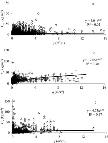
Fig. 3.Sub-hourly instantaneous suspended sediment concentration (Cw in kg m−3; y-axis) versus discharge flow rate (qin m3s−1; x-axis) for(a)Andit Tid,(b)Anjeni, and(c)Maybar.
5.2 t ha−1yr−1for Andit Tid, 24.7 t ha−1yr−1for Anjeni, and 7.4 t ha−1yr−1for Maybar. The sediment concentration aver-ages are greatest when the discharges are small. In the short rainy phase (March–May) of the monsoon in Andit Tid and Maybar, concentrations are elevated, but there is not a con-sistent pattern. During the main rainy phase of the monsoon of all three watersheds, average monthly sediment concen-tration in June is highest and then decreases with time. The sediment load is greatest for the watersheds in either July or August, although sediment concentrations are decreasing, showing that the increase in load is offset by greater increases in discharge (Fig. 2).
Although these average monthly sediment concentrations show a general decrease as the rainy monsoon phase pro-gresses, the sub-hourly data of concentration as a function of discharge does not show a distinct trend (Fig. 3). Us-ing power-type regression to create ratUs-ing curves, i.e., fit-ted equations, showed that Anjeni had the greatest coef-ficient of determination (R2) and that Andit Tid had the lowest, but overall the R2 values were poor at this instan-taneous scale when plotting all data points (indicated by
R2=0.30, 0.17, 0.02 for Anjeni, Maybar, and Andit Tid, respectively). Some researchers attribute low correlation on
this timescale to the hysteretic effect on concentrations dur-ing storms (Glysson, 1987; Walldur-ing, 1977; Asselman, 2000; Williams, 1989) caused by the different concentrations for the rising parts and falling parts of the hydrographs. In some cases, dividing the data into these different parts and plot-ting them separately can negate this effect. Yet, separaplot-ting the data from these watersheds according to the rising and falling limb did not reveal distinguishing patterns on a sub-hourly timescale (not shown). The problem with finding rela-tionships with sub-hourly data is that in general the concen-tration is decreasing as the rainy season progresses but should increase with discharge. Thus, at the same discharge we can have many concentration values depending on whether the storm occurs at the beginning or the end of the rainy season. Also, three distinct areas in Fig. 3 (low flow–high concen-tration, high flow–low concenconcen-tration, and low flow–low con-centration) make it difficult for one rating curve to be fitted to the data. The aforementioned factors give rise to the wide scatter in the plots in Fig. 3, when concentration is plotted against discharge over the whole season. These same factors give rise to low coefficients of determination in the biweekly timescale as well, when plotting all data points together (Ta-ble 2;R2=0.14, 0.23, and 0.02 for Anjeni, Maybar, and An-dit Tid, respectively, in column named “Group” for “ALL” points). Adjusting the biweekly timescale for the cumulative effective precipitation ranges improves the results.
4.2 Rating curves for grouped cumulative effective
precipitation ranges
With the grouping of the runoff events in terms of cumula-tive effeccumula-tive precipitation in the rainy phase, the sediment concentration as a function of discharge shows a distinct trend that is similar for all three watersheds at the biweekly timescale (Fig. 4). For all three watersheds, for a given dis-charge, the concentrations were greater at the beginning of the rainy season with low cumulative effective precipitation,
Pce, (Pce<100 and 100< Pce<300) than near the end of the rainy season (700< Pce<900 andPce>900). Particularly interesting is that the three distinct areas mentioned earlier (low flow–high concentration, high flow–low concentration, and low flow–low concentration) are seen to fall into place according to the different parts of the rainy season (Fig. 4). At the beginning of the rainy season there were low flow– high concentration events, and at the end of the rainy sea-son there were high flow–low concentration events. The low flow–low concentration events occurred throughout the sea-son. This confirms what is seen on the monthly scale (Fig. 2) and shows why a single rating curve is not sufficient for the data (Fig. 3). Within these general trends, for the stratified rating curves, there were still large variations for some of the groupings and results were mixed because the data were taken over a 10–15 yr period in which the land use and con-servation practices changed (Bosshart, 1995). For this rea-son, regression of the data did not yield high correlation
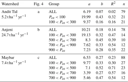
Table 2.Biweekly sediment concentration vs. discharge power regression ofa,b, andR2values for periods with 12 or more observations.
Watershed Fig. 4 Group a b R2 n
Andit Tid a ALL 6.19 0.07 0.02 79
5.2 t ha−1yr−1 P
ce<100 19.99 0.43 0.32 21
100< Pce<300 9.37 0.16 0.16 21
Anjeni b ALL 10.21 0.18 0.14 78
24.7 t ha−1yr−1 100< P
ce<300 19.13 0.32 0.47 14
500< Pce<700 8.3 0.45 0.39 10
700< Pce<900 7.62 0.33 0.54 12
900< Pce 7.23 0.28 0.35 22
Maybar c ALL 6.53 0.27 0.23 88
7.4 t ha−1yr−1 100< P
ce<300 9.77 0.33 0.30 27
300< Pce<500 7.1 0.52 0.71 23
500< Pce<700 3.39 0.27 0.57 16
700< Pce<900 5.46 0.47 0.54 12
for all the sediment rating curves as expected (Table 2, in which the rating curves are presented that had more than 12 observations).
In the three watersheds, theR2values for each group with more than 12 sediment concentration–discharge points vary from 0.16 to 0.76. In the Andit Tid watershed, there are 2 groupings for which the R2 is higher than 0.40 (0.45 for within 300 mm to 500 mmPce; 0.49 for within 500 mm and 700 mmPce), with the rest ranging between 0.08 and 0.33 (Table 2). In Anjeni, the range is from 0.01 to 0.54. The par-ticularly poorR2 for Anjeni occurs in the rating curve for the first 100 mm of cumulative effective precipitation, which is caused by the highly variable concentration values for the top 25 % and bottom 25 % of the biweekly discharge events. Without these, theR2improves to 0.69. In Maybar, the range of R2values covers a smaller range from 0.30 to 0.76, al-though this latter coefficient of determination occurs for a rating curve with a negative exponent and small sample size (n=3). With the exception of Anjeni in the 100 mm group-ing of events, this stratification shows improvement over the single rating curve as the rating curves are covering data over less scattered intervals.
The scatter among these groups indicates complex under-lying sediment supply processes. The precipitation ranges above 500 mm, however, do show less scatter, because at this time most of the crops are well established and the plowing has stopped. Thus, the cropland contributes sediment under a more regular pattern for subsequent storms.
5 Discussion
These results have significant implications for modeling and managing erosion. Firstly, they illustrate that these central Ethiopian highland watersheds follow similar early, mid, and late season patterns. Secondly, they show that the wide
variability in suspended sediment concentration can tighten around theoretical rating curves when normalized by the cropping area in the watersheds. Lastly, they suggest that these patterns may follow the sediment supply patterns.
5.1 Similarity of all three watersheds
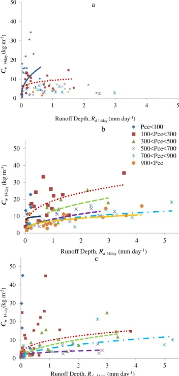
The 14-day average sediment concentrations (Fig. 4) show a clear trend from the beginning of the rainy season to the end. At the beginning of the rainy season (Pce<100 mm), the watersheds were dry after the prolonged dry season and discharges were small. Some average sediment concentra-tions reached up to 45 kg m−3. Discharges were smaller for a given amount of rainfall at the beginning of the rainy pe-riod (Figs. 4, S3 and S4) because these watersheds have soils with infiltration rates greater than the rainfall intensity which can absorb all of the rainfall when not saturated (Bayabil et al., 2010; Engda et al., 2011). Thus, only the few areas that have limited infiltration capacity produced runoff. These ar-eas are characteristically dry at the beginning of the rainy phase with loose soil and, as shown by Defersha et al. (2011), are able to contribute greater amounts of sediment than those contributed from wet soils.
30 1
2
3
4 0 10 20 30 40 50
0 1 2 3 4 5
Cw
14da
y
(k
g
m
-3)
Runoff Depth,Rd14day(mm day-1)
a
30 1
2
3
4
0 10 20 30 40 50
0 1 2 3 4 5
Cw
14da
y
(k
g
m
-3)
Runoff Depth,Rd14day(mm day-1)
b Pce<100
100<Pce<300 300<Pce<500 500<Pce<700 700<Pce<900 900<Pce
31 1
2 3 4 5 6
7
8
9 0 10 20 30 40 50
0 1 2 3 4 5
Cw
14da
y
(k
g
m
-3)
Runoff Depth,Rd 14day(mm day-1)
c
Fig. 4.Fourteen-day averaged storm suspended sediment concen-tration (Cwin kg m−3; y-axis) and runoff depth (Rdin mm day−1; x-axis) for(a)Andit Tid,(b)Anjeni, and(c)Maybar. The regression lines have the same color as the symbols. The regression coefficients andR2values are tabulated in Table 2.
confirm that the concentrations in these watersheds decrease from the beginning of the rainy season to the end (p <0.01). As for the coefficients and exponents in the rating curves, in going from the dry to the wet regime, they only follow partially the trend suggested by Asselman (2000) and Van-maercke et al. (2010). Theacoefficients (Eq. 4) show the
ex-pected general trend downward (but not consistently) as the season progresses (Table 2) and the sediment concentration decreases, however thebexponent does not show the subse-quent upward trend suggested by Vanmaercke et al. (2010) and Asselman (2000) for changing transport dynamics. In-stead, the b exponent stays around the 0.3–0.4 value pro-posed by Ciesiolka et al. (1995) and Yu et al. (1997) for a physically based erosion equation. The authors argue that the valueb=0.4 can be derived by assuming that the ve-locity and the concentration are linearly related in the stream power equation. Then by applying Manning’s equation and assuming that the width of the rill is larger than the depth of flow, the velocity,V, is related to the runoff depth per unit area as
V =k Rd0.4, (5)
wherekis a constant. Thus, the sediment concentration,Cw, is related to the discharge per unit area to the 0.4 power (Ciesiolka et al., 1995; Yu et al., 1997; Tilahun et al., 2011). Our results concerning the rating curves agree partially with studies in Israel and India that did not find a unique function between suspended sediment concentration and dis-charge, speculating that the spatial and temporal variation in sediment supply could explain variations in concentra-tion (Powell et al., 1996; Alexandrov et al., 2003; Sharma et al., 1984). Possible processes that explain supply varia-tion and the pattern displayed in these figures are the ex-haustion of readily available soil from the land and growth of vegetative cover. In addition, Hairsine and Rose (1991) report that during individual storms a protective layer of soil can form to limit detachment of sediment particles, and Sander et al. (1996) found that initial high sediment concen-trations have a much greater fraction of fine sediments than later concentration values. However, when we tried to find this protective layer under natural conditions, we could not find it (not shown). Thus, this mechanism likely cannot ex-plain the decrease in sediment concentration and we are left with decreasing sediment supply and changing plant cover as explainable variables in the Ethiopian highlands. These trends could better explain the shifting pattern for the sedi-ment concentration–discharge relationships during different parts of the rainy season as sediments become less readily available for transport.
5.2 Impact of cropland
During the early rainfall period, agricultural activity is great-est in terms of soil disturbance (Zeleke and Hurni, 2001). The beginning of the rainy season is when plowing and sowing is prevalent for the rain-fed crops of the highlands. Tillage disturbs the soil structure and produces loose aggregates li-able to be carried away by storm runoff (Desta et al., 2000; Nyssen et al., 2000). Our hypothesis is that the sediment con-centration in the runoff water is elevated at the beginning of the season mainly due to the many fields that have been
plowed in the period between that last rainfall of the previous season and the first rains of the following season. Thus, the high sediment concentrations reflect the abundant supply of sediments from the many freshly plowed fields, and they are variable because concentration depends on the erodibility of the soil and the erosivity of the storms. In Anjeni and May-bar, whereEragrostis tef is planted, (SCRP, 2000b, 2001; Haile et al., 2006) sowing of this crop usually occurs later, and consequently, some fields undergo tillage well within the rainfall season and no full plant cover is established by the time that concentrations are decreasing in early August (Zegeye et al., 2010; Tebebu et al., 2010).
To examine if the cropland (plowed with the traditional Maresha plow) can be the main source of the sediment, the data of the three watersheds are normalized with respect to the amount of cropland as follows: (a) all the sediment is as-sumed to originate from the cropland and the sediment con-tribution from the remaining vegetated portion of the water-shed is negligible; (b) the sediment concentration from the cropland can be estimated using Eq. (4) withb=0.4 (Eq. 5, Ciesiolka et al., 1995), also in reasonable agreement with the data in Table 2, and anavalue that is the same for the three watersheds but remains a function of the cumulative rainfall during the rainy phase of the monsoon. Thus, the concentra-tion per unit cropland,Cc(averaged over a 14-day period), is Cc=aPce
c ·R0d.4, (6)
whereaPce
c is a function of the cumulative effective precipi-tationPcesince the beginning of the rainy phase of the mon-soon andRdis the 14-day average storm runoff. Assuming that the remaining areas of the watershed are well protected and do not contribute significantly to the sediment load, the concentration at the watershed outlet,Cw, can then be writ-ten by combining Eq. (4) with Eq. (6), which relates toCc, as
Cw=AcacPce·Rd0.4, (7) whereAc is the fractional cropland area in the watershed. This fraction varies between the watersheds. The Anjeni site has experienced deforestation of nearly all 1957 levels of forest (Hurni et al., 2005) and 80 % is currently cropland (Ac=0.8, Table 1; SCRP, 2001). The Andit Tid site had the least annual average sediment yield, experiencing reforesta-tion since the early 1980s, and currently 30 % of the land is in cultivation (Ac=0.3; Table 1; Yohannes, 1989; Engda et al., 2011). The remaining area not in cropland and forests is covered by bushes and perennial grasses. The Maybar site has the least average rainfall and an intermediate amount of land that is cultivated (60 %) compared to the other sites (Ac=0.60; Table 1; Hurni et al., 2005; Liu et al., 2008).
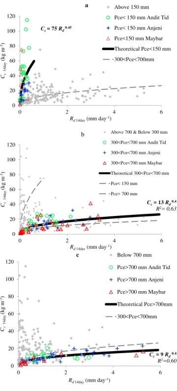
To test if the fraction of cropland can normalize the data, we re-plotted the 14-day average storm sediment concen-tration data of Fig. 4 adjusted according to the fractional cropland area according to Eq. (7) (Fig. 5). In the figures,
32 1
2
0 20 40 60 80 100 120
0 2 4 6
Cc
14da
y
(k
g
m
-3)
Rd14day(mm day-1)
Above 150 mm
Pce< 150 mm Andit Tid
Pce< 150 mm Anjeni
Pce<150 mm Maybar
Theoretical Pce<150 mm
300<Pce<700mm
a
Cc= 75Rd0.45
0 20 40 60 80 100 120
0 2 4 6
Cc
14da
y
(k
g
m
-3)
Rd14day(mm day-1)
Above 700 & Below 300 mm
300<Pce<700 mm Andit Tid
300<Pce<700 mm Anjeni
300<Pce<700 mm Maybar
Theoretical 300<Pce<700 mm
Pce< 150 mm
Pce> 700 mm b
Cc= 13Rd0.4
R2= 0.63
1
2
3 4 5 6
7
8
0 20 40 60 80 100 120
0 2 4 6
Cc
14da
y
(k
g
m
-3)
Rd14day(mm day-1)
Below 700 mm
Pce>700 mm Andit Tid
Pce>700 mm Anjeni
Pce>700 mm Maybar
Theoretical Pce>700mm
300<Pce<700mm
c
Cc= 9Rd0.4
R2=0.60
Fig. 5.Andit Tid, Anjeni, and Maybar average storm sediment con-centration per unit cropland (Ccin kg m−3; y-axis) and runoff depth (Rdin mm day−1; x-axis) over a 14-day period during the rainy phase of the monsoon:(a)early part,(b)middle part, and(c)late part. The ranges of cumulative effective precipitation are given in the legends.
three separate plots from the very early part of the rainy season (Pce<150; Fig. 5a), the middle part of the rainy season (300< Pce<700; Fig. 5b), and the late part of the rainy season (Pce>700; Fig. 5c) are depicted. For each of the cases we draw a theoretical rating curve through the points according to Eq. (6). Theacoefficients decrease ac-cording to the theoretical shift in mobilization of sediments described earlier from 75 to 13 to 9 and the equations are shown in Fig. 5. The exponent for the early part was adjusted to 0.45, rising just above 0.4, which according to Ciesiolka et al. (1995), Paningbatan et al. (1995) and Sombatpanit et al. (1995) occurs when processes other than flow-driven ero-sion contribute significantly to the sediment supply, i.e., gully formation, tillage, rain-drop impact erosion, etc. The coef-ficients of determination for these theoretical rating curve equations become quite good atR2=0.40, 0.63, and 0.60 for the early, middle, and late rainfall periods, respectively. It should be mentioned that theseR2 values for the com-bined plots are better than the previous separate plots for each of the watersheds, in part because we selected differ-ent rainfall boundaries for the various plots and we removed the outliers within these data boundaries. The outliers were determined by considering the values outside of the 95 % prediction interval of the ordinary least squares regression of the log-transform values. For the early period (Pce<150), concentration values for discharge were limited to discharges below 0.45 mm day−1as flows above this were more indica-tive of the transition between the early and mid-rainfall pe-riod. Nearing (1998) indicates that due to the practical lim-itations in predicting an erosional system, physical models would not be expected to have better overall results than
R2=0.76. Also, high variability is to be expected with the many years of changing land use in these watersheds. The mean square error for the theoretical rating curves decreases consistently from the early rainfall rating curve to the late rainfall rating curve. Consequently, basing the exponent on the physically based derivations of Ciesiolka et al. (1995) and Yu et al. (1997) and normalizing by fractional crop-land has improved the fit andR2 of the rating curves. The sediment concentration–discharge points become now quite tight around the theoretical rating curve line, especially when compared to initial sediment concentration data plotted as a function of runoff amounts (Fig. 2).
5.3 Implications of the findings
Contrary to a general increase in sediment concentration for increasing discharge according to a single rating curve as observed for temperate climates, where soils seldom com-pletely dry out, for monsoon climates it must be taken into account that concentrations are generally decreasing as the rainy phase progresses. The time frame for which the sediment concentration is being estimated matters. Models that take this general pattern of decrease in concentrations into account will have a greater ability to track suspended
sediment concentration changes throughout the rainy season than models that attribute sediment concentration variability to crop type only. As shown by Zegeye et al. (2010) during erosion measurements for different land uses, the sediment concentrations decrease all at the same time almost indepen-dent of the crop cover type.
As a final point, similar decreases in sediment concentra-tion as observed for these three watersheds have been ob-served at the border with Sudan in the main stem of the Blue Nile (Easton et al., 2010). Thus, it would seem that the Blue Nile itself does not compensate by picking up more sediment from its banks when the sediment concentrations are low. Therefore, these results suggest that decreasing the sediment contributions from the cropland areas in which the runoff is being produced might also decrease sediment concentrations in the main stem of the Blue Nile. However, more research is needed on what practices are effective.
6 Conclusions
By studying the suspended sediment dynamics at the outlet of three watersheds, the role of storm runoff in determining suspended sediment concentration was assessed. Higher con-centrations for low flows and lower concon-centrations for high flows in the whole data set made the use of a single rating curve impractical. However, the high variability in concen-tration led to analysis on longer timescales and stratifica-tion of data in order to attempt to describe the high and low concentration values. A division of the seasons into mois-ture conditions (cumulative effective precipitation ranges) in-creased theR2for sediment rating curves that were created on a biweekly scale for average discharge. Also, it was shown that the high concentration–low flow events occurred for the rating curves calculated for the beginning of the rainy sea-son (Pce<100 mm), whereas low concentration–high flow events occurred for rating curves calculated for the end of the rainy season (Pce>700 mm). Thus, by grouping sediment concentrations into periods of different moisture regimes for the watersheds, possible explanations arise for decreasing concentrations throughout the main rainy monsoon phase. Based on these similarities and to account for the decrease, theoretical rating curves based on normalization of fractional cropland for each part of the rainy season (early, middle, late) were calculated, which led to one set of parameters that could be used for the three watersheds. Models that incorpo-rate such parameters to account for the seasonal decrease in sediment concentrations will be more effective in estimating sediment transport in rivers in the Ethiopian highlands.
Supplementary material related to this article is
available online at: http://www.hydrol-earth-syst-sci.net/ 17/1067/2013/hess-17-1067-2013-supplement.pdf.
Acknowledgements. Funding for C. D. Guzman was made avail-able through the State University of New York Diversity Fellowship and the Food Systems and Poverty Reduction IGERT program at Cornell University through the National Science Foundation. This study was made possible by the hydrological and sediment data provided by the Amhara Regional Agricultural Research Institute (ARARI) and the special assistance given by the faculty and staff of Bahir Dar University. Recognition is also due to the initiators of the Soil Conservation Research Programme (SCRP) and their local research assistants who had the dedication, day and night, to collect data in all conditions of weather. Finally, we would like to thank H. Hurni for his foresight in establishing these research watershed sites.
Edited by: P. Grathwohl
References
Alexandrov, Y., Laronne, J. B., and Reid, I.: Suspended sediment concentration and its variation with water discharge in a dryland ephemeral channel, northern Negev, Israel, J. Arid Environ., 53, 73–84, 2003.
Asselman, N. E. M.: Fitting and interpretation of sediment rating curves, J. Hydrol., 234, 228–248, 2000.
Awulachew, S. B.: Improved water and land management in the Ethiopian highlands and its impact on downstream stakeholders dependent on the Blue Nile, CPWF Project Number 19, CGIAR Challenge Program on Water and Food Project Report series, www.waterandfood.org (last access: 6 July 2011), 2010. Bayabil, H. K., Tilahun, S. A., Collick, A. S., and Steenhuis, T. S.:
Are runoff processes ecologically or topographically driven in the (sub) humid Ethiopian highlands? The case of the Maybar watershed, Ecohydrol., 3, 457–466, doi:10.1002/eco.170, 2010. Bosshart, U.: Catchment discharge and suspended sediment
trans-port as indicators of physical soil and water conservation in the Minchet catchment, Gojam Research Unit: A case study in the north-western Highlands of Ethiopia, Soil Conserva-tion Research Programme Research Report, University of Bern, Switzerland, 1995.
Bosshart, U.: Measurement of river discharge for the SCRP re-search catchments: Gauging station profiles, Soil Conservation Research Programme Research Report 31, University of Bern, Switzerland, 1997.
Ciesiolka, C. A., Coughlan, K. J., Rose, C. W., Escalante, M. C., Hashim, G. M., Paningbatan, E. P., and Sombatpanit, S.: Method-ology for a multi-country study of soil erosion management, Soil Technol, 8, 179–192, doi:10.1016/0933-3630(95)00018-6, 1995. Defersha, M. B., Quraishi, S., and Melesse, A.: The effect of slope steepness and antecedent moisture content on interrill erosion, runoff and sediment size distribution in the highlands of Ethiopia, Hydrol. Earth Syst. Sci., 15, 2367–2375, doi:10.5194/hess-15-2367-2011, 2011.
Desta, L., Kassie, M., Benin, S., and Pender, J.: Land degradation and strategies for sustainable development in the Ethiopian high-lands, Amhara Region, Socio-economics and Policy Research Working Paper 32, International Livestock Research Institute, Nairobi, Kenya, 2000.
Easton, Z. M., Fuka, D. R., White, E. D., Collick, A. S., Biruk Asha-gre, B., McCartney, M., Awulachew, S. B., Ahmed, A. A., and
Steenhuis, T. S.: A multi basin SWAT model analysis of runoff and sedimentation in the Blue Nile, Ethiopia, Hydrol. Earth Syst. Sci., 14, 1827–1841, doi:10.5194/hess-14-1827-2010, 2010. Engda, T. A., Bayabil, H. K., Legesse, E. S., Ayana, E. K., Tilahun,
S. A., Collick, A. S., Easton, Z. M., Rimmer, A., Awulachew, S. B., and Steenhuis, T. S.: Watershed hydrology of the (semi) hu-mid Ethiopian Highlands, in: Nile River Basin: Hydrology, Cli-mate and Land Use, edited by: Melesse, A., Springer Science Publisher, New York, USA, 145–162, 2011.
ETHIO-GIS (Ethiopian Geographical Information System): A geo-referenced database and digital terrain model of Ethiopian spatial information prepared in a geographical information system (GIS) database, CDE, Centre for Development and Environment, Uni-versity of Bern, Switzerland, 2004.
Eweg, H. P. A., Van Lammeren, R., Deurloo, H., and Woldu, Z.: An-alyzing degradation and rehabilitation for sustainable land man-agement in the highlands of Ethiopia, Land Degrad. Dev., 9, 529– 542, 1998.
Glysson, D.: Sediment-transport curves, Open-File Report 87-218, US Geological Survey, Virginia, USA, 1987.
Grunder, M.: Soil conservation research in Ethiopia, Mt. Res. Dev., 8, 145–151, 1988.
Haile, M., Herweg, K., and Stillhardt, B.: Sustainable land man-agement – A new approach to soil and water conservation in Ethiopia, Land Resources Management and Environmental Pro-tection Department, Mekelle University, Mekelle, Ethiopia; Cen-tre for Development and Environment (CDE), University of Bern, and Swiss National Centre of Competence in Research (NCCR) North-South, Bern, Switzerland, 269 pp., 2006. Hairsine, P. B. and Rose, C. W.: Rainfall detachment and deposition:
Sediment transport in the absence of flow-driven processes, Soil Sci. Am. J., 55, 320–324, 1991.
Haregeweyn, N. and Yohannes, F.: Testing and evaluation of the agricultural non-point source pollution model (AGNPS) on Au-gucho catchment, Western Hararghe, Ethiopia, Agr. Ecosyst. En-viron., 99, 201–212, 2003.
Herweg, K. and Ludi, E.: The performance of selected soil and wa-ter conservation measures- case studies from Ethiopia and Er-itrea, Catena, 36, 99–114, 1999.
Hurni, H.: The third progress report. Soil conservation research project, Vol. 4., University of Bern and the United Nations Uni-versity, Ministry of Agriculture, Addis Ababa, Ethiopia, 1984. Hurni, H.: Soil Conservation Manual for Ethiopia, Soil
tion Research Project, Community Forest and Soil Conserva-tion Development Department, Natural Resources ConservaConserva-tion, 1985.
Hurni, H.: Degradation and conservation of the resources in the Ethiopian highlands, Mt. Res. Dev., 8, 123–130, 1988.
Hurni, H., Kebede, T., and Gete, Z.: The implications of changes in population, land use, and land management for surface runoff in the upper Nile basin area of Ethiopia, Mt. Res. Dev., 25, 147– 154, 2005.
Legesse, E. S.: Modeling rainfall-runoff relationships for the Anjeni watershed in the Blue Nile basin, M.P.S. Thesis, Cornell Univer-sity, Ithaca, NY, USA, 2009.
Lootens, M. and Lumbu, S.: Suspended sediment production in a suburban tropical basin (Lumbumbashi, Zaire), Hydrolog. Sci. J., 31, 39–49, 1986.
Mohammed, A., Yohannes, F., and Zeleke, G.: Validation of agricul-tural non-point source (AGNPS) pollution model in Kori water-shed, South Wollo, Ethiopia, Int. J. Appl. Earth Obs., 6, 97–109, 2004.
Mulugeta, T.: Soil conservation experiments on cultivated land in the Maybar area, Wello Region, Ethiopia, Soil conservation re-search project, Rere-search Report 16, University of Bern, Switzer-land, 127 pp., 1988.
Nearing, M. A.: Why soil erosion models over-predict small soil losses and under-predict large soil losses, Catena, 32, 15–22, 1998.
Nyssen, J., Poesen, J., Haile, M., Moeyersons, J., and Deckers, J.: Tillage erosion on slopes with soil conservation structures in the Ethiopian highlands, Soil Till. Res., 57, 115–127, 2000. Nyssen, J., Poesen, J., Moeyersons, J., Deckers, J., Haile, M., and
Lang, A.: Human impact on the environment in the Ethiopian and Eritrean Highlands – a state of the art, Earth Sci. Rev., 64, 273–320, 2004.
Nyssen, J., Poesen, J., Moeyersons, J., Haile, M., and Deckers, J.: Dynamics of soil erosion rates and controlling factors in the northern Ethiopian highlands – towards a sediment budget, Earth Surf. Proc. Land., 33, 695–711, 2008.
Paningbatan, E. P., Ciesiolka, C. A., Coughlan, K. J., and Rose, C. W.: Alley cropping for managing soil erosion of hilly lands in the Philippines, Soil Technol., 8, 193–204, doi:10.1016/0933-3630(95)00019-4, 1995.
Powell, D. M., Reid, I., Laronne, J. B., and Frostick, L. E.: Bedload as a component of sediment yield from a semiarid watershed of the northern Negev, in: Proceedings of the Symposium on Ero-sion and Sediment Yield: Global and Regional Perspectives, Int. Assoc. Hydrol. Sci. Publ., Exter, UK, 236, 389–397, 1996. Sander, G. C., Hairsine, P. B., Rose, C. W., Cassidy, D., Parlange, J.
Y., Hogarth, W. L., and Lisle, I. G.: Unsteady soil erosion model, analytical solutions and comparison with experimental results, J. Hydrol., 178, 351–367, 1996.
Setegn, S. G., Ragahavan, S., and Bijan, D.: Hydrological modelling in the Lake Tana Basin, Ethiopia using SWAT model, Open Hy-drol. J., 2, 49–62, 2008.
Setegn, S. G., Rayner, D., Melesse, A. M., Dargahi, B., and Srini-vasan, R.: Impact of climate change on the hydroclimatology of Lake Tana Basin, Ethiopia, Water Resour. Res., 47, W04511, doi:10.1029/2010WR009248, 2011.
Sharma, K. D., Vangani, N. S., and Choudhari, J. S.: Sediment trans-port characteristics of desert streams in India, J. Hydrol., 67, 261–272, 1984.
Soil Conservation Research Programme (SCRP): Area of Andit Tid, Shewa, Ethiopia: Long-term monitoring of the agricultural envi-ronment 1981–1994, Soil Erosion and Conservation Database, Center for Development and Environment, University of Bern, Switzerland; The Ministry of Agriculture, Ethiopia, 2000a. Soil Conservation Research Programme (SCRP): Area of Maybar,
Wello, Ethiopia: Long-term monitoring of the agricultural envi-ronment 1981–1994, Soil Erosion and Conservation Database, Center for Development and Environment, University of Bern, Switzerland; The Ministry of Agriculture, Ethiopia, 2000b.
Soil Conservation Research Programme (SCRP): Area of Anjeni, Gojam, Ethiopia: Long-term monitoring of the agricultural en-vironment 1981–1994, Soil Erosion and Conservation Database, Center for Development and Environment, University of Bern, Switzerland; The Ministry of Agriculture, Ethiopia, 2001. Sombatpanit, S., Rose, C. W., Ciesiolka, C. A., and Coughlan, K. J.:
Soil and nutrient loss under rozelle (Hibiscus subdariffa L. var. altissima) at Khan Kaen, Thailand, Soil Technol., 8, 235–241, 1995.
Tebebu, T. Y., Abiy, A. Z., Zegeye, A. D., Dahlke, H. E., Easton, Z. M., Tilahun, S. A., Collick, A. S., Kidnau, S., Moges, S., Dadgari, F., and Steenhuis, T. S.: Surface and subsurface flow ef-fect on permanent gully formation and upland erosion near Lake Tana in the northern highlands of Ethiopia, Hydrol. Earth Syst. Sci., 14, 2207–2217, doi:10.5194/hess-14-2207-2010, 2010. Tilahun, S. A., Mukundan, R., Demisse, B. A., Guzman, C.,
Tarakegn, B. C., Engda, T. A., Easton, Z. M., Collick, A. S., Zeg-eye, A. D., Schneiderman, E. M., Parlange, J. Y., and Steenhuis, T. S.: A saturation excess erosion model, International Sympo-sium on Soil Erosion and Landscape Evolution, Specialty Con-ference of the American Society of Agricultural and Biological Engineering, Anchorage, Alaska, USA, 19–24 September 2011, ISELE Paper Number 11061, 2011.
Vanmaercke, M., Zenebe, A., Poesen, J., Nyssen, J., Vertstraeten, G., and Deckers, J.: Sediment dynamics and the role of flash floods in sediment export from medium-sized catchments: a case study from the semi-arid tropical highlands in northern Ethiopia, J. Soil. Sediment., 10, 611–627, 2010.
Walling, D. E.: Assessing the accuracy of suspended sediment rat-ing curves for a small basin, Water Resour. Res., 13, 531–538, 1977.
White, E. D., Easton, Z. M., Fuka, D. R., Collick, A. S., Adgo, E., McCartney, M., Awulachew, S. B., Selassie, Y., and Steenhuis, T. S.: Development and application of a physically based landscape water balance in the SWAT model, Hydrol. Process., 23, 3728– 3737, doi:10.1002/hyp.7876, 2010.
Williams, G. P.: Sediment concentration versus water discharge dur-ing sdur-ingle hydrological events in rivers, J. Hydrol., 111, 89–106, 1989.
Yohannes, G.: Land use, agricultural production and soil conserva-tion methods in the Andit Tid area, Shewa Region, Soil Conser-vation Research Project, Research Report 17, University of Bern in association with the United Nations University, Bern, Switzer-land, 151 pp., 1989.
Yu, B., Rose, C. W., Ciesiolka, C. A., Coughlan, K. J., and Fentie, B.: Toward a framework for runoff and soil loss prediction using GUEST technology, Aust. J. Soil Res., 35, 1191–1212, 1997. Zegeye, A. D., Steenhuis, T. S., Blake, R. W., Kidnau, S., Collick,
A. S., and Dadgari, F.: Assessment of soil erosion processes and farmer perception of land conservation in Debre Mewi watershed near Lake Tana, Ethiopia, Ecohydrol. Hydrobiol., 10, 297–306, 2010.
Zeleke, G.: Landscape dynamics and soil erosion processes mod-eling in the north-western Ethiopian highlands, Ph.D. thesis, In-stitute of Geography, University of Bern, Switzerland, 201 pp., 2000.
Zeleke, G. and Hurni, H.: Implications of land use and land cover dynamics for mountain resource degradation in the northwestern Ethiopian highlands, Mt. Res. Dev., 212, 184–191, 2001.