The Blurred Line between Form and Process:
A Comparison of Stream Channel
Classification Frameworks
Alan Kasprak1¤‡
*, Nate Hough-Snee1,2‡
*, Tim Beechie3☯‡, Nicolaas Bouwes4☯‡,
Gary Brierley5☯‡
, Reid Camp1,4☯‡
, Kirstie Fryirs6☯‡
, Hiroo Imaki7☯‡
, Martha Jensen1,2☯‡
, Gary O’Brien1☯‡, David Rosgen8☯‡, Joseph Wheaton1,2☯‡
1Department of Watershed Sciences, Utah State University, Logan, UT 84322–5210, United States of America,2Ecology Center, Utah State University, Logan, UT, 84322–5210, United States of America, 3Fish Ecology Division, Northwest Fisheries Science Center, National Marine Fisheries Service, National Oceanic and Atmospheric Administration, Seattle, WA 98112, United States of America,4Eco Logical Research, Providence, UT, United States of America,5School of Environment, University of Auckland, Auckland, New Zealand,6Department of Environmental Sciences, Macquarie University, Sydney, Australia, 7Pacific Spatial Solutions, Reston, VA, United States of America,8Wildland Hydrology, Fort Collins, CO, 80524, United States of America
☯These authors contributed equally to this work.
¤ Current address: U.S. Geological Survey, Grand Canyon Monitoring and Research Center, Flagstaff, AZ,
86001, United States of America
‡AK and NH-S are joint lead authors on this work. TB, NB, GB, RC, KF, HI, MJ, GO, DR and JW are presented alphabetically on this work.
*[email protected](AK);[email protected](NH-S)
Abstract
Stream classification provides a means to understand the diversity and distribution of chan-nels and floodplains that occur across a landscape while identifying links between geomor-phic form and process. Accordingly, stream classification is frequently employed as a watershed planning, management, and restoration tool. At the same time, there has been intense debate and criticism of particular frameworks, on the grounds that these frameworks classify stream reaches based largely on their physical form, rather than direct measure-ments of their component hydrogeomorphic processes. Despite this debate surrounding stream classifications, and their ongoing use in watershed management, direct compari-sons of channel classification frameworks are rare. Here we implement four stream classifi-cation frameworks and explore the degree to which each make inferences about
hydrogeomorphic process from channel form within the Middle Fork John Day Basin, a watershed of high conservation interest within the Columbia River Basin, U.S.A. We com-pare the results of the River Styles Framework, Natural Channel Classification, Rosgen Classification System, and a channel form-based statistical classification at 33 field-moni-tored sites. We found that the four frameworks consistently classified reach types into simi-lar groups based on each reach or segment’s dominant hydrogeomorphic elements. Where classified channel types diverged, differences could be attributed to the (a) spatial scale of input data used, (b) the requisite metrics and their order in completing a framework’s deci-sion tree and/or, (c) whether the framework attempts to classify current or historic channel a11111
OPEN ACCESS
Citation:Kasprak A, Hough-Snee N, Beechie T, Bouwes N, Brierley G, Camp R, et al. (2016) The Blurred Line between Form and Process: A Comparison of Stream Channel Classification Frameworks. PLoS ONE 11(3): e0150293. doi:10.1371/journal.pone.0150293
Editor:Julia A. Jones, Oregon State University, UNITED STATES
Received:November 25, 2015
Accepted:February 11, 2016
Published:March 16, 2016
Copyright:This is an open access article, free of all copyright, and may be freely reproduced, distributed, transmitted, modified, built upon, or otherwise used by anyone for any lawful purpose. The work is made available under theCreative Commons CC0public domain dedication.
Data Availability Statement:Data in this manuscript can be accessed athttp://figshare.com/s/
9e02827a92fc11e5adb406ec4b8d1f61.
Funding:Support for this manuscript was provided by grants from the Bonneville Power Administration to Eco Logical Research (BPA Project Number: 2003-017), Inc. and subsequent grants from ELR to Utah State University (USU Award ID: 100652). NH-S was supported in part by STAR Fellowship Assistance
Agreement no. 91768201–0 awarded by the U.S.
form. Divergence in framework agreement was also observed at reaches where channel planform was decoupled from valley setting. Overall, the relative agreement between frame-works indicates that criticism of individual classifications for their use of form in grouping stream channels may be overstated. These form-based criticisms may also ignore the geo-morphic tenet that channel form reflects formative hydrogeogeo-morphic processes across a given landscape.
Introduction
The physical form of a stream channel is the result of the coupled climatic, biotic, and hydro-geomorphic processes acting upon it [1,2,3]. Accordingly, the classification of rivers into reach types based on their physical characteristics lends insight into both the formative processes that shape rivers, and the diversity of rivers that occur across an area of interest [3,4]. There are numerous frameworks for classifying streams, many of which have diverse spatial and tempo-ral output scales (see [5,6,7]). Classification applications range from river maintenance to flood control to channel and riparian protection from land use [8], and more broadly help to disen-tangle natural and anthropogenic influences on channels, determine current channel condi-tion, and forecast response to future disturbance [3]. Over the past two decades, there has been intense debate and criticism of the utility of particular frameworks [9,10,11,12,13], largely in the context of river management and restoration. These criticisms range from the limitations of a given framework at some spatial and temporal scales, to criticisms of the decisions that can arise when a framework is misapplied, to the fact that most frameworks lack measurements of process rates (e.g. sediment flux, bank migration) and process must instead be inferred from channel form. An unfortunate effect of these criticisms is that river classification frameworks, regardless of their utility, have been overlooked not for what they provide, but for perceptions of classifications’past (mis)applications.
The discussion of individual stream classification frameworks has been subsumed in a broader conversation [12,14,15] that differentiates frameworks in terms of whether they are
‘form-based’or‘process-based.’Form- based frameworks, those that classify stream reaches based on their physical attributes, are often criticized as being overly simplistic. Yet to criticize frameworks on the notion that they are‘onlyform-based’is to ignore a basic tenet of geomor-phology: thatform implies process[3]. That is, measurements of river form are direct reflections of the processes acting to shape that form [1,2,16,17]. Indeed, nearly all classification frame-works use metrics that describe the capacity of a channel to perform geomorphic work and adjust laterally within a valley bottom. For example, many classifications include measures of channel gradient, valley setting or entrenchment, and sediment characteristics [6,18,19,20]. The fundamental basis of geomorphology is concerned both with landforms and the processes that shape them. While the focus on quantifying process has helped geomorphology mature beyond its observational and empirical roots [21], the notion that the study of form, or infer-ence about process from form, is inherently flawed is short-sighted. This over-simplification implies that form and process are at best, distinct, and at worst, mutually exclusive. In reality, the line between form and process is blurred, as river form and hydrogeomorphic processes are directly related.
In a long history of disagreement between proponents and detractors of particular classifica-tion frameworks, and over the relative utility of form- versus process-based classificaclassifica-tion in general, it is of note that direct comparisons of frameworks are exceedingly rare [11,22,23,24].
NOAA or BPA and the views expressed herein are solely those of the authors. The EPA, NOAA, and BPA do not endorse any products or commercial services mentioned in this publication. The funders had no role in study design, data collection or analysis, decision to publish, or preparation of the manuscript.
This may be due to the inherent difficulty in comparing methodologies that produce results at different spatial scales and which seek to describe past or present river condition. These meth-odologies also often require disparate types and amounts of input data and varying degrees of geomorphic expertise to complete. Nevertheless, the geomorphic community would benefit from a more clear understanding of the degree to which various river classifications, which dif-fer in whether or how they include or indif-fer process from form, reach similar or disparate con-clusions with regard to their output [3].
This paper applies four classification frameworks across a watershed of high conservation interest in the Pacific Northwest, USA (Table 1). Each of these frameworks contains, to varying degrees, metrics that reflect the form of channels and floodplains, and/or the processes operat-ing upon those channels and floodplains. Our goal is to performthe first direct comparisons of classification frameworks at the watershed scale, and in so doing, to elucidate the reasons for similarities and differences between classification outputs. Where frameworks differ in the geomorphic attributes (e.g. channel planform, bed material, valley confinement) of their out-put, we attempt to ascertain the methodological differences that lead to divergence in classifica-tion. Herein we focus on theRiver Styles Framework(RSF; [6]), theNatural Channel
Classificationsystem (NCC; developed byBeechie and Imaki[25]), and theRosgen Classifica-tion System(RCS; [26,27]). We contrast these with an example of a flexiblestatistical classifica-tionapproach that clusters field-measured, reach-scale data into channel-form-based groups (Table 1). The RSF and RCS are commonly applied in Australian and North American stream and watershed assessments, respectively. The NCC framework, as presented here, uses ele-ments of the Montgomery and Buffington classification [20] to create a network of pre-distur-bance channel types across the U.S. Pacific Northwest [20]. Statistical classification is a flexible family of approaches to grouping stream channels, and is increasingly common in geomor-phology (e.g. [28]), hydrology (e.g. [29]) and ecology (e.g. [30]) for identifying patterns among observations. These frameworks have been selected because of (a) their popularity in the geo-morphology and aquatic habitat communities, (b) the wide spatiotemporal range of their out-puts, and (c) the varying degrees to which they directly or indirectly account for processes operating on river systems (Table 1).
Methods
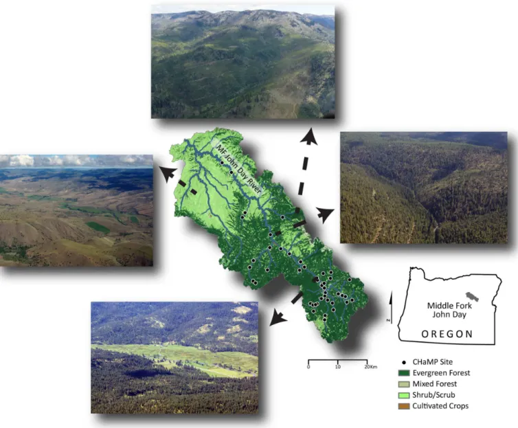
The Middle Fork of the John Day River (MFJD; Oregon, USA) is 117 km long and drains 2051 km2within the broader Columbia River Basin (Fig 1). The MFJD watershed was chosen for this research both for its physiographic diversity and due to the wealth of stream data available there, largely as a result of ongoing watershed monitoring aimed at understanding physical fac-tors limiting salmonid population resilience (Section 2.2). These data enabled completion of the four classification frameworks herein (Table 1; Sections 2.3–2.6).
Landscape, hydrologic, and ecological setting
Salmonid conservation and watershed monitoring
Reductions in native fish populations throughout the Columbia River Basin, including the MFJD, have led to large-scale aquatic habitat monitoring across the region. In particular, steel-head trout (Oncorhynchus mykiss), listed as threatened under the U.S. Endangered Species Act, have seen drastic reductions in the size of their runs [45] as a direct effect of anthropogenic
Table 1. Summaries of the four classification frameworks applied to streams of the Middle Fork John Day River Basin: River Styles, Natural Chan-nel Classification, Rosgen Classification System, and statistical classification.
Classification Framework (abbreviation)
Description Examples Data requirements Classified output References
River Styles Framework (RSF)
A hierarchical, multi-scale classification scheme for describing river character and behavior. River Styles can be used to
understand river condition, recovery potential and prioritize management.
Use in river management practice across NSW, Australia [6,31,32]; Correlates to downstream sediment storage and landscape connectivity [33,34,35,36,37]; Ecological community composition varies as a function of River Styles [38,39]
Field, remote-sensing and other GIS data on geology, hydrology, and stream geomorphic setting to identify broad-scale to local controls on river character and behavior.
Continuous stream network (NHD+)
[6,31,32,40]
Columbia Basin Natural Channel Classification (NCC)
NCC is a model-based stream classification using a machine-learning (support vector machine) algorithm to group reaches based on their historic, undisturbed planform. Divides reaches into groups based on channel width before sub-dividing on reach-level remote sensing data.
A historic planform map and dataset for the Columbia River Basin [25]
Remotely-sensed channel slope, discharge, valley confinement, sediment supply, and sediment size are used as predictors of channel planform in a modeling framework.
Continuous, pre-disturbance stream network (NHD)
[25]
Rosgen Classification System (RCS)
RCS is a stream-reach taxonomy based onfi eld-collected empirical data that classifies geomorphic stream features to identify stream types by
numerically bounded physical metrics. This is arguably the most commonly used stream classification system in North America and the world.
RCS can be employed to successfully restore a reach to a reference condition, provided that the reference reach is stable [41]; RCS stream type classifications provide inferences into the sensitivity of stream reaches to natural channel changes [42]
Valley morphology for broad context, and reach-scale monitoring data to calculate basic dimensionless metrics linking form to physical processes.
Individual reaches within a stream network (fi eld-monitored reaches)
[26,27]
Statistical Classification (SC)
Statistical classification refers to any classification methods used to differentiate or group stream reaches,
watersheds, etc. based on multiple physical, chemical, and/or biological attributes. Attributes are often selected for their role in driving or responding to dominant processes within a catchment.
Comparing restored, forested, and urban channels [43]; Identifying vegetation communities and environmentalfilters [30]; classification of desert washes [28]
Requires reach-scale monitoring data for “bottom-up”classifications. Requires remote sensing and GIS data to classify reaches from the “top-down”or correlate classified reaches to larger-scale environmental or physical processes.
Individual reaches within a stream network (fi eld-monitored reaches). Can be applied to networks if inputs are available for stream segments or networks.
[3,28,30]
habitat degradation, in part due to hydropower development, land use change, and direct chan-nel modification such as loss of large woody debris [46]. As a result, watersheds throughout the Columbia River Basin have received intensive monitoring efforts to document the status and trend of fluvial habitats that support salmonid populations [47,48].
The MFJD is monitored as part of the Columbia Habitat Monitoring Program (CHaMP;
http://www.champmonitoring.org). CHaMP data, which are used to complete the four classifi-cation frameworks, are collected at wadeable, perennial streams throughout the Columbia River Basin [48]. Reaches were selected for sampling using a generalized random tessellation stratified sampling design to prevent spatial sampling bias [49]. Here we use CHaMP data from the MFJD watershed collected during 2012 and 2013 (n = 33 sites) describing channel
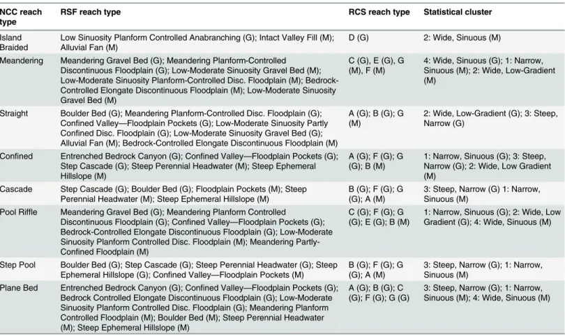
Fig 1. Map of the Middle Fork John Day Basin, Oregon, USA.The 33 Columbia Habitat Monitoring Program (CHaMP) reaches monitored between 2012– 2013 are shown in circles. The National Landcover Dataset is presented as the base map to illustrate biophysical gradients across the watershed. Four photos illustrate the diversity of landscapes encountered across the basin.
bankfull width and depth, gradient, substrate, and sinuosity. CHaMP sampling reaches are twenty times as long as the bankfull channel width at each site (120–360 m in length).
The River Styles Framework
The River Styles framework (Table 1) seeks to provide a“coherent set of procedural guidelines with which to document the geomorphic structure and function of rivers, and appraise patterns of river types and their biophysical linkages in a catchment context”[6]. In practice, the RSF offers the potential for a process-based, watershed-scale classification system for rivers. The RSF consists of four distinct stages that progress from (1) classifying landscapes and current river form and function, to (2) assessing geomorphic river condition in context of reach evolu-tion, to (3) understanding and forecasting trajectories of river change, and (4) prioritizing catchment management. A full description of the methods entailed in the RSF can be found in [6]. Here we describe the application of stage one of the RSF, which has been completed for the MFJD as part of an ongoing effort to contextualize site-specific CHaMP monitoring data in a watershed setting [50]. Stage one provides a baseline assessment of current reach types (referred to as‘river styles’) in a system with emphasis on longitudinal variability of river form (i.e. longitudinal profile analyses) along the mainstem channel and tributary network.
The RSF begins with the classification of landscape units (Fig A inS1 File), each of which contain a unique distribution of river styles. Within a given landscape unit, stream reaches are classified based on their valley confinement, presence or absence of floodplains, channel plan-form, distribution of in-channel and floodplain geomorphic units, and dominant channel sub-strate (Table 2). In contrast to the other classification systems presented here and those used among practitioners (e.g. [20,26]), there is no intrinsic limit on the number of river styles that may occur in a watershed of interest. In practice, once the diversity of river styles for a particu-lar watershed is known, a river styles tree (Figs B–D inS1 File) can be constructed that allows for the classification of any stream segment from those found in the watershed. The top-level discriminator in the RSF is valley confinement (Figs B–D inS1 File), which Brierley and Fryirs [6] define as“the proportion of the channel length that abuts a confining margin on either side”[6].
We used O’Brien and Wheaton’s [50] delineation of river styles for the MFJD where the boundaries between landscape units were defined using remote sensing data including eleva-tion (10 m and 1 m digital elevaeleva-tion models; [51]), slope, underlying geology [52], dominant vegetation [53], and Level IV EcoRegion boundaries [54]. Following the delineation of land-scape units, individual river styles were initially digitized on the National Hydrography Dataset (NHD; as polylines in ArcGIS; ESRI, Redlands, CA) using aerial photos ([55]; 1 m resolution) and elevation datasets as a guide. O’Brien and Wheaton [50] conducted field visits in the sum-mer of 2012 and 2013 to confirm the accuracy of these delineations, refine the distinguishing characteristics of each river style and its location in the river style tree (Figs B–D inS1 File) and pinpoint boundaries between river styles when they could not be delineated using remote sens-ing data.
the channel and can be used to infer reach boundaries [6]. Within each valley setting, river styles are classified based on metrics of channel form that are directly tied to geomorphic pro-cesses like stream discharge and power that govern sediment transport, along with channel planform (including the presence or absence of a channel), the array of instream and floodplain geomorphic units along the reach, and bed material texture (Table 2).
Natural channel classification
Natural channel classification [25] seeks to predict the background, or pre-disturbance, plan-form of alluvial channels found in an area of interest (Table 1). To this end, Beechie and Imaki [25] constructed a probabilistic map of pre-disturbance channel planforms across the Colum-bia River Basin, USA (drainage area 674,500 km2). Channel classes identified in NCC include confinedchannels and four channel patterns for unconfined reaches:straight,meandering, island-braided, andbraided. These four unconfined channel patterns are common planforms for alluvial, floodplain rivers [16,18,75], which have distinctly different morphologies, dynam-ics, and ecological attributes [74,76]. In NCC, confinement is defined as the ratio of bankfull width to valley width, and unconfined channels are those where the valley floor width is more than four times the bankfull width. Predictor variables in the model were based on known physical controls on channel pattern, including channel gradient, discharge, valley confine-ment, sediment supply, and sediment size [77]. Channel slope, discharge, and confinement were estimated from digital elevation models. Relative reach slope, percent of the watershed in
Table 2. Form-based channel metrics included in classification analyses.
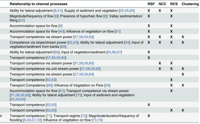
Metric of channel form Relationship to channel processes RSF NCC RCS Clustering
Valley confinement Ability for lateral adjustment [6,61]; Supply of sediment and vegetation [25,56,65] X X X Presence or absence of
channels
Magnitude/frequency offlow [6]; Presence of hyporheicflow [6]; Valley sedimentation/ filling [31]
X X
Number of channels Accommodation space forflow [6] X X
Distribution offloodplains Accommodation space forflow [40]; Influence of vegetation onflow [61] X X Gradient or channel slope Transport competence via stream power [57,58,59,60] X X X X Sinuosity Competence via slope/stream power [62,63]; Ability for lateral adjustment [64]; Input of
vegetation/sediment from banks [65]
X X X X
Lateral channel stability Ability for lateral adjustment [66]; Input of vegetation/sediment [65,66,67] X
Unit stream power Transport competence [57,58,59,60] X
Site discharge Transport competence via stream power [57,58,59,60] X X
Bankfull width Transport competence via unit stream power [57,58,59,60] X X X
Wetted width Transport competence via stream power [57,58,59,60] X
Bankfull depth Transport competence [62,63] X
Width: depth ratio Transport Competence [68]; Influence of Vegetation on Flow [69] X X Entrenchment ratio Accommodation space forflow [61]; Transport competence via stream power
[57,58,59,60]; Ability for lateral adjustment [70]; Input of sediment and vegetation [25,56,65]
X
Bed material (categorical) Transport competence [62,63] X
D16,D50,D84 Transport competence [62,63] X X
Geomorphic units (channel andfloodplain)
Transport competence [71]; Transport regime [72]; Magnitude/duration/frequency of flooding [6,40,57,72]; Influence of vegetation onflow [73,74]
X
Note that inclusion of metrics in each classification framework reflects only the stages that were completed in this research, and that‘processes’only include geomorphic dynamics, and exclude ecological processes.
unvegetated alpine terrain, and percent of the watershed in fine-grained erosive sediments were hypothesized to be surrogates for sediment supply and size, respectively. Relative slope is the slope of a reach minus the slope of its upstream neighbor. Positive relative slope values indicate that a reach is steeper than its upstream neighbor (likely sediment supply limited or undersupplied), and for a given slope and discharge is likely be narrower, deeper, and more armored [18,78], whereas negative values indicate that a reach is more likely to have low trans-port capacity relative to bed load supply (i.e., transtrans-port limited or oversupplied), and will likely be wider, shallower, and finer grained or less armored.
For all channel segments with bankfull width>8 m, attributes were assigned to each 200-m
long reach in the study area (>2,000,000 reaches) based on available geospatial data, and
adja-cent reaches with similar characteristics were then aggregated into sets of geomorphically meaningful reaches. A sample of more than 30 relatively natural reaches of each channel pat-tern was selected as the training data set (i.e., the natural channel patpat-tern was not obscured by contemporary land use or dams). Hence, the model should predict channel patternsexpected in the absence of human impacts,rather than current channel form. A support vector machine (SVM) classifier was used to relate all 63 possible combinations of reach attributes to channel pattern using a total training data set of 147 reaches. The multiple models were cross-validated for classification accuracy, and the most accurate SVM model was then used to predict channel pattern for all reaches in the study area. Bootstrapping of the final model created 1000 separate predictions of channel pattern for each reach, and the consistency of predictions can be used as an indicator of model uncertainty for each reach. For example, if 85% of the predictions for a reach were‘braided,’we considered that reach to have a high likelihood of having a braided channel pattern. This statistical approach produces maps of (1) the most likely channel pattern for each reach in the Columbia River Basin, and (2) uncertainty in the channel pattern predic-tion. For channels with bankfull width<8 m, reaches were classified based on gradient [20] as
pool-riffle (slope<0.02), plane-bed (slope between 0.02 and 0.03), step-pool (slope between
0.03 and 0.08) or cascade (slope>0.08).
Like the RSF, NCC contains elements based in process and form. NCC uses basin-scale measurements of land cover and surficial geology to estimate sediment supply, along with esti-mated valley confinement, the combination of which reflects sediment delivery to channels [56]. In addition, remotely sensed measurements of channel form (i.e. channel width and gra-dient) reflect the ability of a reach to transport supplied sediment [60,79,80]. Together, these can be used to estimate the form of a given reach under baseline conditions.
Rosgen classification system
occurrence and type of riparian vegetation, and any alterations in flow regime. Finally, stream types delineated in Levels II and III are field-checked by direct measurements of sediment transport and size, flow, bed/bank stability, and rates of bank erosion to ensure a valid stream type classification has been made (Level IV).
We classified the 33 CHaMP reaches in the Middle Fork John Day Basin (Fig 1) using Levels I and II of the RCS. We used DEMs (10 m and 0.1 m grid resolution), aerial imagery (1 m reso-lution), and ground-based assessments to infer the Level I valley types surrounding each CHaMP reach. Delineation of bankfull elevation was completed by trained technicians in the field and surveyed as part of the CHaMP topographic survey. Calculations of width-to-depth ratio, channel sinuosity, entrenchment ratio, and channel gradient were derived from CHaMP topographic survey DEMs (0.1 m grid resolution) using the River Bathymetry Toolkit (RBT; [82]). A bankfull water surface was derived by detrending a DEM and best-fitting a water stage through the measured bankfull points and examining inflections in the hydraulic geometry using the CHaMP Topo Toolbar (https://sites.google.com/a/northarrowresearch.com/ champtools/). Measurements that typically are derived from cross sections using RCS were derived from averages of 100+ cross sections spaced at 1-meter intervals at every CHaMP site and processed using the RBT. These metrics allowed us to categorize each CHaMP reach into broad level RCS stream types (A-G). By combining broad RCS stream types with median grain size data (D50) collected during CHaMP surveys, we classified each site into a final channel
type according to the RCS classification. Although we did not explicitly validate our reach type delineations in the field (e.g. Level IV as described above), the wealth of on-the-ground photo-graphs and high-resolution topographic data (0.1 m-resolution DEMs) collected as part of CHaMP surveys were used to ensure the validity of classified reaches.
Level II of the RCS is a form-based approach, relying on measurements of channel geometry and bed material size to classify stream reaches (Table 2; [27]). It has received criticism in the geomorphic literature for its methods, more so than the other classification frameworks used herein [12,14,15], on the assertion that distinctions between stream types may not represent a distinct suite of processes, but rather simply reflect different points along a process continuum [10]. We would argue, however, that this latter criticism may be an inherent drawback to nearly all hierarchical classification frameworks [3,20]. At the same time, the RCS, like the other clas-sification frameworks used here, relies on measurements of channel form as surrogates for geo-morphic process, and perhaps more so than the other three approaches, requires direct field-based measurements to do so.
Statistical classification
Multivariate statistical classification provides a flexible framework to identify patterns between reaches based on channel form and/or landscape setting (Table 1). Multivariate statistical approaches, including hierarchical clustering, use distance measures to group stream reaches based on their similarity (or dissimilarity) across multiple physical attributes [83]. Statistical classification is a family of techniques, rather than a single technique, allowing flexibility in the input data used, the distance measure used to compare similarity across observations, and in the case of clustering, the algorithm used to identify meaningful groups of observations [83]. Here we provide an example of how these techniques can be employed in the same capacity as the other stream classifications used herein.
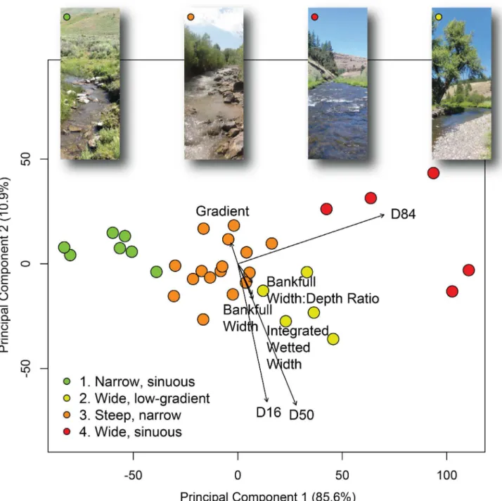
We classified the 33 CHaMP sites in the Middle Fork John Day Basin by clustering reaches on multiple instream geomorphic attributes: bankfull width, wetted width, site sinuosity, stream gradient, bankfull width to depth ratio, andD16,D50, andD84particle size. CHaMP
consistency with data used in the classifications presented in Sections 2.3, 2.4, and 2.5. We selected a partitioning around medoids clustering algorithm in R (‘cluster’package; [84,85]), a divisive clustering technique, to identify groups of distinct reach types based on the Euclidean distance between reaches’instream geomorphic attributes. We validated differences in stream attributes between reach clusters using PERMANOVA [86]. We plotted the cluster solution within a principal components analysis (PCA) of the same stream channel attributes, visually comparing CHaMP reaches classified under each method (RSF, NCC, RCS, clustering). Full statistical methods and results are presented in the supporting information (Text A inS1 File).
The statistical classification applied here is purely form-based, incorporating geomorphic process only by grouping channels on their physical attributes’similarity (Table 2). Field-derived measurements of channel gradient, bankfull channel dimensions, and bed material size were used to describe channel form, which, in aggregate, reflect the ability of a given stream reach to transport supplied sediment, similar to how RCS estimates process using form-based attributes (Section 2.5). An important distinction between the statistical classification and the other three classifications used here is how they incorporate valley setting. While RSF, NCC, and RCS estimate sediment supply and delivery processes by classifying valley setting (albeit at a later stage in RCS), the statistical clustering employed here does not use valley confinement or surrogates (stream order, valley slope) as a discriminator in its classification.
Statistical clustering approaches are relatively rare in geomorphic channel classification compared to the other three frameworks described here. Despite the need for further explora-tion of this technique, the purpose of this research was not to explore the effect of various sta-tistical classification algorithms (e.g. agglomerative versus divisive clustering, different distance measures, etc.), but to select a parsimonious framework that aggregates channels into user-defined sets of groups based on channel metrics. Future comparisons of stream channels should build on this example by comparing multiple statistical classification methodologies in geomorphic classifications.
Assessing classification framework agreement
To compare agreement between classification frameworks at the 33 CHaMP sites discussed in Section 2.2, we compared classification outputs by using both (a) expert judgment and (b) a multivariate comparison of reaches based on their resulting outputs in each of the four frameworks.
To compare the frameworks’outputs using an expert judgment approach, we began by using the eight reach types identified by Natural Channel Classification, as these classes pro-vided intuitive and straightforward descriptors of channel planform [25]. For each NCC reach type, we identified the most closely related reach types from the RSF, the RCS (using top-level channel types A-G), and statistical clustering. Where available (RSF, RCS), decision trees were used to select those reach types that best approximated each NCC type based on common geo-morphic metrics (gradient, geogeo-morphic units present, planform). In the case of statistical clus-tering, the geomorphic attributes inherent to each of the four clusters (Fig 2) were used to approximate the corresponding NCC reach type.
we attempted to take an inclusive approach when determining agreement among reach types between frameworks, as considerable geomorphic variability can exist across each reach type within a given framework [6,27].
In addition to our expert judgment-based, qualitative comparison of framework outputs, we also quantitatively assessed reaches’classification output agreement using a multivariate
Fig 2. Statistical clustering of reaches using principal components analysis (PCA) based on gradient,D16,D50,D84, bankfull width, bankfull width: depth ratio, and integrated wetted width (i.e. channel width at time of sampling), classified into four discrete groups using partitioning around medoids.Vectors of stream channel variables are plotted based on the strength of their correlation to the PCA (e.g. longer vectors are more strongly correlated to the channel form variable PCA). The first and second principal components explained 85.6% and 10.9% of the variability in the reach attribute data within the PCA. Point colors represent which cluster each reach was classified into, and representative photographs provide examples of characteristic reach morphology for each cluster.
approach. We created a table of each reach’s classification outputs, calculated a Gower’s dis-similarity matrix between each reach, and then visualized reaches in a cluster analysis and ordi-nation. Gower’s distance scales nominal variables between 0 and 1, allowing us to calculate the similarity of discrete reaches’agreement using the categorical outputs from each framework. We clustered reaches based on their output dissimilarity using an average linkage clustering algorithm. We then conducted a two-dimensional principal coordinates analysis (PCoA) on the same Gower’s dissimilarity matrix of classification outputs, and used this to visualize simi-larity between classifications at each reach. It is important to note that while the qualitative, expert judgment-based approach above uses NCC as the top-level discriminator in assessing framework agreement, the statistical assessment described here is a multivariate comparison of outputs between all four frameworks.
Results
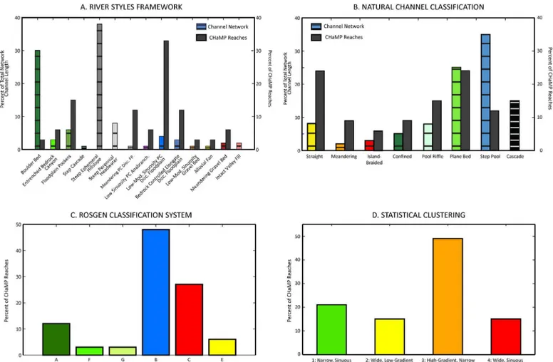
The River Styles framework
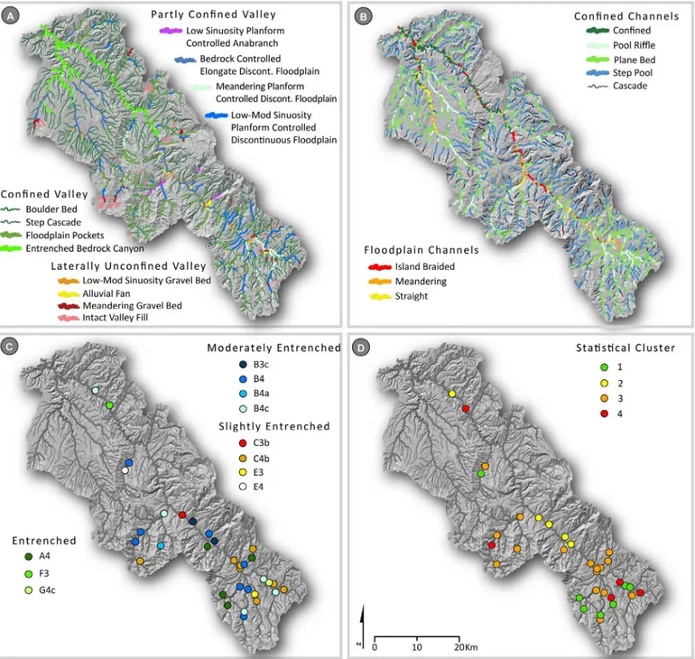
In total, 14 distinct river styles were classified across the MFJD Watershed. To begin, landscape units were classified across the watershed (Fig A inS1 File). The river styles trees showing the characteristics of each river style are shown in Figs B–D inS1 File, and the distribution of river styles within the MFJD Watershed is shown inFig 3A, with distinctions made based on valley confinement (confined, partly confined, laterally unconfined; [34]). Overall, confined valley channels were the most common river styles across the MFJD Watershed (86% of total stream
Table 3. Analogous reach types between NCC, RSF, RCS, and statistical clustering based on common geomorphic attributes.Those reach types with good (G) or moderate (M) agreement are included, while those with poor agreement are not shown here, but are noted inTable 4.
NCC reach type
RSF reach type RCS reach type Statistical cluster
Island Braided
Low Sinuosity Planform Controlled Anabranching (G); Intact Valley Fill (M); Alluvial Fan (M)
D (G) 2: Wide, Sinuous (M)
Meandering Meandering Gravel Bed (G); Meandering Planform-Controlled
Discontinuous Floodplain (G); Low-Moderate Sinuosity Gravel Bed (M); Low-Moderate Sinuosity Planform-Controlled Disc. Floodplain (M); Bedrock-Controlled Elongate Discontinuous Floodplain (M); Low-Moderate Sinuosity Gravel Bed (M)
C (G), E (G), G (M), F (M)
4: Wide, Sinuous (G); 1: Narrow, Sinuous (M); 2: Wide, Low-Gradient (M)
Straight Boulder Bed (G); Meandering Planform-Controlled Disc. Floodplain (G); Confined Valley—Floodplain Pockets (G); Low-Moderate Sinuosity Partly Confined Disc. Floodplain (G); Low-Moderate Sinuosity Gravel Bed (G); Alluvial Fan (M); Bedrock-Controlled Elongate Discontinuous Floodplain (M)
A (G); B (G); G (M)
2: Wide, Low-Gradient (G); 3: Steep, Narrow (G)
Confined Entrenched Bedrock Canyon (G); Confined Valley—Floodplain Pockets (G); Step Cascade (G); Steep Perennial Headwater (M); Steep Ephemeral Hillslope (M)
A (G); F (G); G (G); B (M)
1: Narrow, Sinuous (G); 3: Steep, Narrow (G); 2: Wide, Low Gradient (M)
Cascade Step Cascade (G); Boulder Bed (G); Floodplain Pockets (M); Steep Perennial Headwater (M); Steep Ephemeral Hillslope (M)
B (G); F (G); G (G); A (M)
3: Steep, Narrow (G) 1: Narrow, Sinuous (M)
Pool Riffle Meandering Gravel Bed (G); Meandering Planform Controlled
Discontinuous Floodplain (G); Confined Valley—Floodplain Pockets (G); Bedrock-Controlled Elongate Discontinuous Floodplain (G); Low-Moderate Sinuosity Planform Controlled Disc. Floodplain (M); Meandering Partly-Confined Floodplain (M)
C (G); F (G); G (G); E (G); B (M)
1: Narrow, Sinuous (G); 2: Wide, Low Gradient (G); 4: Wide, Sinuous (M)
Step Pool Boulder Bed (G); Step Cascade (G); Steep Perennial Headwater (G); Steep Ephemeral Hillslope (G); Confined Valley—Floodplain Pockets (M)
B (G); F (G); G (G); A (M)
3: Steep, Narrow (G); 1: Narrow, Sinuous (M)
Plane Bed Entrenched Bedrock Canyon (G); Confined Valley—Floodplain Pockets (G); Bedrock Controlled Elongate Discontinuous Floodplain (G); Low-Moderate Sinuosity Planform Controlled Disc. Floodplain (G); Meandering Planform Controlled Floodplain (M); Boulder Bed (M); Steep Perennial Headwater (M); Steep Ephemeral Hillslope (M)
A (G); B (G); C (G); F (G); G (G)
3: Steep, Narrow (G); 1: Narrow, Sinuous (M); 4: Wide, Sinuous (M)
length;Table 4), whereas channels in partly confined valleys (8%) and laterally unconfined val-leys (6%) were far less common (Fig 3A). Small, low-order, confined channels (boulder bed and steep ephemeral hillslope river styles) comprised the majority of total stream length within the watershed (68%,Table 4). Regarding the most common classifications of CHaMP sites, 33% of sites were classified as partly confined valley with low-moderate sinuosity
planform-Fig 3. Results of the four classifications.(A) River Styles, (B) Natural Channel Classes, (C) Rosgen Classification System, and (D) statistical classification with clustering (partitioning around medoids) mapped across the Middle Fork John Day Basin. River Styles and Natural Channel Classes are mapped across the entire stream network, while Rosgen Classification System and statistical classification results are presented only for CHaMP reaches. Full River Style and Natural Channel Class results for CHaMP reaches are presented inTable 4.
Table 4. Classification results for the four methods compared here.
Classification framework
Confinement Reach type Total stream
length (km)
% Total length
# CHaMP reaches
% CHaMP reaches
RSF Confined Boulder bed 1230.7 30.2 1 3.0
RSF Confined Entrenched bedrock canyon 121.1 3.0 2 6.1
RSF Confined Occasionalfloodplain pockets 242.5 6.0 5 15.2
RSF Confined Step cascade 37.9 0.9 0 0
RSF Confined Steep ephemeral hillslope 1542.3 37.9 0 0
RSF Confined Steep perennial headwater 319.4 7.8 0 0
RSF Partly confined Meandering planform controlled discontinuousfloodplain
34.5 0.8 4 12.1
RSF Partly confined Low sinuosity planform controlled anabranching
18.2 0.5 2 6.1
RSF Partly confined Low-moderate sinuosity planform-controlled discontinuousfloodplain
170.2 4.2 11 33.3
RSF Partly confined Bedrock controlled elongate discontinuousfloodplain
113.8 2.8 4 12.1
RSF Laterally
unconfined
Low-moderate sinuosity gravel bed 31.9 0.8 1 3.0
RSF Laterally
unconfined
Alluvial fan 49.3 1.2 1 3.0
RSF Laterally
unconfined
Meandering gravel bed 62.9 1.5 2 6.1
RSF Laterally
unconfined
Intact valleyfill 99.4 2.4 0 0
NCC Bankfull width>8 m
Straight 132.9 7.8 8 24.2
NCC Bankfull width>8 m
Meandering 34.7 2.0 3 9.1
NCC Bankfull width>8 m
Island-braided 42.8 2.5 2 6.1
NCC Bankfull width>8 m
Confined 76.5 4.5 3 9.1
NCC Bankfull width<8 m
Pool riffle 129.9 7.7 5 15.2
NCC Bankfull width<8 m
Plane bed 431.5 25.4 8 24.2
NCC Bankfull width<8 m
Step pool 595.3 35.1 4 12.1
NCC Bankfull width<8 m
Cascade 253.7 14.9 0 0
RCS Entrenched A4 4 12.1
RCS Entrenched F3 1 3.0
RCS Entrenched G4c 1 3.0
RCS Moderately
entrenched
B3c 2 6.1
RCS Moderately
entrenched
B4 8 24.2
RCS Moderately
entrenched
B4a 1 3.0
RCS Moderately
entrenched
B4c 5 15.2
RCS Slightly
Entrenched
C3b 1 3.0
controlled discontinuous floodplain reach types, 15% were classified as confined valley with occasional floodplain pockets, and 12% each were classified as partly confined valley with meandering planform-controlled discontinuous floodplain and bedrock-controlled elongate discontinuous floodplain reach types (Fig 3A;Table 4).
Natural channel classification
Natural Channel Classification derived nine channel patterns across the Columbia River Basin [25], eight of which were predicted within the MFJD Watershed (Figs3Band4B). By total stream length, the majority of reaches (83%) were small channels with bankfull width<8 m
(Table 4). Across the MFJD, 35% of the total reach length was classified as step-pool channels, and 25% classified as plane-bed channels [20]. For channels>8 m bankfull width, 8% of the
total reach length was classified as having a straight planform, 3% of channels classified as island-braided, and 2% classified as meandering (Fig 3B;Table 4). The remaining reaches>8
m were classified as confined channels because valley width was less than four times bankfull channel width [25]. With regard to the most common classifications of CHaMP sites, 25% of sites each were classified as straight or plane bed reaches, with an additional 15% of sites classi-fied as pool riffle (Fig 3B;Table 4).
Rosgen classification system
We classified 11 RCS stream types within 33 CHaMP reaches in the MFJD Watershed (Fig 3C;
Table 4). The most common stream types, each containing 24% of the CHaMP reaches, were B4 (stable plane bed with occasional pools) and C4b (low gradient, meandering, riffle/pool sequences;Fig 4C). In total, 50% of the reaches were B stream types, all of which were within valley type II (colluvial, moderately steep and confined), with a single exception. C stream types (sinuous, wide and low-gradient) were the next most common (27%) and E (highly sinu-ous, coarse-fine bed), F (entrenched, wide, moderately sinusinu-ous, low gradient), and G
(entrenched, low-gradient, low width:depth ratio) types were the least common (3% each). Only one CHaMP site had a substantial length of side channels (24%), however the other met-rics did not fit a D stream type. Therefore, we did not delineate any multi-threaded channels (RCS stream type D).
Table 4. (Continued)
Classification framework
Confinement Reach type Total stream
length (km)
% Total length
# CHaMP reaches
% CHaMP reaches
RCS Slightly
Entrenched
C4b 8 24.2
RCS Slightly
Entrenched
E3 1 3.0
RCS Slightly
Entrenched
E4 1 3.0
Clustering Narrow, sinuous (1) 7 21.2
Clustering Wide, low-gradient (2) 5 15.2
Clustering High-gradient, narrow (3) 16 48.5
Clustering Wide, sinuous (4) 5 15.2
River Styles and Columbia Basin Natural Channel Classification are summarized across the entire network and at CHaMP sites, while the Rosgen Classification System and clustering classifications are summarized only for reaches with CHaMP channel data.
Statistical classification
Because statistical clustering does not test for ana prioriset of outcomes as other statistical approaches might, we compared multiple clustering results (two to ten clusters of channels) from clusters generated using a partitioning around medoids algorithm. We selected a four cluster final solution based on cluster fidelity; that is, the statistical and geomorphic differences in the multiple attributes used to distinguish between groups, minimizing overlap between cluster groups (Fig 2; Tables A–C inS1 File). We did this objectively rather than trying to create ana priorinumber of reach types to match the other frameworks’number of outputs. After plotting the final cluster solution within a principal component analysis (PCA), the clustered stream channel attributes showed that each group differed based on multiple channel form attributes. The PCA indicated that the four identified clusters were meaningful representations of the sampled reaches and not just statistical artifacts. Each cluster was named based on the dominant attributes that differentiated clusters from one another. The four final groups con-sisted of (1) narrow, sinuous, high-gradient reaches (n = 7), (2) wide, low-gradient, coarse sub-strate reaches with high width to depth ratios (n = 5), (3) high-gradient, narrow reaches with moderate-sized substrates (n = 16), and (4) moderate gradient, wide and sinuous, coarse-sub-strate reaches (n = 5;Fig 2;Table 4). The number of CHaMP sites assigned to each cluster are
Fig 4. Classification results across network and sites.Percent of total network channel length and percent of CHaMP sites classified into reach types using each classification framework (A-D).
shown inFig 4D. Channel clusters were significantly different from one another (PERMA-NOVA;p<0.05), and particleD16,D50,andD84were the attributes that were most strongly
correlated to the principal component analysis (Tables A–C inS1 File). Clusters in the final four-cluster solution were distinct (silhouette widths 0.24–0.60; mean width 0.41;Fig 2). The cluster group assigned to each CHaMP site is shown inFig 3Dand Fig G inS1 File.
Comparison of framework agreement
The analysis of agreement between reach types of each framework (Section 2.8;Table 5) gener-ally indicates that far more often than not, frameworks produced reach type classifications that were congruent with one another. Clustering of the classification outputs at each reach showed that seven reaches had perfect agreement with at least one other reach; that is, each of the four classification outputs were identical across the four classifications (Table 5;Fig 5; distance of 0 in Figs6and7). Seven reaches’outputs agreed for three of the four outputs (distance of 0.2 in
Fig 6). A majority of the reaches agreed on two of the four classification outputs (Table 5; Figs
6and7). Very few reaches classified as a combination of vastly different classification outputs than the other streams (Fig 6). These trends were apparent in the PCoA ordination of reaches based on their classification outputs (Fig 7). Similarly, when using expert judgment to compare the level of agreement between NCC and each of the other three frameworks at 33 CHaMP sites (for a total of 99 comparisons;Table 5), we found“good”agreement at 60 sites (61%),
“moderate”agreement at 19 sites (19%), and“poor”agreement at 20 sites (Table 5). Thus, rea-sonable agreement (good or moderate) was found at 80% of sites.
There were consistent relationships between site morphology and the level of classification agreement (good, moderate, or poor). In the qualitative analysis of classification agreement (Table 5), individual reaches classified into groups of similar morphologies within one work sometimes failed to align with a comparable group under another classification frame-work. This pattern was most apparent in confined reach types that did not aggregate into consistent groups across statistical clusters, Rosgen Classification System types, and natural channel classes. For example, River Styles’confined valley with occasional floodplain pockets were classified as all four statistical clusters, five different RCS reaches, and three NCC classes (Table 5;Fig 7). In contrast, partly confined channel types were more likely to be grouped into only one or two channel types from other classifications. For example, River Styles’partly con-fined low-moderate sinuosity, planform-controlled discontinuous floodplain grouped into RCS types of C4b and B4, and NCC classes of plane bed or straight planform, and steep/narrow and narrow/sinuous statistical clustering classes.
Additionally, the partly confined low-sinuosity planform-controlled anabranching river style occurred exclusively as B4 RCS classes, straight, narrow statistical cluster, and straight NCC. The partly confined bedrock-controlled elongate discontinuous floodplain river style classified as slightly to moderately entrenched, moderate sinuosity RCS types (C, B channels), and wide, low-gradient clusters, but was less consistently grouped by NCC (straight, confined, and island braided). While strict fidelity between groups within each classification did not occur, partly confined River Styles grouped well with the other classifications based on their component inputs.
Discussion
Comparison of classification outputs: example sites
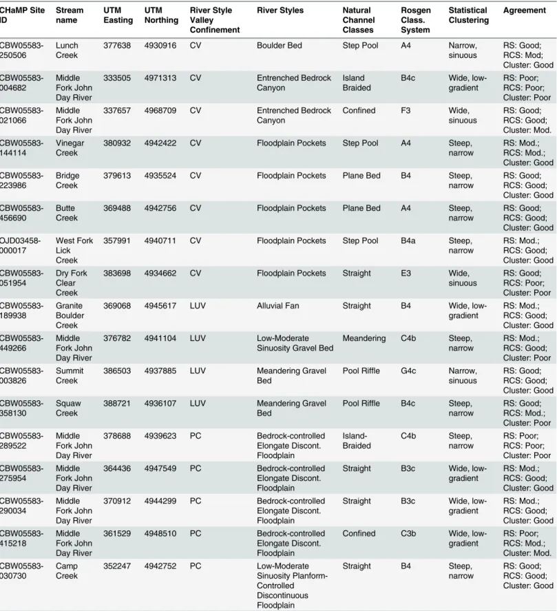
Table 5. Classification results and agreement for each CHaMP site across the four classification frameworks. CHaMP Site ID Stream name UTM Easting UTM Northing River Style Valley Confinement
River Styles Natural Channel Classes Rosgen Class. System Statistical Clustering Agreement CBW05583-250506 Lunch Creek
377638 4930916 CV Boulder Bed Step Pool A4 Narrow,
sinuous RS: Good; RCS: Mod; Cluster: Good CBW05583-004682 Middle Fork John Day River
333505 4971313 CV Entrenched Bedrock Canyon
Island Braided
B4c Wide, low-gradient RS: Poor; RCS: Poor; Cluster: Poor CBW05583-021066 Middle Fork John Day River
337657 4968709 CV Entrenched Bedrock Canyon
Confined F3 Wide,
sinuous RS: Good; RCS: Good; Cluster: Mod. CBW05583-144114 Vinegar Creek
380932 4942422 CV Floodplain Pockets Step Pool A4 Steep,
narrow RS: Mod.; RCS: Mod.; Cluster: Good CBW05583-223986 Bridge Creek
379613 4935524 CV Floodplain Pockets Plane Bed B4 Steep,
narrow RS: Good; RCS: Good; Cluster: Good CBW05583-456690 Butte Creek
369488 4942756 CV Floodplain Pockets Plane Bed A4 Steep,
narrow RS: Good; RCS: Good; Cluster: Good OJD03458-000017 West Fork Lick Creek
357991 4940711 CV Floodplain Pockets Step Pool B4a Steep,
narrow RS: Mod.; RCS: Good; Cluster: Good CBW05583-051954 Dry Fork Clear Creek
383698 4934662 CV Floodplain Pockets Straight E3 Wide,
sinuous RS: Good; RCS: Poor; Cluster: Poor CBW05583-189938 Granite Boulder Creek
369068 4945617 LUV Alluvial Fan Straight B4 Wide,
low-gradient RS: Mod.; RCS: Good; Cluster: Good CBW05583-449266 Middle Fork John Day River
376782 4941104 LUV Low-Moderate
Sinuosity Gravel Bed
Meandering C4b Steep, narrow RS: Mod.; RCS: Good; Cluster: Poor CBW05583-003826 Summit Creek
386503 4937885 LUV Meandering Gravel Bed
Pool Riffle G4c Narrow, sinuous RS: Good; RCS: Good; Cluster: Good CBW05583-358130 Squaw Creek
388721 4936107 LUV Meandering Gravel Bed
Pool Riffle B4c Steep, narrow RS: Good; RCS: Mod.; Cluster: Poor CBW05583-289522 Middle Fork John Day River
378688 4939623 PC Bedrock-controlled Elongate Discont. Floodplain Island-Braided C4b Steep, narrow RS: Poor; RCS: Poor; Cluster: Poor CBW05583-275954 Middle Fork John Day River
364436 4947549 PC Bedrock-controlled Elongate Discont. Floodplain
Straight B3c Wide, low-gradient RS: Mod.; RCS: Good; Cluster: Good CBW05583-290034 Middle Fork John Day River
370912 4944299 PC Bedrock-controlled Elongate Discont. Floodplain
Straight B3c Wide, low-gradient RS: Mod.; RCS: Good; Cluster: Good CBW05583-415218 Middle Fork John Day River
361529 4948510 PC Bedrock-controlled Elongate Discont. Floodplain
Confined C3b Wide, low-gradient RS: Poor; RCS: Mod.; Cluster: Mod. CBW05583-030730 Camp Creek
352247 4942752 PC Low-Moderate
Sinuosity Planform-Controlled Discontinuous Floodplain
Straight B4 Steep,
narrow
RS: Good; RCS: Good; Cluster: Good
Table 5. (Continued) CHaMP Site ID Stream name UTM Easting UTM Northing River Style Valley Confinement
River Styles Natural Channel Classes Rosgen Class. System Statistical Clustering Agreement CBW05583-330226 Camp Creek
357015 4947826 PC Low-Moderate
Sinuosity Planform-Controlled Discontinuous Floodplain
Straight B4c Steep,
narrow RS: Good; RCS: Good; Cluster: Good CBW05583-118770 North Fork Bridge Creek
375925 4933066 PC Low-Moderate
Sinuosity Planform-Controlled Discontinuous Floodplain
Step Pool A4 Narrow,
sinuous RS: Poor; RCS: Mod.; Cluster: Mod. CBW05583-299658 Clear Creek
382042 4930368 PC Low-Moderate
Sinuosity Planform-Controlled Discontinuous Floodplain
Plane Bed B4c Narrow, sinuous RS: Good; RCS: Good; Cluster: Mod. CBW05583-438922 Dry Fork Clear Creek
384597 4933274 PC Low-Moderate
Sinuosity Planform-Controlled Discontinuous Floodplain
Straight C4b Narrow,
sinuous RS: Poor; RCS: Poor; Cluster: Poor CBW05583-234122 Clear Creek
382238 4929332 PC Low-Moderate
Sinuosity Planform-Controlled Discontinuous Floodplain
Plane Bed B4 Steep,
narrow RS: Good; RCS: Good; Cluster: Good CBW05583-381682 Vinegar Creek
380718 4944390 PC Low-Moderate
Sinuosity Planform-Controlled Discontinuous Floodplain
Plane Bed C4b Steep,
narrow RS: Good; RCS: Good; Cluster: Good CBW05583-383986 Camp Creek
353774 4936398 PC Low-Moderate
Sinuosity Planform-Controlled Discontinuous Floodplain
Plane Bed C4b Steep,
narrow RS: Good; RCS: Good; Cluster: Good CBW05583-404210 Vinegar Creek
379442 4940614 PC Low-Moderate
Sinuosity Planform-Controlled Discontinuous Floodplain
Plane Bed B4 Steep,
narrow RS: Good; RCS: Good; Cluster: Good CBW05583-477938 Clear Creek
381713 4935379 PC Low-Moderate
Sinuosity Planform-Controlled Discontinuous Floodplain
Straight B4 Steep,
narrow RS: Poor; RCS: Good; Cluster: Good OJD03458-000536 Vinegar Creek
378654 4940187 PC Low-Moderate
Sinuosity Planform-Controlled Discontinuous Floodplain
Plane Bed C4b Steep,
narrow RS: Good; RCS: Good; Cluster: Good CBW05583-325362 Summit Creek
390544 4937077 PC Low-Moderate
Sinuosity Planform-Controlled Discontinuous Floodplain
Pool Riffle C4b Wide, sinuous
RS: Mod.; RCS: Good; Cluster: Good
(CHaMP site: CBW05583-004682), we found a B4c RCS type, wide, low-gradient statistical cluster, island-braided NCC, and entrenched bedrock canyon river style (Figs5and6). Readers are referred to the supporting information (Fig F inS1 File) for the characteristics of each RCS channel type. The statistical classification matched the definition of a wide, low-gradient, B4c RCS channel type. While it is plausible that a B4c RCS channel type and an entrenched bedrock canyon river style could be applied to the same reach, the island-braided NCC classification is deserving of further exploration as it may hint at a departure from historic channel condition, which NCC attempts to predict. Subsequent field visits to this site byO’Brien[Personal Com-munication] note the presence of numerous legacy sediment deposits (e.g. [87]) above the active channel, within a wide valley bottom that allows for channel adjustment. These observa-tions may imply that the system was overwhelmed by sediment during the early Holocene. Accordingly, the pre-disturbance classification of an island-braided channel using NCC may be appropriate in this case, and could hint at the background morphology of the channel.
In contrast, we found good agreement between all classification frameworks at two of the four example reaches (Fig 5) and seven total reaches (Figs6and7). The first is a laterally unconfined reach on the Middle Fork John Day River (Fig 5; CHaMP site: CBW05583-003826) classified as a G4c RCS type, narrow sinuous statistical cluster, pool-riffle NCC, and meander-ing gravel bed river style. The second site is a partly confined reach on Slide Creek (Fig 5; CHaMP site: CWB05583-144394), classified as a meandering planform-controlled discontinu-ous floodplain river style. This site was further classified as an E4 RCS reach, pool riffle RCC type, and narrow, sinuous statistical cluster. At these locations, the combination of geomorphic characteristics produced a reach classification that was highly similar in terms of valley setting, planform, and assemblage of geomorphic units between all four frameworks. In the case of the former site, the reach occurs within a broader ~10 km segment of the Middle Fork John Day that exhibits a sinuous planform in an unconfined valley. The latter site also occurs in a ~5 km
Table 5. (Continued)
CHaMP Site ID Stream name UTM Easting UTM Northing River Style Valley Confinement
River Styles Natural Channel Classes Rosgen Class. System Statistical Clustering Agreement OJD03458-000031 Camp Creek
351579 4940332 PC Low-Moderate
Sinuosity Planform-Controlled Discontinuous Floodplain
Confined B4 Wide,
sinuous RS: Poor; RCS: Mod.; Cluster: Poor CBW05583-144394 Slide Creek
344959 4955342 PC Meandering
Planform-Controlled Discontinuous Floodplain
Pool Riffle E4 Narrow, sinuous RS: Good; RCS: Good; Cluster: Good CBW05583-429810 Summit Creek
387760 4937802 PC Meandering
Planform-Controlled Discontinuous Floodplain
Meandering C4b Narrow, sinuous RS: Good; RCS: Good; Cluster: Mod. CBW05583-013322 Slide Creek
345607 4957140 PC Meandering
Planform-Controlled Discontinuous Floodplain
Pool Riffle B4 Steep, narrow RS: Good; RCS: Mod.; Cluster: Poor CBW05583-298738 Middle Fork John Day River
385006 4938373 PC Meandering
Planform-Controlled Discontinuous Floodplain
Meandering B4c Wide,
sinuous
RS: Good; RCS: Poor; Cluster: Good
segment of Slide Creek that exhibits a consistent meandering planform. These more longitudi-nally-continuous reaches are undoubtedly helpful for agreement in classification among con-tinuous frameworks (e.g. RSF and NCC) that may use disparate spatial scales of data (e.g. NHD+ and field-based validation versus NHD and basin-scale 10 m DEMs, respectively) and derive classifications remotely prior to field-based verification.
Fig 5. Illustrative example reaches describing agreement between classification outputs.Reaches at which the four classifications had poor agreement, moderate agreement, and good agreement in the observed channel planform.
Fig 6. Dendrogram of clustered reaches based on their classification outputs from each of the four frameworks.Reaches with a distance of zero that occur on adjacent nodes of the same length are identical. For example, reaches CBW05583-381682 and CBW05583-383986 are identical in how they were classified by all four frameworks. Reaches were clustered using an average linkage clustering algorithm and Gower’s distance matrix.
An example of a site with moderate agreement was found in a partly-confined valley setting on Slide Creek (Figs5and6; CHaMP Site CBW05583-013322). This reach showed different, but plausible combinations of channel types. The reach was classified as a partly-confined val-ley with meandering planform-controlled discontinuous floodplain river style—whose in-channel geomorphic unit assemblage is essentially repeating pool-riffle sequences—and pool-riffle in NCC, but was classified as a B4 RCS and steep, narrow statistical cluster. Reaches like this that exhibit mixed agreement between classification frameworks highlight that subtle dif-ferences in channel form, such as channel gradient and sinuosity, can lead to significant differ-ences in the classification of an individual reach. These differdiffer-ences arise as a result of the hierarchical and statistical clustering classifications used here, as the order of appearance of
Fig 7. Principal coordinates analysis ordination showing reaches’relative similarity based on the outputs of the four classification frameworks. Each reach is plotted within each classification output for ease of interpretation. Reaches were grouped within the ordination space using Gower’s distance. Reaches that are more similar to one another are closer together in the ordination space. R2values correspond to the fit of a given classification framework’s
outputs to the ordination of all classification outputs.
geomorphic metrics in a decision tree can vary between frameworks and subsequently affect classification output.
Why do classification frameworks differ?
Differences in classification frameworks’outputs ultimately arise because each framework emphasizes physical variables differently throughout the classification process. Although the data requirements between classification frameworks are similar, including channel planform metrics, substrate, and the ability of a channel to migrate and access sediment sources (Table 2), the order in which these attributes appear within a particular framework’s decision tree may vary markedly (see Figs B–F inS1 File). For example, at the broad planform scale, the first step in the differentiation of reach types within the RCS is to distinguish between single-and multi-thread channels. In contrast, this characterization of channel planform is completed several steps later in the River Styles framework, which instead places the greatest importance on the degree of valley confinement. Both RCS and River Styles, however, make their final dif-ferentiation between stream types based on the bed material texture within a reach.
When considering statistical approaches such as NCC and statistical clustering, all physical attributes are used in the grouping algorithm, and hierarchical decision trees are foregone. Because most statistical classification techniques computationally determine which of the input variables are most important in differentiating stream types, ranking them accordingly,a prioriimportance is not placed upon a given variable. While variables can be weighted in clus-tering and machine-learning algorithms to emphasize the importance of specific processes, many classifications, like NCC’s support vector machine, instead use training data to fit algo-rithms before computing classes for a data set. This approach is limited not by what variable is perceived to be most important, but rather, by what training data are available from which to build a model.
Similar constraints exist on the clustering method used here, which can only group reaches for which data are available. In building representative statistical classifications, having spa-tially-balanced, randomized sampling is ideal [88]. Another key methodological consideration in using statistical classification approaches is that the number of classes is often determined by the strength of the fit between data and algorithm, and must be validated by expert judgment of the classified statistical groups and their geomorphic likelihood. Robust clustering was observed here with a relatively small number of classes (four), whereas the other three classifi-cation schemes had between eight and fourteen classes. Accordingly, parameter and cluster algorithm selection, data transformation or standardization can all influence how well data fits a given clustering algorithm, with consequences for whether geomorphically meaningful groups correspond to statistically grouped data.
More generally, the difference in the relative importance of each physical variable within a particular classification framework points to the form-process interactions that each classifica-tion method attempts to document or explain. Particularly in the hierarchical approaches (e.g. RSF, RCS), the order of appearance of variables in the classification has a large impact on the classification of an individual channel reach. Distinct differences are also evident when the original intent of the classification framework is considered. Some frameworks produce analy-ses of current reach type (e.g. RSF, RCS, statistical clustering), while others predict pre-distur-bance or natural channel morphology (e.g. NCC). Differences in the temporal output of each framework may not be intuitive, but provide a critical context for interpreting and using the outputs derived [88].
straight streams. Conversely, in wide valleys, we expect to find relatively wide, freely meander-ing streams that occupy large portions of the valley bottom [6]. In locations where this is not the case, we note that channel classification frameworks exhibited strong disagreement in their output (Table 5;Fig 7). For example, the frameworks disagreed in relatively wide valleys where channels occupied a small area of the valley floor (sites 004682, CBW05583-289522, and CBW05583-415218) or exhibited unusually low sinuosity despite flowing through a wide valley. In contrast, some channels exhibited moderate sinuosity despite flowing in very narrow valleys (e.g. site CBW05583-051954;Table 5). A number of factors can lead to these scenarios, including anthropogenic straightening of channels to reduce bank erosion or lateral migration [89,90], livestock grazing [91], or in the case of sinuous channels in narrow valleys, the presence of jams or dams associated with large woody debris accumulation and beaver activity, respectively [65,92]. The frameworks used here incorporate valley setting to draw inference on channel sinuosity, slope, and ultimately, the form of the channel. Particularly in NCC and RSF, valley setting is a top-level discriminator of channel classification (Figs B–E in
S1 File). Components of RCS similarly leverage valley setting to infer the stream types found there [26,27]. Thus, we caution that despite the overall agreement between frameworks that we observed, classification outputs may differ markedly in locations where geomorphic, biotic, or anthropogenic factors cause channels to diverge from expected forms given a particular valley setting. We note that further research is needed to assess classification agreement in areas where valley setting may not be a reliable predictor of channel form (e.g., ephemeral channels, channels at the meandering/braided transition, and in heavily disturbed watersheds).
Form and process in channel classification
Our comparison of four distinct classification frameworks demonstrates that there is signifi-cant overlap and agreement between outputs of the classifications used here. The most com-mon result in all four frameworks was some variant of moderately-high gradient channel, in a partly-confined valley setting, with coarse gravel substrate, reflecting the high relief nature of the Middle Fork John Day Basin resulting from resistant igneous and metamorphic lithologies (Fig 3). Similarly, the least common channel types in all four frameworks were those variants corresponding to wide, freely meandering, low-gradient streams. These laterally unconfined streams are the ones most emphasized in classic channel planform classification and the fluvial geomorphology literature [93], although they are rare in many montane regions [34].
The four classification frameworks showed widespread agreement between their outputs despite being variably based in either form or process (Table 2). While all four frameworks contained metrics that either directly described the processes at work in channel reaches or employed measurements of channel form as surrogates for geomorphic processes, the relative role of form- and process-based components varied between frameworks. For example, while the RSF depends on observation of processes (e.g. channel behavior at overbank flow, interac-tion with vegetainterac-tion), NCC and RCS rely on measurements of channel form that are directly related to sediment supply and transport competence at individual channel reaches. Taken to the extreme, the statistical clustering approach used here exclusively relies on field-based mea-sures of channel form in an attempt to differentiate individual reaches. Despite the range of form- and process-based metrics in each framework, the four approaches exhibited overall agreement, suggesting that a simple differentiation in terms of form or process does not charac-terize the utility of a particular approach.
aspects of form and process to group river reaches. In general, the use of channel form metrics as surrogates for stream or valley-scale processes is widespread [3]. This is perhaps a reflection of the complexity involved in a purely process-based classification framework, which would require high-resolution measurement of rates of sediment transport, supply, and channel adjustment at many sites throughout a stream network [4]. Such approaches are only possible under exceptional mandates that require a great deal of human and financial capital (e.g. [94]). In most basins, classification frameworks based on channel form metrics are practical surro-gates for inferring process.
Similarly, rapid geomorphic assessment (RGA) methods that nominally characterize pro-cess domains along streams often rely on form-based measurements or observations (e.g. degree of bank erosion or channel incision) to infer processes related to channel stability [10]. We acknowledge that the degree to which cutoffs and thresholds between channel types, partic-ularly in hierarchical classification schemes (e.g. RSF, NCC, RCS), reflect true transitions in process domains likely requires further investigation. At the same time, form-based assess-ments have been borne of a necessity to characterize river reaches over large spatial scales within a reasonable timeframe and at moderate costs, leading to their widespread application in the geomorphic, land management, and hydrologic communities.
While classifications represent“snapshots”of reaches, rivers are dynamic and adjust in response to water and sediment supply [95,96]. If these boundary conditions are not consid-ered, assumptions of stability may be made when channel form may actually indicate a tran-sient, or responding state, given altered sediment or water availability. For this reason, some classification frameworks separate current character and behavior from past evolution, condi-tion and trajectory (e.g. the RSF), and others separate condicondi-tion (e.g. RCS). In other systems, the degree of channel departure from background conditions is considered and may completely invalidate certain frameworks. For example, in watersheds heavily influenced by mill dams or beaver ponds and their associated legacy sediment deposits [87,97], the NCC clas-sification approach may not provide an informative river clasclas-sification as this method predicts pre-disturbance channel planform.
There are instances where applying multiple classification frameworks may yield insight into channel processes or watershed disturbance history that individual frameworks may not reveal. For example, divergence between frameworks that classify current versus historic chan-nel form (e.g., RSF and NCC, respectively) may point to reaches that have undergone signifi-cant disturbance and planform alteration, and thus differ from expected background
characteristics. Alternatively, the comparison of watershed-scale frameworks with reach-based classifications (e.g., RSF versus RCS) may aid in pinpointing reaches that differ from the char-acteristic downstream progression of channel patterns within a basin, thus providing insight into local geologic/geomorphic controls or areas of intense disturbance that drive channel form.