www.hydrol-earth-syst-sci.net/20/5035/2016/ doi:10.5194/hess-20-5035-2016
© Author(s) 2016. CC Attribution 3.0 License.
iCRESTRIGRS: a coupled modeling system for cascading
flood–landslide disaster forecasting
Ke Zhang1,2,3, Xianwu Xue2, Yang Hong2,5, Jonathan J. Gourley4, Ning Lu6, Zhanming Wan2, Zhen Hong2, and Rick Wooten7
1Cooperative Institute for Mescoscale Meteorological Studies, University of Oklahoma, Norman, OK 73072, USA 2Hydrometeorology and Remote Sensing (HyDROS) Laboratory, School of Civil Engineering and Environmental Science,
and Advanced Radar Research Center, University of Oklahoma, Norman, OK 73072, USA
3State Key Laboratory of Hydrology-Water Resources and Hydraulic Engineering, Hohai University, Nanjiang,
Jiangsu, 210098, China
4NOAA/National Severe Storms Laboratory, Norman, OK 73072, USA 5Department of Hydraulic Engineering, Tsinghua University, Beijing, China
6Department of Civil & Environmental Engineering, Colorado School of Mines, Golden, CO 80401, USA
7North Carolina Geological Survey, North Carolina Department of Environmental Quality, Swannanoa, NC 28778, USA
Correspondence to:Ke Zhang ([email protected]) and Yang Hong ([email protected])
Received: 22 March 2016 – Published in Hydrol. Earth Syst. Sci. Discuss.: 19 April 2016 Revised: 30 September 2016 – Accepted: 23 November 2016 – Published: 20 December 2016
Abstract. Severe storm-triggered floods and landslides are two major natural hazards in the US, causing property losses of USD 6 billion and approximately 110–160 fatalities per year nationwide. Moreover, floods and landslides often oc-cur in a cascading manner, posing significant risk and lead-ing to losses that are significantly greater than the sum of the losses from the hazards when acting separately. It is pertinent to couple hydrological and geotechnical modeling processes to an integrated flood–landslide cascading disaster model-ing system for improved disaster preparedness and hazard management. In this study, we developed the iCRESTRIGRS model, a coupled flash flood and landslide initiation model-ing system, by integratmodel-ing the Coupled Routmodel-ing and Excess STorage (CREST) model with the physically based Transient Rainfall Infiltration and Grid-Based Regional Slope-Stability (TRIGRS) landslide model. The iCRESTRIGRS system is evaluated in four river basins in western North Carolina that experienced a large number of floods, landslides and debris flows triggered by heavy rainfall from Hurricane Ivan during 16–18 September 2004. The modeled hourly hydrographs at four USGS gauge stations show generally good agreement with the observations during the entire storm period. In terms of landslide prediction in this case study, the coupled model has a global accuracy of 98.9 % and a true positive rate of
56.4 %. More importantly, it shows an improved predictive capability for landslides relative to the stand-alone TRIGRS model. This study highlights the important physical connec-tion between rainfall, hydrological processes and slope sta-bility, and provides a useful prototype model system for op-erational forecasting of flood and landslide.
1 Introduction
the sum of the losses from the hazards if acting separately. One example is the intense precipitation in the Colorado Front Range on 11–12 September 2013 that triggered flash floods and at least 1138 debris flows, resulting in 8 fatal-ities and more than 20 000 buildings, 485 miles of roads and 50 bridges either damaged or destroyed (Coe et al., 2014). Another example of the devastating impacts of cas-cading multiple hazards: rain from the remnants of hurri-canes Frances and Ivan triggered 400 reported slope failures of various types in the Blue Ridge Mountains of North Car-olina, and at least 33 debris flows and major floods in Macon County, causing 5 deaths, destroying 16 homes, and damag-ing infrastructure (Wooten et al., 2008; Bauer et al., 2012). Such events make it critical to provide the public with risk-informed forecasting and warning systems in which multi-hazard threats are assessed and quantified.
According to a global natural disaster synthesis report (Dilley et al., 2005), over 790 million people are exposed to more than one natural hazard, based on the past 2 decades of historical loss data. Concurrent or time-lagged cascading multi-hazards are worldwide phenomena. In spite of their cascading nature, forecasts and warnings and risk assess-ments for such events conventionally are oriented towards single hazards, treating the cascading events as independent phenomena (Hsu et al., 2011; Wastl et al., 2011). One ex-ample is the severe storm system accompanied by a deadly tornado, heavy rain, and flash flooding that occurred in Ok-lahoma City (OKC) on 31 May 2013, in which more peo-ple were killed unexpectedly by the flash flooding than by the tornado, making it the deadliest flooding event that has ever occurred in OKC. This is partly due to the fact that the storm (accompanied by heavy precipitation and the tornado) and flash flood were forecasted by two separate warning sys-tems and their warnings were issued separately (Uccellini et al., 2014); the public was well aware of the tornado threat but largely unaware of the flood threat in spite of several National Weather Service (NWS) products and outreach ef-forts (Uccellini et al., 2014). Moreover, the public’s attention was mostly drawn to the tornado warnings (not to the flash flooding threat) mainly because this storm occurred only 10 days after the disastrous EF-5 tornado which devastated Moore, OK, and resulted in 24 fatalities and USD 2 billion in property damage. Although several recent studies have investigated multi-hazards and multi-hazard risk assessment (Budimir et al., 2014; Gill and Malamud, 2014; May, 2007; Mignan et al., 2014), these multi-hazard studies are still in the early stages of conceptual development (Gill and Mala-mud, 2014; Kappes et al., 2010). Knowledge gaps and dis-ciplinary barriers in the development of multi-hazard ap-proaches remain formidable. It is essential to understand the cascading effects of multiple natural hazards in an integrated way in order to accurately forecast their occurrence and as-sess their potential risks and societal impacts.
Hydrological models have been used for operational flood forecasting since the development of the first watershed
hy-drological model in 1966 (Crawford and Linsley, 1966). Hy-drological models have evolved from lumped-process mod-els (Williams and Hann, 1978; Sugawara et al., 1984) to semi-distributed models (Beven and Kirkby, 1979; Zhao et al., 1980) and fully distributed models (Abbott et al., 1986; Wigmosta et al., 1996; Wang et al., 2011). Several regional to global real-time flood forecasting systems using hydrolog-ical models as major tools have been implemented, including the NASA–University of Oklahoma Ensemble Framework For Flash Flood Forecasting (EF5) (Clark III et al., 2016), the Flooded Locations and Simulated Hydrographs (FLASH) project (Gourley et al., 2014), the European Commission Global Flood Awareness System (Alfieri et al., 2013), and the NASA–University of Maryland Global Flood Monitoring System (Wu et al., 2014), among others. In the last decade, physics-based, rainfall-triggered landslide models (Baum et al., 2010; Godt et al., 2009; Dietrich et al., 1995; Iverson, 2000; Liao et al., 2010; Lu and Godt, 2008; Raia et al., 2014) have been developed to simulate slope stability influenced by topography, geology, and hydrological processes. Some pio-neering studies have been conducted to couple hydrological models with landslide or slope-stability models to link the hydrological process with soil mechanics. For example, Si-moni et al. (2008) combined a distributed hydrological model called GEOtop with a geotechnical model for probabilistic estimation of landslide occurrence. Lanni et al. (2012) uti-lized a dynamic topographic hydrological model to describe the subsurface processes and linked it with a simple hillslope slope-stability model for modeling the initiation of shallow landslides. Arnone et al. (2011), Lepore et al. (2013), Cam-era et al. (2013), and Tao and Barros (2014) have also con-ducted similar studies among others. However, there is still much room for conducting studies on coupling hydrological models with landslide models for large-scale flood and land-slide prediction (Bogaard and Greco, 2014).
2 Methodology and data 2.1 Methodology
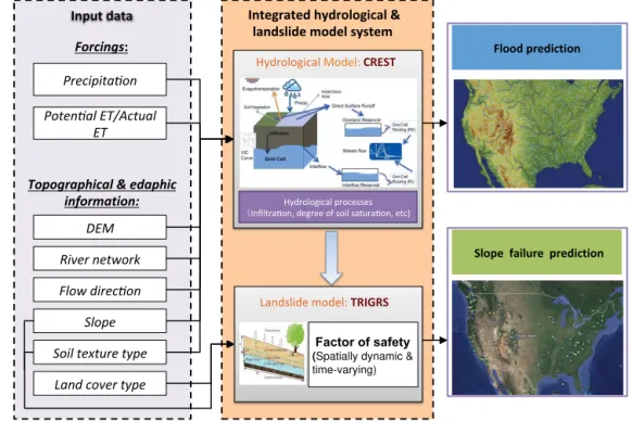
In this study, we developed an integrated modeling system in which the CREST distributed hydrological model is cou-pled with the TRIGRS landslide forecasting model (Fig. 1); therefore, the system is called “integrated CREST-TRIGRS” or iCRESTRIGRS. The CREST and TRIGRS models are briefly introduced in the following two sub-sections, while the integration method is described in detail in Sect. 2.1.3. 2.1.1 CREST model
The CREST model is a grid-based distributed hydrologi-cal model developed by the University of Oklahoma (http: //hydro.ou.edu) and NASA SERVIR project team (www. servir.net). It partitions net precipitation into surface runoff and infiltration using the variable infiltration capacity curve (VIC), a concept originating from the Xinanjiang model (Zhao, 1992; Zhao et al., 1980) and later represented in the VIC model (Liang et al., 1994, 1996). The multi-linear reser-voir concept (Wang et al., 2011) is used to represent surface and subsurface water storages in the CREST model. It uses a cell-to-cell routing scheme to route overland flow to downs-lope cells, where it is further partitioned into infiltration and overland flow moving downslope using the VIC-based runoff generation scheme; in this way, interaction between surface and subsurface water flow processes is accounted for (Wang et al., 2011; Shen et al., 2016). The SCE-UA (shuf-fled complex evolution method developed at the University of Arizona) optimization scheme (Duan et al., 1992) is im-plemented to automatically calibrate the distributed model parameters.
The CREST model has been widely used for regional to global studies, including flood inundation mapping over un-gauged basins (Khan et al., 2011), statistical and hydrolog-ical evaluation of multi-satellite precipitation products (Xue et al., 2013), and detection and prediction of extreme flood events (Y. Zhang et al., 2015). It has also been implemented in several operational systems, such as the FLASH (Flooded Locations And Simulated Hydrographs) project (http://www. nssl.noaa.gov/projects/flash/) and a near real-time global hy-drological simulation and flood monitoring demonstration system (http://eos.ou.edu).
2.1.2 TRIGRS model
The TRIGRS V2.0.06b model computes transient pore-pressure changes and attendant changes in the factor of safety (FS) due to rainfall infiltration using a two-layer system that consists of an unsaturated zone above a saturated zone (Baum et al., 2010). This model links analytical solutions for tran-sient, unsaturated, vertical infiltration above the water table (Srivastava and Yeh, 1991) to pressure–diffusion solutions for pressure changes below the water table. The solutions
are linked through a transient water table that rises as wa-ter accumulates at the base of the unsaturated zone. Pore pressures computed by the models are subsequently used in one-dimensional slope-stability computations to estimate the timing and locations of slope instability (Baum et al., 2010). The TRIGRS model assumes that water can infiltrate with a maximum infiltration rate, i.e., the saturated hydraulic con-ductivity (Ks)at each grid cell. It also has a simple surface
runoff routing scheme for water movement from cells that have excess surface water to adjacent downslope cells where it can either infiltrate or flow farther downslope. A detailed description of the TRIGRS model can be found in Baum et al. (2008, 2010).
2.1.3 Integrated model system
We integrated the CREST and TRIGRS models through one-way coupling. In this one-way, the CREST model computes all hydrologic storages and fluxes, including interception by vegetation, infiltration, runoff generation, water routing, and re-infiltration of excess surface runoff from upstream cells to downstream cells, and provides the initial conditions, e.g., soil wetness and depth of water table (Fig. 1). The CREST model feeds infiltration and its history and soil moisture con-dition into the TRIGRS model; the TRIGRS model is then implemented to compute pore pressure and slope stability correspondingly. FS in iCRESTRIGRS is calculated in the same way that the TRIGRS model does. FS is calculated as the ratio of resisting basal Coulomb friction to gravitation-ally induced downslope basal driving stress (Baum et al., 2010). FS is calculated for transient pressure heads at mul-tiple depths. In the unsaturated zone, a simple approximation for Bishop’s effective stress parameter is used in computing FS. To compute FS above the water table, the matric suction in the FS computation equation is multiplied by Bishop’s effective stress parameter. Further details can be found in Baum et al. (2010). The coupling between CREST and TRI-GRS is seamlessly executed in a distributed fashion at every time step and continuously computes runoff, infiltration, FS, pore pressure, and other water balance components at each grid cell. As shown in Fig. 1, this integrated system has an open interface that provides a utility to couple this integrated model with any other numerical weather prediction (NWP) model, climate model, or radar-/satellite-based quantitative precipitation estimation (QPE) system that provides precip-itation and other necessary weather data to form an opera-tional real-time forecasting or nowcasting system.
As mentioned above, the original TRIGRS model has its own schemes to estimate infiltration and runoff routing. In TRIGRS, it is assumed that runoff occurs when the precip-itation and runoff supplied to a cell exceed its infiltrability. The infiltrability is set to the saturated hydraulic conductivity (Ks)based on previous studies (Iverson, 2000; Hillel, 1982).
' *
' !!!
" #) !!"% #)",
Slope failureprediction
Topographical & edaphic information:
Forcings#
Input data
!*
Factor of safety (Spatially dynamic & time-varying) Integratedhydrological&
landslidemodelsystem
Floodprediction
Figure 1.The framework of the proposed integrated CREST and TRIGRS modeling system, which is able to forecast flood and rainfall-triggered landslide events.
with the limitation that infiltration cannot exceedKs(Baum
et al., 2010):
I =
P +Ru, P+Ru≤Ks
Ks, P+Ru> Ks (1)
At each cell whereP+RuexceedsKs, the excess is
consid-ered runoff (Rd)and is diverted to adjacent downslope cells: Rd=
P +Ru−Ks, P+Ru−Ks>0
0, otherwise . (2)
Overland flow between adjacent cells is assumed to occur instantaneously; thus, the rate of overland flow is not consid-ered or computed in TRIGRS. TRIGRS the enforces mass balance for each time step but does not carry runoff over from one time step to the next or track water that enters storm drains (Baum et al., 2008, 2010).
Unlike TRIGRS, the CREST model is a distributed hydro-logical model, which specializes in modeling all major sur-face hydrological processes. The rainfall–runoff generation processes in CREST start from the canopy interception. Af-terP passes the canopy layer, the excess precipitation that reaches the soil surface is net precipitation (Psoil), which is
further divided into surface runoff (R) and infiltration (I) ac-cording to the variable infiltration curve (VIC), a concept originating from the Xinanjiang model (Zhao, 1992; Zhao et al., 1980) and later represented in the VIC model (Liang et al., 1994, 1996). This model assumes that the point infil-tration capacity i, which is the maximum water depth that
can be stored in the soil column, varies over an area in the following relationship (Wang et al., 2011):
i=im
h
1−(1−a)1b i
, (3)
whereim is the maximum infiltration capacity of a cell and
is determined by soil properties;a is the fraction of a grid cell whose water capacity is less than or equal to the mean water capacity of the whole cell; andbis an empirical shape parameter. The amount of water available for infiltration can therefore be calculated as follows (Wang et al., 2011):
I=
Wm−W, i+Psoil≥im
(Wm−W )+Wm·
1−i+Psoil
im
1+b
, i+Psoil< im, (4)
where Wm and W are the cell’s maximum water
parti-^
^
^
^
36°0'0" N
35°30'0" N
35°0'0" N
36°0'0" N
35°30'0" N
35°0'0" N
82°0'0"W 82°30'0"W
83°0'0" W 83°30'0" W
36°0'0" N
35°30'0" N
35°0'0" N
82°0'0" W 82°30'0" W
83°0'0"W 83°30'0"W
36°0'0" N
35°30'0" N
35°0'0" N
Soil type Bed Rock Sand Sandy Loam Silt Loam Loam Sandy Clay Loam Silty Clay Loam Clayey Loam Sandy Clay Clay Organic
(a) (b)
(c) (d)
Land cover
Open water
Mixed Forest Closed Shrubland Grassland Wetland Cropland Built-up Vegetation Mosaic Barren Evergreen Broadleaf Deciduous Broadleaf
Slope (degree)
High : 45
Low : 0
^
GaugesRivers
DEM
High : 2100
Low : 300
North Carolina
(d)
36°0'0" N
35°30'0" N
35°0'0" N (e)
Figure 2. (a)Elevations,(b)slopes,(c)soil types,(d)land cover types, and(e)areal extent of reported individual slope movements during the study period in the study region, which include four river basins, the upper Little Tennessee River basin, Tuckasegee River basin, Pigeon River basin, and French Broad River Basin (from left to right); the inset shows the locations of the four basins within North Carolina.
tioning. Second, soil water can be increased by lateral in-terflow from upstream cells. Third, channel runoff from up-stream cells contributes to the receptor cell’s overland reser-voir depth. This implemented cell-by-cell runoff routing en-ables this model to realistically compute the spatially and temporally varying values of runoff, soil moisture and infil-tration. It also tracks the water movement through the basin. In theory, replacing the simple infiltration and runoff rout-ing schemes in TRIGRS with the more sophisticated runoff generation and routing methods in CREST will produce more realistic estimates of infiltration history in areas with nontriv-ial contributions of overland flow to infiltration. Moreover, the CREST model is able to simulate and provide necessary initial conditions and other inputs for the TRIGRS model. The iCRESTRIGRS model is, therefore, able to continuously and seamlessly simulate hydrological processes and solve pore pressure and factor of safety for each cell at each time step with available forcing data. The minimum forcing data
required to run this model are only precipitation and evapo-transpiration, making it an easily implementable model. 2.2 Case study and data
2.2.1 Study area and case study
We chose four adjacent river basins, the Upper Little Ten-nessee River basin, the Tuckasegee River basin, the Pigeon River basin, and the French Broad River basin, located in western North Carolina (Fig. 2a), as our study area. The drainage area of the four basins ranges between 1390 and 4050 km2.
totals from 52 to 351 mm across the study area (National Oceanic and Atmospheric Administration, 2004). The flood and landslide events triggered by the precipitation from Hur-ricane Ivan across western North Carolina serve as an ideal case study to test the integrated flood–landslide forecast sys-tem.
2.2.2 Input and validation data
Data used in this study include radar-measured rainfall- and satellite-based estimates of actual evapotranspiration, digital elevation models (DEM), land cover and soil texture maps, observed river streamflow from gauges, and an inventory of landslide events (Bauer et al., 2012). All gridded data were either downscaled or aggregated to a spatial resolution of 3 arcsec (3′′, i.e.,∼90 m) to ensure the forcing and
auxil-iary data match with each other. Bilinear interpolation is the method for spatial downscaling in this study, whereas area-weighted resampling is used for aggregation.
The precipitation data were from the hourly, 4 km National Stage IV Quantitative Precipitation Estimation (QPE) prod-uct based on gauge and radar observations at NCEP (Lin and Mitchell, 2005). The Stage IV data were downscaled to 3′′using bilinear interpolation. The actual evapotranspiration (ET) data were derived from a daily satellite remote-sensing-based ET record as input for the iCRESTRIGR model and are available at a spatial resolution of 8 km (Zhang et al., 2009, 2010; K. Zhang et al., 2015). The daily, 8 km ET data were first downscaled to a spatial resolution of 3′′ using bilinear interpolation and further downscaled to hourly resolution us-ing the solar zenith angle as a function of solar declination, latitude, and hour angle of each grid cell.
The 3′′ DEM (Fig. 2a), flow direction, and flow
accu-mulation data were obtained from the USGS HydroSHEDS 3′′ geo-referenced data sets (http://hydrosheds.cr.usgs.gov). These data serve as basic data for the distributed iCRE-STRIGRS model to establish topological and geomorpho-logical connections among grid cells and derive further to-pographical information such as slope (Fig. 2b). The map of soil type (Fig. 2c) was from the State Soil Geographic (STATSGO) data set, distributed by the Natural Resources Conservation Service (NRCS) of the US Department of Agri-culture. The soil texture classes were converted to 12 USDA soil texture classes plus rock and organic matter. The land cover/land use map (Fig. 2d) was derived from the 30 m Na-tional Land Cover Database (NLDC) 2011 (Homer et al., 2015). Streamflow observations from four USGS stream-flow gauges (no. 03503000 at Little Tennessee River, no. 03513000 at Tuckasegee River, no. 03460795 at Pigeon River, and no. 03453500 at French Broad River) were aggre-gated from 15 min to hourly resolution and serve as stream-flow validation data for the model.
The locations and slope movement outlines of landslide events during Hurricane Ivan shown in Fig. 2e were identi-fied by the North Carolina Geological Survey through field
-1
Figure 3. (a) Accumulated and hourly regional-average rainfalls during the 16–18 September storm period in the study region,
(b) spatial pattern of accumulated rainfall during the storm pe-riod, and(c)spatial pattern of rain peak times since 16 September, 11:00 UTC.
surveys and other remote-sensing techniques (Wooten et al., 2008; Bauer et al., 2012). The areal extent of individual slope movements ranges from 22 to 139 000 m2, with an average size of 6000 m2. The majority of these slope movement out-lines have a long and narrow shape (Fig. 2e).
2.2.3 Model parameters and initialization
val-Table 1.Summary of key parameter values used in both TRIGRS and iCRESTRIGRS in this study.
USDA soil Soil Porosity1 Saturated Friction Soil dry unit texture cohesion1 Hydraulic conductivity2 angle1 weight1
type (kPa) (m s−1) (◦) (kN m−3)
Sand 5.0 0.43 2.44×10⁻⁵ 40.0 21.0
Loamy sand 7.5 0.42 1.78×10⁻⁵ 28.5 20.5
Sandy loam 6.0 0.40 1.02×10⁻⁵ 32.0 15.0
Silt loam 9.0 0.46 2.50×10⁻⁶ 24.0 14.0
Loam 10.0 0.43 4.53×10⁻⁶ 22.5 13.0
Sandy clay loam 29.0 0.39 6.59×10⁻⁶ 20.0 15.0
Silty clay loam 50.0 0.48 1.44×10⁻⁶ 16.5 14.0
Clayey loam 35.0 0.46 2.72×10⁻⁶ 20.0 14.0
Sandy clay 24.5 0.41 4.31×10⁻⁶ 22.5 18.5
Silty clay 30.0 0.49 1.06×10⁻⁶ 18.5 18.0
Clay 40.0 0.47 1.31×10⁻⁶ 16.5 19.5
Silt 9.0 0.52 2.05×10⁻⁶ 26.5 16.5
1Values were roughly set to the means of the ranges determined from Das (2008), Hough (1969), Terzaghi et
al. (1996) and Dysli, (2000);2values were estimated by the pedotransfer equations of Cosby et al. (1984) using the mean sand and clay fractions of each soil class.
ues of model parameters at each grid cell based on its soil class rather than using very limited local measured values. For this purpose, we built a parameter look-up table based on the USDA textural soil classification. Table 1 summarizes the values of key common parameters used in both TRIGRS and iCRESTRIGRS. The values of all these parameters were roughly estimated as the means of their value ranges deter-mined from the literature. ParameterWmof the
iCRESTRI-GRS model was determined from topography using the a pri-ori estimation method developed by Yao et al. (2012), while parameterbis set to a constant (1.5) across the study region based on our past experience. For the rest of the iCRESTRI-GRS parameters that are inherited from CREST, we deter-mined their distributed values using the parameter look-up table provided by the CREST user manual (Xue et al., 2015) based on the land cover map and the soil texture map.
Because all model parameters were determined from soil types a priori, we did not conduct model calibration in this study. To minimize the uncertainty in the initial conditions, the iCRESTRIGRS model was spun up for 1 year before-hand.
2.3 Statistical metrics for evaluating model performance
To evaluate the performance of this integrated model system, we applied a suite of statistical metrics to evaluate the model results. We computed relative bias, Pearson correlation co-efficient (CC), and Nash–Sutcliffe coco-efficient of efficiency (NSCE) for the modeled hourly discharge series using the four USGS gauge stations.
To quantitatively measure the predictive capabilities of the models for landslide prediction, we calculated the confusion
matrix through comparison between the binary predictions of slope failure and the landslide inventory database. The con-fusion matrix consists of four possible outcomes (Fawcett, 2006): (1) a modeled landslide is a true one (true positive, TP), (2) a modeled landslide is a false one (false positive, FP), (3) an observed landslide is not captured by the model (false negative, FN), and (4) a grid cell is stable in both model and observation (true negative, TN). Based on the confusion matrix, a series of indices can be calculated:
TPR=TP/ (TP+FN) , (5)
TNR=TN/ (TN+FP) , (6)
09/17 09/19 09/21 09/23 0 300 600 900 1200 1500 1800 Discharge (m
s )
3
(a)
Bias= CC= NSEC=
−33.2 % 0.95 0.76
09/17 09/19 09/21 09/23 0 20 40 60 80 100 120
Rainfall (mm h )
Time
Qobs Q
iCRESTRIGRS
Rainfall
09/17 09/19 09/21 09/23 0 300 600 900 1200 1500 1800 Discharge (m
s )
3
(b)
Bias= CC= NSEC=
−15.1 % 0.91 0.75
09/17 09/19 09/21 09/23 0 20 40 60 80 100 120
Rainfall (mm h )
Time
09/17 09/19 09/21 09/23 0 300 600 900 1200 1500 1800 Discharge (m
s )
3
(c)
Bias= CC= NSEC=
−8.2 % 0.90 0.65
09/17 09/19 09/21 09/23 0 20 40 60 80 100 120
Rainfall (mm h )
Time
09/17 09/19 09/21 09/23 0 300 600 900 1200 1500 1800 Discharge (m
s )
3
(d)
Bias= CC= NSEC=
−7.2 % 0.81
−0.13
09/17 09/19 09/21 09/23 0 20 40 60 80 100 120
Rainfall (mm h )
Time -1 -1 -1 -1 -1 -1 -1 -1
Figure 4.Observed and modeled hydrographs and basin-average rainfall rates at the(a)upper Little Tennessee River basin,(b)Tuckasegee River basin,(c)Pigeon River basin, and(d)French Broad River basin.
3 Results
3.1 Characteristics of the Hurricane Ivan induced storm
Hurricane Ivan passed through western North Carolina be-tween 16 and 18 September 2004. The storm in this re-gion started around 11:00 UTC 16 September 2004 and com-pletely ceased around 03:00 UTC 18 September, while the majority of rainfall occurred in the first 24 h (Fig. 3a). It brought an average rainfall of∼130 mm within 24 h across the region (Fig. 3a), while accumulated rainfall reached max-imum values in the southern parts of the four river basins (Fig. 3b). The storm roughly moved from southwest to north-east (Fig. 3c); differences in peak time of rainfall across this region can be as large as 5 h (Fig. 3c). The storm was rapid and intense.
3.2 Model evaluation and comparison
The modeled hourly discharge series between 16 and 24 September 2004 by the iCRESTRIGRS model were com-pared with the observations at the four USGS gauge stations (Fig. 4a–d). The modeled hydrographs show generally good agreement with the observations. CC is larger than 0.80 at all stations. Relative bias falls within±34 %. The NSCE val-ues at three stations except the one located at French Broad River are larger than or equal to 0.65. The low NSCE value at the French Broad River is largely due to a time shift be-tween modeled and observed peak discharges (Fig. 4d). The delayed peak discharge in the model implies that there is
likely some uncertainty in the flow concentration and rout-ing module of the iCRESTRIGRS model. In addition, uncer-tainty in the spatial distribution of Stage IV rainfall data can also cause some uncertainty in the process of flow concen-tration. In general, the above results indicate that the iCRE-STRIGRS model is generally capable of simulating runoff process well and predicting the flood events.
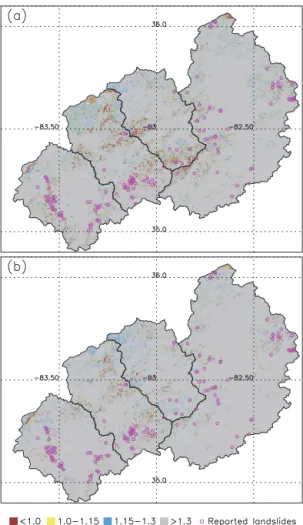
Figure 5.Comparisons(a)between TRIGRS modeled FS and re-ported landslide events, and(b)between iCRESTRIGRS modeled FS and reported landslide events.
hydrological processes, in particular the infiltration process, because the largest difference between TRIGRS and iCRE-STRIGRS lies in the way that infiltration and runoff rout-ing are computed. For the TRIGRS model, the TPR, TNR, and accuracy statistics are 59.0, 97.5, and 97.7 %, respec-tively, when FS=1 is set as a cutoff value for slope stability. For the iCRESTRIGRS model, the three metrics are 56.4, 98.8, and 98.9 %. These results indicate that the iCRESTRI-GRS model shows generally better results and that coupling the CREST distributed hydrological model with the TRIGRS model leads to an improved model performance, at least for this case study.
The ROC analysis demonstrates that the coupled system generally has higher specificity relative to the original TRI-GRS model (Fig. 6). The AUC values for the TRITRI-GRS and iCRESTRIGRS models are 0.90 and 0.92, respectively, sug-gesting that iCRESTRIGRS performs better than TRIGRS in this case study. As mentioned above and shown in Fig. 7, the largest difference between the two models lies in the model infiltration values. It is clear that the simple infiltration
0 0.2 0.4 0.6 0.8 1
0 0.1 0.2 0.3 0.4 0.5 0.6 0.7 0.8 0.9 1
AUC
TRIGRS=0.90
AUC
iCRESTRIGRS=0.92
FS=0.9 FS=1.0 FS=1.1
True negative
True positive
TRIGRS iCRESTRIGRS
Figure 6.Receiver operator characteristic (ROC) graph comparing slope-stability results from the TRIGRS and iCRESTRIGRS mod-els.
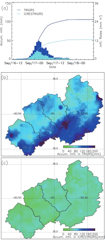
and rain excess routing schemes implemented in the TRI-GRS model lead to higher values of infiltration than in the iCRESTRIGRS model (Fig. 7a). The regional average accu-mulated infiltration during the 16–18 September storm mod-eled by TRIGRS is 104.9 mm, while the value modmod-eled by iCRESTRIGRS is just half of it, i.e., 52.2 mm (Fig. 7a). The larger infiltration rate in TRIGRS than in iCRESTRIGRS ap-pears across the whole region (Fig. 7b, c). This explains why the TRIGRS results have generally lower FS values than the iCRESTRIGRS results and why TRIGRS has a higher false positive rate than iCRESTRIGRS (Fig. 5).
3.3 Evolution of modeled cascading flood–landslide hazards
We further investigated the evolution of the storm in terms of accumulated rainfall during a 6 h period and the correspond-ing responses of hydrological processes (e.g., infiltration and overland runoff), slope stability, and pressure modeled by the iCRESTRIGRS model (Fig. 8). In Fig. 8, the rainfall and in-filtration are 6 h accumulated values, while overland runoff is the average value during each 6 h period. Factor of safety is the minimum value during each period, while pore pressure is the value at the depth and at the time corresponding to the lowest FS.
in--1
Figure 7. (a)Accumulated and hourly infiltration values from the TRIGRS and iCRESTRIGRS models, and spatial patterns of accu-mulated infiltrations from the(b)TRIGRS and(c)iCRESTRIGRS models.
filtration rate increase to some extent, especially in the Little Tennessee River and Tuckasegee River basins. The model re-sults show that overland flow starts to appear in the small trib-utaries and creeks (Fig. 8). Pore pressure reaches high values in some areas of the Little Tennessee River and Tuckasegee
River basins, resulting in some unstable slopes. These unsta-ble slopes are largely located in the areas with steep slopes. During the third 6 h period, rainfall reaches a maximum and has an accumulated value larger than 30 mm over most of the region. Correspondingly, infiltration rates also reach maxi-mum and overland runoff appears everywhere, with rapid rises of streamflow in the drainage network. The number of modeled landslides has increased dramatically, accompanied by large increases in pore pressures. As the storm enters the fourth 6 h period, rainfall and infiltration intensities decline but still maintain high levels. Pore pressures in some regions continue to rise, resulting in some new landslides. During the fifth period, rainfall and infiltration intensities are reduced greatly. Runoff on the land and in many upstream reaches of these rivers starts to subside. Pore pressure declines in many areas, but remains high in some areas in response to accumu-lative infiltration processes. The number of modeled land-slides during this period also decreases. The detailed anal-yses of rainfall and modeled hydrological and geotechnical responses on a phase-by-phase basis show that the model re-sults show reasonable responses to the evolution of the storm in space and time. It also emphasizes the cascading nature of rainfall-triggered floods and shallow landslides.
4 Conclusion and discussion
This study presents a new, coupled model system, which in-tegrates the CREST distributed hydrological model with the TRIGRS landslide model for flood and landslide forecast-ing. Driven by the hydrological states and fluxes modeled by CREST, iCRESTRIGRS improves over TRIGRS by pro-viding more accurate initial conditions such as degree of soil saturation and depth of the water table. Furthermore, CREST specializes in the simulation of hydrological processes and fluxes and can thus provide more realistic hydrological fluxes such as infiltration for TRIGRS, leading to better accuracy for landslide forecasting. The case study demonstrates that the integrated model shows better results than the stand-alone TRIGRS model for landslide forecasting.
The modeling system presented in this study is also de-veloped as a framework and is able to adopt other hydro-logical models and landslide models as alternatives to com-pute hydrological processes and soil stability. Therefore, this can be easily expanded to build an ensemble-based system. This coupled modeling system has low requirements for in-put data as well, making it easy to couple with other numeri-cal weather prediction models and real-time QPE forcings.
proper--1
Accum. precip. (mm) Accum. infil. (mm) Mean runoff (m s )3 FS Pressure head (m)
Figure 8.Maps showing the evolution of storms (rainfall), hydrological responses such as infiltration and runoff, slope stability, and pressure head at the depth corresponding to the lowest factor of safety.
ties, improved model formulation, and more information on fine-scale topography likely help improve model accuracy, because hydrological processes are highly scale-dependent (Yu et al., 2014). In particular, slope stability is highly pendent on the steepness of hillslopes, which is highly de-pendent on the model’s spatial resolution. In this study, the grid spacing is set to 90 m rather than a finer resolution
sta-ble areas, respectively. Introducing parallel computing into the iCRESTRIGRS model using a new message passing in-terface (MPI) version of TRIGRS (Alvioli and Baum, 2016) will facilitate the application of the iCRESTRIGRS model at a finer resolution. Additional evaluation of this model in larger regions and under different conditions will better sup-port the predictive capability and robustness of this model.
5 Data availability
The DEM data are available from http://hydrosheds.cr.usgs. gov. The streamflow data are provided by the USGS (https: //waterdata.usgs.gov), while the landcover data are avail-able through http://www.mrlc.gov/nlcd2011.php. Landslide records are available upon request to Rick Wooten, while all other data are available upon request to Ke Zhang.
Acknowledgements. This research was funded by the NOAA/Office of Oceanic and Atmospheric Research under NOAA–University of Oklahoma Cooperative Agreement no. NA14OAR4830100, the NASA Surface and Interior program (NNH10ZDA001N-ESI), Fundamental Research Funds for the Central Universities (2015B28514) and the National Natural Science Foundation of China (71461010701).
Edited by: T. Bogaard
Reviewed by: two anonymous referees
References
Abbott, M. B., Bathurst, J. C., Cunge, J. A., O’Connell, P. E., and Rasmussen, J.: An introduction to the European Hydrologic Sys-tem – SysSys-teme Hydrologique Europeen, “SHE” 1: history and philosophy of a physically based distributed modeling system, J. Hydrol., 87, 45–59, 1986.
Alfieri, L., Burek, P., Dutra, E., Krzeminski, B., Muraro, D., Thie-len, J., and Pappenberger, F.: GloFAS – global ensemble stream-flow forecasting and flood early warning, Hydrol. Earth Syst. Sci., 17, 1161–1175, doi:10.5194/hess-17-1161-2013, 2013. Alvioli, M. and Baum, R. L.: Parallelization of the TRIGRS model
for rainfall-induced landslides using the message passing inter-face, Environ. Modell. Softw., 81, 122–135, 2016.
Arnone, E., Noto, L. V., Lepore, C., and Bras, R. L.: Physically-based and distributed approach to analyze rainfall-triggered land-slides at watershed scale, Geomorphology, 133, 121–131, 2011. Ashley, S. T. and Ashley, W. S.: Flood fatalities in the United States,
J. Appl. Meteorol. Clim., 47, 805–818, 2008.
Bauer, J. B., Fuemmeler, S. F., Wooten, R. M., Witt, A. C., Gillon, K. A., and Douglas, T. J.: Landslide hazard mapping in North Carolina – overview and improvements to the program, Proceed-ings of the 11th International Symposium on Landslides and 2nd North American Symposium on Landslides, Banff, Alberta, Canada, 2012, 257–263, 2012.
Baum, R. L., Savage, W. Z., and Godt, J. W.: TRIGRS–A For-tran program for For-transient rainfall infiltration and grid-based
re-gional slope-stability analysis, Version 2.0, US Geological Sur-vey Open-File Report, 2008–1159, 75, 2008.
Baum, R. L., Godt, J. W., and Savage, W. Z.: Estimating the tim-ing and location of shallow rainfall-induced landslides ustim-ing a model for transient, unsaturated infiltration, J. Geophys. Res., 115, F03013, doi:10.1029/2009jf001321, 2010.
Begueria, S.: Validation and evaluation of predictive models in haz-ard assessment and risk management, Nat. Hazhaz-ards, 37, 315– 329, 2006.
Beven, K. J. and Kirkby, M. J.: A physically based, variable con-tributing area model of basin hydrology, Hydrological Sciences-Bulletin-des Sciences Hydrologiques, 24, 43–69, 1979. Bogaard, T. and Greco, R.: Preface “Hillslope hydrological
mod-elling for landslides prediction”, Hydrol. Earth Syst. Sci., 18, 4185–4188, doi:10.5194/hess-18-4185-2014, 2014.
Budimir, M. E. A., Atkinson, P. M., and Lewis, H. G.: Earthquake-and-landslide events are associated with more fatalities than earthquakes alone, Nat. Hazards, 72, 895–914, 2014.
Camera, C., Apuani, T., and Masetti, M.: A coupled distributed hydrological-stability analysis on a terraced slope of Valtellina (northern Italy), Hydrol. Earth Syst. Sci. Discuss., 10, 2287– 2322, doi:10.5194/hessd-10-2287-2013, 2013.
Clark III, R., Flamig, Z., Vergara, H., Hong, Y., Gourley, J. J., Mandl, D., Frye, S., Handy, M., and Patterson, M.: Hydrological Modeling and Capacity Building in the Republic of Namibia, B. Am. Meteorol. Soc., doi:10.1175/BAMS-D-15-00130.1, 2016. Coe, J. A., Kean, J. W., Godt, J. W., Baum, R. L., Jones, E. S.,
Gochis, D. J., and Anderson, G. S.: New insights into debris-flow hazards from an extraordinary event in the Colorado Front Range, GSA Today, 24, 4–10, 2014.
Cosby, B. J., Hornberger, G. M., Clapp, R. B., and Ginn, T. R.: A Statistical Exploration of the Relationships of Soil-Moisture Characteristics to the Physical-Properties of Soils, Water Resour. Res., 20, 682–690, 1984.
Crawford, N. H. and Linsley, R. S.: Digital simulation in hydrol-ogy: The Stanford Watershed Model IV, Technical Report No. 39, Department of Civil Engineering, Stanford University, Palo Alto, California, 1966.
Das, B.: Adanced soil mechanics, Taylor & Francis, London, New York, 2008.
Dietrich, W. E., Reiss, R., Hsu, M. L., and Montgomery, D. R.: A Process-Based Model for Colluvial Soil Depth and Shallow Landsliding Using Digital Elevation Data, Hydrol, Process„ 9, 383–400, 1995.
Dilley, M., Chen, R. S., Deichmann, U., Lerner-Lam, A. L., Arnold, M., Agwe, J., Buys, P., Kjekstad, O., Lyon, B., and Yetman, G.: Natural disaster hotspots: a global risk analysis synthe-sis report, International Bank for Reconstruction and Develop-ment/The World Bank and Columbia University, Washington, DC, 2005.
Duan, Q. Y., Sorooshian, S., and Gupta, V.: Effective and Effi-cient Global Optimization for Conceptual Rainfall-Runoff Mod-els, Water Resour. Res., 28, 1015–1031, 1992.
Dysli, M.: Swiss Standard SN 670 010b, Characteristic Coefficients of soils, Strasse und Verkehr, 86, 93–94, 2000.
Fawcett, T.: An introduction of ROC analysis, Pattern Recogn. Lett., 27, 861–874, 2006.
Godt, J. W., Baum, R. L., and Lu, N.: Landsliding in par-tially saturated materials, Geophys. Res. Lett., 36, L02403, doi:10.1029/2008GL035996, 2009.
Gourley, J. J., Flamig, Z. L., Hong, Y., and Howard, K. W.: Evalu-ation of past, present and future tools for radar-based flash-flood prediction in the USA, Hydrolog. Sci. J., 59, 1377–1389, 2014. Hillel, D.: Introduction to soil physics, Academic Press, San Diego,
California, 1982.
Homer, C., Dewitz, J., Yang, L. M., Jin, S., Danielson, P., Xian, G., Coulston, J., Herold, N., Wickham, J., and Megown, K.: Com-pletion of the 2011 National Land Cover Database for the Con-terminous United States – Representing a Decade of Land Cover Change Information, Photogramm. Eng. Rem. S., 81, 345–354, 2015.
Hong, Y., Adler, R., and Huffman, G.: Evaluation of the potential of NASA multi-satellite precipitation analysis in global landslide hazard assessment, Geophys. Res. Lett., 33, 440–452, 2006. Hough, B.: Basic soil engineering, Ronald Press Company, New
York, 1969.
Hsu, W. K., Huang, P. C., Chang, C. C., Chen, C. W., Hung, D. M., and Chiang, W. L.: An integrated flood risk assessment model for property insurance industry in Taiwan, Nat. Hazards, 58, 1295– 1309, 2011.
Iverson, R. M.: Landslide triggering by rain infiltration, Water Re-sour. Res., 36, 1897–1910, 2000.
Kappes, M. S., Keiler, M., and Glade, T.: From single- to multi-hazard risk analyses: a concept addressing emerging challenges, in: Mountain Risks: Bringing Science to Society, edited by: Malet, J. P., Glade, T., and Casagli, N., CERG Editions, Stras-bourg, France, 351–356, 2010.
Khan, S. I., Hong, Y., Wang, J. H., Yilmaz, K. K., Gourley, J. J., Adler, R. F., Brakenridge, G. R., Policelli, F., Habib, S., and Ir-win, D.: Satellite Remote Sensing and Hydrologic Modeling for Flood Inundation Mapping in Lake Victoria Basin: Implications for Hydrologic Prediction in Ungauged Basins, IEEE T. Geosci. Remote, 49, 85–95, 2011.
Kirschbaum, D. B., Adler, R., Hong, Y., Hill, S., and Lerner-Lam, A.: A global landslide catalog for hazard applications: method, results, and limitations, Nat. Hazards, 52, 561–575, 2010. Lanni, C., Borga, M., Rigon, R., and Tarolli, P.: Modelling shallow
landslide susceptibility by means of a subsurface flow path con-nectivity index and estimates of soil depth spatial distribution, Hydrol. Earth Syst. Sci., 16, 3959–3971, doi:10.5194/hess-16-3959-2012, 2012.
Lepore, C., Arnone, E., Noto, L. V., Sivandran, G., and Bras, R. L.: Physically based modeling of rainfall-triggered landslides: a case study in the Luquillo forest, Puerto Rico, Hydrol. Earth Syst. Sci., 17, 3371–3387, doi:10.5194/hess-17-3371-2013, 2013. Liang, X., Lettenmaier, D. P., Wood, E. F., and Burges, S. J.: A
simple hydrologically based model of land surface water and en-ergy fluxes for general circulation models, J. Geophys. Res., 99, 14415–14428, 1994.
Liang, X., Wood, E. F., and Lettenmaier, D. P.: Surface soil moisture parameterization of the VIC-2L model: Evaluation and modifica-tion, Global Planet. Change, 13, 195–206, 1996.
Liao, Z., Hong, Y., Wang, J., Fukuoka, H., Sassa, K., Karnawati, D., and Fathani, F.: Prototyping an experimental early warning system for rainfall-induced landslides in Indonesia using satellite
remote sensing and geospatial datasets, Landslides, 7, 317–324, 2010.
Lin, Y. and Mitchell, K. E.: The NCEP Stage II/IV hourly precipita-tion analyses: development and applicaprecipita-tions, 19th Conference on Hydrology, American Meteorological Society, San Diego, CA, 9–13 January, 2005.
Lu, N. and Godt, J.: Infinite slope stability under steady unsaturated seepage conditions, Water Resour. Res., 44, 2276–2283, 2008. May, F.: Cascading disaster models in Postburn flash flood, The fire
environment–innovations, management, and policy, Destin, FL, 26–30 March 2007.
Mignan, A., Wiemer, S., and Giardini, D.: The quantification of low-probability-high-consequences events: part I. A generic multi-risk approach, Nat. Hazards, 73, 1999–2022, 2014. National Oceanic and Atmospheric Administration: Storm data,
Na-tional Climatic Data Center, 46, 1–262, 2004.
Raia, S., Alvioli, M., Rossi, M., Baum, R. L., Godt, J. W., and Guzzetti, F.: Improving predictive power of physically based rainfall-induced shallow landslide models: a probabilistic ap-proach, Geosci. Model Dev., 7, 495–514, doi:10.5194/gmd-7-495-2014, 2014.
Shen, X., Hong, Y., Zhang, K., and Hao, Z.: Refining a distributed linear reservoir routing method, J. Hydrol. Eng., 04016061, doi:10.1061/(ASCE)HE.1943-5584.0001442, 2016.
Simoni, S., Zanotti, F., Bertoldi, G., and Rigon, R.: Modelling the probability of occurrence of shallow landslides and channelized debris flows using GEOtop-FS, Hydrol. Process., 22, 532–545, doi:10.1002/hyp.6886, 2008.
Spiker, E. C. and Gori, P. L.: National landslide hazards mitigation strategy – a framework for loss reduction, US Department of the Interior and US Geological Survey, Reston, Virginia, 2003. Srivastava, R. and Yeh, T. C. J.: Analytical Solutions for
One-Dimensional, Transient Infiltration toward the Water-Table in Homogeneous and Layered Soils, Water Resour. Res., 27, 753– 762, doi:10.1029/90wr02772, 1991.
Sugawara, M., Watanabe, I., Ozaki, E., and Katsugama, Y.: Tank model with snow component. Research Notes of the National Re-search Center for Disaster Prevention No. 65, Science and Tech-nolgoy, Ibaraki-Ken, Japan, 1984.
Tao, J. and Barros, A. P.: Coupled prediction of flood response and debris flow initiation during warm- and cold-season events in the Southern Appalachians, USA, Hydrol. Earth Syst. Sci., 18, 367– 388, doi:10.5194/hess-18-367-2014, 2014.
Terzaghi, K., Peck, R., and Mesri, G.: Soil Mechanics in Engineer-ing Practice, Wiley, New York, 1996.
Uccellini, L. W., Suffern, P., Harding, K., Brown, V., Keeney, J., Stammer, K., and Stefkovich, J.: Service assessment: May 2013 Oklahoma tornadoes and flash flooding, US Department of Com-merce, National Oceanic and Atmospheric Administration, Na-tional Weather Service, Silver Spring, Maryland, 42, 2014. Wang, J. H., Yang, H., Li, L., Gourley, J. J., Sadiq, I. K., Yilmaz,
K. K., Adler, R. F., Policelli, F. S., Habib, S., Irwn, D., Limaye, A. S., Korme, T., and Okello, L.: The coupled routing and excess storage (CREST) distributed hydrological model, Hydrolog. Sci. J., 56, 84–98, 2011.
Wigmosta, M. S., Vail, L. W., and Lettenmaier, D. P.: A distributed hydrology-vegetation model for complex terrain – Reply, Water Resour. Res., 32, 213–214, 1996.
Williams, J. R. and Hann, R. W.: Optimal operation of large agricul-tural watersheds with water quality constraints. Technical Report No. 96., Texas Water Resoources Institute, Texas A&M Univer-sity, 1978.
Wooten, R. M., Gillon, K. A., Witt, A. C., Latham, R. S., Douglas, T. J., Bauer, J. B., Fuemmeler, S. J., and Lee, L. G.: Geologic, ge-omorphic, and meteorological aspects of debris flows triggered by Hurricanes Frances and Ivan during September 2004 in the Southern Appalachian Mountains of Macon County, North Car-olina (southeastern USA), Landslides, 5, 31–44, 2008.
Wu, H., Adler, R. F., Tian, Y. D., Huffman, G. J., Li, H. Y., and Wang, J. J.: Real-time global flood estimation using satellite-based precipitation and a coupled land surface and routing model, Water Resour. Res., 50, 2693–2717, 2014.
Xue, X., Hong, Y., and Zhang, K.: CREST User Manual, in, Uni-versity of Oklahoma, Norman, Oklahoma, USA, 63, 2015. Xue, X. W., Hong, Y., Limaye, A. S., Gourley, J. J., Huffman, G. J.,
Khan, S. I., Dorji, C., and Chen, S.: Statistical and hydrological evaluation of TRMM-based Multi-satellite Precipitation Analy-sis over the Wangchu Basin of Bhutan: Are the latest satellite pre-cipitation products 3B42V7 ready for use in ungauged basins?, J. Hydrol., 499, 91–99, 2013.
Yao, C., Li, Z., Yu, Z. B., and Zhang, K.: A priori parameter estimates for a distributed, grid-based Xinanjiang model using geographically based information, J. Hydrol., 468–469, 47–62, 2012.
Yu, Z. B., Lu, Q. G., Zhu, J. T., Yang, C. G., Ju, Q., Yang, T., Chen, X., and Sudicky, E. A.: Spatial and Temporal Scale Effect in Sim-ulating Hydrologic Processes in a Watershed, J. Hydrol. Eng., 19, 99–107, 2014.
Zhang, K., Kimball, J. S., Mu, Q., Jones, L. A., Goetz, S. J., and Running, S. W.: Satellite based analysis of northern ET trends and associated changes in the regional water balance from 1983 to 2005, J. Hydrol., 379, 92–110, 2009.
Zhang, K., Kimball, J. S., Nemani, R. R., and Running, S. W.: A continuous satellite-derived global record of land surface evapotranspiration from 1983 to 2006, Water Resour. Res., 46, W09522, doi:10.1029/2009WR008800, 2010.
Zhang, K., Kimball, J. S., Nemani, R. R., Running, S. W., Hong, Y., Gourley, J. J., and Yu, Z. B.: Vegetation Greening and Climate Change Promote Multidecadal Rises of Global Land Evapotran-spiration, Scientific Reports, 5, 15956, doi:10.1038/srep15956, 2015.
Zhang, Y., Hong, Y., Wang, X. G., Gourley, J. J., Xue, X. W., Sa-haria, M., Ni, G. H., Wang, G. L., Huang, Y., Chen, S., and Tang, G. Q.: Hydrometeorological Analysis and Remote Sensing of Extremes: Was the July 2012 Beijing Flood Event Detectable and Predictable by Global Satellite Observing and Global Weather Modeling Systems?, J. Hydrometeorol., 16, 381–395, 2015. Zhao, R. J.: The Xinanjiang model applied in China, J. Hydrol., 135,
371–381, 1992.