Geology and Slope Stability Analysis using Markland Method on Road Segment
of Piyungan – Patuk, Sleman and Gunungkidul Regencies, Yogyakarta Special
Region, Indonesia
B. N. Kresna Citrabhuwana
*, Sari Bahagiarti Kusumayudha, Purwanto
Universitas Pembangunan Nasional “Veteran” Yogyakarta, Indonesia.
*
E-mail: citrabhuwana@gmail.com
Received:15 February, 2016 Revised: 8 June, 2016 Abstract. Road segment of Piyungan - Patuk is a part of Yogyakarta - Wonosari highway, fairly dense traversed by vehicles, from bicycles to buses and trucks. This road crosses hilly topography, causing its sides bounded by quite steep slopes or cliffs. Steep slopes and cliffs are potential to create mass movement. Geologic condition of the surrounding area is built of various volcanic lithology such as breccia, siltstone, sandstone and tuff. There are also geologic structures of joints and faults that affect the stability of the slopes around this road. Slope stability analysis for road segment of Piyungan – Patuk was conducted by applying Markland method. Laboratory testings were done to determine the mechanical and physical properties of rocks that influence the slope strength. Results of the testings show that cohesion and friction angle of volcanic breccia are c = 20.0441 kg/cm2 and f = 56.38˚; cohesion and friction angle of sandstone are cr = 0.6862 kg/cm2, cp = 4.6037 kg/cm2, fr = 26.37˚, and fp = 32.79˚; cohesion and friction angle of tuff is cr = 1.677 kg/cm2, cp = 7.5553 kg/cm2, fr = 17.85˚, and fp = 24.19˚. Based on the analysis, some slopes in the study area are potential to move. The movements can be classified into rock fall, debris fall, and rock slides with the sliding plane categorized as planar and wedge. On the other hand, landslide prone zones in the study area can be divided into: Areas with high vulnerability, Areas with moderate vulnerability, and Areas with low vulnerability. Areas prone to landslide should be managed by a series of measures, among others understand natural phenomena, recognizing symptoms of avalanche, attempting to reduce the risk, and land use regulation. The management activities should involve all stakeholders in an integrated manner of implementation.
Keywords: Road segment, Markland method, slope stability, factor of safety, vulnerability.
Introduction
Geological conditions, topography in the form of a ridge, steep slopes and cliffs, as well as geologic structure are natural factors that affect stability of the slopes around road segment of Piyungan – Patuk, Sleman and Gunungkidul regencies, Yogyakarta Special region, Indonesia. According to Mardiatno et al, (2001), landslides frequently occur in the area of Piyungan - Patuk and surroundings. Referring to this, it is necessary to do such geological and engineering geological work to obtain adequate data related to stability of the slope in order for preventing and controlling the occurrence of landslides which may cause such a serious impact.
Objectives of this study are to map and assess the geologic condition, geomorphology, lithologic variation and distribution, stratigraphic composition, and geologic structures. Further, it is used to determine the stability of some slopes at the edge of the road segment of Piyungan - Patuk, particularly that occupied by fresh rock.
The study area is situated along the road segment of Piyungan - Patuk and surrounding, including the
area of Sleman and Gunungkidul regencies, Yogyakarta Special region, Indonesia (Fig. 1). It is accessible easily from Yogyakarta city, about 10 - 12 km to the south. Geographically, it is located between latitudes 7.50˚02 '- 7.52˚13' south latitude and 110.27˚53 '- 110.30˚36' eastern longitude or by Universal Transverse Mercator (UTM) on the coordinate 441000mE - 446000mE and 9130000mN - 9134000mN.
Method of Study and Literature Review
Slope Stability Analysis on Road Segment of Piyungan – Patuk was done by applying Markland Method. Field survey and engineering geological mapping were also done, along with rock petrological analysis and rock properties laboratory testing to obtain the values of rock strength including friction angle and cohesion force.
On such a slope, there is force or stress system that when the equilibrium is disturbed, it will create mass movement. According to rock mechanics principle, stress distribution of a slope is displayed in Fig. 2.
Int. j. econ. environ. geol. Vol:7(1) 42-52, 2016 www.econ-environ-geol.org
Slopes composed of hard and coherent rock are in general characterized by the occurrence of stress that is different from that of slopes occupied of weathered rock or soil. Slope of soil is much weaker and looser than slope of rock (Evans, 2006, Price, 2009). The stability of slopes occupied by soil are totally influenced by shear strength of the soil, while the
stability of slopes composed by rocks, stability is affected by the shear strength of the rock and influenced by the presence of geological structures (Karnawati, 2002). The presence of rock discontinuities constituting the slope for some cases
often trigger potential avalanche (Hoek & Bray, 1981, Kusumayudha & Ciptahening, 2016).
There are various rock discontinuities such as bedding, foliation, cleavages, crack, joint, fault, and unconformity planes that are capable of behaving as the sliding plane in some mass movement occurrences
(Kusumayudha, 1993, Kusumayudha & Koesnaryo, 2001). In relation with rock slope movement, such as analytical method utilizing stereographic plot, significantly helped in slope stability study was stated by (Kusumayudha, 1996). This method is described in Fig. 1 Map showing location of the study area, road segment of Piyungan – Patuk.
G = weight force α = slope inclination
Φ = friction angle of rock mass and the sliding plane c = cohesion force
detail by Hoek & Bray (1981). Markland method classifies types of rock mass movements in stereographic projections as shown in Figure 3.
Referring to Hoek & Bray (1981), types of rockmass movement includes planar slide, wedge, and tople. Whatever the type of movement, stability of such a slope is quantitatively repressented by its factor of safety (FS). In general, factor of safety of a slope can be determined by using equation:
= ∑∑ ... (1)
When the value of FS is higher than 1.0, it means that the slope is stable. If FS equals to 1, it can be stated that the slope is in critical condition. While FS is less than 1.0, meaning that the slope fails (Hoek & Bray, 1981; Franklin & Dussault, 1989, Goodman, 1989).
Especially for wedge type of failure, Hoek & Bray (1981) provided a method to determine factor of safety, based on configuration in the Fig. 3, as the following:
where
cA and cB is cohesion value of plane A and plane B,
Fig. 3 Stereographic projection of slope failure model by Markland (Hoek & Bray, 1981).
Int. j. econ. environ. geol. Vol:7(1) 42-52, 2016 www.econ-environ-geol.org
ϕA and ϕB the friction angle value of plane A and
plane B, γ is rock wight
γW rock weght in water
H height of the wedge,
X, Y, A, and B geometrical factors of the wedge.
= ... (5)
= ... (6)
= ………...(7)
= ...(8) Fig. 5 Geologic map of area surrounding the road segment of Piyungan – Patuk.
(a)
(b)
Results and Discussion
Geologic Condition
Road segment of Piyungan - Patuk is physiographic-cally situated in the Southern Mountains Zone of Central Java - East Java (Van Bemmelen, 1949). This mountainous area can be divided into 3 sub-zones,
namely ridge of Baturagung - Stage - Plopoh in the North, Wonosari Plateau in the middle, and Gunungsewu sub-zones in the South parts. Referring to Van Zuidam (1983), Verstapen (1983) classifications, and Kusumayudha et.al (2015), geomorphology of the study area can be divided into two units of ridge landform unit and alluvial plain landform unit. Ridge unit is characterized by slope with 30% to 70% inclination, affected by lithology, geologic structure, and exogenous processes such as erosion and denudation. The ridge has a Southwest-Northeast axis, which is sequentially connecting with the longitudinal axis of Baturagung Mountains that West - East. On the other hand, alluvial plain displays less than 8% inclination.
Stratigraphy of the study area is set by three (3) rock units, including Tuffaceous Sandstone unit of Semilir formation, Volcanic Breccias unit of Nglanggran Formation and Alluvial Deposit, from older to younger respectively.
Tuffaceous sandstone unit consists of sandstone, pumice tuff, lapilli tuff, lapilli pumice, pumice breccia and shale. Composition of the pumice tuff varies from andesitic to dacitic. At River Opak, Watuadeg, Jogotirto Village, there is a basaltic andesite lava flows with pillow structure (Bronto, et.al, 2008). Volcanic breccia unit consists of pyroclastic breccias, laharic breccias, agglomerate and lava. Fragments of the
breccias are composed of andesite and basalt, 20 to 50 cm diametrical size. In the middle part of the rock unit, there are reef limestones found in the form of lenses or fragments (Suyoto, 1994). Locally, this formation inserted by well bedded epiclastic sediments such as sandstone and tuff. Alluvial deposits is sedimented by river system and flooding, composed of various materials with grain sizes diverse from clay, silt, sand to boulders. Figure 4 shows the geologic map of the study area.
Joints and fissures are geological structure caused by stresses, either compressional or tensional. Based on their origin and shape, fissure structures in the study area are classified into shear joint, which refer to Billing (1979) can be used to determine the main direction of the major stresses ( σ1, σ2, dan σ3) (Fig 6).
There is a fault that the tracks are clearly recorded on such a tuffaceous sandstone outcrop on one edge of road segment of Piyungan – Patuk (Fig 7). Position of Fig. 7 Fault cross cutting tuffaceous sandstones and silts of Semilir Formation in such an edge of road segment Patuk
– Piyungan.
Table 1 Result of rock properties testing.
Rock type
Rock Properties
Cohession force ( c )
Friction angle (α)
Peak
Residual
Peak
Residual
Volcanic breccia
c = 20.0441 kg/cm
2c = 56.38˚
Int. j. econ. environ. geol. Vol:7(1) 42-52, 2016 www.econ-environ-geol.org
the fault plane is N077°E/83°. In accordance with the classification of Rickard (1972) vide Billings (1979), using measurement data in the form of rake = 9°, Plunge = 7°, and bearing = N256E°, the fault type belongs to left slip lateral fault.
Slope Stability Analyses
Markland method application was done by plotting the data of strike and dip of discontinuity planes, friction angle of the rock, and strike - dip of the slope face of such a slope into stereonet as done by Kusumayudha (1996). There were some locations that assumed to be moderately to highly potential for slope instability,
namely LP 2, LP 3 and LP 54. In order to complete the analyses, rock properties testing was done, especially to obtain values of cohesion force and friction angle, as the result shown in Table 1.
Slope located at LP 2 is occupied by well bedded sandstone and tuff of Semilir Formation. The location is on the coordinate of x: 442580 and y: 9133512 (UTM). Strike and dip of bedding plane is N120oE/31o,
while the slope face is N230˚E/83˚. Fig. 8 shows configuration of the slope with various values of friction angle.
Fig. 8 Slope stereo plot analysis of LP 2.
Slope at LP 3 is occupied by volcanic breccias of Nglanggran Formation. There is no bedding identified, but joints of various strikes and dips. LP 3 is situated on the coordinate of x: 443003 and y: 9133140 (UTM).
Slope plane position is N192˚E/80˚. Fig. 9 is the stereo plot of the slope condition.
Slope at LP 54 is occupied by tuffaceous sandstone and tuff of Semilir Formation with bedding orientation relatively northeast – southwest dipping less than 20o,
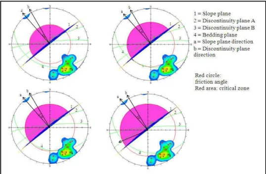
located on the coordinate x: 0442691 dan y: 09133557 (UTM). There is a slope with height = 2,7M, N282˚E/85˚position. The slope plays as the wall side of road segment Piyungan-Patuk, no vegetation. Stereo Fig. 10 Slope stereo plot analysis on sandstone with peak friction angle (cp) of LP 54.
Fig. 11 Slope stereo plot analysis on sandstone with residual friction angle (cr) of LP 54.
Int. j. econ. environ. geol. Vol:7(1) 42-52, 2016 www.econ-environ-geol.org
plots with various values of friction angle of the slope are shown in the Figures 10, 11, 12, and 13.
Based on the results of Markland analysis, the slope of LP 54 is potential for wedge failure through the plane of intersection involving two discontinuities of plane A and plane C. Table 2 and Figure 14 display components used to derive the safety factor of wedge failure in LP 54.
Result of computation using both peak and residual values of friction angles and cohesion force shows that the safety factor of slope at LP 54 is less than 1. It indicates that the slope is unstable. Based on data obtained from various ways of analysis including from stereo net plotting especially for rock, dips software for soil, safety factor analysis, and direct field observation, the stability of the slope in the study area is concluded in Table 5.
Fig. 13 Slope stereo plot analysis on tuff with residual friction angle (cr) of LP 54.
Table 2 Slope analysis parameter at LP 54.
Plane Dip˚ direction˚ Dip Properties
sandstone tuff
A 87o N314E
cp = 32.79˚, cp = 4,6037 kg/cm2
cr = 26.37˚, cr = 0,6862 kg/cm2
γ = 2.25 gr/cm3
γW = 1 gr/cm3
cp = 24.19˚, cp = 7.5553 kg/cm2
cr = 17.85˚, cr = 1.6789 kg/cm2
γ = 2.20 gr/cm3
γW = 1 gr/cm3
B 87o N121E
slope face 85o N12E
upper
surface 4o N14E
Height of the wedge, H = 270 cm
Derived from slope inclination variation, related to slope failure vulnerability in the study area, the zones can be divided into high vulnerability with slope inclination more than 30% medial vulnerability with inclined slope (8 % - 30%) and low vulnerability with gentle slope (less than 7%). Zone with high vulnerability is located on the toe of slope near by the road segment of Patuk town, with steep slope (31% - 70%), occupied by tuffaceous sandstone and tuff, jointed and faulted, weathered rock; Zone with medial vulnerability is situated on road segment from Patuk to Wonosari, inclined slope (8% - 15%), dominated by
volcanic breccias, jointed and faulted weathered rock; While zone with low vulnerability is coincided to alluvial plain landform with gentle slope (less than 7%). This area is very low potential of slope failures.
Recommendations
Counter measures to prevent slope instability of road segment Piyungan – Patuk can be done referring to Mardiatno et.al (2001), Hardiyatmo (2006) and Price (2009) as follows:
Table 3 Computation for factor safety analysis of LP 54.
Data Input Function Values Computation
fa = 87˚
fb = 87˚
f5 = 65˚
θna.nb = 165.69˚
Cos fa = 0.0523
Cos fb = 0.0523
Sin f5 = 0.9063
Cos θna.nb = -0.969
Sin θna.nb = 0.2472
=cosfsinf cossinf cos .
. =
0.0523 + 0.0523 × 0.969
0.9063 × (0.2472) = 1.9
=cosfsinf cossinf cos .
. =
0,0523 + 0,0523 × 0,969
0,9063 × (0,2472) = 1.9
θ24 = 79.83˚
θ45 = 61.15˚
θ2.na = 85.1˚
Sin θ24 = 0.9843
Sin θ45 = 0.8759
Cos θ2.na = 0.0854
=sin sincos
. =
0.9843
0.8759 × 0.0854 = 13.2
θ13 = 83.41˚
θ35 = 62.2˚
θ1.nb = 84.51˚
Sin θ13 = 0.9934
Sin θ35 = 0.8846
Cos θ1.nb = 0.0957
=sin sincos
. =
0.9934
0.8846 × 0.0957= 11.7
Table 5 List of slope stability analysis results of the study area.
Location Rock Type and Properties Stability Class Type of Slope Failure Potential
LP 2 Sandstone and tuffs Stable Low potential for planar failre
LP 3 Volcanic breccias Stable Low potential for debris fall
LP 9 Sandstone and tuffs Stable Low potential of debris slide
LP 10 Sandstone and tuffs Stable Low potential of debri fall
LP 12 Sandstone and tuffs Stable Low potential of wedge and debris fall
LP 13 Sandstone and tuffs Stable -
LP 17 Sandstone and tuffs Stable Low potential of debri fall
LP 18 Sandstone and tuffs Stable Low potential of wedge, rock fall, and
debris fall
LP 34 Sandstone and tuffs Stable -
LP 54 Sandstone and tuffs Unstable High potential of wedge failure
Int. j. econ. environ. geol. Vol:7(1) 42-52, 2016 www.econ-environ-geol.org
a. Avoiding uncontrol logging, but developing slope stability based agricultural system by appropriate plantation of landslides friendly farming system. b. Benching, retaining wall with horizontal drainage
system to decrease soil/rock water content.
c. Proper land management in the landslide prone
area.
d. Proper draining system for the area located above slopes prone to landslide
e. Feeling the open cracks when occur, using clay or
soil.
Plants can be used for counter measures are that with specification of tap root system and less branches, such as Tamarindus indicus, and Aleurites moluccana, that are useful and fit for area with elevation of 1000 m asl;
Pterocarpus indicus, Dalbergia latifolia, Cassia fistula, and Cassia siamea are proper for area with elevation about 700 m asl; Leucaena leucocephal is
appropriate for area with elevation of less than 500 m
asl; Homalium tomentosum for area of lower than 300
m asl, and Acacia villosa can be planted on the area of elevation < 300 m asl
Conclusions
Conclusions of study on the geologic condition and slope stability analysis using Markland method of road segment Piyungan – Patuk, Sleman and Gunungkidul Regencies, Yogyakarta Special Region, Indonesia are as the following:
a. The area is geologically built of Tuffaceous
sandstone and tuff of Semilir Formation, volcanic breccias of Nglanggran Formation, and alluvial deposits. There are joints and fault that make the area threatened by slope instability due to the existence of discontinuity planes.
b. Based on Markland analysis, slope which is
potential to slope failure is located in LP 54, with factor of safety less than 1 (0.6; 0.86; 0.09, and 0.41), with wedge type of failure.
c. Derived from slope inclination variation, related to slope failure vulnerability, the study area can be divided into zones of high vulnerability with steep slope inclination (31% - 70%), medial vulnerability with inclined slope (8 % - 30%) and low vulnerability with gentle slope (less than 7%). Area with high vulnerability is located on the toe of slope on road segment of near Patuk town, area with medial vulnerability is situated on road segment from Patuk to Wonosari, while area with low vulnerability is coincided to alluvial plain area. d. Slopes that potential of failures should be handled by proper management, such as developing slope stability based agricultural system, benching, and retaining wall with horizontal drainage.
References
Billings, M. T. (1979). Structural Geology, Prentice Hall, New Delhi, India.
Bronto, S.; Mulyaningsih, S.; Hartono G.; Astuti, B. (2008). Gunungapi Purba Watuadeg: Sumber Erupsi dan Posisi Stratigrafi (Ancient volcano of Watuadeg: Eruption source and stratigraphic position), Jurnal Geologi Indonesia; 3, 117 – 128.
Evans, S.G. (2006). The Formation and Failure of Landslide Dams: An Approach to Risk Assessment,
Italian Journal of Engineering Geology and Environment, Special Issue 1, 15 - 19
Franklin, J.A.; Dussault M.B. (1989). Rock Engineering, McGraw Hill Book Company
Goodman, R.E. (1989). Introduction to Rock Mechanics, John Wiley & Sons, 289p, New York, USA.
Hardiyatmo, H.C. (2006). Penanganan Tanah Longsor dan Erosi (Landslide and Erosion Management), 1st ed, Gajah Mada University Press. Yogyakarta
Hoek, E.; Bray, J.W. (1981). Rock Slope Engineering,
Rev 3rd ed, 548p, The Institute of Mining and
Metalurgy, London, UK.
Karnawati, D. (2002). Bencana Alam Gerakan Tanah di Indonesia Th 2001; Evaluasi dan Rekomendasi (landslide disaster of Indonesia 2001: Evaluation
and Recommendation), Proc. National Symposium
on Sediment Disaster Prevention, 437 – 448. Kusumayudha, S.B.; Ciptahening, A.N. (2016).
Correlation between Tectonic Environment and Characteristics of Mass Movement (Landslides): A
Case Study from Java, Indonesia, Journal of
Geologic Resource and Engineering; 4, 51 - 62 Kusumayudha, S. B.; Setiawan, J.; Ciptahening, A.N.;
Septianta, P. (2015). Geomorphologic Model of Gunungsewu Karst, Gunung Kidul Regency, Yogyakarta Special Territory, Indonesia: The Role of Lithologic Variation and Geologic Structure,
Journal of Geologic Resource and Engineering;3, 1 – 7.
Kusumayudha, S.B.; Koesnaryo S. (2001). Fenomena
longsoran di Jawa Tengah DIY, Ditinjau dari Sudut Geologi Teknik: Diperlukan penanggulangan secara sosial-budaya (landslide phenomena of central Java and DIY from engineering geological ponit of view: needs to be prevented by socio-cultural). Buletin of Teknologi Mineral.
Kusumayudha, S. B. (1996). Analisis Kinematika ketidakstabilan Lereng di Sekitar Bendungan Sermo, Kulonprogo (Kinematics analysis on slope instability of Seremo Dam and surrounding area, Kulonprogo), Buletin Teknologi Mineral; I , 2 – 9.
prone area, cases of Indonesia Malaysia, Filipina, dan Thailand), Wimaya Journal; X (16), 1 - 11
Mardiatno, D. ; Woro S.; Sulaswono B.; Budiani S.R.; Marfa’I A. (2001). Daerah Rawan Longsor dan Sistem Penanggulangannya di Kabupaten Gunung Kidul (Landslide vulnerable area and prevention system in Gunung Kidul regency), Proc. Faculty of Geography, UGM.
Price D.G. (2009). Engineering Geology Principle and
Practice. Springer.
Rickard, F. (1972). Fault Classification Discussion and Association, Petroleum Geology Bulletin; 8, 1972, p 545 – 546
Suyoto (1994). Sikuen Stratigrafi Karbonat Gunungsewu (Stratigraphic sequence of carbonate Gunungsewu),
Proc. PIT IAGI XXIII; 1, 19 - 32.
Van Zuidam R.A. (1983). Guide to Geomorphology
Aerial Photographic Interpretation and Mapping;
I.T.C, Enschede the Netherland.
Van Bemmelen, R.W. (1949). The Geology of
Indonesia, Martinus Nijhoff, The Haque.
Verstappern, H. (1983) Applied Geomorphology.