HESSD
12, 11549–11589, 2015Combining satellite observations to develop a daily global soil moisture product
M. Enenkel et al.
Title Page
Abstract Introduction
Conclusions References
Tables Figures
◭ ◮
◭ ◮
Back Close
Full Screen / Esc
Printer-friendly Version
Interactive Discussion
Discussion
P
a
per
|
Discussion
P
a
per
|
Discussion
P
a
per
|
Discussion
P
a
per
|
Hydrol. Earth Syst. Sci. Discuss., 12, 11549–11589, 2015 www.hydrol-earth-syst-sci-discuss.net/12/11549/2015/ doi:10.5194/hessd-12-11549-2015
© Author(s) 2015. CC Attribution 3.0 License.
This discussion paper is/has been under review for the journal Hydrology and Earth System Sciences (HESS). Please refer to the corresponding final paper in HESS if available.
Combining satellite observations to
develop a daily global soil moisture
product for a wide range of applications
M. Enenkel1, C. Reimer1, W. Dorigo1, W. Wagner1, I. Pfeil1, R. Parinussa2, and R. De Jeu3
1
Vienna University of Technology, Department of Geodesy and Geoinformation, Vienna, Austria
2
School of Civil and Environmental Engineering, The University of New South Wales, Sydney, Australia
3
Transmissivity B. V., Noordwijk, the Netherlands
Received: 14 October 2015 – Accepted: 15 October 2015 – Published: 3 November 2015 Correspondence to: M. Enenkel ([email protected])
HESSD
12, 11549–11589, 2015Combining satellite observations to develop a daily global soil moisture product
M. Enenkel et al.
Title Page
Abstract Introduction
Conclusions References
Tables Figures
◭ ◮
◭ ◮
Back Close
Full Screen / Esc
Printer-friendly Version
Interactive Discussion
Discussion
P
a
per
|
Discussion
P
a
per
|
Discussion
P
a
per
|
Discussion
P
a
per
|
Abstract
The soil moisture dataset that is generated via the Climate Change Initiative (CCI) of the European Space Agency (ESA) (ESA CCI SM) is a popular research product. It is composed of observations from nine different satellites and aims to exploit the indi-vidual strengths of active (radar) and passive (radiometer) sensors, thereby providing
5
surface soil moisture estimates at a spatial resolution of 0.25◦. However, the annual updating cycle limits the use of the ESA CCI SM dataset for operational applications. Therefore, this study proposes an adaptation of the ESA CCI processing chain for daily global updates via satellite-derived near real-time (NRT) soil moisture observations. In order to extend the ESA CCI SM dataset from 1978 to present we use NRT
ob-10
servations from the Advanced SCATterometer on-board the MetOp satellites and the Advanced Microwave Scanning Radiometer 2 on-board GCOM-W. Since these NRT observations do not incorporate the latest algorithmic updates, parameter databases, and intercalibration efforts, by nature they offer a lower quality than reprocessed offline datasets. Our findings indicate that, despite issues in arid regions, the new “CCI NRT”
15
dataset shows a good correlation with ESA CCI SM. The average global correlation co-efficient between CCI NRT and ESA CCI SM (Pearson’sR) is 0.8. An initial validation with 40 in-situ observations in France, Kenya, Senegal and Kenya yields an averageR of 0.58 and 0.49 for ESA CCI SM and CCI NRT respectively. In summary, the CCI NRT dataset is getting ready for operational use, supporting applications such as drought
20
and flood monitoring, weather forecasting or agricultural applications.
1 Introduction
Soil moisture, the water in the soils’ pore space, is one of very few environmental vari-ables that directly link atmospheric processes to land surface conditions (Legates et al., 2010; Taylor et al., 2012). Despite the tiny share of soil moisture in the global water
bud-25
HESSD
12, 11549–11589, 2015Combining satellite observations to develop a daily global soil moisture product
M. Enenkel et al.
Title Page
Abstract Introduction
Conclusions References
Tables Figures
◭ ◮
◭ ◮
Back Close
Full Screen / Esc
Printer-friendly Version
Interactive Discussion
Discussion
P
a
per
|
Discussion
P
a
per
|
Discussion
P
a
per
|
Discussion
P
a
per
|
in many processes related to agriculture, climate change, energy fluxes, hydrology and hydro-climatic extreme events (Brocca et al., 2010; Greve et al., 2014; Jung et al., 2010; Legates et al., 2010; Qiu et al., 2014; Seneviratne et al., 2010; Sheffield and Wood, 2008; Taylor et al., 2012; Trenberth et al., 2014). Along with temperature and precipitation, soil moisture is ranked a top priority parameter in all societal benefit areas
5
listed by the Group on Earth Observations (agriculture, biodiversity, climate, disasters, ecosystems, energy, health, water and weather) (Group on Earth Observations, 2012). Also aid organizations, whose potential regions of interest may encompass whole sub-continents, are gradually discovering the importance of soil moisture for assessments of drought-related food insecurity.
10
The complexity of processes that involve soil moisture becomes obvious when at-mospheric feedback loops are analysed. Koster et al. (2004), for instance, found that the response of the atmosphere to changes in soil moisture is neither linear, nor unidi-rectional. Additionally, the distribution of soil moisture is by nature very heterogeneous (Western et al., 2004) and changes can appear rapidly. Traditional measurements of
15
soil moisture relied on direct in-situ methods, such as gravimetric samples or time do-main reflectometry (Dorigo et al., 2011; Wagner et al., 2007). In-situ observations are to date the most accurate localized measurement of soil moisture, but only models or satellites are able to provide spatially-consistent information on a global scale. How-ever, datasets derived from space-borne microwave sensors are not yet able to capture
20
variability at the scale of metres. Hence, the concept of temporal stability (Brocca et al., 2009; Vachaud et al., 1985), which describes a quasi-linear relationship between soil moisture variations over time on different spatial scales, allows using coarse informa-tion acquired via satellites to understand local to regional phenomena.
Satellite instruments capable of retrieving information about soil moisture have been
25
HESSD
12, 11549–11589, 2015Combining satellite observations to develop a daily global soil moisture product
M. Enenkel et al.
Title Page
Abstract Introduction
Conclusions References
Tables Figures
◭ ◮
◭ ◮
Back Close
Full Screen / Esc
Printer-friendly Version
Interactive Discussion
Discussion
P
a
per
|
Discussion
P
a
per
|
Discussion
P
a
per
|
Discussion
P
a
per
|
multi-sensor soil moisture product (Liu et al., 2011a, 2012; Wagner et al., 2012). The ESA CCI soil moisture dataset (ESA CCI SM) relies on the merging of different active (radar) and passive (radiometer) microwave instrument observations into a single con-sistent product. The latest official release of the ESA CCI SM product (CCI SM v02.1) covers a period from 1978 to 2013. Product updates that extend the temporal
cover-5
age are performed regularly every year by incorporating new observations from radars and radiometers. Since its release in 2012, the ESA CCI SM dataset has been used in a variety of studies.
Yuan et al. (2015), for instance, analysed the performance of ESA CCI SM to de-tect short-term (monthly to seasonal) droughts in China with respect to in-situ
obser-10
vations and two soil moisture reanalysis datasets that are derived from land surface models, namely the Global Land Data Assimilation System (GLDAS) (Rodell et al., 2004) and ERA Interim (Dee et al., 2011). ESA CCI SM captured less than 60 % of drought months at the scale of in-situ stations. However, comparable to the reanaly-sis products, it performed well with regard to the detection of inter-annual variations of
15
short-term drought on river basin scale, particularly in sparsely vegetated areas. The studies of Nicolai-Shaw (2015) confirm these findings over North America by compar-ing ESA CCI SM with reanalysis products of the European Centre for Medium Range Weather Forecasting (ECMWF) and in-situ observations. Regarding the spatial repre-sentativeness, ESA CCI SM showed a higher agreement with the in-situ observations
20
than the reanalysis data. With respect to the absolute values, however, the agreement between ESA CCI SM and the reanalysis data was higher. Another study of McNally et al. (2015) showed the superiority of the Water Requirement Satisfaction Index in Senegal an Niger when fed with ESA CCI SM instead of a water-balance model output. Finally, ESA CCI SM was also used to identify global trends in soil moisture with
re-25
HESSD
12, 11549–11589, 2015Combining satellite observations to develop a daily global soil moisture product
M. Enenkel et al.
Title Page
Abstract Introduction
Conclusions References
Tables Figures
◭ ◮
◭ ◮
Back Close
Full Screen / Esc
Printer-friendly Version
Interactive Discussion
Discussion
P
a
per
|
Discussion
P
a
per
|
Discussion
P
a
per
|
Discussion
P
a
per
|
However, decision-makers in various applications and domains (e.g. weather pre-diction, drought and flood monitoring, index-based agricultural insurance) need more timely soil moisture product updates at daily or sometimes even sub-daily intervals. The current ESA CCI SM product does not fulfil this requirement. As a consequence, this study concentrates on the adaptation of the ESA CCI soil moisture processing chain
5
to perform daily product updates by seamlessly integrating near real-time (NRT) soil moisture observations from the Advanced Scatterometer (ASCAT) on-board MetOp-A/MetOp-B and the AMSR-2 radiometer on-board GCOM-W1. NRT means that both the observations from ASCAT and AMSR-2 are available within two to three hours. The resulting dataset is called “CCI NRT”. It is intended to extend the 35 years of soil
mois-10
ture observations available via the ESA CCI SM dataset on a daily basis. This study has two objectives. First, we analyse which adaptations of the current processing chain are required to generate a CCI NRT soil moisture product. Second, we investigate how well the CCI NRT dataset compares to ESA CCI SM on a global scale. This task is particularly challenging due to the difference in quality between reprocessed and NRT
15
soil moisture observations. An initial validation of the CCI NRT and the ESA CCI SM dataset is carried out with respect to 40 in-situ stations in France, Senegal, Spain and Kenya.
2 Datasets used
Depending on the sensor, space-based soil moisture retrievals show large variations
20
in performance on a global scale. C-band radars (e.g. ASCAT), for instance, are bet-ter suited to retrieve soil moisture over moderate vegetation cover than the AMSR-2 radiometer (Al-Yaari et al., 2014; Gruhier et al., 2010; Rüdiger et al., 2009). Simultane-ously, radars are facing challenges in super-arid regions that are often characterized by sandy soils (Wagner et al., 2003, 2007). This latter phenomenon is not such a big
is-25
HESSD
12, 11549–11589, 2015Combining satellite observations to develop a daily global soil moisture product
M. Enenkel et al.
Title Page
Abstract Introduction
Conclusions References
Tables Figures
◭ ◮
◭ ◮
Back Close
Full Screen / Esc
Printer-friendly Version
Interactive Discussion
Discussion
P
a
per
|
Discussion
P
a
per
|
Discussion
P
a
per
|
Discussion
P
a
per
|
following section describes the general characteristics of the reprocessed ESA CCI SM product, as well as the operational products from ASCAT and AMSR-2 that are used to generate the extension of the dataset via daily updates.
2.1 ESA CCI surface soil moisture
The ESA CCI soil moisture product was generated in accordance with the World
Me-5
teorological Organization’s (2008) report on “Future Climate Change Research and Observation”. The report highlights the importance of collecting, harmonizing and val-idating soil moisture observations from different sources to extend the temporal and spatial coverage, to improve data quality (also for further data assimilation), to support the understanding of feedback mechanisms and the prediction of extreme events.
10
The ESA CCI SM dataset incorporates the measurements of nine satellites (Fig. 1). It is available at daily time steps and on a 0.25◦
×0.25◦ latitude/longitude global array of grid points. The quality flags, which are distributed in combination with the dataset, provide information about the sensor and the used frequency, the moment of the mea-surement, ascending or descending orbit and snow/frozen soil probability. In order to
15
generate soil moisture in volumetric units (m3m−3) soil porosity values are derived from 1300 global samples collected by the Food and Agriculture Organization (FAO). According to Liu et al. (2011b, 2012), these porosity values are used in the algorithm developed by the VU University Amsterdam and the National Aeronautics and Space Administration (NASA) to generate soil moisture data from passive sensors via the
20
HESSD
12, 11549–11589, 2015Combining satellite observations to develop a daily global soil moisture product
M. Enenkel et al.
Title Page
Abstract Introduction
Conclusions References
Tables Figures
◭ ◮
◭ ◮
Back Close
Full Screen / Esc
Printer-friendly Version
Interactive Discussion
Discussion
P
a
per
|
Discussion
P
a
per
|
Discussion
P
a
per
|
Discussion
P
a
per
|
2.2 Active measurements (radar) based on ASCAT
The advanced scatterometers (ASCAT) on-board MetOp A/B are real aperture radar sensors. Their soil moisture retrieval is based on the backscatter of microwaves that are sensitive to the dielectric properties of the water molecule, resulting in a quasi-linear increase relationship between increasing water content and microwave backscatter.
5
ASCAT operates in C-band (5.255 GHz), scanning two 550 km swaths with three anten-nas on each side. Consequently, every location is scanned from three different angles, enabling corrections for vegetation cover by analysing measurement differences at dif-ferent angles. The TU-Wien change detection algorithm results in a relative surface soil moisture measurement that is scaled between the historically lowest and highest
val-10
ues, corresponding to a completely dry surface and soil saturation (Bartalis et al., 2005; Wagner et al., 1999, 2013). Validations of the NRT soil moisture product disseminated via EUMETCAST (Albergel et al., 2012) yielded an average RMSD of 0.08 m3m−3 for more than 200 in-situ stations around the globe. While the global average of all corre-lations wasr =0.5, the best correlation (r =0.8) was achieved for an in-situ network in
15
Australia (OZNET). In general, the correlations were higher during winter months. The TU-Wien Water Retrieval Package (WARP) is optimized to estimate model pa-rameters from multi-year backscatter time series on a discrete global grid (DGG). These parameters help to understand the characteristics of scattering effects on a global scale, which are affected by land cover, surface roughness, etc. However,
20
there are large differences between soil moisture derived from ASCAT via the WARP processing chain and its operational version WARP NRT, which is used to generate soil moisture observations in orbit geometry (swath format). The NRT product is distributed from EUMETSAT (European Organisation for the Exploitation of Meteorological Satel-lites) in orbit geometry. It is available 135 min after the overpass of the two ASCAT
sen-25
HESSD
12, 11549–11589, 2015Combining satellite observations to develop a daily global soil moisture product
M. Enenkel et al.
Title Page
Abstract Introduction
Conclusions References
Tables Figures
◭ ◮
◭ ◮
Back Close
Full Screen / Esc
Printer-friendly Version
Interactive Discussion
Discussion
P
a
per
|
Discussion
P
a
per
|
Discussion
P
a
per
|
Discussion
P
a
per
|
related to algorithmic improvements and updates in the calibration of the backscatter measurement usually take a lot of time. As a result, the quality of NRT soil moisture data lags behind the quality of reprocessed datasets.
2.3 Passive measurements (radiometer) based on AMSR-2
Passive retrievals are based on the dielectric contrast between dry and wet soil that
5
leads to changes in emissivity from 0.96 for dry soils and below 0.6 for wet soils (Njoku and Li, 1999; Schmugge and Jackson, 1994). Being very similar to its predecessor AMSR-E, AMSR-2 on-board the GCOM-W1 satellite measures brightness temperature at different frequencies (C-, X- and Ku-band) with vertical and horizontal polarizations at each frequency. In addition, the Ka-band (36.5/37 GHz) is used to estimate
bright-10
ness temperature (Holmes et al., 2009). In contrast to ASCAT, the AMSR sensors have a fixed incidence angle at 55◦, resulting in a “conically-shaped” footprint and a swath width of 1445 km. Both the ESA CCI SM dataset and its NRT equivalent only use night time measurements (Liu et al., 2011), because a smaller temperature gradient between the soil and vegetation facilitates more precise observations (de Jeu et al.,
15
2014). The LPRM transforms information about the dielectric constant into volumetric soil moisture by applying an empirical model (Wang and Schmugge, 1980). Similar to ASCAT, measurements over frozen or snow-covered soils are not possible due to the immovability of the water molecules. An intercomparison of soil moisture products from AMSR-E and ASCAT over 17 European sites (Brocca et al., 2011) resulted in
compa-20
rable correlation values with observed (modelled) data of 0.71 (0.74) for ASCAT and 0.62 (0.72) for AMSR-E. The AMSR-2 NRT dataset is distributed from NASA and the Japan Aerospace Exploration Agency (JAXA). It is available at NASA’s Global Change Master Directory: http://gcmd.gsfc.nasa.gov/r/d/[GCMD]GES_DISC_LPRM_AMSR2_ SOILM2_V001.
25
HESSD
12, 11549–11589, 2015Combining satellite observations to develop a daily global soil moisture product
M. Enenkel et al.
Title Page
Abstract Introduction
Conclusions References
Tables Figures
◭ ◮
◭ ◮
Back Close
Full Screen / Esc
Printer-friendly Version
Interactive Discussion
Discussion
P
a
per
|
Discussion
P
a
per
|
Discussion
P
a
per
|
Discussion
P
a
per
|
predecessor AMSR-E, AMSR-2 needs to cope with radio frequency interference (RFI) that is capable of jeopardizing whole satellite missions (Oliva et al., 2012). Figure A1 shows the RFI masking for all available frequencies on a global scale.
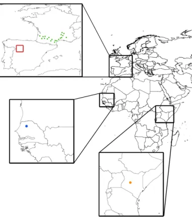
2.4 In-situ networks
All in-situ measurements used for this study were obtained via the International Soil
5
Moisture Network (Dorigo et al., 2011, 2013). The single probes/networks (Fig. 2) were selected to cover regions in which each of the three elements of the CCI NRT dataset, namely its active, passive and merged component, are used.
Accordingly, we extract measurements from the Smosmania network (Albergel et al., 2008) in the South of France to validate the active component of the daily ESA CCI
sur-10
face soil moisture updates, from the Remedhus network (Sanchez et al., 2012) in the West of Spain to validate the merged active/passive component, from the Dahra net-work in Senegal and the Cosmos netnet-work in Kenya to validate the passive component. The Smosmania (Albergel et al., 2008) and Dahra networks are equipped with the same type of probes (ThetaProbe ML2X), while the Remedhus network that covers the
15
Duero basin relies on Stevens HydraProbes. The Cosmos station in Kenya relies on a cosmic-ray probe. All in-situ observations were filtered for stations that measure the soil moisture content up to a depth of 5 cm (respectively 10 cm for the Cosmos station) to ensure the comparability with the satellite-derived surface soil moisture datasets.
3 Methods
20
HESSD
12, 11549–11589, 2015Combining satellite observations to develop a daily global soil moisture product
M. Enenkel et al.
Title Page
Abstract Introduction
Conclusions References
Tables Figures
◭ ◮
◭ ◮
Back Close
Full Screen / Esc
Printer-friendly Version
Interactive Discussion
Discussion
P
a
per
|
Discussion
P
a
per
|
Discussion
P
a
per
|
Discussion
P
a
per
|
3.1 Adaptation of the CCI soil moisture processing chain for daily updates
The extension of the ESA CCI SM processing chain is based on the method developed by Liu et al. (2011a, 2012). Figure 3 illustrates the main processing steps for the inte-gration of operational soil moisture observation in a flow chart. The entire processing chain was built in the free and open-source software Python.
5
Just like within the ESA CCI SM processing chain all ASCAT level 2 data are first masked according to frozen conditions and vegetation density. The AMSR-2 data are masked for soil skin temperature below 0◦C, RFI and vegetation optical depth (VOD). After the spatial resampling via a regular hamming window to a 0.25◦grid we apply the temporal resampling at 00:00 UTC via nearest neighbour search. In contrast to
AMSR-10
2 both ascending and descending orbits are used in case of ASCAT. Both datasets are rescaled to the reference soil moisture dataset (GLDAS NOAH Version 1.0) via linear CDF matching. Due to the unavailability of the GLDAS dataset in NRT, we apply the scaling functions that were used to generate the original ESA CCI SM dataset. This way it is possible to preserve the datasets’ original, relative dynamics, while adjusting
15
them to the same range and distribution.
Figure 4 illustrates the coverage of active, passive and merged data on a global scale. The passive LPRM soil moisture product is used in regions with lower vegeta-tion density, whereas the TU-Wien ASCAT product is applied in regions with higher vegetation density. Vegetation density is represented by vegetation optical depth, a
di-20
mensionless variable linked to the vegetation water content and above ground biomass (Liu et al., 2015). VOD has previously been used as an additional indicator for long-term vegetation dynamics (Liu et al., 2011b). It is retrieved simultaneously to soil moisture through the LPRM. So-called transition zones, areas between desert and tropical cli-mate, are characterized by VOD values between 0.24 and 0.60. In these regions the
25
HESSD
12, 11549–11589, 2015Combining satellite observations to develop a daily global soil moisture product
M. Enenkel et al.
Title Page
Abstract Introduction
Conclusions References
Tables Figures
◭ ◮
◭ ◮
Back Close
Full Screen / Esc
Printer-friendly Version
Interactive Discussion
Discussion
P
a
per
|
Discussion
P
a
per
|
Discussion
P
a
per
|
Discussion
P
a
per
|
3.2 Performance metrics and validation
According to Wagner et al. (2013) the validation of satellite data via in-situ observations can be critical due to different issues, such as the high spatio-temporal variability of soil moisture (Western et al., 2002) or a lack of adequate reference datasets (Crow et al., 2012). There are no reference data that represent exactly the same physical quantity
5
as the satellite observation. Acknowledging these limitations, this study concentrates on the following comparative assessments:
– calculating the Pearson’s correlation coefficient (R) for ESA CCI SM and CCI NRT for 2013 on a global scale;
– calculating the absolute differences in volumetric soil moisture between both
10
datasets for the entire year of 2013 (including individual calculations for all sea-sons) on a global scale;
– individual validation for ESA CCI SM and CCI NRT for 2013 over forty in-situ soil moisture observations (two networks, two single stations) in France, Kenya, Senegal and Spain.
15
For each in-situ observation a nearest neighbour search selects the closest grid point in the satellite-derived datasets. The performance metrics include:
– Pearson correlation (R), indicating a linear relationship between two variables;
– Spearman correlation (S), a non-parametric test that does not rely on any as-sumption about the distribution of the data;
20
– the absolute bias in m3m−3;
– unbiased root mean squared difference (RMSD) in m3m−3.
Equation (1) shows that the biasE is expressed as the difference between the time series’f and referencer, corresponding to the mean values of ESA CCI SM and CCI NRT.
HESSD
12, 11549–11589, 2015Combining satellite observations to develop a daily global soil moisture product
M. Enenkel et al.
Title Page
Abstract Introduction
Conclusions References
Tables Figures
◭ ◮
◭ ◮
Back Close
Full Screen / Esc
Printer-friendly Version
Interactive Discussion
Discussion
P
a
per
|
Discussion
P
a
per
|
Discussion
P
a
per
|
Discussion
P
a
per
|
E=f−r (1)
As the name suggests, the unbiased RMSD considers the overall bias related to the quadratic difference in observations (Taylor, 2001). Consequently, the unbiased RMSD E′ in Eq. (2) relates the individual bias for each time series to the corresponding ob-servation values, whereasfnandrnagain correspond to observations of ESA CCI SM
5
and CCI NRT.
E′=
(
1 N
N X
n=1 h
fn−f
− rn−r i2
)1/2
(2)
4 Results
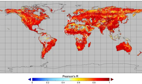
The Pearson correlation coefficient (R) yields an average correlation of 0.8 for ESA CCI SM and CCI NRT on a global scale (Fig. 5). Regions in which the NRT dataset
10
does not correspond well with the offline datasets include parts of North Africa and the Sahel, the US West coast and the Andes in South America. Tropical forests are masked, because they are impenetrable to radars at the applied frequencies and block the soil moisture emission for radiometers.
Since the good agreement of the ESA CCI SM and the CCI NRT dataset is only
15
meaningful if it represents actual surface soil moisture conditions on the ground we calculate the performance metrics for both datasets related to daily in-situ observations (Table 1). The Pearson correlation coefficient for all in-situ stations is 0.58 (ESA CCI SM), respectively 0.49 (CCI NRT). The statistical scores for the Smosmania and the Remedhus network are comparable to the findings of Albergel et al. (2012), whose
20
HESSD
12, 11549–11589, 2015Combining satellite observations to develop a daily global soil moisture product
M. Enenkel et al.
Title Page
Abstract Introduction
Conclusions References
Tables Figures
◭ ◮
◭ ◮
Back Close
Full Screen / Esc
Printer-friendly Version
Interactive Discussion
Discussion
P
a
per
|
Discussion
P
a
per
|
Discussion
P
a
per
|
Discussion
P
a
per
|
The validation results for the corresponding anomalies, which were calculated based on a moving average with a window size of 35 days, are in line with the findings (Brocca et al., 2011). Table 2 lists the Pearson correlation coefficient, which is on average lower for the anomalies than for their time series and, as expected, lower for CCI NRT than for ESA CCI SM. Again, both the bias and the unbiased RMSD are higher for CCI NRT.
5
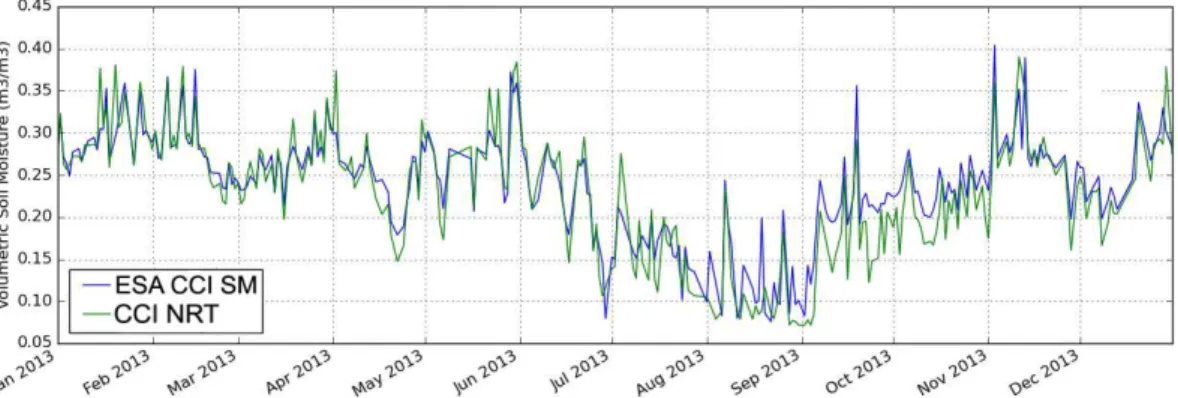
In order to understand the temporal behaviour of both datasets over the location of the validation networks we also calculate the Pearson’s/Spearman’s correlations coefficient over the location of the in-situ stations. These calculations confirm the global picture with an averageR of 0.8 and an S of 0.82. The best correlation is observed over the location of the “Urgons” station in the Smosmania network, which is located in
10
a cultivated area in the South of France (Fig. 6).
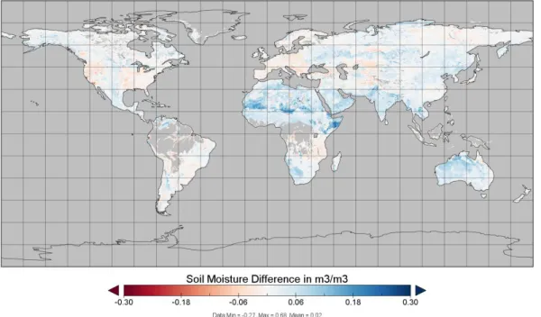
Finally, we also generate global maps that show the absolute differences of both datasets for 2013 (Fig. B1) and the four seasons (Figs. B2–B5). All maps expose a systematic overestimation in CCI NRT of up to 0.3 m3m−3 compared to ESA CCI SM in regions such as East Africa, parts of the Sahel and Pakistan, whereas the
ef-15
fect is stronger in spring and summer than in autumn and winter. In the central United States, large parts of Australia and Southern Africa this overestimation is less distinct. Since the overestimation mainly appears in regions where the AMSR-2 dataset is used (Fig. 4) and to understand the underestimation of soil moisture over Europe during winter 2013 we also analyse the absolute difference between the offline and the NRT
20
ASCAT and AMSR-2 datasets (Figs. B6 and B7). Compared to the offline product, AMSR-2 NRT tends to overestimate on a global scale, mainly in parts of the Horn of Africa, the Arabic peninsula, parts of Australia, South America and Southern Africa. The strong overestimation in the Horn of Africa is also clearly visible in the CCI NRT dataset. On the contrary, ASCAT tends to underestimate, mainly over Europe with the
25
HESSD
12, 11549–11589, 2015Combining satellite observations to develop a daily global soil moisture product
M. Enenkel et al.
Title Page
Abstract Introduction
Conclusions References
Tables Figures
◭ ◮
◭ ◮
Back Close
Full Screen / Esc
Printer-friendly Version
Interactive Discussion
Discussion
P
a
per
|
Discussion
P
a
per
|
Discussion
P
a
per
|
Discussion
P
a
per
|
5 Discussion and conclusions
The global daily update of the ESA CCI SM surface soil moisture dataset is moti-vated by uncertainties in the performance of operational radars/radiometers (in our case ASCAT and AMSR-2) and by an increasing interest in remotely sensed soil mois-ture across a wide range of applications. The need for improved and more timely soil
5
moisture representations in agricultural drought monitoring is one of the strongest mo-tivations (Anderson et al., 2012; Bolten and Crow, 2012; Enenkel et al., 2014; Hirschi et al., 2014). The CCI NRT dataset was generated by adapting the ESA CCI SM pro-cessing chain for operational NRT soil moisture retrievals. Just like in the offline product the merging scheme considers each sensor’s individual strengths and limitations.
AS-10
CAT, for instance, performs better than AMSR-2 at higher vegetation densities, while one strength of AMSR-2 is the retrieval over semi-arid and arid regions (Liu et al., 2011a). A first validation is carried out, looking at the correlation of ESA CCI SM and the new CCI NRT dataset on a global scale and their agreement over selected in-situ stations. In addition, we calculate the absolute differences between both datasets on
15
a global scale. With regard to the validation via two in-situ observation networks and two single stations we present the performance metrics for ESA CCI SM and CCI NRT and their anomalies.
Our main findings are:
– The new CCI NRT dataset corresponds well (average R=0.8) with to the
of-20
fline ESA CCI SM dataset on a global scale for the entire year of 2013, indi-cating a good performance of NRT soil moisture observations from ASCAT and AMSR-2. Low correlations are for instance observed in the arid zones of Northern Africa. One possible explanation is that the GLDAS-based rescaling parameters that were calculated for the AMSR-2 product in ESA CCI SM are not suitable for
25
HESSD
12, 11549–11589, 2015Combining satellite observations to develop a daily global soil moisture product
M. Enenkel et al.
Title Page
Abstract Introduction
Conclusions References
Tables Figures
◭ ◮
◭ ◮
Back Close
Full Screen / Esc
Printer-friendly Version
Interactive Discussion
Discussion
P
a
per
|
Discussion
P
a
per
|
Discussion
P
a
per
|
Discussion
P
a
per
|
– The validation with in-situ observations in Spain, France, Senegal and Kenya yields lower results for the CCI NRT dataset. The average Pearson correlation coefficient (R) for all in-situ stations is 0.49 (0.58 for ESA CCI SM). The unbiased RMSD for CCI NRT is 0.008 (0.004 for ESA CCI SM). We observe hardly any difference in the overall bias (0.05 m3m−3for both datasets).
5
– The performance metrics for the corresponding anomalies result in an average correlation coefficient (Pearson) of 0.44 for ESA CCI SM and 0.38 for CCI NRT, respectively.
– A comparison of ESA CCI SM and CCI NRT for 2013 reveals an underestimation of CCI NRT over Europe (particularly during Winter 2013) and an overestimation
10
over several dry areas (particularly in Africa and Australia). In order to under-stand these biases better we calculated the absolute differences between the corresponding offline and online products of ASCAT and AMSR-2. These calcu-lations confirm the underestimation of the ASCAT NRT product over Europe or the United States (Fig. B6). Although ASCAT NRT tends to over- and
underesti-15
mate the overall agreement between the offline and online product is satisfying. In case of AMSR-2 (Fig. B7), the systematic overestimation on a global scale, for instance in the Horn of Africa, could be caused by intercalibration issues. In addition to known intercalibration issues between AMSR-2 and its predecessor AMSR-E (Okuyama and Imaoka, 2015) there might be additional issues related
20
to the different operational versions of the AMSR-2 dataset. Nevertheless, also here the general agreement between the passive components in ESA CCI SM and CCI NRT is good.
We expect that, apart from solving the AMSR-2 intercalibration issues and a dy-namic snow map for ASCAT, two improvements in the processing chain could lead to
25
HESSD
12, 11549–11589, 2015Combining satellite observations to develop a daily global soil moisture product
M. Enenkel et al.
Title Page
Abstract Introduction
Conclusions References
Tables Figures
◭ ◮
◭ ◮
Back Close
Full Screen / Esc
Printer-friendly Version
Interactive Discussion
Discussion
P
a
per
|
Discussion
P
a
per
|
Discussion
P
a
per
|
Discussion
P
a
per
|
and the NRT ASCAT product differ in their absolute calibration level affecting the soil moisture values. An update of the model parameters for the ASCAT NRT product at EUMETSAT is planned for 2015. In this study we apply the rescaling parameters that had been developed for the offline ASCAT product to ASCAT NRT. Despite the good correlation between both products it is likely that their consistency can be improved by
5
reprocessing the rescaling parameters in the CCI NRT processing chain. Second, the currently static RFI map for AMSR-2 could be replaced by a dynamic map that is based on the average RFI values for the previous six months via a moving average. In a recent study (de Nijs et al., 2015), an improved algorithm to detect RFI at the global scale for 6.9 and 7.3 GHz AMSR2 observations was proposed, but remains to be tested. This
10
is the first method that takes the additional 7.3 GHz channel into account, which was specifically added to the AMSR-E sensor concept to improve retrieval issues related to RFI.
Despite these issues, a processing chain that allows daily soil moisture updates is promising in the face of a new generation of soil moisture missions such as
Sentinel-15
1 of the ESA and the European Commission (EC) or NASA’s SMAP (Soil Moisture Active/Passive). These new sensors are able to retrieve soil moisture at a far higher resolution than ASCAT or AMSR-2 – around one kilometre for operational products and below 100 m for research products. Of course the higher spatial resolution has a drawback, which is a decrease in temporal resolution. While ASCAT on
MetOp-20
A alone covers more than 80 % of the globe every day, the two Sentinel-1 satellites will take 6–12 days to scan the total global land mass in the default interferometric wide swath (IWS) mode (World Meteorological Organization, 2013). Despite the diff er-ences in spatial resolution it is possible to increase the temporal resolution of the CCI NRT dataset to fit various applications. One example is numerical weather prediction,
25
HESSD
12, 11549–11589, 2015Combining satellite observations to develop a daily global soil moisture product
M. Enenkel et al.
Title Page
Abstract Introduction
Conclusions References
Tables Figures
◭ ◮
◭ ◮
Back Close
Full Screen / Esc
Printer-friendly Version
Interactive Discussion
Discussion
P
a
per
|
Discussion
P
a
per
|
Discussion
P
a
per
|
Discussion
P
a
per
|
In the face of the upcoming generation of space-based soil moisture sensors it seems to be the most promising approach to exploit each sensor’s individual strength to generate the most accurate and complete soil moisture dataset. This way, it will be possible to support decision-makers in various domains with global soil moisture ob-servations. However, developing a user-friendly dataset means more than data access.
5
As a consequence, software packages, such as Python Open Earth Observation Tools (Mistelbauer et al., 2014) are necessary to enable automated updates, the visualization of images/time series/anomalies and the analysis of critical soil moisture thresholds.
Author contributions. Enenkel, M.: Lead author, algorithmic adaptation/implementation of the processing chain, validation. Reimer, C.: algorithmic adaptation of the processing chain. Dorigo,
10
W.: algorithmic adaptation of the processing chain, link to ESA CCI SM. Wagner, W.: overall manuscript structure, state-of-the-art. Pfeil, W.: algorithmic implementation of the processing chain, merging. Parinussa, R.: issues related to radiometric observations, RFI. De Jeu, R.: issues related to radiometric observations.
Acknowledgements. This research was supported and funded within the framework of SATIDA
15
HESSD
12, 11549–11589, 2015Combining satellite observations to develop a daily global soil moisture product
M. Enenkel et al.
Title Page
Abstract Introduction
Conclusions References
Tables Figures
◭ ◮
◭ ◮
Back Close
Full Screen / Esc
Printer-friendly Version
Interactive Discussion
Discussion
P
a
per
|
Discussion
P
a
per
|
Discussion
P
a
per
|
Discussion
P
a
per
|
References
Albergel, C., Rüdiger, C., Pellarin, T., Calvet, J.-C., Fritz, N., Froissard, F., Suquia, D., Petitpa, A., Piguet, B., and Martin, E.: From near-surface to root-zone soil moisture using an exponential filter: an assessment of the method based on in-situ observations and model simulations, Hydrol. Earth Syst. Sci., 12, 1323–1337, doi:10.5194/hess-12-1323-2008, 2008.
5
Albergel, C., de Rosnay, P., Gruhier, C., Muñoz-Sabater, J., Hasenauer, S., Isaksen, L., Kerr, Y., and Wagner, W.: Evaluation of remotely sensed and modelled soil moisture prod-ucts using global ground-based in situ observations, Remote Sens. Environ., 118, 215–226, doi:10.1016/j.rse.2011.11.017, 2012.
Al-Yaari, A., Wigneron, J.-P., Ducharne, A., Kerr, Y. H., Wagner, W., De Lannoy, G.,
Re-10
ichle, R., Al Bitar, A., Dorigo, W., Richaume, P., and Mialon, A.: Global-scale compari-son of passive (SMOS) and active (ASCAT) satellite based microwave soil moisture re-trievals with soil moisture simulations (MERRA-Land), Remote Sens. Environ., 152, 614– 626, doi:10.1016/j.rse.2014.07.013, 2014.
Anderson, W. B., Zaitchik, B. F., Hain, C. R., Anderson, M. C., Yilmaz, M. T., Mecikalski, J.,
15
and Schultz, L.: Towards an integrated soil moisture drought monitor for East Africa, Hydrol. Earth Syst. Sci., 16, 2893–2913, doi:10.5194/hess-16-2893-2012, 2012.
Barichivich, J., Briffa, K. R., Myneni, R., Schrier, G. van der, Dorigo, W., Tucker, C. J., Os-born, T. J., and Melvin, T. M.: Temperature and snow-mediated moisture controls of summer photosynthetic activity in northern terrestrial ecosystems between 1982 and 2011, Remote
20
Sensing, 6, 1390–1431, doi:10.3390/rs6021390, 2014.
Bartalis, Z., Scipal, K., and Wagner, W.: Soil moisture products from C-band scatterome-ters: from Ers-1/2 to Metop, in: Proceedings of the 2004 ENVISAT & ERS Symposium, 6– 10 September 2004, Salzburg, Austria, ESA SP-572, European Space Agency, Noordwijk, the Netherlands, 2005.
25
Bauer-Marschallinger, B., Dorigo, W. A., Wagner, W., and van Dijk, A. I. J. M.: How oceanic oscillation drives soil moisture variations over Mainland Australia: an analysis of 32 years of satellite observations, J. Climate, 26, 10159–10173, doi:10.1175/JCLI-D-13-00149.1, 2013. Bolten, J. D. and Crow, W. T.: Improved prediction of quasi-global vegetation
condi-tions using remotely-sensed surface soil moisture, Geophys. Res. Lett., 39, L19406,
30
HESSD
12, 11549–11589, 2015Combining satellite observations to develop a daily global soil moisture product
M. Enenkel et al.
Title Page
Abstract Introduction
Conclusions References
Tables Figures
◭ ◮
◭ ◮
Back Close
Full Screen / Esc
Printer-friendly Version
Interactive Discussion
Discussion
P
a
per
|
Discussion
P
a
per
|
Discussion
P
a
per
|
Discussion
P
a
per
|
Brocca, L., Melone, F., Moramarco, T., and Morbidelli, R.: Soil moisture tempo-ral stability over experimental areas in Centtempo-ral Italy, Geoderma, 148, 364–374, doi:10.1016/j.geoderma.2008.11.004, 2009.
Brocca, L., Melone, F., Moramarco, T., Wagner, W., Naeimi, V., Bartalis, Z., and Hasenauer, S.: Improving runoff prediction through the assimilation of the ASCAT soil moisture product,
5
Hydrol. Earth Syst. Sci., 14, 1881–1893, doi:10.5194/hess-14-1881-2010, 2010.
Brocca, L., Hasenauer, S., Lacava, T., Melone, F., Moramarco, T., Wagner, W., Dorigo, W., Matgen, P., Martínez-Fernández, J., Llorens, P., Latron, J., Martin, C., and Bit-telli, M.: Soil moisture estimation through ASCAT and AMSR-E sensors: an intercom-parison and validation study across Europe, Remote Sens. Environ., 115, 3390–3408,
10
doi:10.1016/j.rse.2011.08.003, 2011.
Crow, W. T., Berg, A. A., Cosh, M. H., Loew, A., Mohanty, B. P., Panciera, R., de Rosnay, P., Ryu, D., and Walker, J. P.: Upscaling sparse ground-based soil moisture observations for the validation of coarse-resolution satellite soil moisture products, Rev. Geophys., 50, RG2002, doi:10.1029/2011RG000372, 2012.
15
Dee, D. P., Uppala, S. M., Simmons, A. J., Berrisford, P., Poli, P., Kobayashi, S., Andrae, U., Balmaseda, M. A., Balsamo, G., Bauer, P., Bechtold, P., Beljaars, A. C. M., van de Berg, L., Bidlot, J., Bormann, N., Delsol, C., Dragani, R., Fuentes, M., Geer, A. J., Haimberger, L., Healy, S. B., Hersbach, H., Hólm, E. V., Isaksen, L., Kållberg, P., Köhler, M., Matricardi, M., McNally, A. P., Monge-Sanz, B. M., Morcrette, J.-J., Park, B.-K., Peubey, C., de Rosnay, P.,
20
Tavolato, C., Thépaut, J.-N., and Vitart, F.: The ERA-Interim reanalysis: configuration and performance of the data assimilation system, Q. J. Roy. Meteorol. Soc., 137, 553–597, doi:10.1002/qj.828, 2011.
de Jeu, R. A. M., Holmes, T. R. H., Parinussa, R. M., and Owe, M.: A spatially coherent global soil moisture product with improved temporal resolution, J. Hydrol., 516, 284–296,
25
doi:10.1016/j.jhydrol.2014.02.015, 2014.
de Nijs, A. H. A., Parinussa, R. M., de Jeu, R. A. M., Schellekens, J., and Holmes, T. R. H.: A methodology to determine radio-frequency interference in AMSR2 observations, IEEE T. Geosci. Remote, 53, 5148–5159, doi:10.1109/TGRS.2015.2417653, 2015.
Dorigo, W. A., Wagner, W., Hohensinn, R., Hahn, S., Paulik, C., Drusch, M., Mecklenburg, S.,
30
HESSD
12, 11549–11589, 2015Combining satellite observations to develop a daily global soil moisture product
M. Enenkel et al.
Title Page
Abstract Introduction
Conclusions References
Tables Figures
◭ ◮
◭ ◮
Back Close
Full Screen / Esc
Printer-friendly Version
Interactive Discussion
Discussion
P
a
per
|
Discussion
P
a
per
|
Discussion
P
a
per
|
Discussion
P
a
per
|
Dorigo, W. A., de Jeu, R., Chung, D., Parinussa, R., Liu, Y., Wagner, W., and Fernández-Prieto, D.: Evaluating global trends (1988–2010) in harmonized multi-satellite surface soil moisture, Geophys. Res. Lett., 39, L18405, doi:10.1029/2012GL052988, 2012.
Dorigo, W. A., Xaver, A., Vreugdenhil, M., Gruber, A., Hegyiová, A., Sanchis-Dufau, A. D., Zamojski, D., Cordes, C., Wagner, W., and Drusch, M.: Global automated quality control
5
of in situ soil moisture data from the international soil moisture network, Vadose Zone J., 12, doi:10.2136/vzj2012.0097, 2013.
Drusch, M., Scipal, K., de Rosnay, P., Balsamo, G., Andersson, E., Bougeault, P., and Viterbo, P.: Towards a Kalman Filter based soil moisture analysis system for the operational ECMWF Integrated Forecast System, Geophys. Res. Lett., 36, L10401,
10
doi:10.1029/2009GL037716, 2009.
Enenkel, M., See, L., Bonifacio, R., Boken, V., Chaney, N., Vinck, P., You, L., Dutra, E., and Anderson, M.: Drought and food security – improving decision-support via new technologies and innovative collaboration, Global Food Secur., 4, 51–55, doi:10.1016/j.gfs.2014.08.005, 2014.
15
Gleick, P. H. and White, G. F. (Eds.): Water in Crisis: a Guide to the World’s Fresh-Water Re-sources, Oxford University Press, New York, 1993.
Greve, P., Orlowsky, B., Mueller, B., Sheffield, J., Reichstein, M., and Seneviratne, S. I.: Global assessment of trends in wetting and drying over land, Nat. Geosci., 7, 716–721, doi:10.1038/ngeo2247, 2014.
20
Group on Earth Observations: Critical Earth Observation Priorities (Second Edition), avail-able at: http://sbageotask.larc.nasa.gov/Final_SBA_Report_US0901a_v2.pdf (last access: 28 January 2015), 2012.
Gruhier, C., de Rosnay, P., Hasenauer, S., Holmes, T., de Jeu, R., Kerr, Y., Mougin, E., Njoku, E., Timouk, F., Wagner, W., and Zribi, M.: Soil moisture active and passive microwave products:
25
intercomparison and evaluation over a Sahelian site, Hydrol. Earth Syst. Sci., 14, 141–156, doi:10.5194/hess-14-141-2010, 2010.
Hirschi, M., Mueller, B., Dorigo, W., and Seneviratne, S. I.: Using remotely sensed soil moisture for land–atmosphere coupling diagnostics: the role of surface vs. root-zone soil moisture variability, Remote Sens. Environ., 154, 246–252, doi:10.1016/j.rse.2014.08.030, 2014.
30
HESSD
12, 11549–11589, 2015Combining satellite observations to develop a daily global soil moisture product
M. Enenkel et al.
Title Page
Abstract Introduction
Conclusions References
Tables Figures
◭ ◮
◭ ◮
Back Close
Full Screen / Esc
Printer-friendly Version
Interactive Discussion
Discussion
P
a
per
|
Discussion
P
a
per
|
Discussion
P
a
per
|
Discussion
P
a
per
|
Jung, M., Reichstein, M., Ciais, P., Seneviratne, S. I., Sheffield, J., Goulden, M. L., Bonan, G., Cescatti, A., Chen, J., de Jeu, R., Dolman, A. J., Eugster, W., Gerten, D., Gianelle, D., Gobron, N., Heinke, J., Kimball, J., Law, B. E., Montagnani, L., Mu, Q., Mueller, B., Ole-son, K., Papale, D., RichardOle-son, A. D., Roupsard, O., Running, S., Tomelleri, E., Viovy, N., Weber, U., Williams, C., Wood, E., Zaehle, S., and Zhang, K.: Recent decline in the
5
global land evapotranspiration trend due to limited moisture supply, Nature, 467, 951–954, doi:10.1038/nature09396, 2010.
Koster, R. D., Guo, Z., Bonan, G., Chan, E., Cox, P., Gordon, C. T., Kanae, S., Kowalczyk, E., Lawrence, D., Liu, P., Lu, C.-H., Malyshev, S., McAvaney, B., Mitchell, K., Mocko, D., Oki, T., Oleson, K., Pitman, A., Sud, Y. C., Taylor, C. M., Verseghy, D., Vasic, R., Xue, Y., and
10
Yamada, T.: Regions of Strong Coupling Between Soil Moisture and Precipitation, Science, 305, 1138–1140, doi:10.1126/science.1100217, 2004.
Legates, D. R., Mahmood, R., Levia, D. F., DeLiberty, T. L., Quiring, S. M., Houser, C., and Nelson, F. E.: Soil moisture: a central and unifying theme in physical geography, Prog. Phys. Geogr., 35, 65–86, doi:10.1177/0309133310386514, 2010.
15
Liu, Y. Y., van Dijk, A. I. J. M., de Jeu, R. A. M., and Holmes, T. R. H.: An analysis of spatiotem-poral variations of soil and vegetation moisture from a 29-year satellite-derived data set over mainland Australia, Water Resour. Res., 45, W07405, doi:10.1029/2008WR007187, 2009. Liu, Y. Y., Parinussa, R. M., Dorigo, W. A., De Jeu, R. A. M., Wagner, W., van Dijk, A. I. J. M.,
McCabe, M. F., and Evans, J. P.: Developing an improved soil moisture dataset by blending
20
passive and active microwave satellite-based retrievals, Hydrol. Earth Syst. Sci., 15, 425– 436, doi:10.5194/hess-15-425-2011, 2011a.
Liu, Y. Y., de Jeu, R. A. M., McCabe, M. F., Evans, J. P., and van Dijk, A. I. J. M.: Global long-term passive microwave satellite-based retrievals of vegetation optical depth, Geophys. Res. Lett., 38, L18402, doi:10.1029/2011GL048684, 2011b.
25
Liu, Y. Y., Dorigo, W. A., Parinussa, R. M., de Jeu, R. A. M., Wagner, W., Mc-Cabe, M. F., Evans, J. P., and van Dijk, A. I. J. M.: Trend-preserving blending of pas-sive and active microwave soil moisture retrievals, Remote Sens. Environ., 123, 280–297, doi:10.1016/j.rse.2012.03.014, 2012.
Liu, Y. Y., van Dijk, A. I. J. M., de Jeu, R. A. M., Canadell, J. G., McCabe, M. F., Evans, J. P.,
30
HESSD
12, 11549–11589, 2015Combining satellite observations to develop a daily global soil moisture product
M. Enenkel et al.
Title Page
Abstract Introduction
Conclusions References
Tables Figures
◭ ◮
◭ ◮
Back Close
Full Screen / Esc
Printer-friendly Version
Interactive Discussion
Discussion
P
a
per
|
Discussion
P
a
per
|
Discussion
P
a
per
|
Discussion
P
a
per
|
McNally, A., Husak, G. J., Brown, M., Carroll, M., Funk, C., Yatheendradas, S., Arsenault, K., Peters-Lidard, C., and Verdin, J. P.: Calculating crop water requirement satisfaction in the West Africa Sahel with remotely sensed soil moisture, J. Hydrometeorol., 16, 295–305, doi:10.1175/JHM-D-14-0049.1, 2015.
Mistelbauer, T., Enenkel, M., and Wagner, W.: POETS – Python Earth Observation Tools,
5
Poster: GIScience 2014, Vienna, 2014-09-23, in: “Extended Abstract Proceedings of the GIScience 2014”, GeoInfo Series 40, 2014.
Muñoz, A. A., Barichivich, J., Christie, D. A., Dorigo, W., Sauchyn, D., González-Reyes, Á., Villalba, R., Lara, A., Riquelme, N., and González, M. E.: Patterns and drivers of Arau-caria araucana forest growth along a biophysical gradient in the northern Patagonian Andes:
10
linking tree rings with satellite observations of soil moisture, Austral. Ecol., 39, 158–169, doi:10.1111/aec.12054, 2014.
Nicolai-Shaw, N., Hirschi, M., Mittelbach, H., and Seneviratne, S. I.: Spatial representativeness of soil moisture using in situ, remote sensing, and land reanalysis data, J. Geophys. Res.-Atmos., doi:10.1002/2015JD023305, in press, 2015.
15
Njoku, E. G. and Li, L.: Retrieval of land surface parameters using passive microwave measure-ments at 6–18 GHz, IEEE T. Geosci. Remote, 37, 79–93, doi:10.1109/36.739125, 1999. Okuyama, A. and Imaoka, K.: Intercalibration of Advanced Microwave Scanning
Radiometer-2 (AMSRRadiometer-2) brightness temperature, IEEE T. Geosci. Remote, 53, 4568–4577, doi:10.1109/TGRS.2015.2402204, 2015.
20
Oliva, R., Daganzo, E., Kerr, Y. H., Mecklenburg, S., Nieto, S., Richaume, P., and Gruhier, C.: SMOS radio frequency interference scenario: status and actions taken to improve the RFI environment in the 1400–1427-MHz passive band, IEEE T. Geosci. Remote, 50, 1427–1439, doi:10.1109/TGRS.2012.2182775, 2012.
Owe, M., de Jeu, R., and Holmes, T.: Multisensor historical climatology of
satellite-25
derived global land surface moisture, J. Geophys. Res.-Earth, 113, F01002, doi:10.1029/2007JF000769, 2008.
Qiu, J., Crow, W. T., Nearing, G. S., Mo, X., and Liu, S.: The impact of vertical measurement depth on the information content of soil moisture times series data, Geophys. Res. Lett., 41, 4997–5004, doi:10.1002/2014GL060017, 2014.
30
HESSD
12, 11549–11589, 2015Combining satellite observations to develop a daily global soil moisture product
M. Enenkel et al.
Title Page
Abstract Introduction
Conclusions References
Tables Figures
◭ ◮
◭ ◮
Back Close
Full Screen / Esc
Printer-friendly Version
Interactive Discussion
Discussion
P
a
per
|
Discussion
P
a
per
|
Discussion
P
a
per
|
Discussion
P
a
per
|
Rodell, M., Houser, P. R., Jambor, U., Gottschalck, J., Mitchell, K., Meng, C.-J., Arsenault, K., Cosgrove, B., Radakovich, J., Bosilovich, M., Entin, J. K., Walker, J. P., Lohmann, D., and Toll, D.: The Global Land Data Assimilation System, B. Am. Meteorol. Soc., 85, 381–394, doi:10.1175/BAMS-85-3-381, 2004.
Rüdiger, C., Calvet, J.-C., Gruhier, C., Holmes, T. R. H., de Jeu, R. A. M., and Wagner, W.: An
in-5
tercomparison of ERS-Scat and AMSR-E soil moisture observations with model simulations over France, J. Hydrometeorol., 10, 431–447, doi:10.1175/2008JHM997.1, 2009.
Sanchez, N., Martinez-Fernandez, J., Scaini, A., and Perez-Gutierrez, C.: Validation of the SMOS L2 soil moisture data in the REMEDHUS Network (Spain), IEEE T. Geosci. Remote, 50, 1602–1611, doi:10.1109/TGRS.2012.2186971, 2012.
10
Schmugge, T. and Jackson, T. J.: Mapping surface soil moisture with microwave radiometers, Meteorol. Atmos. Phys., 54, 213–223, doi:10.1007/BF01030061, 1994.
Scipal, K., Drusch, M., and Wagner, W.: Assimilation of a ERS scatterometer derived soil mois-ture index in the ECMWF numerical weather prediction system, Adv. Water Resour., 31, 1101–1112, doi:10.1016/j.advwatres.2008.04.013, 2008.
15
Seneviratne, S. I., Corti, T., Davin, E. L., Hirschi, M., Jaeger, E. B., Lehner, I., Orlowsky, B., and Teuling, A. J.: Investigating soil moisture–climate interactions in a changing climate: a review, Earth-Sci. Rev., 99, 125–161, doi:10.1016/j.earscirev.2010.02.004, 2010.
Sheffield, J. and Wood, E. F.: Global trends and variability in soil moisture and drought char-acteristics, 1950–2000, from observation-driven simulations of the terrestrial hydrologic
cy-20
cle, J. Climate, 21, 432–458, doi:10.1175/2007JCLI1822.1, 2008.
Taylor, C. M., de Jeu, R. A. M., Guichard, F., Harris, P. P., and Dorigo, W. A.: Afternoon rain more likely over drier soils, Nature, 489, 423–426, doi:10.1038/nature11377, 2012.
Taylor, K. E.: Summarizing multiple aspects of model performance in a single diagram, J. Geo-phys. Res.-Atmos., 106, 7183–7192, doi:10.1029/2000JD900719, 2001.
25
Trenberth, K. E., Dai, A., van der Schrier, G., Jones, P. D., Barichivich, J., Briffa, K. R., and Sheffield, J.: Global warming and changes in drought, Nat. Clim. Change, 4, 17–22, doi:10.1038/nclimate2067, 2014.
Vachaud, G., Passerat De Silans, A., Balabanis, P., and Vauclin, M.: Temporal stability of spa-tially measured soil water probability density function, Soil Sci. Soc. Am. J., 49, 822–828,
30
HESSD
12, 11549–11589, 2015Combining satellite observations to develop a daily global soil moisture product
M. Enenkel et al.
Title Page
Abstract Introduction
Conclusions References
Tables Figures
◭ ◮
◭ ◮
Back Close
Full Screen / Esc
Printer-friendly Version
Interactive Discussion
Discussion
P
a
per
|
Discussion
P
a
per
|
Discussion
P
a
per
|
Discussion
P
a
per
|
Wagner, W., Lemoine, G., and Rott, H.: A method for estimating soil moisture from ERS scatterometer and soil data, Remote Sens. Environ., 70, 191–207, doi:10.1016/S0034-4257(99)00036-X, 1999.
Wagner, W., Scipal, K., Pathe, C., Gerten, D., Lucht, W., and Rudolf, B.: Evaluation of the agree-ment between the first global remotely sensed soil moisture data with model and precipitation
5
data, J. Geophys. Res.-Atmos., 108, 4611, doi:10.1029/2003JD003663, 2003.
Wagner, W., Blöschl, G., Pampaloni, P., Calvet, J. C., Bizzarri, B., Wigneron, J. P., and Kerr, Y.: Operational readiness of microwave remote sensing of soil moisture for hydrologic applica-tions, Nord. Hydrol., 38, 1–20, 2007.
Wagner, W., Dorigo, W., de Jeu, R., Fernandez, D., Benveniste, J., Haas, E., and Ertl, M.:
10
Fusion of active and passive microwave observations to create an essential climate variable data record on soil moisture, ISPRS Ann. Photogramm. Remote Sens. Spat. Inf. Sci., I-7, 315–321, doi:10.5194/isprsannals-I-7-315-2012, 2012.
Wagner, W., Hahn, S., Kidd, R., Melzer, T., Bartalis, Z., Hasenauer, S., Figa-Saldaña, J., de Rosnay, P., Jann, A., Schneider, S., Komma, J., Kubu, G., Brugger, K., Aubrecht, C.,
15
Züger, J., Gangkofner, U., Kienberger, S., Brocca, L., Wang, Y., Blöschl, G., Eitzinger, J., Steinnocher, K., Zeil, P., and Rubel, F.: The ASCAT soil moisture product: a review of its specifications, validation results, and emerging applications, Meteorol. Z., 22, 5–33, doi:10.1127/0941-2948/2013/0399, 2013.
Wang, J. R. and Schmugge, T. J.: An empirical model for the complex dielectric
permittiv-20
ity of soils as a function of water content, IEEE T. Geosci. Remote, GE-18, 288–295, doi:10.1109/TGRS.1980.350304, 1980.
Western, A. W., Grayson, R. B., and Blöschl, G.: Scaling of soil moisture: a hydrologic perspec-tive, Annu. Rev. Earth Pl. Sc., 30, 149–180, doi:10.1146/annurev.earth.30.091201.140434, 2002.
25
Western, A. W., Zhou, S.-L., Grayson, R. B., McMahon, T. A., Blöschl, G., and Wilson, D. J.: Spatial correlation of soil moisture in small catchments and its relationship to dominant spatial hydrological processes, J. Hydrol., 286, 113–134, doi:10.1016/j.jhydrol.2003.09.014, 2004.
World Meteorological Organization: Future Climate Change Research and
Observa-30
HESSD
12, 11549–11589, 2015Combining satellite observations to develop a daily global soil moisture product
M. Enenkel et al.
Title Page
Abstract Introduction
Conclusions References
Tables Figures
◭ ◮
◭ ◮
Back Close
Full Screen / Esc
Printer-friendly Version
Interactive Discussion
Discussion
P
a
per
|
Discussion
P
a
per
|
Discussion
P
a
per
|
Discussion
P
a
per
|
World Meteorological Organization: Sentinel High Level Operations Plan (HLOP), avail-able at: https://www.wmo.int/pages/prog/sat/meetings/documents/PSTG-3_Doc_08-04-02_ Sentinel-HLOP.pdf (last access: 17 July 2015), 2013.
Yuan, X., Ma, Z., Pan, M., and Shi, C.: Microwave remote sensing of short-term droughts during crop growing seasons, Geophys. Res. Lett., 42, 4394–4401, doi:10.1002/2015GL064125,
5
HESSD
12, 11549–11589, 2015Combining satellite observations to develop a daily global soil moisture product
M. Enenkel et al.
Title Page
Abstract Introduction
Conclusions References
Tables Figures
◭ ◮
◭ ◮
Back Close
Full Screen / Esc
Printer-friendly Version
Interactive Discussion
Discussion
P
a
per
|
Discussion
P
a
per
|
Discussion
P
a
per
|
Discussion
P
a
per
|
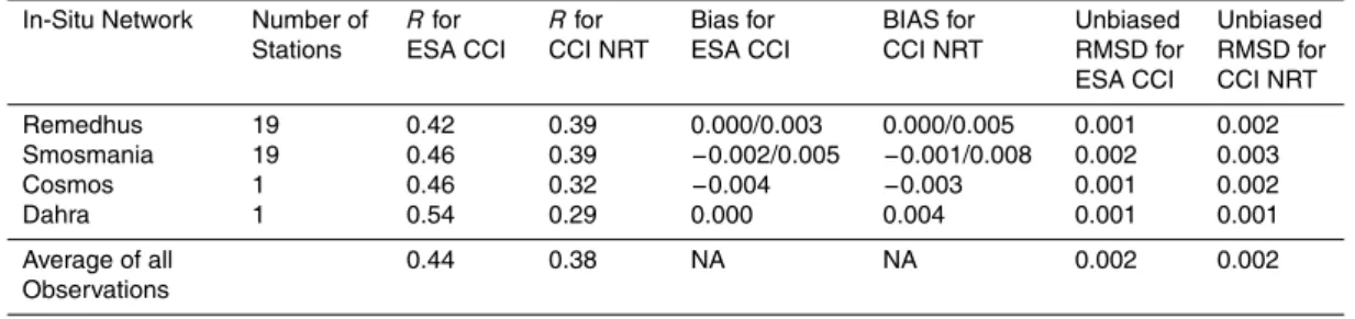
Table 1.Statistical scores for ESA CCI SM/CCI NRT and in-situ stations/networks (maximum depth 0.1 m) in Spain, France, Kenya and Senegal for 2013 (for the Remedhus and Smosmania networks the table includes the bias range from minimum to maximum).
In-Situ Network Number of Stations
Rfor ESA CCI
Rfor CCI NRT
Bias for ESA CCI
BIAS for CCI NRT
Unbiased RMSD for ESA CCI
Unbiased RMSD for CCI NRT
Remedhus 19 0.60 0.52 −0.079/0.214 −0.075/0.207 0.002 0.003
Smosmania 19 0.54 0.46 −0.129/0.170 −0.135/0.147 0.006 0.012
Cosmos 1 0.66 0.59 0.040 0.028 0.002 0.003
Dahra 1 0.65 0.61 0.128 0.155 0.003 0.003
Average of all Observations
HESSD
12, 11549–11589, 2015Combining satellite observations to develop a daily global soil moisture product
M. Enenkel et al.
Title Page
Abstract Introduction
Conclusions References
Tables Figures
◭ ◮
◭ ◮
Back Close
Full Screen / Esc
Printer-friendly Version
Interactive Discussion
Discussion
P
a
per
|
Discussion
P
a
per
|
Discussion
P
a
per
|
Discussion
P
a
per
|
Table 2.Statistical scores for ESA CCI SM/CCI NRT anomalies and in-situ stations/networks (maximum depth 0.1 m) in Spain, France, Kenya and Senegal for 2013 (for the Remedhus and Smosmania networks the table includes the bias range from minimum to maximum).
In-Situ Network Number of Stations
Rfor ESA CCI
Rfor CCI NRT
Bias for ESA CCI
BIAS for CCI NRT
Unbiased RMSD for ESA CCI
Unbiased RMSD for CCI NRT
Remedhus 19 0.42 0.39 0.000/0.003 0.000/0.005 0.001 0.002
Smosmania 19 0.46 0.39 −0.002/0.005 −0.001/0.008 0.002 0.003
Cosmos 1 0.46 0.32 −0.004 −0.003 0.001 0.002
Dahra 1 0.54 0.29 0.000 0.004 0.001 0.001
Average of all Observations
HESSD
12, 11549–11589, 2015Combining satellite observations to develop a daily global soil moisture product
M. Enenkel et al.
Title Page
Abstract Introduction
Conclusions References
Tables Figures
◭ ◮
◭ ◮
Back Close
Full Screen / Esc
Printer-friendly Version
Interactive Discussion
Discussion
P
a
per
|
Discussion
P
a
per
|
Discussion
P
a
per
|
Discussion
P
a
per
|