www.atmos-chem-phys.net/9/2241/2009/ © Author(s) 2009. This work is distributed under the Creative Commons Attribution 3.0 License.
Chemistry
and Physics
All weather IASI single field-of-view retrievals: case study –
validation with JAIVEx data
D. K. Zhou1, W. L. Smith2,3, A. M. Larar1, X. Liu1, J. P. Taylor4, P. Schl ¨ussel5, L. L. Strow6, and S. A. Mango7 1NASA Langley Research Center, Hampton, VA, USA
2Hampton University, Hampton, VA, USA
3University of Wisconsin-Madison, Madison, WI, USA 4Met Office, Exeter, Devon, UK
5EUMETSAT, Darmstadt, Germany
6University of Maryland Baltimore County, Baltimore, MD, USA 7NPOESS Integrated Program Office, Silver Spring, MD, USA
Received: 7 October 2008 – Published in Atmos. Chem. Phys. Discuss.: 16 December 2008 Revised: 17 February 2009 – Accepted: 16 March 2009 – Published: 27 March 2009
Abstract. Atmospheric thermodynamic parameters, such as atmospheric temperature and moisture profiles, cloud opti-cal/microphysical properties, and surface properties are ba-sic meteorological variables for weather forecasting. In ad-dition, they are critical parameters in tropospheric chem-istry studies. A physical, geophysical parameter retrieval scheme dealing with cloudy and cloud-free radiances ob-served with satellite ultraspectral infrared sounders has been developed to determine simultaneously surface, atmospheric thermodynamic, and cloud microphysical parameters. A one-dimensional variational (1-D Var.) multivariable inverse solution of the radiative transfer equation is used to itera-tively improve a background state defined by eigenvector re-gression. This algorithm has been applied to data from the Infrared Atmospheric Sounding Interferometer (IASI) on the EUMETSAT Metop-A satellite. The IASI retrieved parame-ters presented herein are from radiance data gathered during the Joint Airborne IASI Validation Experiment (JAIVEx). JAIVEx provided intensive aircraft observations obtained from airborne Fourier Transform Spectrometer (FTS) sys-tems, such as the NPOESS Airborne Sounder Testbed – In-terferometer (NAST-I), in-situ measurements, and dedicated dropsonde and radiosonde measurements for the validation of the IASI products. Here, IASI atmospheric profile re-trievals are compared with those obtained from dedicated dropsondes, radiosondes, and the airborne FTS system. The
Correspondence to:D. K. Zhou ([email protected])
IASI examples presented here demonstrate the ability to re-trieve fine-scale horizontal features with high vertical resolu-tion from satellite ultraspectral sounder radiance spectra.
1 Introduction
2242 D. K. Zhou et al.: All weather IASI single field-of-view retrieval 2760 cm−1. The retrieval algorithms for these satellite
in-struments and their retrieved parameters must be validated to demonstrate the capability and accuracy of both observation and data processing systems.
Fast molecular and cloud transmittance models have been used to enable the exploitation of infrared radiances under cloudy conditions with the accuracy required for sounding retrievals. The empirical orthogonal function (EOF, or eigen-vector) statistical regression retrieval algorithm has been ex-panded to include realistic cloud parameters (e.g., cloud top height, effective particle diameter, and optical thickness) to enable atmospheric profile retrieval using cloudy as well as cloud-free observations (Smith et al., 2004; Zhou et al., 2005). Cloud parameters as well as atmospheric profiles are simultaneously retrieved from infrared (IR) spectral ra-diance observations with the initially developed EOF regres-sion algorithm using the NPOESS Airborne Sounder Testbed Interferometer (NAST-I) (Cousins and Smith, 1997). The NAST-I fast transmittance model is a combination of the Op-timal Spectral Sampling (OSS) fast molecular radiative trans-fer model (Moncet et al., 2003; Liu et al., 2003) and the physically based cloud radiative transfer model based on the DIScrete Ordinate Radiative Transfer (DISORT) (Stamnes et al., 1988) calculations performed for a wide variety of cloud microphysical properties (Yang et al., 2001). A one-dimensional variational (1-D Var.) multi-variable inversion solution was added to improve an iterative background state defined by an eigenvector-regression-retrieval in order to ac-count for nonlinearity in the 1-D variational solution (Zhou et al., 2007a). It is shown that temperature and moisture re-trievals can be achieved below optically thin clouds. For op-tically thick clouds, accurate temperature and moisture pro-files down to cloud-top level are obtained. For both opti-cally thin and thick cloud situations, the cloud-top height (Hc) can be retrieved with high accuracy. The retrieval
al-gorithm was first validated using NAST-I radiance spectra and coincident observations obtained from dropsondes and the nadir-pointing Cloud Physics Lidar (CPL) during The Observing System Research and Predictability Experiment (THORPEX) Atlantic Regional Campaign. The EOF regres-sion based algorithm has also been applied to the data of AIRS instrument, being flown on the Aqua satellite. Success-ful retrieval results were obtained in partially cloudy cases (Weisz et al., 2007).
Retrieval algorithm development in conjunction with its performance validation is critical for the production of use-ful atmospheric and surface geophysical parameters as well as for the development of data-processing algorithms for fu-ture satellite instruments, such as the NPOESS Cross-track Infrared Sounder (CrIS), and for demonstrating the use of the retrievals for improving numerical weather prediction. The retrieval algorithm developed with NAST-I has been adapted with a globally representative training database for EOF regression and applied to the IASI data, as well as the AIRS data, to fulfill the need for a global coverage of
at-mospheric profiles. This paper presents atat-mospheric pro-file results based on the single field-of-view retrieval sys-tem applied to the IASI and AIRS spectral radiance measure-ments during the Joint Airborne IASI Validation Experiment (JAIVEx). Profile retrievals are validated through compar-isons with profiles observed with dedicated dropsondes, ra-diosondes, and those determined from the NAST-I airborne Fourier Transform Spectrometer (FTS) system. The capa-bility of satellite ultraspectral IR remote sensors to observe fine-scale horizontal thermodynamic features with high ver-tical resolution is demonstrated.
2 Retrieval Algorithm and Performance Analysis
The retrieval algorithm described herein only uses IR radi-ance spectra from instruments such as IASI or AIRS; no other data from satellite or surface-based instruments nor from numerical weather analysis/prediction models is uti-lized in assisting or constraining the retrieval products. The IASI and AIRS fast transmittance model used herein is a combination of the Stand-alone AIRS Radiative Transfer Algorithm (SARTA) Version 1.07 (Strow et al., 2003) and the physically-based cloud radiative transfer model based on the DISORT (Stamnes et al., 1988). Calculations are per-formed for a wide variety of cloud microphysical proper-ties (Yang et al., 2001). The retrieval algorithm used for both IASI and AIRS is based on that first developed and demonstrated with NAST-I using an EOF regression train-ing database that consists of 15 150 profiles obtained from the SeeBor database (e.g., Borbas et al., 2005; Weisz et al., 2007; Seemann et al., 2008). The profile vertical pressure grid consists of 101 levels as defined by SARTA. The sur-face emissivity spectrum used with each training profile is randomly selected from a set of laboratory measured emis-sivity spectra for a wide variety of surface types (Salisbury and D’Aria, 1992). The cloud microphysical properties are also simulated. A random number generator is used to spec-ify cloud visible optical thickness equally distributed within a pre-specified range. A parameterization based on the bal-loon and aircraft cloud microphysical database (Heymsfield et al., 2003) is used to specify cloud effective particle di-ameter (De) from the cloud optical thickness (COT).
regression database is used to obtain the initial profile for the 1-D Var. physical retrieval. The physical iterative retrieval can effectively, but not fully, account for non-linearity and further improves retrieval accuracy from the initial profile produced by EOF linear regression. An altitude-classified cloudy regression is replaced by an all-altitude cloudy re-gression thereby reducing the number of required regres-sion coefficients. However, the regresregres-sion coefficients are still classified with respect to cloud-free and cloudy condi-tions. The algorithm and details are found elsewhere (Zhou et al., 2005; Zhou et al., 2007a). Based on experience with NAST-I, it is desirable to use as many spectral samples of the measured spectrum as possible in the retrieval process. For IASI, some spectral samples are excluded from the re-trieval based on lack of a priori knowledge of contaminating trace gases and instrument noise level (Zhou et al., 2002). The weighting functions (i.e., Jacobians) can be calculated by an analytical scheme or a numerical perturbation method (e.g., Li, 1994; Ma et al., 1999). The weighting functions associated with water vapor and constant mixing ratio gases have peaks distributed throughout the range of pressure al-titude. In other words, these spectral channels (indicated in Fig. 1b) can be used for temperature and water vapor profile retrieval. These weighting functions are also used to select the spectral samples for the physical retrieval. The IASI re-trieval presented herein uses 5008 spectral samples for the EOF regression retrieval and 1697 samples for the second step physical retrieval, as indicated in Fig. 1. Channel selec-tion criteria are very similar to that of NAST-I described by Zhou et al. (2002). The measured channel-radiances used for physical retrieval have gone through EOF-reconstruction us-ing synthetic EOFs to reduce overall random noise and filter spectral shift noise due to a non-uniform field of view (e.g., that produced by non-uniform cloud cover). This also allows building compatibility between the measured radiance spec-trum and the radiative transfer based Jacobians used in the physical retrieval.
Retrieval accuracy cannot be precisely determined for this type of “ill-posed” solution but can be estimated by taking advantage of radiative transfer model simulation in obtain-ing synthetic observed radiances. Some pre-launch retrieval analyses for IASI have been performed by Aires et al. (2002), who did the analysis with a constant surface emissivity un-der clear-sky oceanic conditions. The “true” profile (i.e., the radiosonde observation) is known and the retrieval can be di-rectly compared with the truth to define retrieval accuracy due to; (1) instrumental noise and (2) retrieval error intro-duced by the so-called “ill-posed” retrieval model. The dis-advantage of this approach is that errors in the forward ra-diative transfer model are not included. However, detailed validation in estimating both forward and inversion model errors can be fulfilled with dedicated field campaigns. Here, atmospheric conditions are coincidently captured by multi-ple instruments from both ground and aircraft validation sites (e.g., Zhou et al., 2007b; Taylor et al., 2008), where
dedi-Fig. 1.Retrieval channels used for(a)EOF regression (5008 chan-nels) and(b)1-D variational multi-variable inversion (1697 chan-nels).
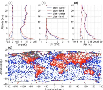
cated coincident radiosondes were launched under satellite overpasses for a reasonable period (e.g., Tobin et al., 2006; Pougatchev, 2008). This atmospheric profile retrieval is a solution of an “ill-posed” problem and its retrieval accuracy is measurement or scene dependent. Thus, it is important to estimate retrieval accuracy through global synthetic sim-ulations, intensive field campaigns, and validations. The re-trieval accuracy analysis with a single field-of-view (FOV) retrieval algorithm reported here has been performed through synthetic simulations with IASI instrumental noise over a global dataset for both cloud-free and cloudy conditions. A test dataset is used to simulate IASI observations for physi-cal retrieval performance analysis. It is noted that this kind of error analysis is dependent on the test dataset; however, the analysis can be done over a large set of samples to mini-mize the bias of the test dataset. Since the absolute retrieval error is observation or scene dependent, retrieval accuracy is represented by the mean difference (i.e., bias) and the stan-dard deviation of the error (i.e., STDE) over a global dataset in three separate categories: (1) clear-sky over water, (2) clear-sky over land, and (3) cloudy conditions. Key thermo-dynamic parameters, such as atmospheric temperature pro-file, moisture propro-file, surface skin temperature and emissivity (for cloud-free cases) or cloud microphysical parameters (for cloudy cases), are used to indicate retrieval accuracy over a global dataset.
2244 D. K. Zhou et al.: All weather IASI single field-of-view retrieval
Fig. 2. Retrieval error analysis over IASI simulated clear-sky ob-servations. Panels(a–c)are the bias and STDE of temperature and moisture profiles for observations over water (blue curves) and land (red curves); and associated geophysical locations of the observa-tions are indicated in panel(d)over water (blue dots) and land (red dots).
Fig. 3. Retrieval error analysis over IASI simulated cloudy obser-vations. Panels(a–c)are the bias and STDE of temperature and moisture profiles and associated geophysical locations of the obser-vations are indicated in panel(d).
noticed in the boundary layer for both temperature and mois-ture profilers which is due to (1) lower retrieval sensitivity in the boundary layer, dependent on surface skin temperature contrast with the surface air temperature, (2) retrieved sur-face parameter (skin temperature and emissivity)
uncertain-Fig. 4. Retrieved cloud parameter plotted against the truth: Hc, COT, and De (see text) are in panels(a–c), respectively.
ties, and (3) the complexity of boundary layer structure and variation. The STDE and bias of surface skin temperature (TS) are listed in Table 1. Under cloudy conditions, Fig. 3a– c show statistical results for temperature and moisture pro-files retrieved from sample locations indicated in Fig. 3d. The corresponding retrieval accuracy is shown in Fig. 3a– c. The associated cloud parameters (i.e., Hc, COT, and De)
Table 1. Surface temperature and cloud parameters retrieval error statistics relative to “truth”.
Clear over water Clear over land Cloudy
No. of Samples 6262 5868 3172
Ts Bias, K 0.05 0.25 NA
Ts STDE, K 0.97 1.42 NA
Hc Bias, km NA NA 0.29
Hc STDE, km NA NA 1.66
COT Bias NA NA −0.25
COT STDE NA NA 0.79
De Bias,µm NA NA −2.48
De STDE,µm NA NA 11.60
Fig. 5. Standard deviation of atmospheric temperature and mois-ture profiles of the retrieval testing dataset. Cloud-free atmospheric conditions are plotted in panels(a–c); profiles over water and land are plotted in red and blue, respectively. Cloudy atmospheric con-ditions are plotted in panels(d–f).
“truth.” The diversity of the test dataset, as represented by its standard deviation (STD), is compared with that of the retrievals from the radiances simulated for the test dataset. Fig. 5 shows plots of the STD of the test dataset (listed in Table 1) and its associated retrievals, indicating a large di-versity of atmospheric conditions in this global coverage test dataset. As shown, variability of the atmospheric profiles is captured by the retrievals; however, the retrieval accuracy is better under cloud-free conditions than under cloudy condi-tions, especially with the moisture.
3 JAIVEx Retrievals and Inter-comparisons
The Houston, Texas based JAIVEx, which took place from 14 April to 4 May 2007, has gathered a wealth of useful
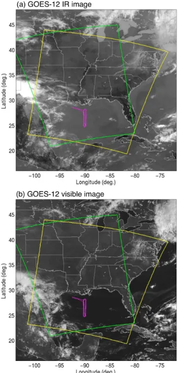
Fig. 6. GOES-12 IR and visible images shown in panels(a)and (b)with WB-57 aircraft flight track (in magenta), IASI granule (in yellow), and AIRS granule (green) boundaries.
2246 D. K. Zhou et al.: All weather IASI single field-of-view retrieval
Fig. 7.Retrieval fitting residuals and their distribution under clear conditions are in panels(a)and(b)while cloudy conditions are in panels (c)and(d); samples of spectral fitting of IASI bands 1 and 2 are in panels(e–f)for clear and cloudy conditions, respectively; statistical bias and a STDE are in panels(g–h)for clear and cloudy conditions, respectively (see text).
Radiation Measurement-Cloud And Radiation Test-bed) site. Radiosondes were launched from the ARM-CART site dur-ing Metop-A overpasses. Durdur-ing the JAIVEx, the NASA WB-57 aircraft, together with the UK FAAM BAe-146 air-craft, made flights dedicated to IASI validation. Ultraspectral instruments, such as the NAST-I, flew on the NASA WB-57 aircraft to provide measurements for IASI radiance and retrieval intercomparison (Larar et al., 2009). Numerous in-situ sensors and remote sensing instruments flew on the BAe-146 aircraft, and dropsondes were released from the BAe-BAe-146 during under flights of IASI. Most JAIVEx data have been processed and geophysical parameters retrieved from IASI, AIRS, and NAST-I, which can be used to assess both retrieval accuracy and instrument performance. However, only the re-sults from 29 April 2007 are presented here to illustrate the IASI radiometric performance and retrievals obtained during the JAIVEx. Both the WB-57 and BAe-146 aircraft flew for a period of time long enough to under fly the Metop-A and the Aqua satellites. Fig. 6a and b show GOES-12 infrared and visible images taken at 15:33 UTC. The IASI overpass
was around 15:48 UTC with a granule of data being obtained within the yellow box and the AIRS overpass was around 19:30 UTC with a granule of data being collected within the green box. The NASA WB-57 (track with magenta line) and the FAAM BAe-146 aircraft were flown over the same lo-cation from 15:30 to 19:20 UTC. Comparisons are presented here for atmospheric soundings obtained from satellite ul-traspectral instrumental measurements, airborne ultraspec-tral FTS measurements, and dedicated dropsondes and ra-diosonde observations.
3.1 Retrieval consistency
“clear” in those conditions where retrievals are almost unaf-fected by the clouds. Figure 7a–d show plots of the fitting residuals, and their distributions, in the categories of clear and cloudy conditions identified by the retrieval. It is noted that they are limited to fitting residuals of less than 1.2 K. There are 131 out of 5400 profiles in this granule that have their fitting residuals greater than 1.2 K; most of them are due to low quality observed radiances and some complexity of cloudy conditions which are just too hard to handle with this retrieval system. Nevertheless, the percentage with a fitting residual greater than 1.2 K is very small, i.e., less than 3% for this case. Fitting residuals shown in Fig. 7a and b for clear conditions are much smaller than fitting residuals shown in Fig. 7c and d for cloudy conditions. This is expected since there are more variables to be retrieved under cloudy con-ditions, and the radiative transfer model error (also consid-ered as “equivalent instrument noise”) is increased when the cloud model is introduced. Radiance fitting residual samples from both clear and cloudy cases are shown in Fig. 7e and f, respectively; and statistical analyses producing a bias and a STDE over 4786 clear and 483 cloudy samples are plotted in Fig. 7g and h, respectively. It is noted that the fitting resid-ual threshold of 1.2 K used for this case is arbitrary such that there may be a few retrievals with suboptimal accuracy, espe-cially if cloud misdetection occurs. However, this threshold can be modified by the user to filter erroneous data or more simply used as a retrieval quality indicator.
3.2 Cloud and surface parameters
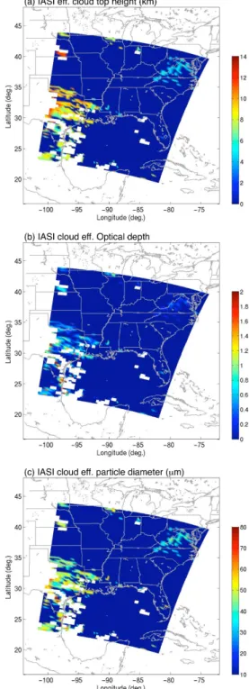
IASI retrievals include effective cloud microphysical prop-erties, surface parameters (under clear conditions), and at-mospheric temperature and moisture profiles. Cloud micro-physical parameters retrieved from the IR ultraspectral data are “effective” in the sense that they depend on instrument characteristics (e.g., FOV size) and spectral dependence of the infrared sensitivity of the cloud property. For instance, observed IR radiance has a limited sensitivity to variation of cloud optical depth for large values, i.e., a retrieved “effec-tive” optical depth of an opaque cloud can be quite different from the real optical depth of the cloud. Although the cloud retrieval algorithm has been evaluated with aircraft data (e.g., dropsondes and CPL) from the THORPEX Atlantic Regional Campaign (ATReC) (Zhou et al., 2007a), more validations for diverse cloud conditions are desired to give definitive conclusions regarding the retrieval accuracy. Unfortunately, cloud parameters derived from the JAIVEx radiance spectra cannot be thoroughly validated because extensive cloud truth data is not available. However, IASI retrieved cloud distri-butions and effective cloud heights (Fig. 8a) can be graphi-cally validated using GOES-12 images (i.e., Fig. 6a and b). Retrieved effective cloud optical depth and particle size (in diameter) are plotted in Fig. 8b and c. It is found that cloud detection with IASI is less accurate for low cloud top heights (i.e., less than 3 km) over the water. This is due to the
rel-Fig. 8.IASI retrieved cloud height, optical depth, and particle size are in panels(a–c), respectively (see text).
atively poor contrast between the cloud temperature and the underlying sea surface skin temperature. Detailed investiga-tions are currently underway to improve the retrieval accu-racy for this situation.
2248 D. K. Zhou et al.: All weather IASI single field-of-view retrieval
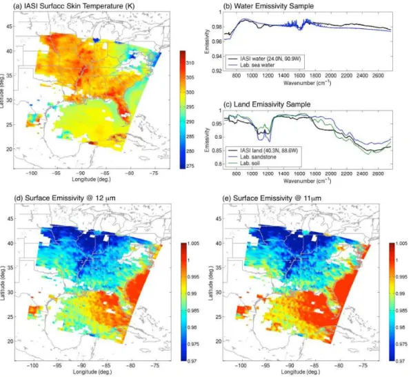
Fig. 9.Surface parameters retrieved from IASI. Panel(a)is surface skin temperature, panels(b, c)are samples of emissivity spectra of water and land, respectively, and panels(d–e)are emissivity distributions at 12-µm and 11-µm, respectively. Notice that white areas were covered with clouds.
critical in obtaining accurate atmospheric profiles near the surface, especially over land where emissivities have a larger variation (Zhou et al., 2006; Zhou et al., 2007a). Fig. 9 plots surface skin temperature and samples of emissivity im-ages. This case was made with the BAe-146 aircraft fly-ing as low as 30 m above the sea; the sea surface temper-ature (SST) and emissivity are observed with the Airborne Research Interferometer Evaluation System (ARIES) (e.g., Newman et al., 2005; Taylor et al., 2008). NAST-I and ARIES observations within the IASI FOV are used for the intercomparison. IASI retrieved skin temperature over the water (27.07◦N, 90.53◦W) is 297.33 K. This is within 0.5 K
of the NAST-I, ARIES, and nearby buoy (station 42 362 at 27.80◦N, 90.67◦W) water temperature measurements of
297.82 K, 297.77 K, and 297.15 K, respectively. A sample of the water emissivity spectrum retrieved from IASI radiances is plotted in Fig. 9b together with a laboratory measured sea-water emissivity spectrum. Land surface skin temperature and emissivity have not been evaluated because of lack of
ground truth data and the non-homogeneity of the land sur-face within the IASI FOV (12 km). However, it is evident that the land emissivity distributions differ from that of wa-ter. The small variation of water surface emissivity is ex-pected due to its surface wind speed dependence. A sample of land emissivity, for a bare-soil spot, is plotted in Fig. 9c along with a laboratory measurement of soil and sandstone emissivity. Surface emissivity images at 12 and 11µm are plotted in Fig. 9d and e, respectively, to reveal the spectral dependence on underlying surface type.
3.3 Atmospheric temperature and moisture profiles
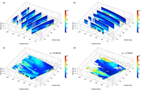
Fig. 10. Relative humidity distribution retrieved from IASI radiance spectra. Panels(a–b)plot the vertical cross sections along and across the satellite track, and panels(c–d)plot the horizontal cross sections at an altitude of 12.06 km and 4.79 km respectively.
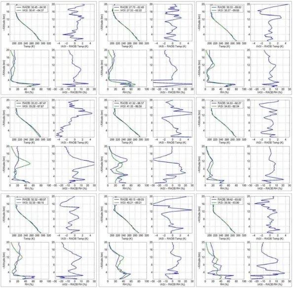
shown in Fig. 10. A coherent distribution is shown even though the retrieval is performed independently for each in-dividual FOV without any correlation between the neighbor-ing FOVs. Retrievals over the continental US were compared to the radiosonde observations. Selected retrievals vs. ra-diosondes plots are shown in Fig. 11. It is noted that the IASI observations were made at approximately 15:48 UTC (i.e., 10:48 a.m. local time) while the radiosondes were launched at 12:00 UTC (i.e., 7:00 a.m. local time). The bias and STDE of these temperature and relative humidity sounding pro-files are plotted in Fig. 12; however, these comparisons are not to be used to identify the retrieval error and/or accuracy because of unknown field evolution, especially for rapidly changing moisture and cloud conditions. The difference be-tween retrieval and radiosonde is due to a combination of atmospheric temporal variation in addition to the errors in both the retrievals and the radiosondes. In other words, at-mospheric evolution characteristics near the radiosonde lo-cation could be subtle or obvious. However, these inter-comparisons, in conjunction with thermodynamic field re-trieved with IASI (e.g., Fig. 10), indicate that atmospheric variations from location-to-location are captured with IASI observations.
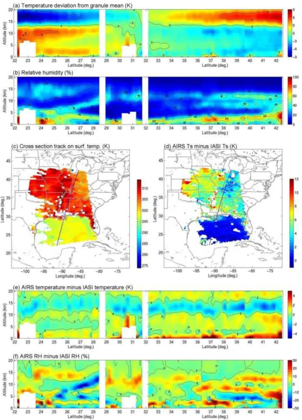
In order to obtain coincident sounding profiles for retrieval validation, the NASA WB-57 and FAAM BAe-146 aircraft flew under the Metop-A satellite to provide NAST-I radiance observations very similar to IASI and dropsonde observa-tions. Figure 13a–b show cross-sections of temperature de-viation from their granule mean and relative humidity (RH);
geophysical locations of the cross section (dashed curve) are plotted in Fig. 13c. One radiosonde launched at 12 UTC near the track (i.e., cross section) is also plotted in Fig. 13d against a co-located IASI retrieval, despite there being a several hour gap between the IASI and radiosonde observations. Sondes were dropped from BAe-146 aircraft at the Metop-A over-pass time. Two of these dropsondes, one at the most south-ern and the other at the most northsouth-ern flight locations shown on the map (Fig. 13c), are plotted in Fig. 13e and f against co-located IASI retrievals. Although these locations are not far apart, each individual comparison is made for a very dif-ferent atmospheric condition. IASI retrievals captured the atmospheric variations, especially for water vapor, between these locations. The variation of water vapor from the upper atmosphere down through the boundary layer to the surface is captured as confirmed by the dropsonde and radiosonde observations. The differences between IASI retrievals and dropsonde observations are within the accuracy estimated in Sect. 2. Large peak-to-peak differences are due to the higher vertical resolution of dropsondes, the difference being within the retrieval accuracy estimated in Sect. 2 when layer aver-aged profiles are compared (not shown here).
2250 D. K. Zhou et al.: All weather IASI single field-of-view retrieval
Fig. 11.Selected retrievals (15:48 UTC) vs. radiosondes (12:00 UTC) over continental US.
Fig. 12. The bias and STDE of temperature and relative humidity profiles from a total of 16 IASI retrievals and radiosondes (some are plotted in Fig. 11).
2252 D. K. Zhou et al.: All weather IASI single field-of-view retrieval
Fig. 15. (a)IASI RH cross-section near aircraft flight domain,(b)NAST-I RH shown as a function of time: aircraft flight direction of each leg is shown by the arrow and the flight leg duration (in UTC) is labeled, and(c)AIRS RH cross-section interpolated to IASI FOV locations.
Fig. 16. RH evolution characteristic between AIRS and IASI measurements observed by (a)AIRS at 19:30 UTC and IASI at 15:48 UTC, and(b)by NAST-I at 19:11 UTC and 15:40 UTC.
The WB-57 aircraft IASI under-flights within the cross sec-tions shown in Figs. 13 and 14 are used to verify the subtle field evolution that occurred between the time of the IASI and AIRS observations. NAST-I relative humidity cross-sections are plotted in Fig. 15 as a function of time. The relative humidity difference between AIRS and IASI is plotted in Fig. 16a and compared with that observed by NAST-I plot-ted in Fig. 16b (i.e., the difference between Leg 1 and Leg 8). The difference is mainly due to (1) instrumental differ-ences between IASI (Fig. 15a) and AIRS (Fig. 15c), (2) spa-tial resolution differences between NAST-I and IASI (and/or AIRS), and (3) retrieval uncertainty including radiative trans-fer model diftrans-ferences (i.e., SARTA for AIRS and IASI while OSS for NAST-I). Nevertheless, these differences are within the goal of RH retrieval accuracy. The spatial characteris-tics of the field are very similar between NAST-I, IASI, and AIRS. The temporal variation between IASI and AIRS ob-servation times is revealed by NAST-I measurements.
4 Summary
2254 D. K. Zhou et al.: All weather IASI single field-of-view retrieval is obtained in that the standard deviation of differences is
under 1 K for temperature, less than 10% for RH above the terrestrial boundary layer (TBL), and 10 to 20% for RH in the TBL (see Sect. 3.3). This study indicates that IASI radi-ance measurements meet the requirements of Level 2 prod-ucts with respect to the product accuracy found in the EPS End User Requirements Document (EURD). Additional val-idation analyses for both clear and cloudy conditions are on-going to provide more definitive conclusions. Nevertheless, fine-scale atmospheric horizontal features with high vertical resolution from satellite global observations with advanced ultraspectral instruments have been realized for the first time. Acknowledgements. The authors greatly appreciate the contribu-tions of the NASA Langley Research Center, the Space Science and Engineering Center of the University of Wisconsin – Madison, and the UK Met Office. The NAST-I program is supported by the NPOESS Integrated Program Office, NASA Headquarters, and NASA Langley Research Center. The FAAM is jointly funded by the UK Met Office and the Natural Environment Research Council. IASI has been developed and built under the responsibility of the Centre National d’Etudes Spatiales (CNES). It is flown onboard the Metop satellites as part of the EUMETSAT Polar System. The IASI L1 data are received through the Unified Meteorological Archival and Retrieval Facility (UMARF) of EUMETSAT.
Edited by: A. Richter
References
Aires, F., Chedin, A., Scott, N. A., and Rossow, W. B.: A regres-sion neural net approach for retrieval of atmospheric and surface temperatures with the IASI instrument, J. Appl. Meteorol., 41, 144–159, 2002.
Aumann, H. H., Chahine, M. T. Gautier, C., Goldberg, M. D., Kalnay, E., McMillin, L. M., Revercomb, H., Rosenkranz, P. W., Smith, W. L., Staelin, D. H., Strow, L., and Susskind, J.: AIRS/AMSU/HSB on the Aqua mission: design, science objec-tive, data products, and processing systems, IEEE T. Geosci. Re-mote, 41, 253–264, 2003.
Blumstein, D., Chalon, G., Carlier, T., Buil, C., Hebert, P., Maci-aszek, T., Ponce, G., and Phulpin, T.: IASI instrument: technical overview and measured performances, SPIE Proc. 5543, 196– 207, 2004.
Borbas, E., Seemann, S. W., Huang, H.-L., Li, J., and Menzel, W. P.: Global profile training database for satellite regression re-trievals with estimates of skin temperature and emissivity, Proc. Int. ATOVS Study Conf. XIV, Beijing, China, CIMSS, Univer-sity of Wisconsin-Madison, 763–770, 2005.
Chahine, M. T., Pagano, T. S., Aumann, H. H., Atlas, R., Bar-net, C., Blaisdell, J., Chen, L., Divakarla, M., Fetzer, E. J., Gold-berg, M., Gautier, C., Granger, S., Hannon, S., Irion, F. W., Kakar, R., Kalnay, E., Lambrigtsen, B. H., Lee, S.-Y., Le Mar-shall, J., McMillan, W. W., McMillin, L., Olsen, E. T., Rever-comb, H., Rosenkranz, P., Smith, W. L., Staelin, D., Strow, L. L., Susskind, J., Tobin, D., Wolf, W., and Zhou, L.: AIRS: improv-ing weather forecastimprov-ing and providimprov-ing new insights into climate, B. Am. Meteorol. Soc., 87, 911–926, 2006.
Cousins, D. and Smith, W. L.: National Polar-Orbiting Operational Environmental Satellite System (NPOESS) Airborne Sounder Testbed-Interferometer (NAST-I), SPIE Proc., 3127, 323–331, 1997.
Eldering, A., Kahn, B. H., Mills, F. P., Irion, F. W., Steele, H. M., Gunson, M. R.: Vertical profiles of aerosol volume from high spectral resolution infrared transmission measurements: Results, J. Geophys. Res., 109, D20201, doi:10.1029/2004JD004623, 2004.
Hansen, P. C.: Rank-Deficient and Discrete Ill-Posed Problems: Numerical Aspects of Linear Inversion. Society for Industrial and Applied Mathematics [SIAM] Monographs on Mathemati-cal Modeling and Computation #4, Philadelphia, PA, USA, 247 pp., 1998.
Heymsfield, A. J., Matrosov, S., and Baum, B.: Ice water path– optical depth relationships for cirrus and deep stratiform ice cloud layers, J. Appl. Meteorol., 42, 1369–1390, 2003.
Klaes, K. D., Cohen, M. Buhler, Y., Schl¨ussel, P., Munro, R., Lun-tama, J.-P., Von Engeln, A., Clerigh, E. ´O., Bonekamp, H., Ack-ermann, J., Schmetz, J.: An introduction to the EUMETSAT Po-lar System, B. Am. Meteorol. Soc, 88, 1085–1096, 2007. Li, J.: Temperature and water vapor weighting functions from
ra-diative transfer equation with surface emissivity and solar reflec-tivity, Adv. Atmos. Sci., 11, 421–426, 1994.
Larar, A. M, Smith, W. L., Zhou, D. K., Liu, X., Revercomb, H., Taylor, J. P., Newman, S. M., and Schl¨ussel, P.: IASI spectral radiance performance validation: case study assessment from the JAIVEx field campaign, Atmos. Chem. Phys., submitted, 2009. Liu, X., Moncet, J.-L., Zhou, D. K., and Smith, W. L.: A Fast and
Accurate Forward Model for NAST-I Instrument, in: Fourier Transform Spectroscopy and Optical Remote Sensing of At-mosphere, 2003 Technical Digest Series OSA, Opt. Soc. Am., Washington, DC, USA, p. 16., 2003.
Ma, X. L., Schmit, T. J., and Smith, W. L.: A nonlinear physical retrieval algorithm – its application to the GOES-8/9 sounder, J. Appl. Meteorol., 38, 501–513, 1999.
Moncet, J. L., Liu, X., Rieu-Isaacs, H., Snell, H., Zaccheo, S., Lynch, R., Eluszkiewicz, J., He, Y., Uymin, G., Lietzke, C., Hegarty, J., Boukabara, S., Lipton, A., and Pickle, J.: Algo-rithm theoretical basis document (ATBD) for the Cross Track Infrared Sounder (CrIS) environmental data records (EDR), V1.2.3, AER document P882-TR-E-1.2.3-ATBD-03-01, Atmos. Environ. Res., Boston, Mass., USA, 2003.
Newman, S. M., Smith, J. A., Glew, M. D., Rogers, S. M., and Taylor, J. P.: Temperature and salinity dependence of sea surface emissivity in the thermal infrared, Q. J. Roy. Meteor. Soc., 131, 2539–2557, 2005.
Pagano, T. S., Aumann, H. H., Hagan, D. E., and Overoye, K.: Prelaunch and in-flight radiometric calibration of the Atmo-spheric Infrared Sounder (AIRS), IEEE T. Geosci. Remote, 41, 265–273, 2003.
Pougatchev, N.: Validation of Atmospheric Sounders by Correlative Measurements, Appl. Optics, 47, 4739–4748, 2008.
Rodgers, C. D.: Retrieval of atmospheric temperature and composi-tion from remote measurements of thermal radiacomposi-tion, Rev. Geo-phys. Space G., 14, 609–624, 1976.
Seemann, S. W., Borbas, E. E., Knuteson, R. O., Stephenson, G. R., and Huang, H.-L.: Development of a global infrared land surface emissivity database for application to clear-sky sounding retrievals from multi-spectral satellite radiance measurements, J. Appl. Meteorol. Clim., 47, 108–123, 2008.
Smith, W. L., Zhou, D. K., Huang, H.-L., Li, J., Liu, X., and Larar, A. M.: Extraction of profile information from cloud contami-nated radiances, paper presented at the ECMWF Workshop on the Assimilation of High Spectral Resolution Sounders in NWP, June 28–July 1, 2004.
Stamnes, K., Tsay, S.-C., Wiscombe, W., and Jayaweera, K.: Nu-merically stable algorithm for discrete-ordinate-method radiative transfer in multiple scattering and emitting media, Appl. Optics, 27, 2502–2509, 1988.
Strow, L. L., Hannon, S. E., De Souza-Machado, S., Motteler, H. E., and Tobin, D.: An overview of the AIRS radiative transfer model, IEEE T. Geosci. Remote, 41, 303–313, 2003.
Taylor, J. P., Smith, W. L., Cuomo, V., Larar, A. M., Zhou, D. K., Serio, C., Maestri, T., Rizzi, R., Newman, S., Antonelli, P., Mango, S., Di Girolamo, P., Esposito, F., Grieco, G., Summa, D., Restieri, R., Masiello, G., Romano, F., Pappalardo, G., Pavese, G., Mona, L., Amodeo, A., and Pisani, G.: EAQUATE – An in-ternational experiment for hyper-spectral atmospheric sounding validation, B. Am. Meteorol. Soc., 89, 203–218, 2008.
Tikhonov, A. N.: On the solution of incorrectly stated problems and a method of regularization, Dokl. Acad. Nauk. SSSR, 151, 501– 504, 1963.
Tobin, D. C., Revercomb, H. E., Knuteson, R. O., Lesht, B. M., Strow, L. L., Hannon, S. E., Feltz, W. F., Moy, L. A., Fetzer, E. J., and Cress, T. S.: Atmospheric Radiation Measurement site at-mospheric state best estimates for Atat-mospheric Infrared Sounder temperature and water retrieval validation, J. Geophys. Res., 111, D09S14 doi:10.1029/2005JD006103, 2006.
Twomey, S.: On the numerical solution of Fredholm integral equa-tions of the first kind by inversion of the linear system produced by quadrature, J. Assoc. Comput. Mach., 10, 97–101, 1963. Weisz, E., Li, J., Li, J., Zhou, D. K., Huang, H., Goldberg, M. D.,
and Yang, P.: Cloudy sounding and cloud-top height retrieval from AIRS alone single field-of-view radiance measurements, Geophys. Res. Lett., 34, L12802, doi:10.1029/2007GL030219, 2007.
Yang, P., Gao, B. C., Baum, B. A., Hu, Y., Wiscombe, W. J., Tsay, S.-C., Winker, D. M., and Nasiri, S. L.: Radiative Properties of cirrus clouds in the infrared (8–13µm) spectral region, J. Quant. Spectros. Rad., 70, 473–504, 2001.
Zhou, D. K., Smith, W. L., Li, J., Howell, H. B., Cantwell, G. W., Larar, A. M., Knuteson, R. O., Tobin, D. C., Revercomb, H. E., and Mango, S. A.: Thermodynamic product retrieval methodol-ogy for NAST-I and validation, Appl. Opt., 41, 6957–6967, 2002. Zhou, D. K., Smith, W. L., Liu, X., Larar, A. M., Huang, H.-L. A., Li, J., McGill, M. J., and Mango, S. A.: Thermodynamic and cloud parameters retrieval using infrared spectral data, Geophys. Res. Lett., 32, L15805, doi:10.1029/2005GL023211, 2005. Zhou, D. K., Larar, A. L., Smith, W. L., and Liu, X.: Surface
emis-sivity effects on thermodynamic retrieval of IR spectral radiance, Proc. SPIE 6405, 64051H, 2006.
Zhou, D. K., Smith, Sr., W. L., Liu, X., Larar, A. M., Mango, S. A., and Huang, H.-L.: Physically retrieving cloud and thermody-namic parameters from ultraspectral IR measurements, J. Atmos. Sci., 64, 969–982, 2007a.