HESSD
9, 10877–10916, 2012Modeling postfire water erosion mitigation strategies
M. C. Rulli et al.
Title Page
Abstract Introduction
Conclusions References
Tables Figures
◭ ◮
◭ ◮
Back Close
Full Screen / Esc
Printer-friendly Version Interactive Discussion
Discussion
P
a
per
|
Dis
cussion
P
a
per
|
Discussion
P
a
per
|
Discussio
n
P
a
per
|
Hydrol. Earth Syst. Sci. Discuss., 9, 10877–10916, 2012 www.hydrol-earth-syst-sci-discuss.net/9/10877/2012/ doi:10.5194/hessd-9-10877-2012
© Author(s) 2012. CC Attribution 3.0 License.
Hydrology and Earth System Sciences Discussions
This discussion paper is/has been under review for the journal Hydrology and Earth System Sciences (HESS). Please refer to the corresponding final paper in HESS if available.
Modeling postfire water erosion
mitigation strategies
M. C. Rulli1, L. Offeddu1, and M. Santini2
1
Politecnico di Milano, Piazza L. Da Vinci, 32, Milano, 20133 Italy
2
Centro euroMediterraneo sui Cambiamenti Climatici, Lecce, Italy
Received: 4 September 2012 – Accepted: 17 September 2012 – Published: 27 September 2012
Correspondence to: M. C. Rulli ([email protected])
HESSD
9, 10877–10916, 2012Modeling postfire water erosion mitigation strategies
M. C. Rulli et al.
Title Page
Abstract Introduction
Conclusions References
Tables Figures
◭ ◮
◭ ◮
Back Close
Full Screen / Esc
Printer-friendly Version Interactive Discussion
Discussion
P
a
per
|
Dis
cussion
P
a
per
|
Discussion
P
a
per
|
Discussio
n
P
a
per
|
Abstract
Severe wildfires are often followed by significant increase in runoffand erosion, due to vegetation damages and changes in physical and chemical soil properties. Peak flows and sediment yields can increase up to two orders of magnitude becoming dangerous for human lives and ecosystem, especially in the wildland-urban interface. Watershed
5
post fire rehabilitation measures are usually used to mitigate the effects of fire on runoff
and erosion, by protecting soil from splash and shear stress detachment and enhanc-ing its infiltration capacity. Modelenhanc-ing post fire erosion and erosion mitigation strategies can be useful in selecting the effectiveness of rehabilitation method. In this paper a dis-tributed model based on Revised Universal Soil Loss Equation (RUSLE), properly
pa-10
rameterized for a Mediterranean basin located in Sardinia, is used to determine soil losses for six different scenarios describing both natural and post-fire basin condition, the last accounting also for the single and combined effect of different erosion mitigation measures. Fire effect on vegetation and soil properties have been mimed by changing soil drainage capacity and organic matter content, and RUSLE factors related to soil
15
cover and protection measures.
Model results show for the analyzed rehabilitation treatments their effect in reducing the amount of soil losses with the peculiar characteristics of the spatial distribution of such changes.
1 Introduction
20
Forest fires in Mediterranean area are natural processes due to the mutual interactions between climate and vegetation forging the biodiversity typical of this ecosystem (e.g. Ursino and Rulli, 2011; Pausas and Paula, 2012). During the last decades the number, extent and severity of forest fires in the Mediterranean countries increased as a result of abandonment of agricultural lands, inadequate forest management, long seasonal
25
HESSD
9, 10877–10916, 2012Modeling postfire water erosion mitigation strategies
M. C. Rulli et al.
Title Page
Abstract Introduction
Conclusions References
Tables Figures
◭ ◮
◭ ◮
Back Close
Full Screen / Esc
Printer-friendly Version Interactive Discussion
Discussion
P
a
per
|
Dis
cussion
P
a
per
|
Discussion
P
a
per
|
Discussio
n
P
a
per
|
et al., 2006; Shakesby, 2011) leading to the alteration of natural fire regime. Follows that areas usually experiencing frequent low severity fires, are now hit by less frequent high severity fires and other areas, adapted to high severity fire, are now subjected to an increase in fire frequency (Ful ´e et al., 2008). As a results, mediterranean ecosystem is reducing its resilience to fire. Appropriate mitigation strategies can reduce the negative
5
consequences of fire through a deep comprehension of fire effects and sustainable coexistence with forest fires, in terms of both human security and ecological processes (Pausas and Verd `u, 2008).
Fire effects consist on direct damage of vegetation and alteration of physical and chemical soil properties which affect in turn the hydrological response and sediment
10
erosion and transport (e.g. Moody et al., 2008; Andreu et al., 2001). In particular, both runoffand even more erosion in the first year after fire occurrence are often increased several times compared to natural condition (Rulli and Rosso, 2005). Measurements taken in the Sila Massif in Calabria (Italy) showed an 87 % increase in runoffon areas recently burned compared to non burned areas (Terranova et al., 2009), and rainfall
15
simulations in Liguria (Italy) showed post-fire overland flow and sediment yield, re-spectively one and two orders of magnitude higher in a recently burnt site than in a long unburned site (Rulli et al., 2006).
Although the association among wildfire, flooding, increase in erosion and sedimen-tation has been observed all over the world (e.g. Benavides-Solorio and Mac
Don-20
ald, 2005; Cerd `a, 1998; Emmerich and Cox, 1994; Shakesby, 2011; Terranova et al. 2009) post wildfire research, especially regarding fire induced erosion enhancement, has a relatively brief history in the Mediterranean, starting from about the early 1980s (corresponding to the dramatic increase in fire activity) (Shakesby, 2011).
Burn severity has been identified as one of the most important variables affecting
25
HESSD
9, 10877–10916, 2012Modeling postfire water erosion mitigation strategies
M. C. Rulli et al.
Title Page
Abstract Introduction
Conclusions References
Tables Figures
◭ ◮
◭ ◮
Back Close
Full Screen / Esc
Printer-friendly Version Interactive Discussion
Discussion
P
a
per
|
Dis
cussion
P
a
per
|
Discussion
P
a
per
|
Discussio
n
P
a
per
|
are loss of organic matter (e.g. Soto and Diaz-Ferros, 1998), increase of bulk den-sity (Neary et al., 2005), reduction of soil poroden-sity and infiltration capacity (Robichaud et al., 2010), increase of soil water repellency (e.g. De Bano, 2000; Doerr et al., 2009). Other important factors, are rainfall intensity, slope and aspect, antecedent soil mois-ture (Wischmeyer and Smith, 1978), soil aggregate stability (Fox et al., 2008) grade
5
of soil water repellency (Keizer et al., 2008), and the time interval between the fire episode and the occurrence of rainfall (Rulli et al., 2006). Univariate analysis conduced on sediment yields in Colorado Front Range burned hillslopes showed that about 77 % of the variability in post fire erosion rates is explained by five main factors: fire sever-ity, bare soil percent cover, rainfall erosivsever-ity, soil water repellency and texture. Among
10
these, bare soil percentage and rainfall erosivity alone explained 66 % of variability in soil loss measurements (Benavides-Solorio and Mac Donald, 2005).
Strategies for watershed post fire rehabilitation are mainly aimed to soil cover and infiltration capacity restoration, and sediment detachment and downslope sediment transport reduction (e.g. Fern `andez et al., 2010; Myronidis et al., 2009; Neary et al.,
15
2005; Robichaud et al., 2010; Wohlgemuth et al., 2009) so acting mostly on soil char-acteristics like soil vegetation cover, erodibility, permeability or infiltration capacity.
There are many different mitigation strategies, which are suitable for diverse situa-tions, and whose results depend on when, how and where they are applied (Wohlge-muth et al., 2009). Post fire treatments may be applied to hillslopes, channels and
road-20
ways. Treatments used on hillslopes can be divided in three main types: mulch treat-ments, erosion barriers and chemical treatments (Neary et al., 2005; Robichaud and El-liot, 2006). Hillslope treatments are designed to avoid sediment delivery to downstream water bodies and they are considered the most useful (Robichaud, 2009). Wagen-brenner et al. (2007) observed ground cover greatly influencing sediment production,
25
HESSD
9, 10877–10916, 2012Modeling postfire water erosion mitigation strategies
M. C. Rulli et al.
Title Page
Abstract Introduction
Conclusions References
Tables Figures
◭ ◮
◭ ◮
Back Close
Full Screen / Esc
Printer-friendly Version Interactive Discussion
Discussion
P
a
per
|
Dis
cussion
P
a
per
|
Discussion
P
a
per
|
Discussio
n
P
a
per
|
of vegetation regrowth. It produces soil protection from rain splash detachment and soil stabilization (Robichaud et al., 2007b; Wohlgemuth et al., 2009). For this purpose, several materials can be used: dry straw or wood-based mulches, wet mulches (hydro-mulch) mixed with water to form a slurry (Neary et al., 2005). Post-fire mulching needs to provide 60–80 % ground cover to reduce hillslope erosion (Robichaud et al., 2010).
5
Some problems can arise by using this technique consisting in mulches slopes slipping down, aerially spread mulches residual vegetation interception, so reducing the actual ground cover and potential effectiveness (Neary et al., 2005; Robichaud et al., 2010).
Erosion barriers are commonly placed in a way to capture sediments and interrupt long flow paths, so decreasing downslope shear stress soil erosion and sediment
trans-10
port on hillslopes and into streams. Erosion barriers can be contour-felled logs, straw wattles, contour trenches, straw bales (Neary et al., 2005). A barrier treatment per-formance can be defined as the ratio of dry weight of sediment stored by the barrier and dry weight of collected sediment below the barrier. Erosion barriers present some weakness reducing runoffand soil loss for low intensity rain events, but do not achieve
15
significant results for high intensity events. In addition, the capacity of barriers can be overtopped soon after the first rain events, so determining the uselessness of not cleaned offbarriers (Robichaud et al., 2010).
Rehabilitation treatments like ploughing or tilling on croplands burned areas are usu-ally used to decrease soil aggregation and to break up the fire-induced water repellent
20
soil layer to restore drainage capacity (Keizer et al., 2008).
Channel rehabilitation after fire is primarily done by cleaning channel beds and pre-venting obstruction of streams. The main treatments for these purposes are check dams or debris basins, debris clearing and streambank armoring (Neary et al., 2005).
Even if fire does not directly affect road drainage system, the increased overland
25
HESSD
9, 10877–10916, 2012Modeling postfire water erosion mitigation strategies
M. C. Rulli et al.
Title Page
Abstract Introduction
Conclusions References
Tables Figures
◭ ◮
◭ ◮
Back Close
Full Screen / Esc
Printer-friendly Version Interactive Discussion
Discussion
P
a
per
|
Dis
cussion
P
a
per
|
Discussion
P
a
per
|
Discussio
n
P
a
per
|
Despite the observation of large post fire increase in soil losses in the Mediterranean area (e.g. Shakesby, 2011 and the references herein) analysis of the efficiency of post-fire erosion mitigation strategies are very scarce. Field studies assessing the eff ective-ness of mulching and barriers were carried out in Spain (e.g. Badia and Mart`ı, 2000; Bautista et al., 2009; Fern `andez et al., 2011) and in Portugal (Ferreira et al., 2009), but
5
a systematic analysis at basin scale for the Mediterranean area is still lacking.
Given the complexity of fire-related issues, and the importance of fire effects on watershed response and erosion dynamics, accurate predictions of post-fire runoffand sediment yields are needed to guide management decisions, mitigate post-fire soil loss and land degradation and for post-fire rehabilitation planning (Fern `andez et al., 2010).
10
Land use changes impact on soil losses prediction has been carried out by using dif-ferent kind of modeling depending on study area extent, data availability and output de-gree of accuracy required. The Water Erosion Prediction Project (WEPP) model (Flana-gan and Nearing, 1995) and the disturbed-WEPP (Elliott et al., 2001) are process-based erosion prediction models evaluating mean erosion rate in natural and disturbed
15
condition. ERMiT (Robichaud et al., 2007a) is a probability-based erosion prediction model using multiple runs of WEPP model and developed to predict surface erosion from postfire hillslopes, and to evaluate the potential effectiveness of various erosion mitigation practices. Empirical models based on the Revised Universal Soil Loss Equa-tion (RUSLE) were used by several authors (e.g. Terranova et al., 2009; Fern ´andez
20
et al., 2010; Ranzi et al., 2011) to account for forest fire and land use changes ef-fect on erosion in large scales basins. Fully distributed hydro-geomorphological model was developed by Rulli and Rosso (2005, 2007) for analyzing the both hydrological and erosion and deposition process dynamic for both natural and disturbed basin condition. This paper investigates first year post fire erosion mitigation strategies effectiveness
25
HESSD
9, 10877–10916, 2012Modeling postfire water erosion mitigation strategies
M. C. Rulli et al.
Title Page
Abstract Introduction
Conclusions References
Tables Figures
◭ ◮
◭ ◮
Back Close
Full Screen / Esc
Printer-friendly Version Interactive Discussion
Discussion
P
a
per
|
Dis
cussion
P
a
per
|
Discussion
P
a
per
|
Discussio
n
P
a
per
|
describing the particular soil treatment to which the study area is subjected. In detail, the amount and spatial distribution of soil losses under natural condition, burned, after tilling/ploughing treatment, after mulching treatment, with barriers and after a combina-tion of the all treatments are examined.
2 Study area
5
The study area is the Rio Mannu river basin, located in North Sardinia, Italy (Fig. 1). Basin area is about 650 km2, mean elevation 252 m a.s.l. (minimum and maximum elevation, respectively 0 m a.s.l. and 755 m a.s.l.), mean slope 8.5◦(minimum and max-imum slope, respectively 0◦ and 63◦). Rio Mannu is located in the so-called Fossa Sarda, an area repeatedly interested in the past by marine transgressions, regressions
10
and volcanic activity, when the territory has been invaded by the sea and covered with thick sediment layers forming a big tableland. Geology consists of limestone, granites, volcanic substrates, carbonate deposits. Climate is typically Mediterranean, with hot and dry summers and mild and rainy winters. Precipitation occurs mostly in Novem-ber and DecemNovem-ber. Sudden floods may happen in winter, while the summer is usually
15
droughty.
Crops cover 60 % of the basin area with main cultivation represented by olive groves and vineyards, which are 77 % and 10 % of total area, while 10 % are cork tree plan-tations (Regione Autonoma della Sardegna, 2000). Shrub and herbaceous vegetation cover 28.4 % of the basin, with 11 % natural pasture, 10 % typical Mediterranean
scle-20
rophyllous vegetation. Urban area is about 4.4 %, with Sassari and Porto Torres repre-senting the main urban sites.
Sardinia region is one of the most fire prone area in the Mediterranean basin experi-encing on average 850 fires per year burning about 19 000 ha. During year 2009, 684 fires occurred in the island burning 37 104 ha, most of them (17 000 ha) in the same
25
HESSD
9, 10877–10916, 2012Modeling postfire water erosion mitigation strategies
M. C. Rulli et al.
Title Page
Abstract Introduction
Conclusions References
Tables Figures
◭ ◮
◭ ◮
Back Close
Full Screen / Esc
Printer-friendly Version Interactive Discussion
Discussion
P
a
per
|
Dis
cussion
P
a
per
|
Discussion
P
a
per
|
Discussio
n
P
a
per
|
suffering both damages to vegetation (crops and forest) and considerable increase in soil loss (Regione Sardegna, 2010).
3 Materials and methods
Soil loss in the six different scenarios, that is natural, burned and after application of single and combined mitigation practices are analyzed, by using a spatially distributed
5
model based on the Revised Universal Loss Equation (RUSLE) (Renard et al., 1997; McCool et al., 1995), parameterized for a Sardinian river basin. RUSLE is commonly adopted in erosion analysis for the simplicity of its structure and inputs and it is recog-nized to be appropriate for studies as the present one, where different erosion scenar-ios are analyzed and compared one with each other (e.g. Terranova et al., 2009; Ranzi
10
et al., 2012), despite its application can produce an overprediction of low sediment fluxes, and underprediction of very high erosion (e.g. Terranova et al., 2009; Solorio and Mac Donald, 2005; Mac Donald, 2007).
Digital elevation model (DEM) at 25 m resolution, previously depitted following the physically based procedure introduced by Grimaldi et al. (2007), has been used to
15
subdivide the study area in square cells of 25 by 25 m. Soil loss is then evaluated for each cell through RUSLE equation.
RUSLE quantifies soil losses (t ha−1yr−1) as
A=R·K·LS·C·P 20
where:
– R factor
R is the rainfall-runoff erosivity factor (MJ mm ha−1h−1yr−1), calculated on the basis of average monthly cumulated rainfall; the R factor has been determined using the Fournier method, from mean cumulated yearly precipitation Pyear and
25
HESSD
9, 10877–10916, 2012Modeling postfire water erosion mitigation strategies
M. C. Rulli et al.
Title Page
Abstract Introduction
Conclusions References
Tables Figures
◭ ◮
◭ ◮
Back Close
Full Screen / Esc
Printer-friendly Version Interactive Discussion
Discussion
P
a
per
|
Dis
cussion
P
a
per
|
Discussion
P
a
per
|
Discussio
n
P
a
per
|
Given the Fournier index
F =
12
P i=1
Pi2 Pyear
theR factor is calculated as
R=4.17·F−152
5
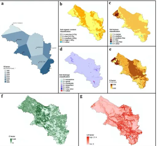
In the present studyR is obtained for seven raingauge stations based on monthly rainfall dataset over a period of 15 yr (1982–2007) (APAT, 2009). Spatially dis-tributedR factor has been obtained by applying Thiessen’s polygon method.
R factor ranges from 161 MJ mm ha−1h−1yr−1 in Porto Torres to
10
293 MJ mm ha−1h−1yr−1in Thiesi (Fig. 2a).
– K factor
K is the soil erodibility factor (t h MJ−1mm−1) (Fig. 2e), determined after Renard et al. (1997), i.e. calculated as
K =(k0·kt+ks+kd)/759.4
15
wherek0,kt,ks andkdare subfactors depending on different soil characteristics, as texture, drainage capacity, structure (soil percentage of silt, sand and clay), and organic matter content (Fig. 2b–d):
k0=12−co·1.7 (co=soil organic carbon class)
kd=2.5·(cd−3) (cd=soil drainage class)
ks=(2−cs)·3.25 (cs=soil structure class) ifvfs+%silt≤68 kt=ct (ct=soil texture class) ifvfs+%silt>68 kt=ct−0.67·(ct−2.1·(6800(1−%clay)
1.14
)/10 000)0.82
vfs=0.74·%sand−0.62·%sand 2
vfs =percentage of very fine sand
HESSD
9, 10877–10916, 2012Modeling postfire water erosion mitigation strategies
M. C. Rulli et al.
Title Page
Abstract Introduction
Conclusions References
Tables Figures
◭ ◮
◭ ◮
Back Close
Full Screen / Esc
Printer-friendly Version Interactive Discussion
Discussion
P
a
per
|
Dis
cussion
P
a
per
|
Discussion
P
a
per
|
Discussio
n
P
a
per
|
The pedological map of Sardinia has been used forK factor determination. Ta-ble 1 reports RUSLE input value classification after pedological map of Sardinia.
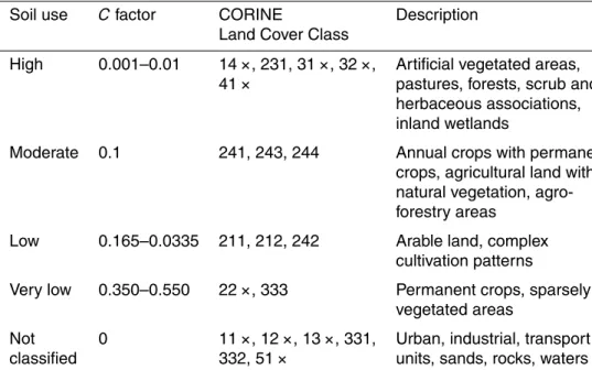
– Cfactor
Cis the unitless cover and management factor. In this studyC(Fig. 2f) has been determined on the base of CORINE Land Cover 2006 (Table 2), as described by
5
Cebecauer et al., 2004.
– LS factor
LS is the unitless slope length and steepness factor (Fig. 2g), which is mainly based on the cell’s slope and contributing area; LS factor has been calculated using data from basin DEM. The calibration of model parameters has led to the
10
use of the equation proposed by Moore and Burch (1986), whereAS is the area of plot cell per unit width (25 m), andβis the cell slope, computed from the basin DEM.
– P factor
P is the support practice factor, accounting for the effect of rehabilitation
treat-15
ments as well as for other features, like roads, streams or railways, or also changes in soil use hampering natural runoff and erosion path. The P factor is unitless and ranges from 0 to 1, depending on the type of erosion soil protection strategy.P factor has been properly determined in each one scenario.
4 Study scenarios
20
HESSD
9, 10877–10916, 2012Modeling postfire water erosion mitigation strategies
M. C. Rulli et al.
Title Page
Abstract Introduction
Conclusions References
Tables Figures
◭ ◮
◭ ◮
Back Close
Full Screen / Esc
Printer-friendly Version Interactive Discussion
Discussion
P
a
per
|
Dis
cussion
P
a
per
|
Discussion
P
a
per
|
Discussio
n
P
a
per
|
1. The first scenario assesses soil loss at basin scale in natural (unburned) condi-tions. In this scenario the conservation practices factorP was set equal to 1 all over the basin, except for paved roads, railways and bare surface whereP factor is set to 0, due to the lack of information on particular conservation practices for the study basin, the other RUSLE parameters have been evaluated as described
5
in materials and methods section.
2. The second scenario analyzes fire effect on soil losses. During the summer 2009 a forest fire burned about 47 km2of the study area, Fig. 1 reports.
In burned area fire effects on soil characteristics have been mimed by changing the C factor, soil drainage capacity, and soil organic matter content. Fire, in fact,
10
induces both a increase in soil aggregation leading to an increase in bulk density and soil compaction and a decrease of soil cohesiveness (Andreu et al., 2001). Moreover, the combustion of the organic matter can lead to the formation of a soil hydrophobic layer affecting soil hydrologic properties (De Bano, 2000).
Changing of conservation factorCin burned areas has been suggested by several
15
authors. Terranova et al. (2009) assumedCequal to 0.2, 0.05, 0.01 correspond-ing to high, medium or low burn severity for burned area in Calabria region (Italy) having Mediterranean characteristics like the Rio Mannu basin. Another usually adopted hypothesis is to setCequal to 1 for areas with a percentage cover lower than 15 %. In Slovakia, a study on soil erosion assessment setC factor ranging
20
0.35–0.55 to areas classified as “burnt areas” in Corine Land Cover map (Cebe-cauer et al., 2004). Larsen et al. (2007) assigned to C factor on burned areas having maximum of 0.33 and mean of 0.2.
For Rio Mannu basin burned area C factor was set equal to 0.2.
Post fire organic matter decrease has been simulated by considering burned
ar-25
HESSD
9, 10877–10916, 2012Modeling postfire water erosion mitigation strategies
M. C. Rulli et al.
Title Page
Abstract Introduction
Conclusions References
Tables Figures
◭ ◮
◭ ◮
Back Close
Full Screen / Esc
Printer-friendly Version Interactive Discussion
Discussion
P
a
per
|
Dis
cussion
P
a
per
|
Discussion
P
a
per
|
Discussio
n
P
a
per
|
3. The third scenario analyses the effects of rehabilitation treatments like ploughing or tilling on crop burned areas. The partial restoration of soils drainage capac-ity due to ploughing or tilling has been reproduced by assigning to under treat-ment burned area a one level lower drainage class then natural condition drainage class.
5
4. The fourth scenario studies the mulching rehabilitation practice. Straw mulch is considered one of the more cost-effective stabilization treatments in reducing post-fire erosion. Besides, wood mulches provide greater resistance to wind ero-sion than straw mulch and also they are more decay resistant than hydromulch (Robichaud et al., 2010).
10
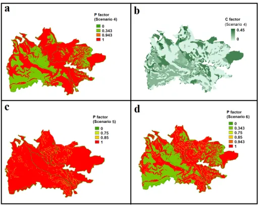
In this study, both straw and wood mulching on burned forested areas have been considered. In particular gentle slopes (slope<30◦) have been treated with straw mulching and steeper slopes (30–50 %) with wood chip mulching. The treatment has been applied on about 45 % of the burned slopes. Mulching effect on soil has been mimed by changing RUSLE parametersP andC. According to Fern `andez
15
et al. (2010)P =0.343 has been used for straw mulching on slopes <30 % and
P =0.943 for wood chip mulch on slopes up to 50 % (Fig. 3a). In addition, the effect of seeding and regrowth of vegetation on soil erosion have been described through C factor. It was set equal to 0.13 corresponding to the mean value ofC
on the burned area prior the fire occurrence (Fig. 3b).
20
5. The fifth scenario analyses the effectiveness in capturing soil losses by erosion barriers or trenches on arable land. Barriers at the distance of 50 m along the contour lines were placed on crop land. This treatment is applied to a share of 35 % of the burned area. Barriers application as rehabilitation treatments is usu-ally modeled by modifying RUSLE P factor. Wischmeier and Smith (1978) and
25
later Terranova et al. (2009) propose aP factor of 0.2 for reverse bench terraces. Myronidis et al. (2009) distinguishedP factor for treatments and slope. They set
HESSD
9, 10877–10916, 2012Modeling postfire water erosion mitigation strategies
M. C. Rulli et al.
Title Page
Abstract Introduction
Conclusions References
Tables Figures
◭ ◮
◭ ◮
Back Close
Full Screen / Esc
Printer-friendly Version Interactive Discussion
Discussion
P
a
per
|
Dis
cussion
P
a
per
|
Discussion
P
a
per
|
Discussio
n
P
a
per
|
branch piles and woodboards or log terraces on steeper slopes (30 % to 50 %), andP =1 for slopes greater than 50 %.
In this study, theP factor values introduced by Myronidis et al. (2009) were used (Fig. 3c).
6. The sixth scenario considers the combination of all rehabilitation practices
de-5
scribed in the previous scenarios 3, 4 and 5. In particular the effectiveness of the treatments combination is tested by assuming the following pattern: tilling all over the burned area, mulching on woodland and erosion barriers or trenches on arable land. TheP factor has been set accordingly as showed in Fig. 3d, and the
Cfactor is the same as in scenario 4 (Fig. 2f).
10
5 Results
Table 3 shows the summary of results where simulated soil loss main statistics, corre-sponding to the six studied scenarios, are reported. In particular, the statistical analy-sis of erosion in natural condition (scenario 1) has been reported both for Rio Mannu basin and for the sub-area subjected to treatments (47 km2). Soil losses corresponding
15
to basin sub-area under treatments have been analyzed for scenarios 2–6.
5.1 Scenario 1: pre-fire estimated erosion
Mean soil loss calculated over the whole basin amounts to 1.9 t ha−1yr−1. Zonal statis-tic underlines significant differences in soil losses among areas having different soil use. Mean soil loss ranges from 0.12 t ha−1yr−1 on land classified as pasture, to 4.5–
20
5.6 t ha−1yr−1 on areas cultivated with vines or olive trees, up to 20.5 t ha−1yr−1in ar-eas with little or no vegetation cover. In these arar-eas, maximum soil loss estimations is 69 t ha−1yr−1, which is a quite high value due to the combination of the steepest slope very high values of RUSLE factors, The analysis shows values greater than 30 t ha−1yr−1 occurring in very few cells of the basin (0.24 %). In addition, the 99th
HESSD
9, 10877–10916, 2012Modeling postfire water erosion mitigation strategies
M. C. Rulli et al.
Title Page
Abstract Introduction
Conclusions References
Tables Figures
◭ ◮
◭ ◮
Back Close
Full Screen / Esc
Printer-friendly Version Interactive Discussion
Discussion
P
a
per
|
Dis
cussion
P
a
per
|
Discussion
P
a
per
|
Discussio
n
P
a
per
|
percentile of the whole area soil loss is 19.4 t ha−1yr−1, and 90 % is 5.05 t ha−1yr−1 (Fig. 4).
5.2 Scenario 2: fire effect on erosion
Soil losses in the burned areas are considerably higher then in not fire affected condi-tion being the mean soil loss 7.18 t ha−1yr−1, while maximum value is 45.1 t ha−1yr−1.
5
The 99th percentile lies at 24.4 t ha−1yr−1, and 90th percentile at 16.4 t ha−1yr−1. In the first scenario, soil loss within the same area reach a mean value of only 2.01 t ha−1yr−1, and a maximum of 41.5 t ha−1yr−1. These values show that fire affect erosion by in-creasing mean soil loss by more than 150 % (Fig. 5a). Again, only a very small per-centage of cells (0.20 %) have extremely high erosion values, above 30 t ha−1yr−1.
10
5.3 Scenario 3: soil loss after tilling/ploughing
Amelioration of the burned soil drainage capacity by ploughing or tilling is modeled to achieve some mitigation of erosion. Nevertheless, on burned areas, after treatment maximum soil loss is around 47 t ha−1yr−1, mean value decreases to 6.15 t ha−1yr−1, while 99 % of soil loss lies under 21.2 t ha−1yr−1, and 90 % under 14.1 t ha−1yr−1
15
(Fig. 5b).
5.4 Scenario 4: soil loss after mulching on woodland areas
The mulching treatment reduces soil loss considerably more than the previous treat-ment: although maximum soil loss calculated is 60.1 t ha−1yr−1, 99 % of cells show soil loss lesser than 18.0 t ha−1yr−1, and 90 % lesser than 5.4 t ha−1yr−1; mean value is
20
HESSD
9, 10877–10916, 2012Modeling postfire water erosion mitigation strategies
M. C. Rulli et al.
Title Page
Abstract Introduction
Conclusions References
Tables Figures
◭ ◮
◭ ◮
Back Close
Full Screen / Esc
Printer-friendly Version Interactive Discussion
Discussion
P
a
per
|
Dis
cussion
P
a
per
|
Discussion
P
a
per
|
Discussio
n
P
a
per
|
5.5 Scenario 5: soil loss with barriers on crops land
Barriers on arable land reduce soil loss less than mulching, but a little bit more than ploughing. Maximum soil loss on burned areas states at 45.1 t ha−1yr−1, and mean value is 6.71 t ha−1yr−1, 99 % lies under 24.1 t ha−1yr−1, 90 % under 15.9 t ha−1yr−1. All these values are very close to those obtained in scenario 3 (Fig. 5d).
5
5.6 Scenario 6: soil loss with application of all rehabilitation treatments on burned areas
Combination of three different rehabilitation treatments on burned area further im-proves soil losses’ reduction. Mean soil loss estimated over the Rio Mannu basin is 1.50 t ha−1yr−1, maximum soil loss is 52.7 t ha−1yr−1; 99 % of cells have soil lesser
10
tahn 15.1 t ha−1yr−1, 90 % lesser than 4.5 t ha−1yr−1(Fig. 5e).
6 Discussion
Measured mean erosion in Mediterranean Europe amounts to 1.3 t ha−1yr−1 (Cerdan et al., 2010). In Italy forty reservoirs sediment deposition dataset, acquired by direct sonar sub-bottom profiler measurements or derived from estimates and measures
car-15
ried by Italian Electricity Power Company during reservoirs dredging (Van Rompaey et al., 2005), reports mean erosion of about 2.3 t ha−1yr−1. Concerning Sardinia re-gion, these measurements show mean erosion of about 4.0 t ha−1yr−1. Measurements in Mulargia and Flumendosa basins, located south of island, show a mean erosion of 5.56 t ha−1yr−1 (respectively 10.3 t ha−1yr−1 and 0.9 t ha−1yr−1) (Van Rompaey et al.,
20
2003). Lower values are also recorded in Bonassai (SS), south-west of the studied area, where mean erosion rates lie around 0.025 t ha−1yr−1 (Acutis et al., 1996), and a field study carried out in Pattada (SS) reports a mean soil loss of 0.034 t ha−1yr−1 (0.049 t ha−1yr−1 on ploughed land, 0.048 t ha−1yr−1 on grassland, 0.033 t ha−1yr−1 on natural pasture, 0.014 t ha−1yr−1 on burned pasture, 0.025 t ha−1yr−1 on slashed
HESSD
9, 10877–10916, 2012Modeling postfire water erosion mitigation strategies
M. C. Rulli et al.
Title Page
Abstract Introduction
Conclusions References
Tables Figures
◭ ◮
◭ ◮
Back Close
Full Screen / Esc
Printer-friendly Version Interactive Discussion
Discussion
P
a
per
|
Dis
cussion
P
a
per
|
Discussion
P
a
per
|
Discussio
n
P
a
per
|
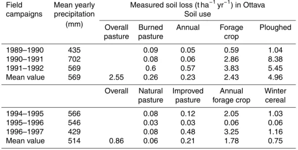
bushland) (Rivoira et al., 1989); the authors themselves, though, note that these val-ues have to be considered quite low for Sardinian conditions. Two field campaigns were carried out in Ottava (SS), a field site in the northern part of the Rio Mannu basin (Porqueddu and Roggero, 1994; Porqueddu et al., 2001). During first experi-ment, lasted from 1989 to 1991, soil loss on several soil uses (permanent pasture,
5
annual forage crop, and continuously ploughed soil) were measured. The second ex-periment took place from 1994 to 1997, assessing soil loss data for four common crops of the Sardinian hilly areas which are natural pasture, improved pasture, annual forage crop and winter cereal. During the two experimental campaigns mean soil loss of, re-spectively 2.55 and 0.86 t ha−1yr−1were measured. Table 4 reports soil losses for each
10
soil use and for each experiment.
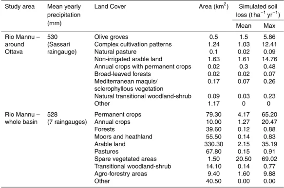
Our simulation results for the scenario 1, reported in detail in Table 5, show for Rio Mannu basin mean soil losses of 1.9 t ha−1yr−1, that lies in the range of measured erosion data in Sardinia, South Italy and the Mediterranean Europe. Model results have been further compared with measurements of Ottava, the field site in the
north-15
ern part of the Rio Mannu basin. Peak simulated soil losses in Rio Mannu basin cor-responds to areas with spare vegetation, olive groves or vineyards. For these land use classes, zonal statistics provide soil losses of 55.4 t ha−1yr−1, 13.72 t ha−1yr−1and 10.9 t ha−1yr−1, respectively. Indeed, peak values of 55.4 t ha−1yr−1 occur in very few cells (0.2 %) where the combination of steep slopes, high LS factor andCfactor lead to
20
such maxima. Cerdan et al. (2010), during their field experiments in Mediterranean environment, observed erosion on bare soil of 9.05 t ha−1yr−1 and on vineyards of 8.62 t ha−1yr−1. Model performances in reproducing soil losses in selected soil uses as pasture, forage crops, cereals have been assessed by comparison with Ottava field campaigns measurements. Model simulations have been carried out both for a sub
25
HESSD
9, 10877–10916, 2012Modeling postfire water erosion mitigation strategies
M. C. Rulli et al.
Title Page
Abstract Introduction
Conclusions References
Tables Figures
◭ ◮
◭ ◮
Back Close
Full Screen / Esc
Printer-friendly Version Interactive Discussion
Discussion
P
a
per
|
Dis
cussion
P
a
per
|
Discussion
P
a
per
|
Discussio
n
P
a
per
|
spatialized formed the model input. Results, reported in detail in Table 6, show a good agreement with measurements especially among sub area simulations and second ex-periment results reporting mean erosion of 1.08 and 0.86 t ha−1yr−1, respectively. The model, despite its simplicity, adequately reproduces observed soil loss for the different land uses.
5
Scenario 2 results, assuming post-fire conditions, show mean soil loss of 7.18 t ha−1yr−1 on the burned area corresponding to an increase of almost +260 % compared to pre fire condition on the same area (mean soil losses equal to 2.01 t ha−1yr−1).
Before commenting this increase, it should be kept in mind that the variability of
mea-10
sured data concerning post fire erosion is unavoidable, depending on several factors, such as, among others, site specific characteristics, fire severity, rainfall intensity and total.
The few measured data on burned plots in Sardinia are those from Rio S. Lucia (Vacca et al., 2001), from Pattada (Rivoira et al., 1989) and from Ottava (Porqueddu
15
and Roggero, 1994). Field experiments in S. Lucia basin report mean yearly soil loss on burned pasture lands of 0.06 t ha−1, less than soil loss on slopes covered with shrub (0.11 t ha−1) and with Eucalyptus (0.23 t ha−1); in Pattada, the erosion on burned slope is 0.014 t ha−1yr−1, less than on ploughed land (0.049 t ha−1yr−1), grass-land (0.048 t ha−1yr−1), natural pasture (0.033 t ha−1yr−1) and shrub (0.025 t ha−1yr−1);
20
in Ottava, soil losses of 0.23 t ha−1yr−1have been observed on burned plot, as shown in Table 4. In all three cases, the erosion values on burned soil do not significantly dif-fer from values on unburned slopes. The authors themselves underline that such low values are probably not representing of the not controlled wild fire impact on soil losses and they are probably due to the very low severity of fire.
25
HESSD
9, 10877–10916, 2012Modeling postfire water erosion mitigation strategies
M. C. Rulli et al.
Title Page
Abstract Introduction
Conclusions References
Tables Figures
◭ ◮
◭ ◮
Back Close
Full Screen / Esc
Printer-friendly Version Interactive Discussion
Discussion
P
a
per
|
Dis
cussion
P
a
per
|
Discussion
P
a
per
|
Discussio
n
P
a
per
|
12.4 t ha−1 on high severity burned plot, and on average 4.9 t ha−1 on two low severity burned plots, whereas the control plot erosion in the same year was 1.96 t ha−1. These values show an increase in erosion of 150 % passing from unburned to low severity burned, and of 530 % from unburned to high severity burned plots. Moreover, mea-surements after several wildfires in the Colorado Front Range showed soil losses of
5
0.05 t ha−1yr−1, of 2 t ha−1yr−1 and of 2–10 t ha−1yr−1, respectively in areas burnt by low, medium and high severity fire (Benavides-Solorio and Mac Donald, 2005), so rep-resenting an increase of more than two orders of magnitude from low severity to high severity fire. Further, mean post-fire erosion estimations in Greece report an increase of 570 % (Vafeidis et al., 2006) in post fire erosion, and plot scale erosion rates after
10
rainfall simulations in the Branega catchment in Liguria (Italy) show ratios of 143 to 162 between a recently burned plot and a long unburned one, depending on soil moisture conditions before rainfall (Rulli et al., 2006).
According, simulation results in this study highlight the impact of fire in enhancing soil losses so showing the increase of maximum and mean erosion in the burned areas,
15
as well as the increasing of the percentage of basin area affected by large soil losses (high level of erosion) (Tables 3 and 7).
The successive three scenarios investigate the effect of some post fire erosion miti-gation treatments.
Scenario 3 mimics the breaking up of the hydrophobic layer by acting on the soil’s
20
drainage capacity. This treatment does not achieve significant reduction on soil erosion: mean soil loss on burned area is only 14 % less than in the scenario with burned soils (Table 3).
Mulching rehabilitation treatment on woodland (Scenario 4) shows a decreasing of 75 % in mean soil loss calculated over the whole burned area. The decrease in
ero-25
sion is such that estimated soil loss becomes slightly lower than in the first scenario (Table 3).
HESSD
9, 10877–10916, 2012Modeling postfire water erosion mitigation strategies
M. C. Rulli et al.
Title Page
Abstract Introduction
Conclusions References
Tables Figures
◭ ◮
◭ ◮
Back Close
Full Screen / Esc
Printer-friendly Version Interactive Discussion
Discussion
P
a
per
|
Dis
cussion
P
a
per
|
Discussion
P
a
per
|
Discussio
n
P
a
per
|
to 27 %. During the first year after a fire in Galicia Fern `andez et al. (2011) measured that straw mulch application with 80 % soil cover produced a reduction of sediment production of 66 % compared with the control plots, while chip mulch application with 45 % soil cover produced almost no reduction of sediment yield (33 Mg ha−1after treat-ment, 35 Mg ha−1 in the control plot). In our exercise rehabilitation treatment has been
5
applied on about 45 % of the burned slopes, so that our results agree with the literature measured data.
Scenario 5, consisting on applying barriers on crop land, leads to a decrease of only 6.5 % in mean soil losses on the whole burned area, by applying the treatment to a share of 35 %. Robichaud (2006) found a reduction in soil losses due to the
pres-10
ence of barriers (contour felled logs) of about 20–50 % for mid- to high-intensity rainfall events. Accordingly, Fern `andez et al. (2011) observed that the initial mean efficiency of cut-shrub barriers in retaining sediment (58 %) decreased to 15 % four months af-ter treatment. Measurements in burned plots treated with different barrier types (Ro-bichaud et al., 2007) showed better performance for contour-felled logs and straw
wat-15
tle treatment while contour trench showed no significant erosion mitigation effect. Finally, scenario 6, studying the effects of the combination of the three different re-habilitation treatments, shows mean soil loss lower than the post fire scenario (79 %) and also the natural scenario (20 %) (Table 3).
Besides mean and maximum estimated soil losses, an interesting feature to observe
20
for the six scenarios is the erosion levels distribution on the study area. In the present study four erosion levels have been defined: low, medium, high, very high having, re-spectively soil loss lesser than 0.5 t ha−1yr−1; comprised between 0.5 and 2 t ha−1yr−1; comprised between 2 and 8 t ha−1yr−1; greater than 8 t ha−1yr−1.
In the first scenario, the area of the Rio Mannu basin classified at very high erosion
25
level is 5 % of total area, while 53 % of the basin presents low erosion level. High and moderate erosion levels cover 20 % and 22 % of the area, respectively.
HESSD
9, 10877–10916, 2012Modeling postfire water erosion mitigation strategies
M. C. Rulli et al.
Title Page
Abstract Introduction
Conclusions References
Tables Figures
◭ ◮
◭ ◮
Back Close
Full Screen / Esc
Printer-friendly Version Interactive Discussion
Discussion
P
a
per
|
Dis
cussion
P
a
per
|
Discussion
P
a
per
|
Discussio
n
P
a
per
|
In scenario 2, the area having very high level raises to 37 %, while low erosion level decreases to 11 % of the area. Also high level shows a considerable increase to 41 % of the total burned area, while moderate class remains around 12 % (Fig. 6b).
In the third scenario, where no significant reduction in term of mean or maximum soil loss estimations have been observed compared with scenario 2, there is
neverthe-5
less a remarkable decrease in the percentage of area affected by very high soil loss, which is 30 %, while high, moderate, and low are, respectively the 41 %, 12 % and 11 % (Fig. 6c).
Scenario 4, already reporting a significant contribution for soil loss mitigation in term of mean or maximum soil loss at treated area scale, shows that the effect of treatment
10
in reducing soil loss is made more evident by the distribution of erosion levels over the area: only 6 % of area presents very high erosion level, 15 % high, 21 % moderate and as much as 58 % low (Fig. 6d).
In the fifth scenario, very high erosion affects 39 % of the area, and 16 % of it is classified as low in erosion level. This means an increase in low erosion zones and
15
a decrease in very high erosion zones, while high or moderate erosion affects the same percentage of area as in the second scenario. As noticed before, the erosion barriers performance would be more appreciable if studied with a model for sediment propagation (Fig. 6e).
The last scenario shows that the area presenting low erosion is 62 %, whereas very
20
high erosion occurs on just 4 % of it (Fig. 6f).
A summary of the erosion levels corresponding to the analyzed treatments is re-ported in Table 7.
7 Conclusions
In this paper a simple distributed model based on RUSLE equation has been
pre-25
HESSD
9, 10877–10916, 2012Modeling postfire water erosion mitigation strategies
M. C. Rulli et al.
Title Page
Abstract Introduction
Conclusions References
Tables Figures
◭ ◮
◭ ◮
Back Close
Full Screen / Esc
Printer-friendly Version Interactive Discussion
Discussion
P
a
per
|
Dis
cussion
P
a
per
|
Discussion
P
a
per
|
Discussio
n
P
a
per
|
treatments can be useful to choose the better soil losses mitigation methods, partic-ularly in the Mediterranean area experiencing every year a large number of wildfires most of them at the interface with urban area.
Model results compared with the available field measurements and the detailed anal-ysis of the treatments scenarios show distributed RUSLE capacity to be a simple and
5
useful model for correctly reproduce soil losses in Rio Mannu basin and also for select-ing the most appropriate treatment related to site characteristics. Nevertheless, a dis-tributed model capable of representing sediment dynamic could better assess the effi -ciency of mitigation strategies, especially for erosion barriers.
Results showing changes both in soil losses total and on erosion levels among the six
10
scenarios demonstrates the effectiveness of mitigation treatments on the Rio Mannu basin burned area, as well as the importance of choosing the most appropriate erosion mitigation strategies related to site characteristics. Choosing how to restore channels and slopes after a wildfire is an important issue, which could be properly dealt with, if more effort would be spent for the collection of field data before and after fires. In fact,
15
most of the existing models, as the RUSLE based model used in this study, try to de-scribe and quantify post-fire erosion considering variables like fire severity, percentage bare soil, rainfall erosivity, soil repellency, despite measures of these are not always available.
In the USA, Burned Area Emergency Rehabilitation (BAER) activities have been
20
established for assessing the need and implementation of post-fire treatments so pro-viding choice of treatments and essential protection (Neary, 2005; Robichaud, 2006). Since any treatment recommendation has to be matched to the specific environmen-tal and climatic conditions of the area, models and parameterizations based on mea-surements made in the USA do not necessarily apply to Sardinian conditions. The
25
HESSD
9, 10877–10916, 2012Modeling postfire water erosion mitigation strategies
M. C. Rulli et al.
Title Page
Abstract Introduction
Conclusions References
Tables Figures
◭ ◮
◭ ◮
Back Close
Full Screen / Esc
Printer-friendly Version Interactive Discussion
Discussion
P
a
per
|
Dis
cussion
P
a
per
|
Discussion
P
a
per
|
Discussio
n
P
a
per
|
Further efforts should therefore be directed to collect field data for the Mediterranean environment.
Accurate estimation of potential soil losses, coupled with evaluation of watershed re-habilitation effectiveness can useful to maintain soil loss and soil renewal rate at equi-librium, which is a critical issue for successful land management. Mitigation strategies
5
of forest fires effects in the Mediterranean areas should be aimed toward sustainable coexistence with forest fires, in terms of both human security and ecological processes.
Acknowledgements. The financial support provided for this work by Regione Sardegna through the project named “methodology and indicators for fire risk assessment in rural-urban interface of Mediterranean environment” (MIUR CRP 2 565) is gratefully acknowledged.
10
References
Acutis, M., Argenti, G., Bersani, L., Bullitta, P., Caredda, S., Cavallero, A., Giordani, C., Grig-nani, C., Pardini, A., Porqueddu, C., Reyneri, A., Roggero, P. P., Sulas, L., Talamucci, P., and Zanchi, C.: Effetti di tipologie di suolo e colture foraggere sulle perdite per ruscellamento di azoto, fosforo e potassio in differenti areali italiani, Riv. Agron., 30, 329–338, 1996.
15
Andreu, V., Imeson, A. C., and Rubio, J. L.: Temporal changes in soil aggregates and water erosion after a wildfire in a Mediterranean pine forest, Catena, 44, 69–84, 2001.
Badia, D. and Marti, C.: Seeding and mulching treatments as conservation measures of two burned soils in the Central Ebro valley, NE Spain, Arid Soil Res. Rehabil., 13, 219–232, 2000.
20
Bautista, S., Robichaud, P. R., and Blad ´e, C.: Post-fire mulching, in: Fire Effects on Soils and Restoration Strategies, edited by: Cerd `a, A. and Robichaud, P. R., Science Publishers, En-field, NH, 353–372, 2009.
Benavides-Solorio, J. D. and Mac Donald, L. H.: Measurement and prediction of postfire erosion at the hillslope scale, Colorado Front Range, Int. J. Wildland Fire, 14, 1–18, 2005.
25
HESSD
9, 10877–10916, 2012Modeling postfire water erosion mitigation strategies
M. C. Rulli et al.
Title Page
Abstract Introduction
Conclusions References
Tables Figures
◭ ◮
◭ ◮
Back Close
Full Screen / Esc
Printer-friendly Version Interactive Discussion
Discussion
P
a
per
|
Dis
cussion
P
a
per
|
Discussion
P
a
per
|
Discussio
n
P
a
per
|
Cebecauer, T., S ´uri, M., Hofierka, J., and Fulajt ´ar, E.: Corine Land Cover in the context of soil erosion assessment at a regional scale, in: Workshop CORINE Land Cover 2000 in Germany and Europe and its use for environmental applications, 20–21 January 2004, Berlin, UBA Texte 04/04, ISSN 0722-186X, 131–137, 2004.
Cerd `a, A.: Changes in overland flow and infiltration after a rangeland fire in Mediterranean
5
scrubland, Hydrol. Process., 12, 1031–1042, 1998.
Cerdan, O., Govers, G., Le Bissonnais, Y., Van Oost, K., Poesen, J., Saby, N., Gobin, A., Vacca, A., Quinton, J., Auerswald, K., Klik, A., Kwaad, F. J. P. M., Raclot, D., Ionita, I., Rej-man, J., Rousseva, S., Muxart, T., Roxo, M. J., and Dostal, T.: Rates and spatial variations of soil erosion in Europe: a study based on erosion plot data, Geomorphology, 122, 167–177,
10
2010.
DeBano, L. F.: The role of fire and soil heating on water repellency in wildland environments: a review, J. Hydrol., 231, 195– 206, 2000.
Doerr, S. H., Shakesby, R. A., and MacDonald, L. H.: Soil water repellency: a key factor in post-fire erosion, in: Fire Effects on Soils and Restoration Strategies, edited by: Cerd `a, A.
15
and Robichaud, P. R., Science Publishers, Enfield, NH, 197–223, 2009.
Elliot, W. J., Hall, D. E., and Graves, S. R., Disturbed WEPP: Forest Service interfaces for the Water Erosion Prediction Project (WEPP) computer model, Moscow, ID, US Department of Agriculture, Forest Service, Rocky Mountain Research Station, available at: http://forest. moscowfsl.wsu.edu/fswepp (last access: August 2012), 2009.
20
Emmerich, W. E. and Cox, J. R.: Changes of surface runoff and sediment production after a repeated rangeland burns’, Soil Sci. Soc. Am. J., 58, 199–203, 1994.
Ferreira, A. J. D., Sande Silva, J., Coelho, C., Boulet, A. K., and Keizer, J. J.: The Portuguese experience in managing fire effects, in: Fire Effects on Soils and Restoration Strategies, edited by: Cerd `a, A. and Robichaud, P. R., Science Publishers, Enfield, NH, 353–372, 2009.
25
Fern ´andez, C., Vega, J. A., and Vieira, D. C. S.: Assessing soil erosion after fire and rehabili-tation treatments in NW Spain: Performance of RUSLE and revised Morgan-Morgan-Finney models, Land Degrad. Dev., 21, 58–67, doi:10.1002/ldr.965, 2010.
Fern ´andez, C., Vega, J. A., Jim ´enez, E., and Fonturbel, M. T.: Effectiveness of three post-fire treatments at reducing soil erosion in Galicia (NW Spain), Int. J. Wildland Fire, 20, 104–114,
30
HESSD
9, 10877–10916, 2012Modeling postfire water erosion mitigation strategies
M. C. Rulli et al.
Title Page
Abstract Introduction
Conclusions References
Tables Figures
◭ ◮
◭ ◮
Back Close
Full Screen / Esc
Printer-friendly Version Interactive Discussion
Discussion
P
a
per
|
Dis
cussion
P
a
per
|
Discussion
P
a
per
|
Discussio
n
P
a
per
|
Flanagan, D. C. and Nearing, M. A.: USDA-Water Erosion Prediction Project: hillslope profile and watershed model documentation, NSERL Report No. 10, USDA-ARS National Soil Ero-sion Research Laboratory, West Lafayette, 1995.
Fox, D. M., Maselli, F., and Carrega, P.: Using SPOT images and field sampling to map burn severity and vegetation factors affecting post forest fire erosion risk, Catena, 75, 326–335,
5
2008.
Ful ´e, P. Z., Ribas, M., Guti ´errez, E., Vallejo, R., and Kaye, M. W.: Forest structure and fire history in an old Pinus nigra forest, Eastern Spain, Forest Ecol. Manag., 255, 1234–1242, 2008.
Garc´ıa Rodr´ıguez, J. L. and Gim ´enez Su ´arez, M. C.: Historical review of topographical factor,
10
LS, of water erosion models, Aqua-LAC, 2, 56–61, 2010.
Grimaldi, S., Nardi, F., Benedetto, F. D., Istanbulluoglu, E., and Bras, R. L.: A physically-based method for removing pits in digital elevation models, Adv. Water. Resour., 30, 2151–2158, doi:10.1016/j.advwatres.2006.11.016, 2007.
Hydrological Annals: Regione Autonoma della Sardegna, Istituto Idrografico di Cagliari, 2009.
15
Keizer, J. J., Doerr, S. H., Malvar, M. C., Prats, S. A., Ferreira, R. S. V., O ˜nate, M. G., Coelho, C. O. A., and Ferreira, A. J. D.: Temporal variation in topsoil water repellency in two recently burnt eucalypt stands in North-Central Portugal, Catena, 74, 192–204, 2008. Larsen, I. J. and Mac Donald, L. H.: Predicting postfire sediment yields at the
hills-lope scale: testing RUSLE and disturbed WEPP, Water Resour. Res., 43, W11412,
20
doi:10.1029/2006WR005560, 2007.
McCool, D. K., Foster, G. R., Renard, K. G., Yoder, D. C., and Weesies, G. A.: The Revised Uni-versal Soil Loss Equation, Department of Defense/Interagency Workshop on Technologies to Address Soil Erosion on Department of Defense Lands, San Antonio, TX, 11–15 June 1995.
25
Moody, J. A., Martin, D. A., Haire, S. L., and Kinner, D. A.: Linking runoff response to burn severity after a wildfire, Hydrol. Process., 22, 2063–2074, doi:10.1002/hyp.6806, 2008. Myronidis, D. I., Emmanouloudis, D. A., Mitsopoulos, I. A., and Riggos, E. E.: Soil erosion
potential after fire and rehabilitation treatments in Greece, Environ. Model. Assess., 15, 239– 250, doi:10.1007/s10666-009-9199-1, 2010.
30
HESSD
9, 10877–10916, 2012Modeling postfire water erosion mitigation strategies
M. C. Rulli et al.
Title Page
Abstract Introduction
Conclusions References
Tables Figures
◭ ◮
◭ ◮
Back Close
Full Screen / Esc
Printer-friendly Version Interactive Discussion
Discussion
P
a
per
|
Dis
cussion
P
a
per
|
Discussion
P
a
per
|
Discussio
n
P
a
per
|
Ollesch, G. and Vacca, A.: Influence of time on measurement results of erosion plot studies, Soil Till Res., 67, 23–39, 2002.
Pausas, J. G. and Paula, S.: Fuel shapes the fire-climate relationship: evidence from Mediter-ranean ecosystems, Global Ecol. Biogeogr., doi:10.1111/j.1466-8238.2012.00769.x, 2012. Pausas, J. G. and Verd ´u, M.: Fire reduces morphospace occupation in plant communities,
5
Ecology, 89, 2181–186, 2008.
Petroselli, A.: LIDAR data and hydrological applications at the basin scale, Gisci. Remote Sens., 49, 139–162, doi:10.2747/1548-1603.49.1.139, 2012.
Porqueddu, C. and Roggero, P. P.: Effect of the agronomic techniques for the improvement of forage production on soil erosion of slopes in a Mediterranean environment (in Italian), Riv.
10
Agron., 28, 364–370, 1994.
Porqueddu, C., Caredda, S., Sulas, L., Farina, R., and Fara, G.: Impact of crop intensification on soil erosion in farming systems based on cereal – annual and permanent forage production in a Sardinian hilly region, Riv. Agron., 35, 45–50, 2001 (in Italian).
Ranzi, R., Than Hung, L., and Rulli, M. C.: A RUSLE approach to model suspended sediment
15
load in the Lo river (Vietnam): effects of reservoirs and land use changes, J. Hydrol., 422, 17–29, 2012.
Regione Autonoma della Sardegna: Water Resources Report, 2006. Regione Autonoma della Sardegna: Fire Service Statistics, 2009.
Robichaud, P. R. and Elliot, W. J.: Protection from erosion following wildfire, Presentation at the
20
2006 ASABE Annual International Meeting, ASABE Paper No. 068009, American Society of Agricultural and Biological Engineers, 2006.
Robichaud, P. R., Beyers, J. L., and Neary, D. G.: Evaluating the effectiveness of postfire reha-bilitation treatments, Gen. Tech. Rep., RMRS-GTR-63, USDA Forest Service, 2000.
Robichaud, P. R., Elliott, W. J., Pierson, F. B., Hall, D. E., Moffet, C. A., and Ashmun, L. E.:
25
Erosion Risk Management Tool (ERMiT) user manual (version 2006-01.18), Gen. Tech. Rep., RMRS-GTR188, USDA Forest Service, 2007a.
Robichaud, P. R., Pierson, F. B., Brown R. E., and Wagenbrenner, J. W.: Measuring eff ective-ness of three postfire hillslope erosion barrier treatments, Western Montana, USA, Hydrol. Process., 22, 159–170, 2007b.
30
HESSD
9, 10877–10916, 2012Modeling postfire water erosion mitigation strategies
M. C. Rulli et al.
Title Page
Abstract Introduction
Conclusions References
Tables Figures
◭ ◮
◭ ◮
Back Close
Full Screen / Esc
Printer-friendly Version Interactive Discussion
Discussion
P
a
per
|
Dis
cussion
P
a
per
|
Discussion
P
a
per
|
Discussio
n
P
a
per
|
erosion mitigation treatments in the Western United States, Int. J. Wildland Fire, 17, 255– 273, 2008.
Robichaud, P. R., Ashmun, L. E., and Sims, B. D.: Post-Fire Treatment Effectiveness for Hills-lope Stabilization, Gen. Tech. Rep., RMRSGTR-240, USDA Forest Service, Rocky Mountain Research Station, 2010.
5
Rivoira, G., Roggero, P. P., and Bullitta, S. M.: Improvement techniques and erosion of hillside pasturelands (in Italian), Riv. Agron., 23, 372–377, 1989.
Rulli, M. C. and Rosso, R.: Modeling catchment erosion after wildfires in the San Gabriel Mountains of Southern California, Geophys. Res. Lett., 32, 1–4, doi:10.1029/2005GL023635, 2005.
10
Rulli, M. C. and Rosso R.: Hydrologic response of upland catchments to wildfires, Adv. Water Resour., 30, 2072–2086, 2007.
Rulli, M. C., Spada, M., Bozzi, S., Bocchiola, D., and Rosso, R.: Rainfall simulations on a fire disturbed Mediterranean area, J. Hydrol., 327, 323–338, 2006.
Shakesby, R. A.: Post-wildfire soil erosion in the Mediterranean: review and future research
15
directions, Earth Sci. Rev., 105, 71–100, 2011.
Soto, B. and Diaz-Fierros, F.: Runoffand soil erosion from areas of burnt scrub: comparison of experimental results with those predicted by the WEPP model, Catena, 31, 257–270, 1998. Soulis, K., Valiantzas, J., and Dercas, N.: Modelling forest fires hydrological impact using
spatio-temporal geographical data, in: International Congress on Environmental Modelling and
Soft-20
ware, Modelling for Environment’s Sake, Fifth Biennial Meeting (iEMSs), Ottawa, Canada, 2010.
Terranova, O., Antronico, L., Coscarelli, R., and Iaquinta, P.: Soil erosion risk scenarios in the Mediterranean environment using RUSLE and GIS: an application model for Calabria (South-ern Italy), Geomorphology, 112, 228–245, 2009.
25
Ursino, N. and Rulli, M. C.: Hydrological minimal model for fire regime assessment in a Mediter-ranean ecosystem, Water Resour. Res., 47, W11526, doi:10.1029/2011WR010758, 2011. Vacca, A., Loddo, S., Ollesch, G., Puddu, R., Serra, G., Tomasi, D., and Aru, A.: Measurement
of runoffand soil erosion in three areas under different land use in Sardinia, Italy, Catena, 40, 69–92, 2000.
30
HESSD
9, 10877–10916, 2012Modeling postfire water erosion mitigation strategies
M. C. Rulli et al.
Title Page
Abstract Introduction
Conclusions References
Tables Figures
◭ ◮
◭ ◮
Back Close
Full Screen / Esc
Printer-friendly Version Interactive Discussion
Discussion
P
a
per
|
Dis
cussion
P
a
per
|
Discussion
P
a
per
|
Discussio
n
P
a
per
|
Van Rompaey, A. J. J., Bazzoffi, P., Jones, R. J. A., Montanarella, L., and Govers, G.: Validation of Soil Erosion Risk Assessments in Italy, in: European Soil Bureau Research Report No. 12, EUR 20676 EN, Office for Official Publications of the European Communities, Luxembourg, 2003.
Van Rompaey, A. J. J., Bazzoffi, P., Jones, R. J. A., and Montanarella, L.: Modeling sediment
5
yields in Italian catchments, Geomorphology, 65, 157–169, 2005.
Wagenbrenner, J. W., Mac Donald, L. H., and Rough, D.: Effectiveness of three post-fire rehabilitation treatments in the Colorado Front Range, Hydrol. Process., 20, 2989–3006, doi:10.1002/HYP.6146, 2006.
Wohlgemuth, P. M., Beyers, J. L., and Hubbert, K. R.: Rehabilitation strategies after fire: the
10
California, USA experience, in: Fire effects on soils and restoration strategies, edited by: Cerd `a, A. and Robichaud, P. R., Science Publishers, Enfield, NH, 511–535, 2009.
Wischmeier, W. H. and Smith, D. D.: Predicting rainfall erosion losses, in: Agriculture Handbook, 537, Agriculture Research Service, US Department of Agriculture, Washington, DC, USA, 1978.
HESSD
9, 10877–10916, 2012Modeling postfire water erosion mitigation strategies
M. C. Rulli et al.
Title Page
Abstract Introduction
Conclusions References
Tables Figures
◭ ◮
◭ ◮
Back Close
Full Screen / Esc
Printer-friendly Version Interactive Discussion
Discussion
P
a
per
|
Dis
cussion
P
a
per
|
Discussion
P
a
per
|
Discussio
n
P
a
per
|
Table 1.RUSLE input value classification after pedological map of Sardinia.
Drainage Excessive Good Moderate Imperfect Slow Very Other
class slow
RUSLE input values 1 2 3 4 5 6 7
Fertility Low Medium High Very Other
class high
RUSLE input values 1 2 3 4 5
Texture Coarse Medium Medium Fine Very Other
class fine fine
RUSLE input values
Texture 1 2 3 4 5 6
Clay % 0.079 0.176 0.170 0.460 0.733 0 Silt % 0.136 0.404 0.760 0.270 0.133 0 Sand % 0.786 0.420 0.070 0.270 0.133 0
HESSD
9, 10877–10916, 2012Modeling postfire water erosion mitigation strategies
M. C. Rulli et al.
Title Page
Abstract Introduction
Conclusions References
Tables Figures
◭ ◮
◭ ◮
Back Close
Full Screen / Esc
Printer-friendly Version Interactive Discussion
Discussion
P
a
per
|
Dis
cussion
P
a
per
|
Discussion
P
a
per
|
Discussio
n
P
a
per
|
Table 2.Cfactor assignment after CORINE Land Cover class 2006.
Soil use Cfactor CORINE Description Land Cover Class
High 0.001–0.01 14×, 231, 31×, 32×, Artificial vegetated areas, 41× pastures, forests, scrub and
herbaceous associations, inland wetlands
Moderate 0.1 241, 243, 244 Annual crops with permanent crops, agricultural land with natural vegetation, agro-forestry areas
Low 0.165–0.0335 211, 212, 242 Arable land, complex cultivation patterns
Very low 0.350–0.550 22×, 333 Permanent crops, sparsely vegetated areas
HESSD
9, 10877–10916, 2012Modeling postfire water erosion mitigation strategies
M. C. Rulli et al.
Title Page
Abstract Introduction
Conclusions References
Tables Figures
◭ ◮
◭ ◮
Back Close
Full Screen / Esc
Printer-friendly Version Interactive Discussion
Discussion
P
a
per
|
Dis
cussion
P
a
per
|
Discussion
P
a
per
|
Discussio
n
P
a
per
|
Table 3.Simulated soil loss corresponding to the six studied scenarios. Erosion in natural con-dition (scenario 1) has been reported both for Rio Mannu basin and for the sub-area subjected to treatments in scenarios 2–6. Soil losses corresponding to basin sub-area under treatments are reported in scenarios 2–6.
Simulated soil loss (t ha−1yr−1) Mean 99th percentile 90th percentile
Scenario 1 (basin area) 1.90 19.4 5.1
Scenario 1 (sub-area) 2.01 18.6 5.6
Scenario 2 (sub-area) 7.18 24.2 16.4
Scenario 3 (sub-area) 6.15 21.2 14.1
Scenario 4 (sub-area) 1.78 18.0 5.4
Scenario 5 (sub-area) 6.71 24.1 15.9