REGIONAL CHANGE IN THE ALGARVE:
A GEOGRAPHIC INFORMATION SYSTEMS APPROACH
by
Eric Moreira de Noronha Vaz
Dissertation submitted to the Instituto Superior de Estatística e Gestão de Informação
da Universidade Nova de Lisboa in partial fulfillment of the requirements for the
Degree of
Doutor em Gestão de Informação
–
Sistemas de Informação Geográfica
(Doctor of Philosophy in Information Management
–
Geographic Information
Systems)
Instituto Superior de Estatística e Gestão de Informação
da
Universidade Nova de Lisboa
REGIONAL CHANGE IN THE ALGARVE:
A GEOGRAPHIC INFORMATION SYSTEMS APPROACH
by
Eric Moreira de Noronha Vaz
Dissertation supervised by
Professor Marco Painho Professor Peter Nijkamp
Instituto Superior de Estatística e Gestão de Informação
da
Universidade Nova de Lisboa
i
DEDICATION
To joy, laughter, music, and bliss. And most of all, to the two women in my life: my mother and my
iii
ACKNOWLEDGMENTS
This dissertation would have been impossible without the help from so many. My deepest gratitude goes to my advisors, Professor Marco Painho and Professor Peter Nijkamp, who gave me the freedom to think and work enthusiastically on all of my ideas. I am also thankful:
In Cambridge, MA. - Massachusetts Institute of Technology (―If you don‟t like the weather, just wait a minute‖): I would like to thank Professor Carlo Ratti and Filippo for having received me at MIT‘s Senseable City Lab and the rest
of the team for their support.
In Vienna - Wirtschaftsuniversität Wien (―Wien! Mit Freunden, Nusstorten und Oper!‖): I would like to thank Professor Manfred Fischer, for his always continuing support and friendship which I much cherish, and also my friends Tamás, Petra, Alfred, and Sascha.
In Brighton, UK – University of Sussex (“The best Summer School ever.”): Sigrid and Andy for having organized a
fantastic and very inspiring Summer School, where I‘ve made good friends: Matteo, Giacomo, Scott, Doan, Pere, Cristina, Tarik, Rafa, Mari and Anna. In the London School of Economics I would like to thank the interesting experience at the Regional and Urban Planning Studies Masters, especially Professor Nancy Holman for all her support.
In Amsterdam –Free University of Amsterdam (―travelling on the canals of always exciting projects!”): My gratitude goes out to Elfie and Jenni, for always supporting me when necessary. Also, Jasper, Henk and Eric and my friend Eveline. Especial thanks to Mrs. Ellman, for her incredible English language editing skills and the detailed and very constructive corrections in so many of my papers.
In Faro – University of the Algarve (“não há ar que cheire melhor do que o do nosso Algarve.”): I would like to thank Professor Efigénio Rebelo, who believed in my aptitudes as a lecturer for the Universidade do Algarve (the corkscrew still opens many bottles of wine) and my friends at the CIEO: Marlene, Julieta, Andrés and Sílvia.
In Lisbon – Universidade Nova de Lisboa, ISEGI (“Lisboa, uma das cidades mais bonitos da Europa!”): André Oliveira, André Barriguinha and my Masters advisors, Professor Pedro Cabral and Professor Mário Caetano, who taught me in the very beginning the tools of the trade. Also my cordial gratitude to the best academic staff in the world: Gisela and Andreia.
My friends: Janete, Bruno, Oscar, João, Eva, Pedro and Sandra Henriques, Jay and Sebastian (may this work also be readable by my godson in two decades: Miguel Maria).
I would also like to thank the Portuguese Science Foundation and Professor João Sentieiro, for having thought me a very valuable lesson: speak up, when you have to - but with understanding.
iv
The following research of this dissertation was funded by the following institutions:
- Fundação para a Ciência e Tecnologia (FCT) – SFRH/BD/44152/2008
v
ABSTRACT
The debate on sustainable development has led to an increasing interest covering the effects of the human beings on the natural environment. The development of information and communication technologies (ICT) allowed a better analysis of the drivers of environmental change. With the increase of ICT, especially related to monitoring of sustainable choices, methodologies for analysis of regional and local impact have made a significant contribution to the development of regional strategies at a policy level, but also contributed to the development of regional sciences. One of the main issues has been addressed by the analysis of carrying capacity and availability of scarce resources, resulting from a growing demand, leading to loss of vulnerable natural and historical areas. Much of the work of regional sciences has had a direct relation to space, due to the nature of socio-economic data. This thesis offers an integrated spatial assessment of the results of regional change brought by socio-economic growth. The Algarve region in Portugal is used as a laboratory to understand the current pressures and attempts to provide a framework for the future of socio-economic growth in the region and a systematic analysis of current pressures. While urban sprawl due to increasing tourist activity is an increasing concern, spatial analysis is used as an insightful tool for foresight of future change. Having considered that urban growth is a direct consequence of economic growth our research addresses the consequences of urban sprawl in the coastal region of the Algarve. By building up predictive tools for complex spatial system analysis, cellular automata are used to forecast future urban expansion in the region. The relationship of tourism to urban change is measured to assess what are true costs of tourism for the region. Tourism is then analysed within the duality of socio-economic pressures defining weak and strong sustainability. An integrated strategy considering the historical heritage of the Algarve is offered as a more interesting alternative to the current exploration of the marine environment. Thus, the dissertation expands on the usage of spatial analysis as tools to emphasize the importance of monitoring regional change in coastal environments from a socio-economic perspective. Geographic Information Systems are expressed as ubiquitous systems with unique properties to measure change and to offer relevant solutions for better decision making at local and regional level. An important asset of those tools in the context of information management is further explored in the capabilities of comparing results through spatial data manipulation and visualization of alternative futures for regional development.
vi
RESUMO
O debate sobre desenvolvimento sustentável tem levado a um crescente interesse nos efeitos do ser humano sobre o ambiente natural. O desenvolvimento das tecnologias de informação e comunicação (TIC) tem vindo a permitir uma análise mais cuidada das determinantes de alteração ambiental. Com o incremento das TIC, especialmente em relação à monitorização de escolhas sustentáveis, as metodologias para análise regional e local têm vindo a dar uma contribuição significativa para o desenvolvimento de estratégias regionais a nível das políticas públicas, tanto quanto têm contribuído para um desenvolvimento das ciências regionais. Uma das principais questões abordadas no discurso teórico é a análise da capacidade de carga de recursos que escasseiam de forma crescente como fruto de uma crescente procura e, consequentemente, levando à perca de importantes áreas naturais e históricas. Esta dissertação oferece uma análise espacial integrada dos resultados de mudança regional devido ao crescimento socioeconómico. A região do Algarve em Portugal é utilizada como laboratório na compreensão das actuais pressões, visto proporcionar um contexto particularmente adequado à análise de futuros impactos regionais através de análise sistemática. A crescente actividade turística aumenta a preocupação sobre o crescimento urbano e a análise espacial é utilizada para compreender as alterações futuras deste sector. Tendo-se considerado que o crescimento urbano é uma consequência directa do crescimento económico, o paradigma aborda as consequências do crescimento urbano em zonas litorais. A relação do turismo com a mudança urbana é medida para conseguir compreender melhor o verdadeiro custo do turismo. Assim, o turismo é analisado sob a perspectiva dual de pressões socioeconómicas e o nível de sustentabilidade, mais ou menos forte que ele impõe. Uma estratégia integrada considerando a importância da herança histórico-arqueologica do Algarve é ainda utilizada para oferecer uma visão alternativa sobre a exploração do ambiente lagunar litoral. Assim sendo, esta dissertação pretende expandir conhecimento na aplicação de ferramentas de análise espacial para observação de dinâmicas regionais e sua importância na compreensão das consequências em ambientes costeiros de variáveis socioeconómicos. Os Sistemas de Informação Geográficos são utilizados como sistemas ubíquos com capacidades únicas de medir quantitativamente as mudanças regionais, oferecendo soluções para uma melhor tomada de decisão, até a nível local. Ainda um importante contributo é a utilização da gestão de informação combinada à utilização e manipulação de dados espaciais para visualização de cenários alternativos para múltiplas escolhas, mais ou menos prováveis, de crescimento regional.
vii
TABLE OF CONTENTS
DEDICATION ... i
ACKNOWLEDGMENTS ... iii
ABSTRACT ... v
RESUMO ... vi
TABLE OF CONTENTS ... vii
LIST OF TABLES ... ix
LIST OF FIGURES ... x
Chapter 1 - Introduction ... 1
1.1. Justification ... 1
1.2. Methodological Tools for GIS and Spatial Analysis ... 3
1.3. Applied Methodology ... 4
1.4. Assumptions ... 8
1.5. Objectives ... 9
1.4. Hypothesis ... 12
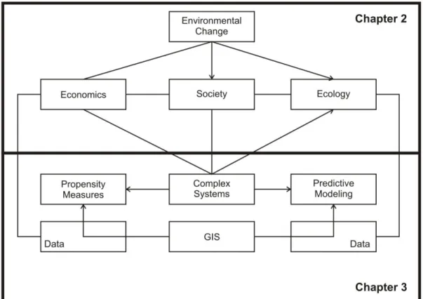
Chapter 2 –Economic, Social and Natural Factors in Regional Change ... 15
2.1. Complex Systems and Scenarios ... 15
2.2. Economics and Environmental Change ... 19
2.3. Society and Environmental Change ... 25
Chapter 3 – Material and Methods: GIS and Spatial Analysis to Evaluate Environmental Impact Assessments in the Algarve ... 33
Chapter 4 - A Multi-Scenario Forecast of Urban Change: A Study on Urban Growth in the Algarve ... 45
4. 1 Abstract ... 45
4. 2. Introduction ... 47
4.3. The Algarve Region ... 49
4.4. Land-use Maps and Urban Dynamics ... 51
4.5. Multi-scenario Modelling of the Algarve ... 54
4.6. Projecting and Comparing Urban Growth in the Algarve – From 2006 to 2020 ... 59
Chapter 5 - Crossroads of Tourism – Thoughts on Complex Systems and Spatial Analysis Within a Framework of Urban Sprawl in the Algarve ... 69
5.1. Abstract ... 69
5.2. Complexity and Urban Growth: a Reflection ... 70
5.3. The Algarve Region – From Past to Present ... 74
5.4. Urban growth, Tourism and Sustainable Challenges ... 76
viii
5.6. Urban Growth in Coastal Areas Facing a Mass-tourism Industry ... 83
5.6. Urban Growth, Tourism, and Sustainability ... 89
Chapter 6 - Impacts of Environmental Law and Regulations on Agricultural Land-use Change and Urban Pressure: ... 93
6.1. Abstract ... 93
6.2. Introduction ... 94
6.3. Spatial Information and Complexity ... 97
6.4. The Study Area ... 98
6.5. Data and Methodology ... 103
6.6. Conclusions ... 110
6.6.1. Urban growth and Agricultural Land Loss ... 110
6.6.2. The Reserva Agrícola Nacional in the Future ... 112
Chapter 7 - Past Landscapes for the Reconstruction of Roman Land Use: Eco-history Tourism in the Algarve ... 114
7.1. Abstract ... 114
7.2. Introduction ... 115
7.3. The Historical Algarve ... 117
7.4. Archaeological Information Systems ... 120
7.5. Endovélico – Portuguese Database Management System for Archaeology ... 125
7.6. Roman Land Use in the Algarve a Predictive Modelling Approach ... 127
7.7. Site Potential in the Study Area ... 128
7.8. Validating Site Potential for the Region of the Algarve ... 129
7.9. Conclusions on Archaeological Predictive Models ... 131
7.10. Conclusions on Policy Choices and Healthier Tourism: Eco-history Tourism ... 132
Chapter 8 - Urban Heritage Endangerment at the Interface of Future Cities and Past Heritage ... 134
8.1. Abstract ... 134
8.2. Introduction ... 135
8.3. Methodology ... 139
8.4. An Urban Growth Model for the Algarve ... 140
8.5. Archaeological Predictive Model for the Algarve ... 146
8.6. Urban Cultural Endangerment - A Spatial Modelling Framework for the Algarve ... 150
Chapter 9 - Historico-cultural Sustainability and Urban Dynamics: A Geo-Information Science Approach ... 155
9.1. Abstract ... 155
9.2. Dynamic Urban Spaces and their Historico-cultural Heritage ... 156
9.3. Geo-science Tools ... 161
9.4. Cellular Automata, GIS and Cultural Heritage: Methodological Challenges ... 165
9.5. Algarve: A GIS Laboratory for Cultural Heritage ... 168
ix
9.6.1. Introduction ... 173
9.6.2. Spatial Data Inventories and Urban Growth ... 174
9.7. Urban Growth Trends for the Faro-Olhão Area ... 178
9.8. Policy Lessons and Conclusions ... 184
Chapter 10 - Conclusions ... 186
10.1. Main Focus ... 186
10.2. Main Outcomes ... 187
10.3. Main Limitations ... 189
10.4. Main Prospects ... 191
References ... 194
LIST OF TABLES Table 1 – Expected resulting publications and published materials ... 7
Table 2 – Transition Matrix of Markov Chains from CLC00 based on CLC90 ... 63
Table 3 – Spatial data for the urban growth model ... 79
Table 4 - Population growth in the Algarve from 1732 to 2008 ... 101
Table 5 - Ratio of urban land variation from CLC 90 to CLC 06 (in pixels) ... 109
Table 6 – Weight Matrix of variable criteria for site propensity ... 130
Table 7 – Results of Random / Not Random variables ... 148
Table 8 – Urban Heritage Endangerment ... 151
Table 9 - Data chosen for urban growth model ... 174
Table 10 - Cross-tabulation matrix between CLC90 and CLC2000 ... 177
x
LIST OF FIGURES
Figure 1 – Diagram of Part one ... 10
Figure 2 - Relation of studies ... 11
Figure 3 - Overall structure of the empirical approach and related Hypothesis ... 14
Figure 4 - Central role of scenarios (Alcamo and Heinrichs, 2009) and (b) paradigm shift of human and exact sciences ... 18
Figure 5– Circular flow model (adapted from Daly and Farley, 2004) ... 19
Figure 6– Environmental Kuznets Curve ... 22
Figure 7 - Methodology ... 37
Figure 8 - Example of CA rules and projection in n+1 ... 41
Figure 9 - Simplified DPSIR framework with alternative scenarios ... 44
Figure 10– CORINE Land Cover Classes in CLC 1990. CLC 2000 and CLC 2006 ... 53
Figure 11– Methodological conceptualization of integrated Multi-scenario Modelling approach ... 58
Figure 12– Comparative urban sensitivity of multi-scenarios ... 61
Figure 13- Diagram of validation and projection ... 64
Figure 14– Urban growth projection for 2020 ... 67
Figure 15 – Location of study area ... 76
Figure 16 - Environmental capacity circular-flow model ... 77
Figure 17– Urban land use in the Algarve in 1990, 2000 and 2006 ... 85
Figure 18– Tourist attractions and distance from urban areas ... 86
Figure 19– Tourism propensity map with location of tourist attractions ... 88
Figure 20 - Location of protected areas within the municipalities of the Algarve ... 99
Figure 21 - Population growth in the Algarve since the XVII century ... 100
Figure 22 – Population density per parish ... 102
Figure 23 - Flow diagram of methodology ... 104
Figure 24 - Urban growth change in Silves ... 107
Figure 25 - Evolution of agricultural land appropriation ... 108
Figure 26 - Comparison of RAN decrease and urban increase in the Algarve ... 111
Figure 27- Simplified ER Diagram of Endovélico (adapted from Divisão do Inventário do Instituto Português de Arqueologia, 2002) ... 126
Figure 28 – Overview of study area with interpolated DEM ... 127
Figure 29– Archaeological site potential ... 128
Figure 30– Overall site propensity for Roman sites in the Algarve ... 131
Figure 31– Location of study area and urban change ... 141
Figure 32– Propensity of Urban Growth Map and Urban Growth by 2006 ... 144
Figure 33– Archaeological Predictive Model for the Algarve ... 149
Figure 34 - Methodological approach for projecting urban growth prospecting ... 175
Figure 35- Suitability map for urban growth ... 178
Figure 36 - Example of Cellular Automata Neighbourhoods ... 180
Figure 37 - Expected urban growth - Assessing the historico-cultural heritage in the Faro-Olhão Area ... 182
1
Regional Change in the Algarve: A Geographical Information Systems Approach
Chapter 1 - Introduction
1.1. Justification
Unprecedented environmental change has shaped the landscape of our Earth. Most of these changes have been witnessed in the last century and are a consequence of man‘s behaviour on the environment. Considering that man is one of the youngest species on Earth, humankind managed to modify as no other species the environment to fit its growing demands. These changes brought significant imbalances which led to deterioration of fragile ecosystems and landscapes (Daly and Farley, 2004). The resulting danger of these inequalities were only truly grasped in the 1960s (Meadows et al, 2004), and have gained increasing socio-political attention in the late eighties through the Brundtland Commission. Brundtland‘s concern came 150 years after the Industrial
Revolution, recovering from a long gap regarding awareness about the importance of our natural environment, when both industry and consumers had already created a path of inconsequent behaviours.
In Rio de Janeiro in 1992, nine years after Brundtland, for the first time in history a series of 27 principles were drafted expressing the importance of what may be defined as sustainable development. These principles defined the concept of sustainable development and considered the application of tools for sustainable development drawn from a synergy between stakeholders and decision-makers. A new chapter in the history of sustainable development was unfolded. This vision was shared by the dream of delivering to future generations the inherited wealth which for so long had been taken for granted: our Earth and its available resources. These principles, known as the Rio Declaration on Environment and Development, clearly state the importance of environmental impact assessment (Principle 17): “Environmental impact assessment, as a national
instrument, shall be undertaken for proposed activities that are likely to have a significant adverse
2
Regional Change in the Algarve: A Geographical Information Systems Approach
The framework of economic growth shifted to economic development, taking advantage of decision-making strategies and a synergy between politicians and scientists.
The 1990s were a fertile ground for the development of new methodologies and tools to monitor environmental changes and understanding the impacts of human on Earth. Although sustainable development still lacks a clear definition (Beckerman, 1994), it is common-sense that it results of direct interactions of social, economic and natural phenomena exerting pressure on the environment (World Commission on the Environment, 1984). As these relations are far from linear, advances of Information and Communication Technologies (ICT) have been important in measuring the changes on our environment. The incorporation of non-linear reasoning, allows the generation of scenarios to understand the dynamics of changes and optimize our choices for sustainable development (Li and Liu, 2008).
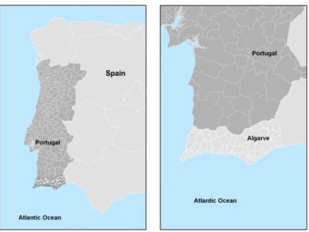
In an attempt to minimize the use of non-renewable resources, this dissertation offers a framework of different spatial instruments to understand the dynamics of regional change which are strongly linked to the importance of geographical space. Located in the southern region of Portugal, the Algarve is used as an experimental laboratory to test the concerns of environmental change. Several reasons justify this choice, especially related to a historic, socio-economic and environmental context.
(1) The Algarve is one of the most culturally diverse regions of Portugal. Occupied since the Phoenicians (Neville, 2007), it has offered since antiquity a unique cradle for civilizations, due to its outstanding coastal location to the rest of the World (Strabo, 2008);
3
Regional Change in the Algarve: A Geographical Information Systems Approach
(3) Nowadays, current policy issues and regional planning face a dilemma on coping with economic growth, while maintaining the quality of the environment without compromising the welfare.
1.2. Methodological Tools for GIS and Spatial Analysis
This dissertation uses Geographic Information Systems (GIS) and spatial analysis for interpretation, storage, data convergence and visualization of regional socio-economic and land use changes. Geographic Information Systems become key assets to build-up on the predictive power and creation of tools for interpretation of socio-economic data. These spatial variables are used as explanatory models to understand the parameters of (1) urban growth, (2) tourism propensity and (3) heritage risk. While urban growth models are developed based on transitions of land use, the propensity maps are calculated supported by existing datasets of spatial importance. Modelling of urban growth assumes the integration of complex system theory and takes advantage of the usage of Cellular Automata to deal with non-linearity of urban sprawl. The metrics of tourism propensity are levelled by spatial cluster analysis shedding some light on the patterns of Tourism choices and trends. Much of the heritage risk is followed by the articulation of the sections of urban growth and combined with predictive modelling approaches. Most of the analysis has been carried out in ArcGIS 9.x and Idrisi Andes.
4
Regional Change in the Algarve: A Geographical Information Systems Approach
methodologies and models that have been integrated in this dissertation. Furthermore, the acknowledgment that sustainable development may be better perceived by a complex system approach, calls for Geographic Information Sciences as a fundamental dimension of tools in the connection of spatial information with socio-economic and natural data. In this dissertation those datasets are integrated into different layers, allowing spatial non-linear manipulation and resulting into the different scenarios of environmental change. As pointed out by Nijkamp and Scholten (1993), GIS share a crucial role in linking land-use management with regional decision making. Combined with non-linear parameters of spatial scenarios, the decision making of the GIS tools lent the possibility of casting future visions for environmental and spatial planning. The combination of GIS, scenarios and modelling approaches, is translated in this dissertation into several different studies on complexity and environmental change in the Algarve. These studies provide an outlook concerning the future of decision making for the region, also sharing the current concern on consequences on land-use and human induced pressures due to economic growth.
1.3. Applied Methodology
5
Regional Change in the Algarve: A Geographical Information Systems Approach
coastal regions, and identifies Tourism as a main indicator for continuous urban pressure on the coastal area. While the paradigm of coastal urban growth has been studied previously by the European Union (EEA, 2006), the co-relation of urban growth with Tourism has been little analysed.
This leads to the second empirical study which assesses the direct relation of urban growth with Tourism. By filtering the spatial tourism attributes within their proximity to urban areas, Euclidean distances are weighted from urban centres and a relative weighting factor for Tourism in the Algarve becomes clear. Tourism is assessed as the main driver for economic prosperity in the Algarve, but also shown to be the main responsible negative externality as sink of sustainable regional development. The carried out spatial analysis, shows that it is important to find a different kind of approach for Tourism in the Algarve, which, although still an important driver for economic growth, should restrain from using the coastal area as main Tourism product. The application to sustainable tourism becomes a turning point of the spatial debate and spatial assessment, offering a solution of integrated tourism taking advantage of historical heritage as driver for economic development in the Algarve.
6
Regional Change in the Algarve: A Geographical Information Systems Approach
legislative process hinder the possibilities of better management of hinterlands and rural regions, translated in the continuous loss of the National Agricultural Reserve (Reserva Agrícola Nacional).
7
Regional Change in the Algarve: A Geographical Information Systems Approach
Table 1 – Expected resulting publications and published materials
Title Authors Journal / Book Publisher
A Multi-scenario prospection of urban change – the case of urban growth in the Algarve Vaz, Caetano, Nijkamp, Painho Landscape and Urban Planning Elsevier
Crossroads of Tourism – a complex spatial analysis of tourism and urban sprawl Vaz, Nainggolan, Nijkamp, Painho Journal of Sustainable Development Inderscience
Impacts on environmental law and regulation on agricultural land-use change
Vaz, Brito, Painho, Nijkamp
European Planning Studies
Taylor and Francis
Past Landscapes for the
Reconstruction of Roman Land Use: Eco-history Tourism in the Algarve
Vaz, Bernardes, Nijkamp Ecotourism: Management, Development and Impact NOVA Publishers
Urban heritage endangerment at the interface of future cities and past heritage
Vaz, Caetano, Cabral, Painho,
Nijkamp
The Annals of Regional Science
Springer
Historico-cultural sustainability and urban dynamics: A Geo-Information Science approach
Vaz, Nijkamp Enhancing the City: New Perspectives for
Tourism and Leisure
8
Regional Change in the Algarve: A Geographical Information Systems Approach
1.4. Assumptions
The dissertation proposes a symbiotic approach of theoretical and empirical analysis constructing a base for an integrative complex system approach. In this system, four assumptions are considered:
1. The systemic approach: Environment may be considered as a system, in which the different parts interact as a whole.
2. The dynamic approach: Scenarios and predictive modelling allow the analysis of temporal change.
3. Spatial representation: Spatio-temporal representation of reality is possible with spatial modelling where hypothesis are created that allow interpretation of environmental systems. Urban modelling and GIS are key-players for observation and spatial data analysis.
9
Regional Change in the Algarve: A Geographical Information Systems Approach
1.5. Objectives
One of the major concerns regarding sustainable development is land-use change, brought largely from urban growth, and asymmetric socio-economic strategies (Koomen et al, 2007). The socio-economic factors of land-use change, are often linked to policy-makers and should comply with more assertive strategies, as to create better decision support systems for sustainable development (Sanchez-Marre et al., 2008), resulting in better management, without compromising either economic activities or the preservation of biodiversity and heritage.
10
Regional Change in the Algarve: A Geographical Information Systems Approach
draws further on the non-linear toolsets. This is the case of Cellular Automata (CA) to assess the propensity for environmental change and as well as the state of predictive modelling based on endogenous and exogenous variables.
Figure 1 – Diagram of Part one
PART B of this dissertation uses the Algarve as a laboratory of analysis of the different
11
Regional Change in the Algarve: A Geographical Information Systems Approach
2) the dimensions of environmental law and regional impacts (Study 3). PART C offers a solution using heritage to regain the balance of existing regional asymmetries. Focusing on sustainable Tourism and critically evaluation Tourism as an opportunity for economic growth in the Algarve, an assessment of the historico-cultural potential of the region is assessed. The results of the main studies may lead to inquiries and interesting analysis which will allow scientific work to be carried out in the near future (some of the inquiries and analysis are reported on Figure 2)
12
Regional Change in the Algarve: A Geographical Information Systems Approach
.The existing archaeological landscape, offers a genuine attraction which rectifies the existing excess of economic activity along the coast fringe. While the Archaeological landscape is tested in Study 4, Study 5 shows the intricate relations endangering continuous urban growth on this unique landscape. Finally, Study 6 emphasises on the concept of regional sustainable development based on the existing historico-cultural sustainability, as a novel opportunity for coastal equilibrium in similar situations.
1.4. Hypothesis
The next figure (Figure 3) shows the intricate relationship of all the different Chapters and Parts. Furthermore, while the different parts summarize the organic structure of the dissertation, a series of Hypothesis are tested along the study. Thus, the diagram also responds to the different Hypothesis which is validated for each of the study within specific frameworks in an attempt of defining sustainable development and carrying capacity.
These Hypotheses are directly related to the development of the studies. Some of the Hypothesis arise from the relationship of one study-case to the other, as many of the questions may not be answered isolated, but rather, are a result of the interaction of different elements.
13
Regional Change in the Algarve: A Geographical Information Systems Approach
1) Multi-scenario and urban growth:
1. Hypothesis 1 Cellular Automata related to GIS allow accurate visualization of future landscapes within the region of the Algarve.
2. Hypothesis 2: Urban growth has a direct consequence on environmental ecological sustainability in the Algarve region.
2) Crossroads of Tourism:
1. Hypothesis 3: It is possible to relate spatial information with tourist attractors and land-use vulnerability.
2. Hypothesis 4: Tourism industry if not correctly managed may damage the fragile ecosystems.
3. Hypothesis 5: Land-use vulnerability within touristic attractors shed information of future urban growth and land-use change tendencies. 3) Urban Heritage Endangerment:
1. Hypothesis 6: Archaeological Predictive Models are important tools to measure cultural heritage for the Algarve.
2. Hypothesis 7: The historico-cultural landscape is successively becoming destroyed due to human impact on the environment.
4) Future works (Spatially articulated Social, Economic and Natural Model):
14
Regional Change in the Algarve: A Geographical Information Systems Approach
15
Regional Change in the Algarve: A Geographical Information Systems Approach
Chapter 2 –Economic, Social and Natural Factors in Regional Change
2.1. Complex Systems and Scenarios
The objective of this chapter is to understand the global dynamics that lead to environmental change from a spatial perspective. Three distinct and relevant dimensions have been considered in regional sustainable development: economic, social and ecological (van den Bergh, 1996; Haughton and Counsell, 2004). The intricate relation of those dimensions in space allows the application of spatial analysis to calculate the consequences of the carrying capacity on the physical environment. Human being has had a large impact on these different, systematically integrated dimensions, generating unpredictable spill-over effects.
The recent advances in systems theory facilitate the disaggregation of the complexity resulting from human transformation of the natural environment. In this process the spatio-environmental perspective is a key dimension of better understanding the complex relationship of environmental degradation driven by human behaviour.
The origin of complex system theory is strongly linked to the importance of coping with multiple aspects of intertwining realities of measurable and reliable data. System theory
16
Regional Change in the Algarve: A Geographical Information Systems Approach
possibility of a wider range of application within different domains of science (Meadows, 2008). Thus, complex systems as an attempt of understanding the consequences of a holistic approach to complexity of different parts within a system have been an interesting solution to generalize and formalize several aspects of change dynamics.
Complexity as such is better understood if cause-effect sequences among the elements of the system are defined, establishing more or less constant relationships among them able to be extended in time. These dynamic aspects of complex systems are of great importance to foresee the possible structural change and create probable outcomes which are named scenarios. Scenarios are strongly stimulated by the possibility of
understanding the consequences within systems to assess future change in ‗what if‘
relationships established between different agents. The convergence of the formal knowledge of complex system theory, related to scenario modelling, allows generating non-linear outcomes of future events which may combine the economic, social and natural dimensions of environmental change (Allen, 2001).
17
Regional Change in the Algarve: A Geographical Information Systems Approach
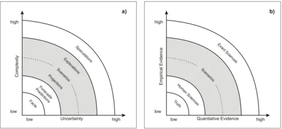
the politics involving the sustainability process. As those questions scope a more specific aspect of sustainable development, these qualitative assessments do not consider alternative possibilities for future outcomes of different political choices. Therefore, although sustainability indicators may provide important information, they do not provide a toolbox with direct application. However, such results may be achieved by a combination of qualitative assessment of environmental indicators. Combining relevant environmental information may help to explore future outcomes based on socio-economic tendencies. These consequences are of social importance (Dunlap and Catton, 1979) and permit an interdisciplinary research approach (Dickens, 2001) in which the environment has a clear role in the construction of future scenarios.
18
Regional Change in the Algarve: A Geographical Information Systems Approach
more robust explanations to certain phenomena which exist within social and behavioural sciences.
Figure 4 - Central role of scenarios (Alcamo and Heinrichs, 2009) and (b) paradigm shift of human and exact sciences
19
Regional Change in the Algarve: A Geographical Information Systems Approach
2.2. Economics and Environmental Change
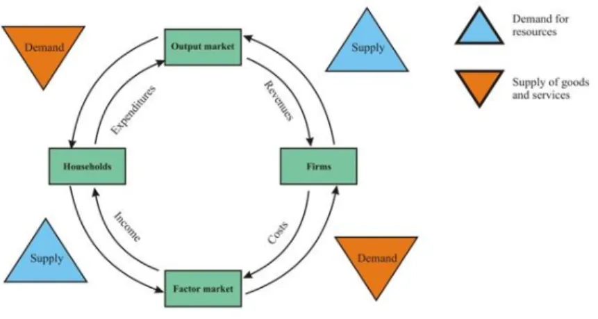
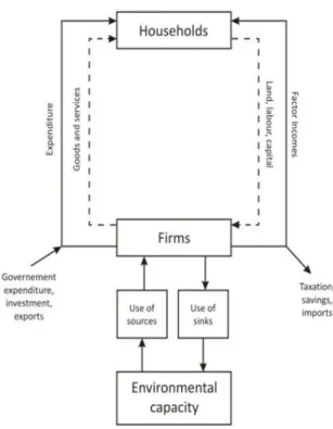
The relationship between resources and commodities is inherently quantitative in nature and its analysis allows a structured understanding of a system. Human kind depends on natural environment to anticipate demand created for (Hussen, 2004): (a) the extraction
of non-renewable resources (such as iron ore, fossil fuels, etc.) and the harvest of
renewable resources (such as fish of various species, agricultural products, forest
products, etc.) to be used as factors of production; (b) the disposal and assimilation of
wastes; (c) the consumption of environmental amenities (such as bird watching,
canoeing, hiking national park trails, observing a morning sunrise or an evening sunset,
etc.). From an economic perspective, those variables may easily be integrated in a
circular flow model (Figure 5), constructing a restrictive relation with the environment.
Figure 5– Circular flow model (adapted from Daly and Farley, 2004)
20
Regional Change in the Algarve: A Geographical Information Systems Approach
increasing demand from several sectors and not having often the capacity to develop the resources necessary. This consequence of development has lead over the coming years to a collapse of natural and environmental landscapes as well as societal rivalries which become a consequence of uncertain production choices and production regions.
O‘Neill and Kahn (2000), explain how economic development is dependant of ecological
21
Regional Change in the Algarve: A Geographical Information Systems Approach
In fact, the balance needed for environmental sustainability is a direct consequence of ecological and economic efficiency. Nevertheless, the existence of non-renewable resources marked by the carrying capacity of the environment which is directly related to a growing demand of production due to population growth jeopardizes sustainability and queries therefore limits to growth (Meadows et al., 2004). Mainly, this problem is intrinsically related to the amount of pollutants thrown into the ecosystem which is naturally associated to a strong economic growth and a tendency of spatial aggregation, and over time, this paradigm of population growth and pollutants has grown into an issue addressing the technological aspect of coping with by-products of population increase and demand.
22
Regional Change in the Algarve: A Geographical Information Systems Approach
Figure 6– Environmental Kuznets Curve
As seen, economic analysis connected to spatial information, may allow the understanding of more causal relationships which fragment the complexity of the environmental-economical relation and may synthesise accurately the more complex
relation of environmental economics which ―(…)undertakes theoretical or empirical
studies of the economic effects of national or local environmental policies around the
world, including effects on pollution, research and development, physical investment,
labour supply, economic efficiency, and the distribution of real income. Particular issues
include the costs and benefits of alternative environmental policies to deal with air
pollution, water quality, toxic substances, solid waste, and global warming.‖ (National
Bureau of Economic Research).
23
Regional Change in the Algarve: A Geographical Information Systems Approach
wellbeing is the decisive goal. This concept brings forth the mentioned EKC, as direct reflection is a result of evolution of income. In a neoclassical concept, environmental degradation therefore, only becomes relevant when directly affecting human welfare. Environment, by those means, is faced as a quantified product and sustainability is necessarily a reflex on environmental consequences which resources may be enhanced and therefore provides a better capitalization of its initial resources.
Neoclassical economists recognize the structural importance of empirical research (Illge and Schwarze, 2009) brought by the strong background based on processes of evaluation and testing, which allow quantitative conclusions. And, in this sense, environmental economics from a neoclassical perspective becomes more macroeconomic, justifying the
demand flows at a definite scale for choices made upon the environment and creation of economic welfare. On the other hand ecological economy is centred not necessarily on the welfare of man, but rather, on the welfare of an ecological metabolism that attributes value to nature itself, not as a resource. In this context, both differ deeply: Contrary to neoclassical reasoning that forfeits environment as an externality (positive if the benefits surpass the cost of maintenance, negative in the other case), ecological economy considers man as the externality to the environment.
24
Regional Change in the Algarve: A Geographical Information Systems Approach
the Gross Domestic Product (GDP) and existence of employment, which may reflect on which areas may become urbanized.
Leontief‘s input-output model ―describes and explains the level of output of each sector
of a given national economy in terms of its relationships to the corresponding levels of
activities in all the other sectors. (…)‖ while ―(…) [permitting] to explain the spatial distribution of output and consumption of various goods and services and of their growth or decline—as the case may be—over time.‖ (Leontief, 1986, p.241). Traditional
economic models, as the input-output model, may adapt themselves at the regional scale. The consequence is a plausible regional scope of analysis, which addresses spatial uncertainty of economic aggregates. Regional and urban economics, explore largely the spatial dimensions entailing the possibilities of predicting outcomes given indexed values of economic throughput, scarcity of resources and sectors of economic activity. In this
sense, regional economics may be defined as the ―Regional Economics analyses the
spatial dispersion and coherence of economic activities.‖ (Nijkamp and Mills, 1987).
Supported by, ―Conceiving space as a grid system has the advantage of explicitly
presenting a map of spatial activities to any desired level of detail (…)‖ where ―Similarly,
economic regions may be constructed according to socio-cultural or historical criteria or
by using such economic variables as industrial structure, rates of unemployment, and per
capita income. Or, economic regions may be delineated according to the intensity of
economic exchange via commodity exchange and factor mobility. Administrative or
25
Regional Change in the Algarve: A Geographical Information Systems Approach
according to historical or political phenomena.‖ (Siebert, 1993). This representation of
detailed space, allows a better perception of the dimension of local economic, social and natural change, leading to a better decision making and analysis of local/regional trends, manifesting the importance of human behaviour in an environmental context (Isard, 1956).
2.3. Society and Environmental Change
Society has changed drastically over the last 200 years. From a chronologic perspective, the anthropocentric role of social factors has been questioned increasingly by a broad number of scholars justifying a new social paradigm related to a society with less structured values, characterized by a lack of clear concepts and ideals. Society today is living according to scholars in a postmodernist era that gained expression over the sixties in western societies. A key trait of postmodernism from a social perspective, is the questioning of values established since the enlightenment and modernism, and contrary to modernism ideologies, defies current values on a constructive, often anthropocentric rationale leading towards a strong criticism of pre-established values.
Extending the postmodernist criticism not only in the domain of the arts and on iconic symbolism of cultural background in modern societies, postmodernism sets nowadays new standards for a critic of an inconsequent and sometimes obsolete capitalistic model. Example of this is the trend of following a paradigm shift, from a society established in the idea where the key concept should be limitless production, driven by limitless consumption to a level of a future shock (Toffler, 1970) where technological
26
Regional Change in the Algarve: A Geographical Information Systems Approach
In fact, the Enlightenment allowed establishing an ideological shift of a man centred role in the universe and the Modernism further extended the anthropocentric role to a scientific conglomeration of human and exact sciences. Today‘s Postmodernism defies
the boundaries of science, articulating new transversal areas of study in which human and technology integrate to fit elegantly in framework of new scientific directions.
Geographic Information Systems (GIS) may be considered one of such recent scientific areas of study. Reaching an important role for analysis of spatial related phenomena, recent years have shown an on-going increase of GIS as tools for social sensitizing and knowledge diffusion. Spatial information, as such, seems to replace the traditional information system by associating the spatial perception to analyse different kinds of visual information and aiding in the forecast of human and natural trends.
Recent applications of software such as Google Earth™ and Microsoft Virtual Earth™
that, offer a spatial visualization of geographic environmental and topographic characteristics of cultural, social and ecological phenomena, enhancing the way we perceive reality. The impact of generalized and long term use of such visualized information at a social level may have important results on the diffusion of existing environmental change awareness.
27
Regional Change in the Algarve: A Geographical Information Systems Approach
phenomena such as web 2.0 have led to a more social role of information transition.
Modelling of future land use scenarios at a regional context is thus, an important evolution for the possibilities of analysing future change and social awareness of environmental fragility.
Over 45 years ago, Roger Tomlinson conceived the first Geographic Information System (GIS) as a tool for land use planning for the Canada land inventory (Thill, 2000). It would not be expected, that a few decades later GIS would transcend in so many aspects the traditional knowledge of regular mapping tools. Meanwhile, GIS have become complex systems of interconnected parts constituted by information products, software, data, hardware, procedures and people (Tomlinson, 2003). It is surprising that this vision would have 40 years earlier, the same notion of complexity and arguments of the intricate parts that form the complexity of a GIS. Thus - although the vision has not changed in time - perspective on technological evolution did, and as a consequence issues that GIS
couldn‘t handle forty years ago due to technological limitations, are now solvable. Thus,
28
Regional Change in the Algarve: A Geographical Information Systems Approach
Information Science). Attending elementary properties related to GIS related technologies (Goodchild, 1990) GIS permits the creation of a new discipline, with considerable depth, focusing on the richness of the challenges brought by scholars (Mark, 2003).
As a result from these different dimensions, Geographic Information Science (GISc) is an expanding discipline of study, the National Centre for Geographic Information and Analysis (NCGIA) defined quite early five key topics of research in its field of study in 1987: (1) Spatial analysis and spatial statistics, (2) Languages of spatial relations, (3) Visualization, (4) Artificial intelligence and expert systems (5) Social and institutional issues.
These different scopes of interest represent a reflection of the importance of the different fields of study directly proposed by GISc, but the fifth topic underlies the need and the importance of Social awareness.
29
Regional Change in the Algarve: A Geographical Information Systems Approach
information with metadata to reproduce ecological, geographical, natural and cultural phenomena.
Within a framework of spatial science, relevant investigation has been applied to understand economic, social and natural change:
1) In a European context, where existent asymmetries among an expanding Europe. Such circumstances seem to indicate the need for a generic scope definition confined by divergent policy choices and environmental decisions.
2) Also, the legislation for land use change for instance, is a reflex of economic activity and consequence of regional production as well as market outputs in a context of growth. Affecting employment, migration patterns and life quality, the understanding of land-use patterns in a context of temporal land change, creates the needs of planning issues at national, regional and local scales.
30
Regional Change in the Algarve: A Geographical Information Systems Approach
The symbiotic nature of land-use and environmental sustainability has had a rising
interest since the publication of works such as Rachel Carson‘s ―Silent Spring‖ 1 (Carson,
1962), in which the criticism of man-made technologies (pesticides) showed an increasing baleful effect on environment. The awareness of the role of man as a driving
force upon the environment became further obvious in ―The Limits to Growth‖
(Meadows and Meadows, 1972) where from a pragmatic perspective, understanding of the consequences of population growth showed the dreadful results of an ever increasing world population given the scarcity of available resources. Nevertheless, mentioned both volumes had a certain number scepticism attached, often related to the uncertain nature of quantitatively consequences of prediction as well as relation to human welfare in general. In fact, environmental issues brought to general public from the very beginning of its origins, despite best intentions, had always had a certain burden of scientific community which tended to argue on the media as a shallow understanding of real quantifiable scientific methodologies. Both books became outstanding bestsellers and have decades later inspired many views on social sciences and on individual behaviour. Also, the scientific community brought a larger recognition of the importance of social cogitation on the disastrous consequences on environment. Forty years later, the role of society regarding environmental change remains unclear while vastly assimilated as a key player by the media. As policies become a consequence in developed countries of democratic legislation, the vox populi may have an important role in coping with sustainable
development and environmental change. Recent articles such as in the National Geographic of March 2009, ―Saving Energy starts at Home‖ (Miller, 2009), concluding
1
31
Regional Change in the Algarve: A Geographical Information Systems Approach
with the final remark of ―what do we have to lose‖, clearly shows the possibility of a
social, although still unrefined, role of generic society and mass media to intertwine social environmental awareness.
32
Regional Change in the Algarve: A Geographical Information Systems Approach
33
Regional Change in the Algarve: A Geographical Information Systems Approach
Chapter 3 – Material and Methods: GIS and Spatial Analysis to Evaluate Environmental Impact Assessments in the Algarve
The region of the Algarve comprises a total area of 4899 km2 which is 5,5% of continental Portugal (Pena and Cabral, 1997) and is the farthest region to the south of Portugal. Bathed by the Atlantic Ocean to the south and west to the north, a massive mountain range, the Serra do Caldeirão, separates the Algarve from the Alentejo. This
encapsulated morphology of the region, has had influence on a more temperate microclimate than the rest of Portugal, as well as some vegetation and wildlife particularities which make this area a unique habitat for many different species. From a geomorphologic perspective, the Algarve shows three distinct layers of singular cultural, vegetative and ecological aspects.
The location of the Serra do Caldeirão is circumscribed by a mountain range, and is known as the Barrocal, while the region to the south of the Barrocal is the Interior and
34
Regional Change in the Algarve: A Geographical Information Systems Approach
Understanding the dynamics of spatio-temporal change has been a persistent effort for regional and urban planning purposes. Evaluation of socioeconomic effects on the environment has been combined with the consequences of land-use change to propose better strategic tools to cope with change processes.
A relevant initiative in the Algarve has been the implementation of the PROT Algarve (Plano Regional de Ordenamento do Território do Algarve transl. Regional Plan for
Territorial Management in the Algarve). The PROT Algarve converges within the Municipal Directory Plans part of the framework of the National Policy and Territorial Management Program (Programa Nacional da Política de Ordenamento do Território -
PNPOT). PNPOT sets a series of guide rules for sustainable development of the Portuguese territory which may be summarized as (PROT Algarve, 2008):
a) Preserve and valorise biodiversity, landscape as well as natural and cultural heritage,
as well as sustainable usage of geology and energy resources while hindering and
minimizing damage.
b) Reinforce national territorial competitiveness within the Iberian, European, Atlantic
and global context.
c) Promote the polycentric development of territories as well as reinforce infrastructures
supporting integration and territorial cohesion.
d) Assure territorial equity by providing infrastructures and collective equipment while
35
Regional Change in the Algarve: A Geographical Information Systems Approach
e) Expand information and communication channels as to provide a crescent usage of
such services citizens, institutions and stakeholders.
f) Reinforce the quality and efficiency of territorial management by encouraging the
informed participation of citizens and institutions.
Supporting the territorial dimension is therefore a key aspect which leads to a more competitive region, sharing impacts at social, economic and natural level. It is the combination of those key aspects that allow the equitable assessment of spatial sustainable development, within a policy framework for Portugal. PROT Algarve (2008) advances with a territorial analysis of these factors for the Algarve. One of the key aspects of the territorial dimension of sustainability, are the physical consequences of land-use change, largely visible over the last decades in the Algarve. Urban growth, has been one of the key characteristics of the region. Under the European umbrella, several spatial data infrastructures and Programmes have been created to evaluate land-use change and urban growth. The INSPIRE initiative, attempts to create a joined effort of
―fully compatible and integrated databases without restrictions on reuse of data,
facilitating access to geographic information assets held by a wide range of stakeholders.
Widespread implementation of SDIs will bring substantial economic, social and
environmental benefits‖ (Masser, 2007). Several urban growth models have addressed the
36
Regional Change in the Algarve: A Geographical Information Systems Approach
37
Regional Change in the Algarve: A Geographical Information Systems Approach
Figure 7 - Methodology
38
Regional Change in the Algarve: A Geographical Information Systems Approach
Social information on population density, as well as the existence of touristic infrastructures and knowledge of their spatial location, shall approach the relationship of urban propensity within touristic areas, answering the question whether tourism is a driver of urban growth for the Algarve. The answer to this question poses the agenda of resilience for regional decision making, and allows retrieving further crucial information for carrying capacity in the region. This information is also spatially explicit, and will convey into a tourism propensity map which measures with a reliable degree of accuracy due to a jack-knife sampling technique, the relation of tourism infrastructures and urbanity.
Combination of agglomerated propensity data – from the urban propensity map and tourism propensity map alike – will be combined with the conditions driven by the third driver which undertakes the question of heritage protection, defined as a key factor for sustainable development. Those are discussed in the papers in the subsequent chapter, and may be understood as the relationship of urban growth to physical land use change, tourism attractors and cluster analysis of propensity for unsustainable areas and predictive modelling of historico-cultural heritage for sustainable choices. This shall allow an interaction of reciprocal influences among different agents (Legrand, 1991).
39
Regional Change in the Algarve: A Geographical Information Systems Approach
dynamic and its motion. Hence, Cellular Automata (CA) are the logical step to combine dynamic models with intuitive agents that relying on a set of variables allow prediction of certain types of behaviours. These types of models have their branches in the areas of computational sciences and find a vast use in many different areas. As they are capable of reflecting quite clearly the behaviour of groups and biological variables, they have extensively been used in the social sciences after all in this circumstances “computers
offer a solution to the problem of incorporating heterogeneous actors and environments,
and nonlinear relationships (or effects).” (Lansing, 2002). Cellular Automata are thus, discrete mathematical models that consist of a grid of cells that allow interaction of variables along the designated system, involving the variable time, representing as a consequence a dynamic system in which patterns of behaviour may be observed. Due to their intrinsic nature (grid based system with specific number of cells) they are quite adaptable to a Geographical Information System (GIS) environment, given the necessary software and programming experience or attachable models, one can adapt CA easily to the context of a GIS and do predictive multi-temporal dynamics of change on a spatial basis.
To allow the interaction of a Cellular Automata, a few logical presuppositions are necessary. Those presuppositions are basically the programmers or the user‘s premises which define the behaviour of the Cellular Automata. In a GIS context, the set of premises that define specific rules may very well be the following:
40
Regional Change in the Algarve: A Geographical Information Systems Approach
- Distance Factors: Existing distance between CA and Objects (Tobler‘s Law)
It is in the interaction between external, internal and distance factors that the CA defines a set of logic rules (e.g. should slope be higher than x, urban construction is not feasible) and complexity of those rules that lies the capacities of predictive powers of the CA. In other words, though more rules define logical behaviours of the automata and though more data is made available, the better the CA is calibrated to reach accuracy in its predicted power.
The spatial relation between cellular automata, rules and interaction is defined in a common system of matrix value: That is for instance, a given spatial location is converted into a grid in which each cell represent a specific aggregate with a common size and unique weight. The result is a so-called raster, which mathematically can be understood as a raster. Having understood this, we may consider that a CA is a cell within the spatial grid which interacts among the values we have defined (in our set of established rules) optimal for action. Thus, a CA generates random behaviours based on the set of rules and number of iterations allowing the observer to assess a predicted model. The necessity to calibrate the model to understand the accuracy of spatial models using CA is an inherent feature: The automaton is calibrated based on a known moment and alternative rules are defined on a surface (e.g. suitability map) to assemble the dynamics of its interactions.
41
Regional Change in the Algarve: A Geographical Information Systems Approach
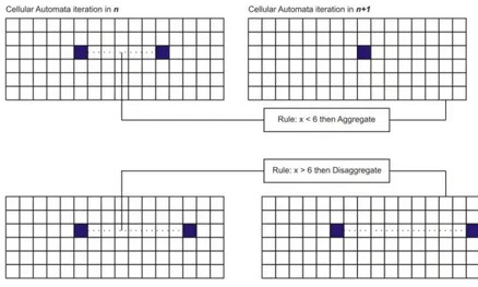
complex then shown. A simple Cellular Automata is behaving in function of its proximity. The rule defined is trivial: Should distance between the blue cells be less than 6 (that is, should less than 6 cells separate from the two blue cells), the cells transform aggregate into a single cell. On the other hand, should distance be greater than 6 cells, cells disperse from each other. This fundamental relation shows some contiguity in
Tobler‘s law of distance and proximity which for spatial analysis is of extreme
importance and is recurrently used in cellular automata.
Figure 8 - Example of CA rules and projection in n+1
42
Regional Change in the Algarve: A Geographical Information Systems Approach
sets of rules that may be clearly assessed and help us shed some light on future spatial behaviours.
Though true this may be, we have to understand the following clearly: A system, as linear complex as it is, is not accurate due to its intrinsic nature. Unpredictability therefore is a constant that complicates the fusion of future cognition in predictive modelling
approaches. This limitation is avoided elegantly by assuming that the model has a probabilistic contiguity of occurrence. Probability of occurrences assumes therefore a given error margin, and as a result, forecasting of future scenarios is support options of within an expert panel, or such as of Multi-Criteria Evaluation or even using different hypothesis.
43
Regional Change in the Algarve: A Geographical Information Systems Approach
becomes spatially relevant, allowing the composition of such information to composite indexes through computational procedures (Salvatti and Zitti, 2008).
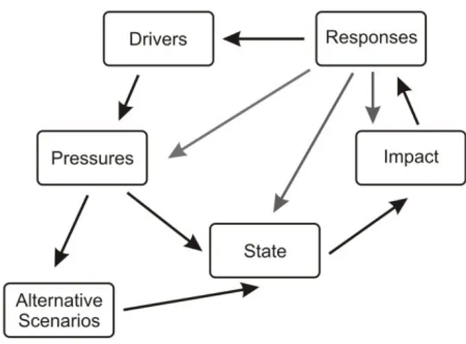
From Omann et al. (2009) the following definitions are considered:
1. Driving forces are changes in the social, economic and institutional systems (and/or their relationships) which are triggering, directly and indirectly, Pressures on biodiversity. Pressures are consequences of human activities (i.e. release of chemicals, physical and biological agents, climate change, extraction and use of resources, patterns of land use, and creation of invasion corridors) which have the potential to cause or contribute to adverse effects (impacts).
2. The state of biodiversity is the quantity of biological features (measured within species, between species and between ecosystems), of physical and chemical features of ecosystems, and/or of environmental functions, vulnerable to (a) pressure(s), in a certain area.
3. Impacts are changes in the environmental functions, affecting (negatively) the social, economic and environmental dimensions, and which are caused by changes in the State of the biodiversity.
44
Regional Change in the Algarve: A Geographical Information Systems Approach
A causal pathway is established based on the previous definitions for Land degradation (pressure) and alternative scenarios (Figure 9). Originating from driving forces the impacts given alternative scenarios regarding socio-economic calibration of indicators is demonstrated.
Figure 9 - Simplified DPSIR framework with alternative scenarios
45
Regional Change in the Algarve: A Geographical Information Systems Approach
Chapter 4 - A Multi-Scenario Forecast of Urban Change: A Study on Urban Growth in the Algarve
4. 1 Abstract
46
Regional Change in the Algarve: A Geographical Information Systems Approach
The spatial analysis does not only employ conventional quantitative methodologies, but also covers important qualitative evaluation processes by the assembly of story-lines which articulate traditional scenario approaches. However, the design of story-lines is intrinsically subjective and qualitative, and has to deal with the problem of accuracy in quantifying the results. This new methodology utilizes both quantitative and qualitative spatial results by a comparative validation of built scenarios, in order to highlight future land use trends. In particular, three scenarios will be explored, each with specific socio-economic paths: the first scenario envisages a maximization of urban growth in the area, brought by a prosperous economy and the continuing development of mass tourism. The second scenario is based on the actual indicators of the region in terms of socio-economic activity while, the third scenario shows a tendency of rising rural activity and addresses the disparities between rural areas and the fringe of the coastal regions.
47
Regional Change in the Algarve: A Geographical Information Systems Approach
4. 2. Introduction
Europe has experienced unprecedented urban change and population increase over the last 30 years and this is expected to continue (Cohen, 2004). In 2008, the population of the European Union (EU) rose by 2.1 million, resulting in the growth of GDP by 0.4 per
cent. Europe‘s multi-cultural and liberal policies have directly contributed to the
expansion of the EU, making it today the strongest world economy (Moravcsik, 1993). However, the downside of this population increase is reflected in the rapid land-use cover change (Bilsborrow and Ogendo, 1992), especially within the metropolitan areas of larger cities in the EU, or other important socio-economic areas (EEA, 2006a).