HESSD
12, 6683–6753, 2015The Hydrological Open Air Laboratory
(HOAL) in Petzenkirchen
G. Blöschl et al.
Title Page
Abstract Introduction
Conclusions References
Tables Figures
◭ ◮
◭ ◮
Back Close
Full Screen / Esc
Printer-friendly Version
Interactive Discussion
Discussion
P
a
per
|
Discussion
P
a
per
|
Discussion
P
a
per
|
Discussion
P
a
per
|
Hydrol. Earth Syst. Sci. Discuss., 12, 6683–6753, 2015 www.hydrol-earth-syst-sci-discuss.net/12/6683/2015/ doi:10.5194/hessd-12-6683-2015
© Author(s) 2015. CC Attribution 3.0 License.
This discussion paper is/has been under review for the journal Hydrology and Earth System Sciences (HESS). Please refer to the corresponding final paper in HESS if available.
The Hydrological Open Air Laboratory
(HOAL) in Petzenkirchen: a hypotheses
driven observatory
G. Blöschl1,2, A. P. Blaschke1,2,8, M. Broer1, C. Bucher1,3, G. Carr1, X. Chen1, A. Eder1,4, M. Exner-Kittridge1,5, A. Farnleitner1,6,8, A. Flores-Orozco7, P. Haas1,2, P. Hogan1, A. Kazemi Amiri1, M. Oismüller1, J. Parajka1,2, R. Silasari1,
P. Stadler1,5, P. Strauß4, M. Vreugdenhil1, W. Wagner1,7, and M. Zessner1,5
1
Centre for Water Resource Systems, TU Wien, Karlsplatz 13, 1040 Vienna, Austria
2
Institute of Hydraulic Engineering and Water Resources Management, TU Wien, Karlsplatz 13/222, 1040 Vienna, Austria
3
Institute of Building Construction and Technology, TU Wien, Karlsplatz 13/206, 1040 Vienna, Austria
4
Institute for Land and Water Management Research, Federal Agency for Water Management, Pollnbergstraße 1, 3252 Petzenkirchen, Austria
5
Institute for Water Quality, Resource and Waste Management, TU Wien, Karlsplatz 13/226, 1040 Vienna, Austria
6
HESSD
12, 6683–6753, 2015The Hydrological Open Air Laboratory
(HOAL) in Petzenkirchen
G. Blöschl et al.
Title Page
Abstract Introduction
Conclusions References
Tables Figures
◭ ◮
◭ ◮
Back Close
Full Screen / Esc
Printer-friendly Version
Interactive Discussion
Discussion
P
a
per
|
Discussion
P
a
per
|
Discussion
P
a
per
|
Discussion
P
a
per
|
7
Department for Geodesy and Geoinformation, TU Wien, Gußhausstraße 25–29/120, 1040 Vienna, Austria
8
Interuniversity Cooperation Centre for Water & Health, TU Wien, Vienna, Austria
Received: 26 June 2015 – Accepted: 26 June 2015 – Published: 14 July 2015
Correspondence to: G. Blöschl ([email protected])
HESSD
12, 6683–6753, 2015The Hydrological Open Air Laboratory
(HOAL) in Petzenkirchen
G. Blöschl et al.
Title Page
Abstract Introduction
Conclusions References
Tables Figures
◭ ◮
◭ ◮
Back Close
Full Screen / Esc
Printer-friendly Version
Interactive Discussion
Discussion
P
a
per
|
Discussion
P
a
per
|
Discussion
P
a
per
|
Discussion
P
a
per
|
Abstract
Hydrological observatories bear a lot of resemblance to the more traditional research catchment concept but tend to differ in providing more long term facilities that transcend the lifetime of individual projects, are more strongly geared towards performing inter-disciplinary research, and are often designed as networks to assist in performing
col-5
laborative science. This paper illustrates how the experimental and monitoring setup of an observatory, the 66 ha Hydrological Open Air Laboratory (HOAL) in Petzenkirchen, Lower Austria, has been established in a way that allows meaningful hypothesis test-ing. The overarching science questions guided site selection, identifying dissertation topics and the base monitoring. The specific hypotheses guided the dedicated
moni-10
toring and sampling, individual experiments, and repeated experiments with controlled boundary conditions. The purpose of the HOAL is to advance the understanding of wa-ter related flow and transport processes involving sediments, nutrients and microbes in small catchments. The HOAL catchment is ideally suited for this purpose, because it features a range of different runoffgeneration processes (surface runoff, springs, tile
15
drains, wetlands), the nutrient inputs are known, and it is convenient from a logistic point of view as all instruments can be connected to the power grid and a high speed glassfibre Local Area Network. The multitude of runoffgeneration mechanisms in the catchment provide a genuine laboratory where hypotheses of flow and transport can be tested, either by controlled experiments or by contrasting sub-regions of different
20
characteristics. This diversity also ensures that the HOAL is representative of a range of catchments around the world and the specific process findings from the HOAL are applicable to a variety of agricultural catchment settings. The HOAL is operated jointly by the Vienna University of Technology and the Federal Agency for Water Management and takes advantage of the Vienna Doctoral Programme on Water Resource Systems
25
HESSD
12, 6683–6753, 2015The Hydrological Open Air Laboratory
(HOAL) in Petzenkirchen
G. Blöschl et al.
Title Page
Abstract Introduction
Conclusions References
Tables Figures
◭ ◮
◭ ◮
Back Close
Full Screen / Esc
Printer-friendly Version
Interactive Discussion
Discussion
P
a
per
|
Discussion
P
a
per
|
Discussion
P
a
per
|
Discussion
P
a
per
|
of the hypothesis testing and summarises the lessons learned. The paper concludes with an outlook on future developments.
1 Introduction
Understanding water related flow and transport processes in catchments and their in-teractions with other environmental processes across space and time scales are
es-5
sential research issues in the context of environmental technology, planning and man-agement. From a water quantity perspective, understanding runoff generation mech-anisms is very important for better estimating floods that may occur in small catch-ments, in particular if one is interested in extrapolating from small to large floods (Merz and Blöschl, 2008). Water yield under different management options as well
10
as land–atmosphere feedbacks are particularly relevant when addressing issues of climate change. From chemical and sediment perspectives, understanding the rele-vant mechanisms is important in the context of land management practices that aim at reducing sediment production (e.g. Yeshaneh et al., 2015), and for water resources management where the interest resides in understanding the fate of nutrients and
de-15
signing relevant management practices (Schilling et al., 2005; Zessner et al., 2005; Strauß and Klaghofer, 2006; Kovacs et al., 2012). From a human health related per-spective, characterising microbial faecal hazards in water and identifying contamination sources contribute to more reliable hazard characterisation and risk estimation in the context of water safety management, for example by allowing target-oriented protection
20
measures in the catchment and delineating effective and site specific protection zones (Reischer et al., 2011; Farnleiter et al., 2011). While these research issues are relevant in their own right, they are also closely connected to each other through process inter-actions. Integrated research into these processes is therefore needed to shed light on the interactions and fully explore the causal relationships of the catchment system.
25
HESSD
12, 6683–6753, 2015The Hydrological Open Air Laboratory
(HOAL) in Petzenkirchen
G. Blöschl et al.
Title Page
Abstract Introduction
Conclusions References
Tables Figures
◭ ◮
◭ ◮
Back Close
Full Screen / Esc
Printer-friendly Version
Interactive Discussion
Discussion
P
a
per
|
Discussion
P
a
per
|
Discussion
P
a
per
|
Discussion
P
a
per
|
the landscape are strongly controlled by the forcing of the weather. It is therefore diffi -cult, if not impossible, to conduct controlled experiments where one varies the bound-ary conditions in a prescribed way. As a consequence, the processes associated with water flow are intrinsically non-repeatable and require particular care when hypothe-sis testing (Blöschl et al., 2014). Second, the processes occur at the catchment scale
5
(where much of the interesting process interactions occur) and may not be present at the small laboratory scale. As a result, the experimental setup must be designed at the catchment scale which, again, involves a number of scientific and logistic challenges.
Experimental catchments have a long tradition in hydrology. Some corner stones in-clude the Coweeta hydrologic laboratory (Southern Appalachians) in the early 1930s
10
where the focus was on forest management practices (Swank and Crossley, 1988; Elliott and Vose, 2011), the Plynlimon catchment (Wales) in the late 1960s where pol-lution was the main interest (Kirby et al., 1991; Robinson et al., 2013), the Weiherbach (Germany) and Löhnersbach (Austria) catchments in the 1990s where a broader, inter-disciplinary approach was taken (Plate and Zehe, 2008; Zehe et al., 2011; Kirnbauer
15
et al., 2005); and the Tarrawarra catchment (Australia) in the 1990s where the focus was specifically on spatial process patterns (Western et al., 1998, 1999; 2001). An overview of some of the European experimental catchments is given in Schumann et al. (2010) and Holko et al. (2015).
More recently, the concept ofenvironmental observatorieshas been developed and
20
implemented. Examples are the Critical Zone Observatories (CZO) in the US where the starting point was geochemical processes (e.g. Anderson et al., 2008; Lin and Hopmans, 2011), and the Terrestrial Environmental Observatories (TERENO) in Ger-many where the starting point was processes at the hydrological–ecological interface (Zacharias et al., 2011). While these observatories bear a lot of resemblance to the
25
re-HESSD
12, 6683–6753, 2015The Hydrological Open Air Laboratory
(HOAL) in Petzenkirchen
G. Blöschl et al.
Title Page
Abstract Introduction
Conclusions References
Tables Figures
◭ ◮
◭ ◮
Back Close
Full Screen / Esc
Printer-friendly Version
Interactive Discussion
Discussion
P
a
per
|
Discussion
P
a
per
|
Discussion
P
a
per
|
Discussion
P
a
per
|
search. (c) Often they are designed as networks to assist in performing collaborative science within the research community. Indeed, long-term, interdisciplinary research in networks may be the hallmark of catchment-scale experimental research in an era where “Humans may no longer be treated as boundary conditions but should be seen as an integral part of the coupled human-nature system . . . [and] the coupling between
5
the geoscience disciplines . . . gets more important.” (Blöschl et al., 2015, p. 17). Establishment of research catchments or hydrological observatories may be either driven by management questions as was the case with much of the early experimen-tal work, or by fundamenexperimen-tal research questions, and the two aims may feed into each other. In both instances, the experimental or monitoring setup must be designed in
10
a way that enables the critical research questions to be tested. The classical example are paired catchment studies (e.g. Brown et al., 2005) where the effects of forest man-agement on the hydrological cycle are studied with a similar, untreated catchment used as a control. Differences in the observations between these two catchments are then used to test hypotheses on, e.g. the effects of forest on water yield. Again, a classical
15
hypothesis to be tested by this setup is that forest cutting will increase water yield from the catchment. In the Coweeta, for example, “the largest water yield increases occurred the first year after cutting when evapotranspiration (Et) was most reduced due to mini-mal leaf area index (LAI). As vegetation regrew, LAI and Et increased and streamflow declined logarithmically, until it returned to the pre-treatment level by five to six years.”
20
(Elliott and Vose, 2011; p. 906). For more complex hypotheses, the experimental or monitoring setup must be more elaborate in order to allow the hypothesis testing in a meaningful way.
The purpose of this paper is to illustrate how the experimental or monitoring setup of an observatory can be established in a way that allows meaningful hypothesis
test-25
HESSD
12, 6683–6753, 2015The Hydrological Open Air Laboratory
(HOAL) in Petzenkirchen
G. Blöschl et al.
Title Page
Abstract Introduction
Conclusions References
Tables Figures
◭ ◮
◭ ◮
Back Close
Full Screen / Esc
Printer-friendly Version
Interactive Discussion
Discussion
P
a
per
|
Discussion
P
a
per
|
Discussion
P
a
per
|
Discussion
P
a
per
|
2 Science strategy of the HOAL
The success of a research programme hinges on whether new, cutting-edge scien-tific findings are achieved. The HOAL observatory is designed to facilitate cutting-edge research by providing long-term experimental infrastructure, fostering interdisciplinary collaboration and encouraging networking within the science community. All three
as-5
pects are considered through the prism of the hypotheses to be addressed.
2.1 Long-term experimental infrastructure
Some of the most interesting science questions require long term observation. These include questions related to hydrological change where one aims at detecting diff er-ences of hydrological fluxes and/or processes between decades. Another such
ques-10
tion relates to hydrological extremes, since the likelihood of observing extreme events increases with the observation period. At the same time, long term infrastructure can most efficiently be used if a range of complementary research questions are addressed that all build on that infrastructure, i.e. where the synergies of different questions are exploited. To cater for a range of questions a nested approach was therefore adopted
15
for the HOAL related to overarching science questions and specific hypotheses (Fig. 1).
2.1.1 Overarching science questions
At a first layer overarching science questions were identified that were relevant for ad-vancing the fundamental understanding of water related flow and transport processes at the catchment scale. These were defined in a broad way and included the following.
20
– What are the space–time patterns of flow paths and evaporation in a small agri-cultural catchment?
HESSD
12, 6683–6753, 2015The Hydrological Open Air Laboratory
(HOAL) in Petzenkirchen
G. Blöschl et al.
Title Page
Abstract Introduction
Conclusions References
Tables Figures
◭ ◮
◭ ◮
Back Close
Full Screen / Esc
Printer-friendly Version
Interactive Discussion
Discussion
P
a
per
|
Discussion
P
a
per
|
Discussion
P
a
per
|
Discussion
P
a
per
|
– What are the processes controlling nutrient and faecal pollution dynamics in the catchment?
These questions are aligned with the interests of the individuals and institutions in-volved in the context of prior experience, societal relevance and funding opportunities. The site location, the research student dissertation topics, and the base monitoring
5
were selected based on the overarching questions.
Site location:selection of the site was guided by the ability to address the overarching science questions. Importantly, much of the research is related to runoffgeneration. It was therefore deemed important to select an area with many different runoffgeneration mechanisms in the same catchment to make the scientific findings applicable to a wide
10
spectrum of catchments around the world. Questions such as erosion and nutrient dynamics are usually associated with agricultural practices which was another criterion for selecting the site.
Dissertation topics:the topics of the dissertations were chosen in a way that a num-ber of generations of research students can build on each other. The topics of the
15
first generation students (2009–2013) were geared towards the more fundamental pro-cesses of water and matter flow in the catchment as well as soil moisture. The second generation (2012–2016) had more elaborate topics such as microbial processes, land– atmosphere interactions and linkages to the deep subsurface. The third generation of students will, again, build on these findings and address upscaling and hydrological
20
change more explicitly. The fourth generation of students will be concerned with how all of these findings can be generalised to other climatic and management conditions around the world.
Base monitoring:all overarching research questions require an understanding of the hydrological fluxes with high spatial and temporal detail. Consequently, a substantial
25
HESSD
12, 6683–6753, 2015The Hydrological Open Air Laboratory
(HOAL) in Petzenkirchen
G. Blöschl et al.
Title Page
Abstract Introduction
Conclusions References
Tables Figures
◭ ◮
◭ ◮
Back Close
Full Screen / Esc
Printer-friendly Version
Interactive Discussion
Discussion
P
a
per
|
Discussion
P
a
per
|
Discussion
P
a
per
|
Discussion
P
a
per
|
complement these, a weather station was set up to monitor the energy fluxes at the land–atmosphere interface. Spatial sampling to characterise the catchment included Lidar for high definition topography, soil mapping and sampling.
2.1.2 Specific hypotheses
Nested into the overarching science questions, specific hypotheses were defined,
5
dedicated monitoring and sampling was performed, individual experiments were con-ducted, some of which were repeated with controlled boundary conditions.
Dedicated monitoring and sampling: a soil moisture network within the catchment was set up to understand the spatial soil moisture distribution and link it to remotely sensed soil moisture. Three eddy correlation stations were set up to understand the
10
spatial distribution of land–atmosphere interactions. Faecal indicators were monitored to test alternative measurement methods and understand the dynamics of faecal con-tamination, and water quality characteristics were monitored at a number of locations to understand nutrient fluxes (Exner-Kittridge et al., 2013).
Individual experiments:field campaigns were conducted over limited periods of time
15
to obtain more in-depth understanding of the processes at the field scale. Examples include tracer tests in the stream to elucidate stream aquifer interactions and a field campaign dedicated to measuring transpiration and bare soil evaporation separately in a field of maize.
Repeated experiments with controlled boundary conditions: a small number of
ex-20
periments were conducted with controlled boundary conditions. Examples include re-suspension experiments were sediment-free water was pumped into the stream to un-derstand the sources of suspended sediments at the beginning of events (Eder et al., 2014) and an experiment where soil plots were prepared to a prescribed roughness and moisture which were then measured by Lidar to understand the controls on Lidar
25
response.
HESSD
12, 6683–6753, 2015The Hydrological Open Air Laboratory
(HOAL) in Petzenkirchen
G. Blöschl et al.
Title Page
Abstract Introduction
Conclusions References
Tables Figures
◭ ◮
◭ ◮
Back Close
Full Screen / Esc
Printer-friendly Version
Interactive Discussion
Discussion
P
a
per
|
Discussion
P
a
per
|
Discussion
P
a
per
|
Discussion
P
a
per
|
2.2 Interdisciplinary collaboration
One of the hallmarks of an observatory is its ability for fostering cooperation across the disciplinary boundaries. In the case of the HOAL much of the research is con-ducted within the frame of the Vienna Doctoral Programme on Water Resource Sys-tems (Blöschl et al., 2012). The programme is funded by the Austrian Science Funds
5
and aims at producing top graduates capable of conducting advanced, independent research of the highest international standards which cuts across multiple disciplines. The HOAL is therefore a natural platform for the Programme and benefits from its inte-gration strategy. The Programme enables inteinte-gration between disciplines that ensures that students can address more complex science questions than is possible through
10
individual dissertations. The main strategy for achieving this consists of organising the research through joint groups, joint research questions, and joint study sites. One of the joint study sites is the HOAL.
As an example, the concept of integration between the research of the nine doc-toral students currently working in the HOAL is illustrated for one of the overarching
15
science questions, i.e. “Space time patterns of flow paths and evaporation”. Atmo-spheric scientist Patrick Hogan is investigating the soil moisture and land use controls on spatial evaporation patterns within the catchment. One specific hypothesis Patrick Hogan is testing is that the relative importance of soil moisture controls exceeds that of topographic controls at all times of the year. As evaporation is an important flux in
20
the HOAL it will directly affect soil moisture (of interest to remote sensing specialist Mariette Vreugdenhil) and indirectly affect the flow paths (of interest to hydrogeolo-gist Michael Exner-Kittridge who deals with nutrient fluxes). Structural engineer Ab-bas Kazemi Amiri is taking advantage of the eddy correlation systems and conducts measurements of the dynamic wind loading of the mast structure to understand the
25
eddy-HESSD
12, 6683–6753, 2015The Hydrological Open Air Laboratory
(HOAL) in Petzenkirchen
G. Blöschl et al.
Title Page
Abstract Introduction
Conclusions References
Tables Figures
◭ ◮
◭ ◮
Back Close
Full Screen / Esc
Printer-friendly Version
Interactive Discussion
Discussion
P
a
per
|
Discussion
P
a
per
|
Discussion
P
a
per
|
Discussion
P
a
per
|
correlation instrumentation against observed runoff volumes in different parts of the catchment. Hydrologist Rasmiaditya Silasari’s thesis quantifies the spatial organization of the flow patterns. One specific hypothesis she is testing is that spatial connectivity is a major determinant of the flow rates and flow dynamics. The numerical hydrological simulations she conducts for testing her hypotheses are directly relevant to Mariette
5
Vreugdenhil for interpreting spatial soil moisture.
2.3 Networking within the science community and beyond
Another key characteristic of observatories is that they are embedded into a network of scientists to maximise the opportunities of producing novel and societally relevant research. Networking of the HOAL has therefore been designed at a number of levels.
10
The TU Wien – IKT collaboration:at the centre of the HOAL stands the collaboration between a number of institutes and centres of the Vienna University of Technology (TU Wien) and the Institute for Land and Water Management Research (IKT) of the Federal Agency for Water Management. The expertise of a number of TU Wien institutes is brought together through their affiliation with the Centre for Water Resource Systems
15
at TU Wien, involving professors from structural mechanics, remote sensing, hydrology, hydrogeology and water quality. Each institute operates their own in-house laboratories in their area of specialisation. In addition, the IKT has a long standing expertise in measuring and modelling soil water, sediments and nutrients with a focus on field work. They have operated experimental sites for decades and also operate a physical and
20
chemical soil laboratory and workshop.
Collaborations with instrument companies:a second level of networking and collab-oration takes place with some of the providers of the instrumentation. Although most of the instrumentation has been simply purchased from the vendors, for a number of providers a joint venture has been embarked upon to test new instrumentation and
25
au-HESSD
12, 6683–6753, 2015The Hydrological Open Air Laboratory
(HOAL) in Petzenkirchen
G. Blöschl et al.
Title Page
Abstract Introduction
Conclusions References
Tables Figures
◭ ◮
◭ ◮
Back Close
Full Screen / Esc
Printer-friendly Version
Interactive Discussion
Discussion
P
a
per
|
Discussion
P
a
per
|
Discussion
P
a
per
|
Discussion
P
a
per
|
tomated measurements of proxy-parameter of microbial faecal pollution in the stream of the HOAL under field conditions (Farnleitner et al., 2002; Ryzinska-Paier et al., 2014).
Collaborations with other research institutions:a range of collaboration with both na-tional and internana-tional research institutes and agencies are under way most of which focus on testing a particular hypothesis. A collaboration with the Austrian Institute of
5
Technology (AIT) focuses on stable isotope analyses to understand water age, a collab-oration with the International Atomic Energy Agency (IAEA) is geared to testing a cos-mic ray soil moisture sensor against the soil moisture network, and a collaboration with the Helmholtz Centre for Environmental Research (UFZ) deals with understanding wa-ter isotopic signatures in a regional context. HOAL is one of the ground truthing sites of
10
the NASA’s SMAP (soil moisture active passive satellite) mission. Collaborations with additional institutes are being planned. The doctoral students working in the HOAL are entitled to spend a semester abroad with a research institution of their choice. This pro-vides further opportunity to knit a strong network of collaborations with leading groups around the world in their field of expertise.
15
Communication and outreach: visibility of the research output hinges on suitable dissemination of the research results at a range of scales. Dissemination has therefore been designed as a multi-scale process involving the university (e.g. workshops and seminars within the university, email and website communication), the national and international scientific communities (through journal papers, conference presentations,
20
HESSD
12, 6683–6753, 2015The Hydrological Open Air Laboratory
(HOAL) in Petzenkirchen
G. Blöschl et al.
Title Page
Abstract Introduction
Conclusions References
Tables Figures
◭ ◮
◭ ◮
Back Close
Full Screen / Esc
Printer-friendly Version
Interactive Discussion
Discussion
P
a
per
|
Discussion
P
a
per
|
Discussion
P
a
per
|
Discussion
P
a
per
|
3 Implementation
3.1 Site selection and hydrological characteristics 3.1.1 Site selection
Since many of the questions are related to runoffgeneration it was considered impor-tant to select an area with many different runoffgeneration mechanisms in the same
5
catchment. A small catchment near Petzenkirchen, Lower Austria, was found to be ide-ally suited. In this catchment a wide range of runoff generation mechanisms occurs, including infiltration excess overland flow, re-infiltration of overland flow, saturation ex-cess runofffrom wetlands, tile drainage flow, shallow aquifer seepage flow and ground-water discharge from springs. The multitude of runoff generation mechanisms in the
10
catchment provides a genuine laboratory where hypotheses of flow and transport can be tested, either by controlled experiments or by contrasting sub-regions of contrasting characteristics. This diversity also ensures that the HOAL is representative of a range of catchments around the world and the specific process findings from the HOAL are applicable to a variety of agricultural catchment settings.
15
As many of the overarching science questions are related to erosion and nutrients, it was considered an advantage that most of the catchment is used for agricultural pur-poses where sediment and nutrient fluxes tend to be bigger than for forested or urban settings. The crops include winter wheat and maize which allows examining the effect of different crops on the hydrological processes. Manure and fertilizer application are
20
accurately known from farmers’ book keeping which are useful for estimating nutrient and faecal pollution inputs. Part of the catchment is pasture and part of it is forested which opens up more comparative research opportunities.
The catchment selected also had other, more practical, advantages over other catch-ments. Importantly, it is very convenient from a logistic point of view. It is located within
25
ex-HESSD
12, 6683–6753, 2015The Hydrological Open Air Laboratory
(HOAL) in Petzenkirchen
G. Blöschl et al.
Title Page
Abstract Introduction
Conclusions References
Tables Figures
◭ ◮
◭ ◮
Back Close
Full Screen / Esc
Printer-friendly Version
Interactive Discussion
Discussion
P
a
per
|
Discussion
P
a
per
|
Discussion
P
a
per
|
Discussion
P
a
per
|
perimental setups. Because of the proximity to the institute, the instruments can be connected to the power grid which, again, has major advantages as it avoids battery failures – a frequent cause of data loss. Finally, the instruments can be connected to a high speed glassfibre Local Area Network which is very useful for data management and remote monitoring of the functioning of the instruments and the short term planning
5
of experiments.
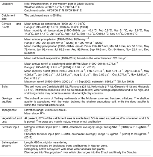
An additional bonus for the selection of the site is that runoffmeasurements at the catchment outlet started in 1945 (Blümel und Klaghofer, 1977; Turpin et al., 2006; Strauß et al., 2007) which helps put the recent observations into a longer term context.
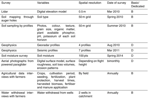
3.1.2 Catchment description 10
The Petzenkirchen HOAL (Hydrology Open Air Laboratory) catchment is situated in the western part of Lower Austria (48◦9′N, 15◦9′E) (Fig. 2). The catchment area at
the outlet (termed MW) is 66 ha. The elevation of the catchment ranges from 268 to 323 m a.s.l. with a mean slope of 8 %. At present, 87 % of the catchment area is arable land, 5 % is used as pasture, 6 % is forested and 2 % is paved. The crops are mainly
15
winter wheat and maize.
The climate can be characterised as humid with a mean annual temperature of 9.5◦C
and a mean annual precipitation of 823 mm yr−1from 1990 to 2014. Precipitation tends
to be higher in summer than in winter (Fig. 3, Table A1). Crop evapotranspiration (ETc)
estimated by the FAO (1998) method using local climate data and crop growth
infor-20
mation for this period was 471 mm yr−1. Annual evaporation estimated by the water
balance ranged from 435 to 841 with a mean of 628 mm yr−1(1990–2014). The natural
surface water outlet of the catchment is known as the Seitengraben stream. Mean an-nual flow from the catchment in this stream is 4.1 L s−1(or 195 mm yr−1) (1990–2014).
Mean flows tend to peak in the spring (Fig. 3). The largest flood events on record
oc-25
curred in 1949 and 2002 with estimated peak discharges of 2.8 and 2.0 m3s−1,
respec-tively. The highest discharge in recent times occurred in summer 2013 with 0.66 m3s−1.
silt-HESSD
12, 6683–6753, 2015The Hydrological Open Air Laboratory
(HOAL) in Petzenkirchen
G. Blöschl et al.
Title Page
Abstract Introduction
Conclusions References
Tables Figures
◭ ◮
◭ ◮
Back Close
Full Screen / Esc
Printer-friendly Version
Interactive Discussion
Discussion
P
a
per
|
Discussion
P
a
per
|
Discussion
P
a
per
|
Discussion
P
a
per
|
stone. The dominant soil types are Cambisols and Planosols with medium to poor infiltration capacities. Gleysols occur close to the stream (Fig. 4).
The HOAL is special in that many runoffgeneration mechanisms can be observed simultaneously in different parts of the catchment (Fig. 5). Due to shallow, low perme-able soils and the use of the catchment area as agricultural land, the concave part of
5
the catchment was tile drained in the 1950s in an effort to reduce water logging. The estimated drainage area from the tile drains is about 15 % of the total catchment and can be divided into two bigger systems in the south-western part of the catchment and four smaller drainage systems in the north-eastern part. The pipes drain into the main stream at four locations. Two tile drain systems (Sys1, Sys2) do not dry out during the
10
year while two are ephemeral (Frau1, Frau2) (see Fig. 7). The uppermost 25 % of the stream was piped in the 1950s to enlarge the agricultural production area. The pipe enters the main stream at inlet Sys4. Its flow dynamics and chemistry are similar to those of the permanent tile drains as it drains the surrounding soil.
There are two clearly visible springs that directly discharge into the stream. These
15
are Q1 and K1. The water from Q1 originates from a fractured siltstone aquifer with dis-tinct hydrologic and chemical characteristic from those of other point sources along the stream. The hydrologic dynamics and chemical characteristics of K1 are more similar to the perennial tile drainages. Q1 is perennial, while K1 is not.
In the south-eastern part of the catchment is a small wetland close to the stream
20
which permanently seeps into the stream via two rivulets (A1, A2). The wetland is fed by springs at the upper part of the wetland and usually responds very quickly to all types of rainfall due to its high saturation state.
During low intensity events in summer, the flow in the main stream responds to rain-fall with substantial delay as the soil usually offers a lot of storage capacity, depending
25
HESSD
12, 6683–6753, 2015The Hydrological Open Air Laboratory
(HOAL) in Petzenkirchen
G. Blöschl et al.
Title Page
Abstract Introduction
Conclusions References
Tables Figures
◭ ◮
◭ ◮
Back Close
Full Screen / Esc
Printer-friendly Version
Interactive Discussion
Discussion
P
a
per
|
Discussion
P
a
per
|
Discussion
P
a
per
|
Discussion
P
a
per
|
two (E1, E2) or three locations, depending on the magnitude of the event. The overland flow causes gully erosion.
During high intensity thunderstorms in summer and spring, infiltration excess over-land flow tends to occur with a very substantial, fast contribution from the tile drainage system. During infiltration excess overland flow events, splash and gully erosion may
5
occur on the fields that are poorly covered by crops (such as bare soil after harvest or the adolescence state of maize), but sedimentation immediately occurs when the sediment laden water enters a field with better cover (such as wheat). During very dry periods in summer, the high clay contents will cause shrinking cracks which act as macropores for re-infiltration during subsequent events.
10
In winter rain-on-snow runoff may occur as saturation overland flow during large events leading to gully erosion. In fact, this is when most of the overland flow oc-curs during the year. However, the main runoff generation mechanism in winter is through lateral subsurface pathways (shallow subsurface preferential flowpaths, drainage pipes). Even minor events (of, say, 5 mm) will lead to a significant increase of
15
stream flow due to high soil moisture during the winter. After freezing periods, when the soil is still frozen, infiltration excess overland flow may occur.
3.2 Setting up the HOAL and instrumentation
Setting up the base monitoring and the dedicated monitoring and sampling was guided by the overarching science questions and the specific hypotheses.
20
3.2.1 Basic infrastructure and monitoring
Planning of the HOAL started in 2008. In September 2009 the Vienna Doctoral Pro-gramme on Water Resource Systems started and the financial resources for the base instrumentation were made available through the TU Wien. In line with the overarch-ing science questions the instrumentation was designed for high spatial and temporal
25
ca-HESSD
12, 6683–6753, 2015The Hydrological Open Air Laboratory
(HOAL) in Petzenkirchen
G. Blöschl et al.
Title Page
Abstract Introduction
Conclusions References
Tables Figures
◭ ◮
◭ ◮
Back Close
Full Screen / Esc
Printer-friendly Version
Interactive Discussion
Discussion
P
a
per
|
Discussion
P
a
per
|
Discussion
P
a
per
|
Discussion
P
a
per
|
ble was run from the nearest connector a few hundred meters outside the catchment along the stream to the weather station to enable 380 V electric power supply to the instruments. To facilitate maintenance of the instruments, data storage and the short term planning of experiments, a high speed glassfibre cable was run from the premises of the Institute for Land and Water Management Research into the HOAL to provide
5
a Local Area Network (LAN) for data transmission. The glassfibre network allows fast streaming of the data and is less susceptible to damage due to lightening than electri-cal transmission lines. Subsequently, a range of instruments was installed as the basic monitoring setup to measure dynamic data. All are operated at a temporal resolution of 1 min with the exception of the piezometers where groundwater levels are recorded
10
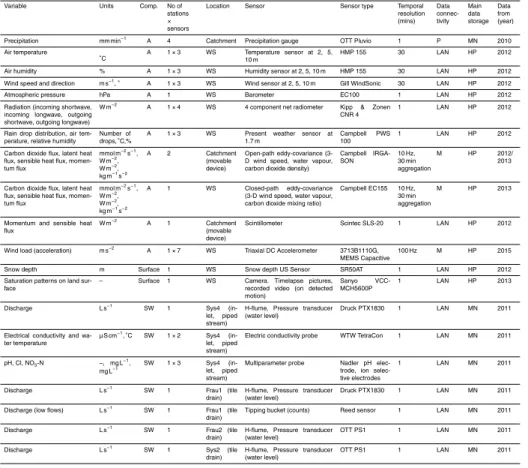
at temporal resolutions of 5 to 30 min.
– Atmospheric processes: four raingauges were installed to monitor spatial rainfall patterns. Three of the raingauges are distributed within the catchment and one is located close to its boundary.
– Atmospheric and soil processes: monitoring at the weather station located
ap-15
proximately in the centre of gravity of the catchment includes air temperature, air humidity, wind speed and direction (all at three heights), incoming and outgoing solar and long wave radiation, wind load on the construction, rain drop size distri-bution, snow depths, soil heat flux and soil temperatures at different depths.
– Surface water: a total of 12 flumes were installed within the catchment to monitor
20
discharge at 1 min resolution from the inlet piped stream, tile drains, erosion gul-lies, springs and tributaries from wetlands. These flumes are the backbone of the HOAL. All flumes were calibrated in the Hydraulic Laboratory of the TU Wien to obtain a reliable stage–discharge relationship.
– Surface water: at the catchment outlet, the existing H-flume (dating from 1945
25
HESSD
12, 6683–6753, 2015The Hydrological Open Air Laboratory
(HOAL) in Petzenkirchen
G. Blöschl et al.
Title Page
Abstract Introduction
Conclusions References
Tables Figures
◭ ◮
◭ ◮
Back Close
Full Screen / Esc
Printer-friendly Version
Interactive Discussion
Discussion
P
a
per
|
Discussion
P
a
per
|
Discussion
P
a
per
|
Discussion
P
a
per
|
makes), chloride, pH, nitrate. Grab samples are taken weekly for a range of chem-ical analyses including suspended solids and various compounds of nutrients. Ad-ditionally, autosamplers take water samples during events. A video camera was installed to monitor the water level in the flume and the functioning of the instru-ments.
5
– Groundwater: 23 piezometers were installed within the catchment where ground-water level and ground-water temperature are monitored. Most of the piezometers are located along transects perpendicular to the stream to help understand stream– aquifer interactions. Two additional air pressure sensors were needed to correct the readings of the pressure transducers for the air pressure fluctuations.
10
Tables 1 and B1 give more details of the instruments. All of these instruments are con-nected to data loggers (some of them through interfaces) where the data are stored temporarily. Most of the data loggers are then directly connected to a computer at IKT through the glassfibre LAN. These include the loggers of the discharge pressure trans-ducers, the turbidity measurements, the water chemical parameters and the
instru-15
ments at the weather station. The rain gauges are connected through a GSM (mobile phone) module. The data of the piezometers and the movable eddy correlation stations are stored locally and read out manually at regular intervals.
To complement the base monitoring of the dynamics of the hydrological flow and transport processes at specific locations, a number of spatial surveys were conducted
20
after setting up the HOAL which included a Lidar survey, aerial photographs, soil map-ping and sampling, and collection of agricultural data (Table 2). Further details are given in Tables B1 and B2, Figs. 6 and 7.
3.2.2 Dedicated monitoring and experiments
Three eddy correlation stations were set up in 2012 and 2013 to understand the
spa-25
HESSD
12, 6683–6753, 2015The Hydrological Open Air Laboratory
(HOAL) in Petzenkirchen
G. Blöschl et al.
Title Page
Abstract Introduction
Conclusions References
Tables Figures
◭ ◮
◭ ◮
Back Close
Full Screen / Esc
Printer-friendly Version
Interactive Discussion
Discussion
P
a
per
|
Discussion
P
a
per
|
Discussion
P
a
per
|
Discussion
P
a
per
|
research questions. One set of instruments has been set up at the weather station lo-cation, using a closed path device. Additionally, two mobile stations are deployed (using open path devices) based on a site rotation plan to optimise the locations for each sen-sor relating to the factors of interest; topography, soil type and moisture and vegetation. The devices measure at a frequency of 10 Hz and are processed offline using TK3
soft-5
ware (Mauder and Foken, 2011) to provide 30 min values for the sensible, latent heat and CO2fluxes. The height at which the devices are installed varies depending on the height of the surrounding vegetation to try to ensure the footprint contains only one par-ticular land use. Soil heat flux and net radiation sensors are also installed to complete the energy balance. Scintillometer measurements of aggregated fluxes over a line of
10
about 150 m are made for comparison to obtain momentum flux, sensible heat flux and information on the turbulent parameters of the air. The evapotranspiration can also be calculated using energy balance measurements from the mobile eddy stations.
Acceleration sensors (Accelerometers) are installed on the guyed mast of the weather station to evaluate the fatigue of water related structures caused by the
fluctu-15
ating components of wind. For the elements of steel structures (such as poles of water supply towers) fatigue damages due to the high cyclic wind-induced vibration is a rele-vant failure mechanism. To this end, a finite element model of the structure is verified by dynamic system identification and the measured structural responses are used to extract the stress/strain time histories at critical points. The measurement duration of
20
the capacitive accelerometers was set to 30 min at a 100 Hz sampling rate that repeats every 18 h. Another step is to identify the wind loads inversely from the measured struc-tural response and correlate them to the wind statistics from eddy correlation measure-ments. The wind load identification follows the general lines of the experiments already accomplished at the TU Wien Laboratory of structural model dynamics (Kazemi and
25
Bucher, 2015).
HESSD
12, 6683–6753, 2015The Hydrological Open Air Laboratory
(HOAL) in Petzenkirchen
G. Blöschl et al.
Title Page
Abstract Introduction
Conclusions References
Tables Figures
◭ ◮
◭ ◮
Back Close
Full Screen / Esc
Printer-friendly Version
Interactive Discussion
Discussion
P
a
per
|
Discussion
P
a
per
|
Discussion
P
a
per
|
Discussion
P
a
per
|
patterns will also be useful to other processes in the HOAL including evapotranspiration and runoffgeneration. The network uses wireless transmission technology based on the ZigBee protocol (Bogena et al., 2010) where the local data are telemetered to hubs which connect to the LAN. Time Domain Transmission sensors are used which measure the dielectric conductivity from the propagation velocity of an electromagnetic
5
wave, similar to TDR (Bogena et al., 2010). All sensors are installed at four depths below ground surface (two stations at five depths). One of the difficulties with measuring soil moisture in agricultural catchments is that it is not possible to install the sensors permanently in the field. As a consequence, 20 stations were installed permanently on pasture, while 11 stations were temporary, which were removed and replaced once or
10
twice a year in accordance with the agricultural manipulations on the fields.
Monitoring of saturation patterns within the catchment is conducted using video cam-era to understand the space–time patterns and connectivity of surface flow following the pattern comparison paradigm of Blöschl et al. (1991) and Parajka et al. (2012). This is complementary to the soil moisture network by providing visual observation with better
15
spatial resolution. For these observations, a two megapixels HD camera was installed on the weather station mast 7 m above the ground, overlooking a hillslope area of about 2 ha. The camera captures one 1280×720 resolution picture per minute and records
720P video by motion-trigger during rainfall events. The camera exterior orientation was determined based on 15 ground targets for georeferencing. Pictures of overland
20
flow generation provide a visual assessment of saturation patterns and are useful for validating distributed models of surface runoff (Grayson et al., 2002; Horvath et al., 2015).
To understand the dynamics of nutrients such as phosphorus and nitrogen and their compounds a water quality monitoring network was installed at the tributaries within
25
HESSD
12, 6683–6753, 2015The Hydrological Open Air Laboratory
(HOAL) in Petzenkirchen
G. Blöschl et al.
Title Page
Abstract Introduction
Conclusions References
Tables Figures
◭ ◮
◭ ◮
Back Close
Full Screen / Esc
Printer-friendly Version
Interactive Discussion
Discussion
P
a
per
|
Discussion
P
a
per
|
Discussion
P
a
per
|
Discussion
P
a
per
|
in the HOAL facilitated the sediment process analyses, they turned out to be a chal-lenge for monitoring the water quality parameters, as the stilling wells in which sen-sors are usually placed tended to silt up quickly. A new device was developed, termed Water Monitoring Enclosure (WME), that allows in-situ monitoring of water quality pa-rameters for highly dynamic, sediment laden streams (Exner-Kittridge et al., 2013).
5
The WME ensures a minimum internal water level which keeps the monitoring equip-ment submerged even when there is no flow into the enclosure. Four WME and six autosamplers were installed throughout the catchment for event sampling. Grab sam-pling is performed monthly at the tributaries, in addition to the weekly samsam-pling at the catchment outlet, and analysed for a range of parameters including stable isotopes.
10
Four enzymatic analysers have been set up at the catchment outlet to understand the dynamics and pathways of faecal pollution and to test the instruments for real-time surface water monitoring. The devices have two different designs (BACTcontrol and ColiMinder) both of which detect the enzymatic activity ofβ-D-glucuronidase (GLUC) occurring in faecal associated microbes. The measurement principle is based on the
15
enzymatic hydrolyses of a non-fluorescent substrate that leads, depending on the con-centration and activity of the target GLUC enzymes, to the accumulation of a fluores-cent product which is detected optically. The devices sample stream water at intervals of 1 or 3 h. The results from the devices are compared for different setups with lab-oratory analyses of water samples to understand the strengths and limitations of the
20
instruments in an on-line mode, and interpreted in the context of a range of physical and chemical parameters for events with contrasting characteristics (e.g. fast and short response times, dry and wet antecedent soil moisture) to shed light on the processes of microbial pollution.
Sediment monitoring and experimentation was conducted to understand the sources
25
inves-HESSD
12, 6683–6753, 2015The Hydrological Open Air Laboratory
(HOAL) in Petzenkirchen
G. Blöschl et al.
Title Page
Abstract Introduction
Conclusions References
Tables Figures
◭ ◮
◭ ◮
Back Close
Full Screen / Esc
Printer-friendly Version
Interactive Discussion
Discussion
P
a
per
|
Discussion
P
a
per
|
Discussion
P
a
per
|
Discussion
P
a
per
|
tigate subsurface sediment transport. Aerial photographs are taken to identify erosion patterns and calculate eroded soil volumes after erosive rainfall events. To understand sediment deposition and resuspension in the stream, flushing experiments were con-ducted, where sediment-free water was pumped into the source of the stream and flow rates, sediment and solute concentrations as well as grain size distributions were
5
measured (Eder et al., 2014).
To understand the stream–aquifer interactions several stream tracer tests were per-formed in the main stream. One set of tracer experiments was perper-formed during winter baseflow conditions (where evaporation can be assumed to be negligible). Bromide was injected as a tracer and bromide concentrations and flow were measured for five
10
locations along the stream. This allowed the estimation of stream bank fluxes (Exner-Kittridge et al., 2014). An infrared camera was used to identify hotspots of groundwa-ter recharge into the stream. Similar tracer tests were performed during summer with the additional focus on evaporation. Mass balances over sections of the stream were used to determine the role of near-stream riparian trees on the daily fluctuations of the
15
stream flow during low flow conditions.
A number of geophysical surveys were conducted to improve the delineation of hy-drogeological heterogeneities and processes in the subsurface. Initially, a series of measurements using ground penetrating radar (GPR) were performed in 2010 for the characterisation of drainage pipes. However, the resolution of these results was limited
20
due to the high attenuation in the signatures due to the high clay content. To improve the characterisation of the HOAL site at different spatial scales, imaging surveys are being started with the Induced Polarization (IP) method for delineating the aquifer geometry and hydrogeological structures such as preferential flow paths. Application of the spec-tral IP method (SIP) at different frequencies is planned to gain information on hydraulic
25
HESSD
12, 6683–6753, 2015The Hydrological Open Air Laboratory
(HOAL) in Petzenkirchen
G. Blöschl et al.
Title Page
Abstract Introduction
Conclusions References
Tables Figures
◭ ◮
◭ ◮
Back Close
Full Screen / Esc
Printer-friendly Version
Interactive Discussion
Discussion
P
a
per
|
Discussion
P
a
per
|
Discussion
P
a
per
|
Discussion
P
a
per
|
3.3 Managing the HOAL
Meaningful hypothesis testing in an observatory not only requires careful planning of installation of instruments and conducting the monitoring and the experimentation, but also coordination of the research between the groups involved, maintenance of the instruments, dealing with land owners, and data management.
5
3.3.1 Coordination of research
One of the main strengths of this kind of observatory comes from the synergies be-tween a critical group of people conducting related research. In the HOAL, currently more than 20 researchers are involved plus support staff. Nine dissertation projects focussed on the HOAL are being conducted. While observatories sometimes adopt
10
a top-down approach where the individual research activities are subsidiary to the main goal, a slightly different approach has been adopted in the HOAL. A general master plan for the research to be conducted was defined as the overarching sciences ques-tions. These were specified in the research proposals of the Doctoral Programme on Water Resource Systems that were submitted to the Austrian Science Funds (Blöschl
15
et al., 2012). The research proposals also included more specific hypotheses. When actually implementing the research, the individual doctoral students were given consid-erable freedom in specifying their own hypotheses and their experimental/monitoring setups. This then led to an iterative network structure of the interactions between the research of the students. Figure 8 illustrates the general concept of implementation.
20
For each hypothesis, the individual steps of implementation consisted of (i) planning of the dedicated monitoring and experiments, (ii) conducting monitoring and experiments, (iii) data analysis and hypothesis testing, and (iv) research write up. Depending on the outcomes of the experiments, these steps would be repeated in an iterative way. At the same time other hypotheses are tested in the HOAL (by the same or other students).
25
HESSD
12, 6683–6753, 2015The Hydrological Open Air Laboratory
(HOAL) in Petzenkirchen
G. Blöschl et al.
Title Page
Abstract Introduction
Conclusions References
Tables Figures
◭ ◮
◭ ◮
Back Close
Full Screen / Esc
Printer-friendly Version
Interactive Discussion
Discussion
P
a
per
|
Discussion
P
a
per
|
Discussion
P
a
per
|
Discussion
P
a
per
|
this iterative, network-based process of conducting hypothesis testing are its flexibility and the encouragement of creative thinking by the students.
The Doctoral Programme on Water Resource Systems is an ideal setting for this exchange as it is specifically geared towards fostering collaboration between students, including from different disciplines. As part of the Doctoral Programme, each student
5
is encouraged to develop collaborations through joint supervision (each student has two supervisors), regular research cluster meetings focusing on research themes, and annual and six-monthly symposia that bring all research students and supervisors to-gether for one or two days for research presentations, posters and discussion sessions.
3.3.2 Maintenance of instruments 10
The overall responsibility of coordinating the maintenance of the instruments lies with the HOAL manager who draws the maintenance plans and coordinates or supports any repairs and replacements. The manager also coordinates the installation of new instrumentation and the setup of experiments. An important part of the maintenance work relates to the base monitoring, and in particular the cleaning of the H-flumes
15
at the stream tributaries. Some of the water quality sensors need regular cleaning to avoid biofilm formation and calcification. The sensors on the weather station are checked regularly for level position and cleanliness. The soil moisture sensors and the other sensors that are not connected to the power grid are checked regularly for power supply (change of batteries, cutting out grass to prevent solar panels from being
20
overgrown). A regular schedule of checking the instrumentation is operated. In these tasks, the HOAL manager is assisted by a number of local technicians with diverse expertises, including electronics.
Generally, each student is responsible for the proper set up and operation of any dedicated monitoring and experimentation for their PhD research. There is, again,
25
HESSD
12, 6683–6753, 2015The Hydrological Open Air Laboratory
(HOAL) in Petzenkirchen
G. Blöschl et al.
Title Page
Abstract Introduction
Conclusions References
Tables Figures
◭ ◮
◭ ◮
Back Close
Full Screen / Esc
Printer-friendly Version
Interactive Discussion
Discussion
P
a
per
|
Discussion
P
a
per
|
Discussion
P
a
per
|
Discussion
P
a
per
|
One of the main advantages of the HOAL is its location within walking distance of the premises of the Institute for Land and Water Management Research which vastly fa-cilitates the day-to-day maintenance of the instruments and experimental setups. Both the HOAL manager and the local technicians are based at the Institute. Heavy rainfall events can be observed live and reference measurements can be taken during events.
5
The operation of the auto samplers can be checked during events, to maximise the number of water samples from an event. After events associated with lightening the entire system is checked for operation (e.g. power outages).
To facilitate the exchange of information between the team members, a web-logbook has been specifically created for the HOAL. All activities within the HOAL are entered
10
into the logbook including installation and maintenance of instrumentation, all sampling and surveying activities, and any other activities that are relevant to the operation of the HOAL. The web-logbook is a web application that allows access anywhere anytime by simply using a web browser. The main advantage of the logbook is that it sets a minimum standard protocol for all the information relevant to operating the HOAL
15
and its easy, instantaneous accessibility to all team members. The logbook is often accessed in the field during manual measurements. The software also features user management, search and import/export facilities.
3.3.3 Land owners
Observatories in most other geoscience disciplines, such as astronomy and
meteorol-20
ogy, require relatively modest space on the land. Typically, the land is purchased by the operators of the observatory. In contrast, hydrology is about water and matter fluxes at the landscape scale, so the requirements regarding space are invariably more exten-sive and purchasing the entire catchment of interest is rarely an option. Arrangements have therefore to be made between the operators of the observatories and the land
25
owners. The arrangements in the HOAL involve:
HESSD
12, 6683–6753, 2015The Hydrological Open Air Laboratory
(HOAL) in Petzenkirchen
G. Blöschl et al.
Title Page
Abstract Introduction
Conclusions References
Tables Figures
◭ ◮
◭ ◮
Back Close
Full Screen / Esc
Printer-friendly Version
Interactive Discussion
Discussion
P
a
per
|
Discussion
P
a
per
|
Discussion
P
a
per
|
Discussion
P
a
per
|
– Information on agricultural management practices and, where applicable, changes to these practices.
Permissions to use land are needed for the permanent instrumentation (such as the weather station) as well as to access the fields for sampling and for the temporary sensors of the soil moisture network. Information on agricultural management practices
5
is particularly important for estimating nutrient input and it is also very relevant for estimating other fluxes such as transpiration. In a number of instances specific tillage practices are part of hillslope experiments.
Agreements have been drawn up between the HOAL management and the landown-ers to make arrangements for both aspects. About half the land is privately owned by
10
a total of nine farmers. The remaining land is state owned and management by the Austrian agricultural research agency, which facilitates the collaboration with the HOAL team due to similar objectives. A small fee is paid as part of the agreement but, more importantly, a good working relationship is always sought. Any maintenance or experi-mentation activities in the field are planned in agreement with the land owners, in order
15
to avoid obstructions of the daily agricultural routines. The HOAL manager makes an effort to introduce the doctoral students and their research to the farmers on site, e.g. when they meet by chance during sensor installations or field work. The farmers are given access to the weather data, which is generally appreciated. They also get Christ-mas presents and there is an annual open day where the students explain their recent
20
research to the local community. The main source of income of the farms in the catch-ment is crop production for fodder for pig breeding. Fertilizers costs and fertilizer leach-ing as well as the problem of soil loss by erosion are important tasks farmers have to deal with. This makes them additionally interested in the research and the cooperation.
3.3.4 Data management 25
HESSD
12, 6683–6753, 2015The Hydrological Open Air Laboratory
(HOAL) in Petzenkirchen
G. Blöschl et al.
Title Page
Abstract Introduction
Conclusions References
Tables Figures
◭ ◮
◭ ◮
Back Close
Full Screen / Esc
Printer-friendly Version
Interactive Discussion
Discussion
P
a
per
|
Discussion
P
a
per
|
Discussion
P
a
per
|
Discussion
P
a
per
|
is run on the IKT server and hosts most of the data. Mydatanet imports the data at 1 min intervals from the data loggers along the stream (discharge and water chemistry parameters) and the rain gauges. Mydatanet features online access and a web-based graphical interface (Fig. 9) to the database which allows a regular check of data and fast identification of specific hydrologic situations and instrumentation failures. Mydatanet
5
also provides for easy importing and downloading, user management, device adminis-tration and reporting.
Some sensors are connected through fast glassfibre LAN to dedicated computers. For example, the sensors of the weather station are connected to the HOAL PC, the sensors of the soil moisture network to the Soil Net PC where they are stored as files.
10
Some data (such as the eddy correlation data) are read out manually from the data loggers and uploaded on the data bases on the dedicated computers.
All measured data are stored as two separate layers. The first contains raw data as directly obtained by the instruments. These data are regularly screened for errors and inconsistencies. They are corrected or labelled as missing data according to a set
15
protocol. The corrected data are stored in the second layer with data flagging and a pro-cessing report. Data quality check is an important step in data management not only for scientific usage of the data, but also for providing a direct feedback to maintaining and updating instrumentation configurations. All raw and processed data are exported from the various databases and uploaded in consistent CSV file format to an ftp server at TU
20
Wien at bimonthly (raw data) and six-monthly (processed data) intervals. A backup of all data is performed on a daily basis by the grandfather–father–son method. Monthly backups of all databases are kept for one year.
The HOAL manager is responsible for the overall data management process. Two IT professionals (one at IKT, one at TU Wien) are responsible for the back up of the
25
HESSD
12, 6683–6753, 2015The Hydrological Open Air Laboratory
(HOAL) in Petzenkirchen
G. Blöschl et al.
Title Page
Abstract Introduction
Conclusions References
Tables Figures
◭ ◮
◭ ◮
Back Close
Full Screen / Esc
Printer-friendly Version
Interactive Discussion
Discussion
P
a
per
|
Discussion
P
a
per
|
Discussion
P
a
per
|
Discussion
P
a
per
|
4 Examples of specific hypotheses
Currently, nine research students are conducting their PhD in the HOAL. Based on the literature and previous work in the HOAL the students identify specific hypotheses within their research programmes. Typically, one hypothesis conforms to one research paper they are planning to prepare, but sometimes the hypotheses are more specific.
5
The following steps were adopted in inferring the instrumentation or experimental setup from the hypothesis to be tested.
– Background: importance of the research issue, prior knowledge of the issue and specific research question. In many instances the specific hypotheses are for-mulated and tested as a collaboration among students (joint science questions)
10
building on previous work.
– Hypothesis: stating the hypothesis from knowledge of the processes in the litera-ture and prior analyses in the catchment.
– Test: anticipating alternative test results and their implications for rejecting (or not rejecting) the hypothesis. If possible, more than one test is performed to test the
15
same hypothesis, preferably based on different data and/or different rationales.
– Experiment: performing the experiment or the monitoring with required sensitivity.
– Outcomes: testing the hypothesis against the results of the experiment or the monitoring in the context of the assumptions involved and implications for the overarching science questions.
20