Abstract — In almost all literature about propagation models through vegetated environments, path loss hasbeen proposed based on specimens of temperate clime conditions. In this work, a new propagation model is proposed, based on measurements, carried out on vegetated environments with tropical specimens. These environments are common on suburban and rural areas in Brazil. Current models have presented pessimistic approach to propagation loss in these areas. The vegetal morphology and frequency effects, transmission height and distance are taken into consideration. Finally a comparison with existing models is presented.
Index Terms— Path Loss over vegetated environments, UHF Propagation Model, Radio communication fading.
I. INTRODUCTION
There is a great interest in fading and attenuation of electromagnetic signals associated with vegetated environments at low UHF frequencies. However it remains under exploited in the literature [1].
The 700 – 800 MHz band has been proposed in several countries to use on new communications technology, due to its very good propagation condition [2], leading to better signal coverage with less energy cost. In Brazil this is a very important issue and new 5G communication systems are being proposed to cope with the growing demand. The goal of this paper is to develop a prediction model for the signal attenuation due to the presence of typical tropical vegetal morphologies in the environments, using an empirical mathematic model.
The problem of vegetated environment propagation has a great practical interest and it is considered a very complex propagation problem. The propagating wave experience absorption, scattering attenuation and depolarization and these aspects are related with frequency, atmospheric conditions, antenna height, electric properties of the medium, density and morphology of the vegetation specimens. The large amount of aspects makes the problem a very intricate to solve, since they introduce randomness and non-linearity. Vogel e Goldhirsh [3] demonstrated that an isolated tree can attenuate 10 dB the electromagnetic field. This motivates an empirical approach, based on measured data. In order to accomplish that, an extensive measurement campaign was carried out on the band of
Propagation Model for Path Loss Through
Vegetated Environments at 700 – 800 MHz
Band
J. C. Silva1, G. L. Siqueira2, P. V. G. Castellanos3
Centro de Estudos em Telecomunicações – CETUC, Pontifical Catholic University of Rio de Janeiro, PUC-Rio. Rua Marquês de são Vicente, 225, Gávea, Rio de Janeiro, Brazil. Contacts: (1) [email protected],
interest. The methodology, proposed on [1] and [4] was used, and the measurement sites was on two spots: lines of trees (vegetation disposed over the walking sidewalk, typical of brazilian cities) and small wood or a suburban city park.
II. PROBLEM DESCRIPTION AND METHODOLOGY
In built up areas, the edifications produce signal variations due to wave scattering. On vegetated environments, the trees can be characterized as such causing scattering and attenuation of the signal. According with Jao [5], it is possible to consider the vegetation as a randomly distributed medium with different kinds of trees. There is a great vegetal diversity, making its characterization difficult. However, due to the low attenuation produced by grassy and bushes, the characterization effort on this work will be concentrated over arborized environment, which play the major role in path loss.
The characterization of the vegetation was a simplified form of the methodology presented by Kafaru [6], where the area is divided into squares, with specific morphology that includes density size and type of trees. Dal Bello [7] has extended this idea in order to have a more qualified appreciation of the environment vegetation.
A series of measurements routes were selected on the two types of considered morphologies. For each chosen route, the Tx is fixed and the measurements were carried out changing the position of the Rx and using a GPS to measure the distance. In order to produce a better characterization on the frequency band, measurements were collected in 700, 750 and 800 MHz. Tx antenna heights were 1.5, 6.0 and 12.0 m, while the Rx antenna was 1.5 m. Next, the collected dataset was be used to produce a path loss propagation model, with an interpolation formalism.
III. RELATED LITERATURE
A. Weissberger and Related Models
Weissberger [8], proposed a propagation loss model known as modified exponential model, from his analysis of exponential decay at the frequency range of 230 MHz to 96 GHz. The model is valid for propagation paths obstructed by trees with dry leaves found in temperate clime as proposed in Fig. 1, below.
Fig. 1. Propagation in Canopy, d.
The propagation loss can be expressed as:
{𝐿 (𝑑𝐵) = 0.45𝑓
0.284𝑑 , 𝑓𝑜𝑟 𝑑 ≤ 14 𝑚𝑒𝑡𝑒𝑟𝑠
with the frequency f in GHz and d, the path inside the trees, in meters.
About 1988, The International Telecommunication Union (ITU), developed a propagation loss model for vegetated paths using Weissberger’s same technique. This model is known as early ITU model, and it is expressed by:
𝐿(𝑑𝐵) = 0.2𝑓0.3𝑑0.6
(2) Lately, the ITU has released a model, called Fitted ITU-R (FITU-R) that was proposed by Al-Nuaimi et al. [9] in 1998. In this model the frequency range is from 10 to 40 GHz but now considering trees with and without leaves:
{ 𝐿 (𝑑𝐵) = 0.39𝑓
0.39𝑑0.25 , 𝑤𝑖𝑡ℎ 𝑙𝑒𝑎𝑣𝑒𝑠
𝐿 (𝑑𝐵) = 0.37𝑓0.18𝑑0.59 , 𝑤𝑖𝑡ℎ𝑜𝑢𝑡 𝑙𝑒𝑎𝑣𝑒𝑠 (3)
A very popular model is the COST 235 [10], which also considers foliage as a parameter, and is given by:
{ 𝐿 (𝑑𝐵) = 15.6𝑓
−0.009𝑑0.26 , 𝑤𝑖𝑡ℎ 𝑙𝑒𝑎𝑣𝑒𝑠
𝐿 (𝑑𝐵) = 26.6 𝑓−0.2𝑑0.5 , 𝑤𝑖𝑡ℎ𝑜𝑢𝑡 𝑙𝑒𝑎𝑣𝑒𝑠
(4)
with f in MHz and d in meters. B. Chen and Kuo Model
In the beginning of the 1990´s, Chen and Kuo [11] addressed the propagation loss in forested environments using measurements in the 1 to 100 GHz band. They have proposed a model based on Geometric Theory of Diffraction and the medium was modeled by four layers: air, canopy, tree trunks and soil. They have done measurements spaced by 10 meters using both vertical and horizontal polarizations. The expressions are given by:
𝐿𝑣= (0.001𝑓 + 0.2)𝑑 + 0.5𝑓 + 3 , 𝑣𝑒𝑟𝑡𝑖𝑐𝑎𝑙 𝑝𝑜𝑙𝑎𝑟𝑖𝑧𝑎𝑡𝑖𝑜𝑛; (5)
𝐿ℎ= (0.0002𝑓 + 0.2)𝑑 + 0.03𝑓 + 2 , ℎ𝑜𝑟𝑖𝑧𝑜𝑛𝑡𝑎𝑙 𝑝𝑜𝑙𝑎𝑟𝑖𝑧𝑎𝑡𝑖𝑜𝑛. (6)
IV. MEASUREMENT SETUP
In order to carry out the measurement campaign, an UHF setup was mounted, covering the frequency band of interest in this work. It includes two blocks:
A. Transmission Block
B. Reception Block
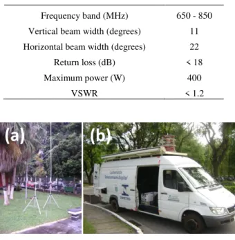
Consists of a Rx antenna, a low noise amplifier (LNA) and a spectrum analyzer Anritzu model MS2692A. A GPS system Garmin E-trex is used to measure the receiver position. Other equips include a Tx antenna mast with height up to 12 meters, Rx tripod of 1.5 meters height and a mobile telecom laboratory, provided by INMETRO (National Institute of Metrology, Quality and Technology) as showed in Fig. 2.
TABLE I.TX AND RX CHARACTERISTICS
Frequency band (MHz) 650 - 850 Vertical beam width (degrees) 11 Horizontal beam width (degrees) 22 Return loss (dB) < 18
Maximum power (W) 400
VSWR < 1.2
Fig. 2. (a) Rx and Tx poles, (b) digital telecom mobile lab.
V. MEASUREMENT SITES AND CAMPAIGN
A. Line of Trees
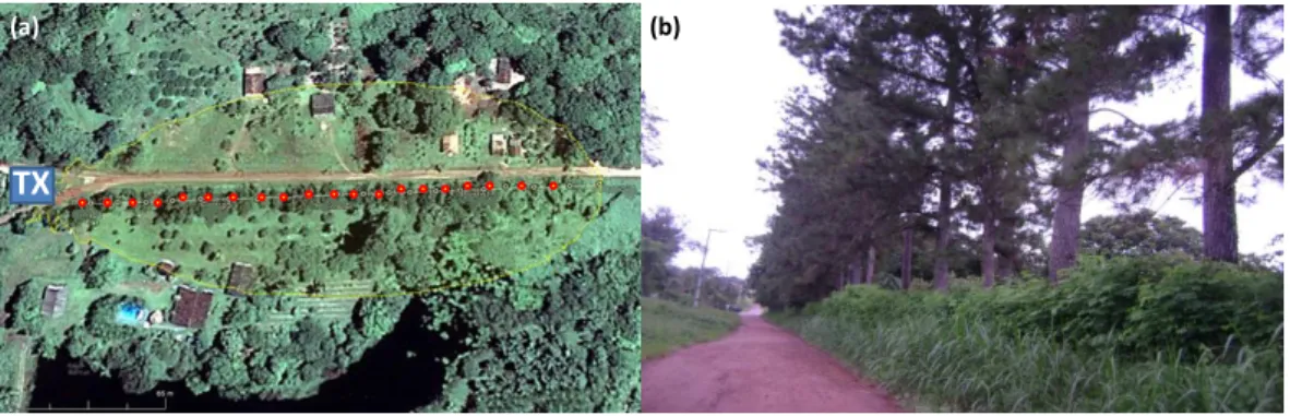
The data of this morphology were collected in Americano, Pará state. The measurement points were selected between the trees taken on regular intervals identified by the GPS. The antenna main beam was positioned in such a way that the line of sight would point toward all the trees on the line. The line of Pinheiro-bravo (Pinus pinnaster) follows a trail road with no traffic over a common flat ground. The trees have height of about 20 m, trunk diameter of 50 centimeters and mean trunk height of 3.8 meters and are uniformly spaced by 4 meters. The measurement was repeated for each frequency and each transmission antenna height. This site was chosen due to the presence of a classical line of trees, similar to the vegetation present on sidewalks over streets on suburban environments. However, have no close edifications.
The transmitter antenna was placed at coordinates 1°25'43.4" S and 48°27'16.5” W, lat. and long., respectively. The transmitter antenna main lobe is pointed to 89 degrees related to the geographic north as showed in Fig. 3.
B. Suburban Park
This site is very similar to a forest but with small construction and routes in its interior. The trees are located between the routes with a relatively high density. The transmission antenna was placed
outside the park on a building of the Pará University and the transmitted signal travels over a street before the park. The suburban park is the Botanic Garden of Belém city, Pará state. It occupies an entire block and is surrounded by small buildings. A level of man-made noise is presented in this region ranging from -100 dBm to -90 dBm but this have no effect on the power budget of the measurements. The terrain is plane with small interior routes, a few movement of people was observed. This morphology is showed on Fig. 4.
Fig. 3. (a) Tx (blue), measured points (red dots) and main lobe (yellow), (b) line of Pinus pinnaster trees.
Fig. 4. (a) Tx (blue), measured points (red dots) and main lobe (yellow), (b) street view.
C. Campaign
The present work is concentrated to the determination of a model of propagation loss due to the vegetal presence, so, areas with buildings were avoided.
In all measurements the receiver was at 1.5 meters height, related to the ground, characterized as flat. The transmitter was initially installed at a height of 1.5 meters, then 6 meters and then 12 meters. The height variation in the transmitter has the objective of verifying the signal behavior, when propagating in the diverse vegetal structures, such as trunks and canopies. In order to serve as comparison parameter between measured environments, samples of: average height of the trunks, average diameter, predominant species and average canopy height were taken. Vertical polarization was used in the antennas.
The campaign was held in the summer, without rain. For all morphology cases, a CW signal (continuous tone) was emitted at the frequencies of 700 MHz, 750 MHz and 800 MHz with constant power. For each frequency used, measurements were made at each transmitter height, at 20 different distances between the antennas, uniformly spaced in the route, in order to compose the sample space.
(a) (b)
TX
(a) (b)
In field measurements of vegetated areas, each specimen acts as a signal scatter, that can change, slightly, the own position by wind [12]. The randomness and incoherence, together with the obvious difficulty to taking measurements under stationarity conditions, introduce challenges to modeling the problem. A large-scale analysis was carried out, where the median signal behavior was studied, and the samples were taken at predefined distances, taken at one minute, with a sampling rate of 10 per second, which makes 600 sub-samples for each measurement point.
Using the least squares method, interpolation approach and a large amount of data, acquired for all frequencies, transmitter heights and transceptors distance, an empirical model can be proposed for the loss in vegetated environments. For the line of trees site, the model gives:
𝐿(𝑑𝐵) = 121.795 − 0.0062𝑓 − 0.525ℎ𝑡[39.945 − 0.0124𝑓 + 0.0071ℎ𝑡] log 𝑑 + 𝐿𝑝 (7)
and for the suburban park site, the model gives:
𝐿(𝑑𝐵) = 101.57 + 0.0425𝑓 − 0.72ℎ𝑡+ [30.825 + 0.0146𝑓 − 0.102ℎ𝑡] log 𝑑 + 𝐿𝑝 (8)
where 𝑓 is the frequency in MHz, ℎ𝑡 the transmitter height in meters, d is the distance from transmitter on meters and 𝐿𝑝 is an additional loss of 10.29 dB taking into account only when the receiver is close to the tree’s trunk [13]. The ranges of the proposed models are:
{700 𝑀𝐻𝑧 ≤ 𝑓 ≤ 800 𝑀𝐻𝑧46 𝑚 ≤ 𝑑 ≤ 535 𝑚 1.5 𝑚 ≤ ℎ𝑡 ≤ 12 𝑚
Next, the proposed model is compared with the discussed models presented on the beginning of this work. They are: Weissberger, COST 235 and Chen and Kuo. All of them calculate the free space excess loss. Hence, the free space loss is added to each one and trees with leaves are considered.
The Weissberger’s model calculates the free space excess loss for propagation through vegetated environment for frequency ranging from 230 MHz to 96 GHz and distance up to 400 meters. The COST 235 modeling is very similar to the Weissberger, however, it generally has higher losses. Finally, the Chen and Kuo model, which is valid for frequencies greater than 1 GHz, is used in this particular frequency and for vertically polarized waves that were used in this work. The comparative analyses are done for each frequency and transmission antenna heights. It is important to mention that the compared models do not present expression as a function of antenna height.
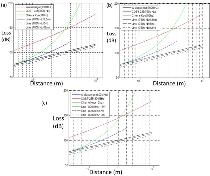
D. Line of Trees
This was the condition where the models have clearly showed less agreement. One of the possible explanations is the space between specimens which can be the reason for the more optimistic behavior of proposed model. Fig. 5 and Table II, shows the comparison results.
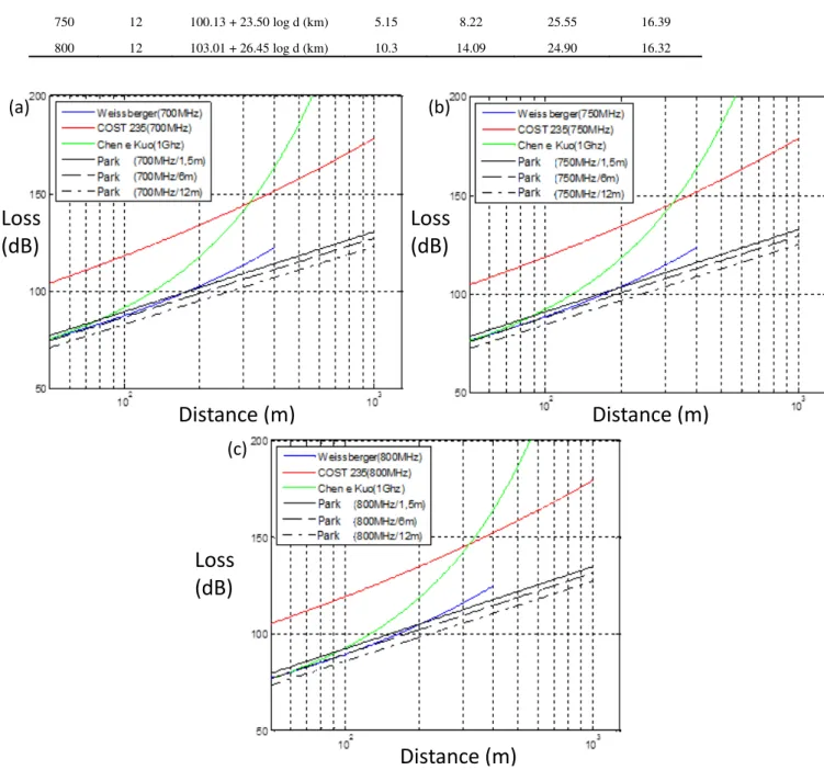
E. Suburban Park
The figures 5 and 6, present curves of the proposed model for all tested frequencies, Tx heights and morphologies. The Weissberger model showed the closest agreement with the proposed model, mainly for the smaller transmitter heights. The COST 235 model is very pessimistic likewise the Chen and Kuo model for distances bigger than 150 meters. However, as already mentioned, Chen and Kuo is proposed to above 1 GHz frequencies, and the loss increases with frequency [14].
Fig. 5. Line of trees: (a) comparisons at 700 MHz, (b) comparisons at 750 MHz and (c) comparisons at 800 MHz.
TABLE II.COMPARISONS AND STATISTICS: LINE OF TREES
Freq. (MHz)
Tx Height (m)
Linear Regression L (dB) Model RMS
Error (dB)
Weissberger RMS Error
(dB)
COST 235 RMS Error
(dB)
Chen e Kuo RMS Error
(dB)
700 1.5 117.73 + 30.78 log d (km) 5.41 7.98 22.13 11.33
750 1.5 121.72 + 32.01 log d (km) 5.57 5.08 19.63 12.19
800 1.5 125.67 + 34.59 log d (km) 4.27 6.1 21.07 17.41
700 6 107.05 + 25.75 log d (km) 7.81 9.77 28.21 12.22
750 6 111.18 + 28.45 log d (km) 6.64 8.17 20.44 15.01
800 6 114.06 + 29.42 log d (km) 8.12 11.21 23.72 14.62
700 12 96.33 + 21.30 log d (km) 6.58 10.45 26.30 13.97
Loss
(dB)
Loss
(dB)
Loss
(dB)
Distance (m)
Distance (m)
Distance (m)
(a)
(b)
750 12 100.13 + 23.50 log d (km) 5.15 8.22 25.55 16.39
800 12 103.01 + 26.45 log d (km) 10.3 14.09 24.90 16.32
Fig. 6. Suburban park: (a) comparisons at 700 MHz, (b) comparisons at 750 MHz and (c) comparisons at 800 MHz.
TABLE III.COMPARISONS AND STATISTICS: SUBURBAN PARK
Freq. (MHz)
Tx Height (m)
Linear Regression L (dB) Model RMS
Error (dB)
Weissberger RMS Error
(dB)
COST 235 RMS Error
(dB)
Chen e Kuo RMS Error
(dB)
700 1.5 133.10 + 41.96 log d (km) 5.70 6.92 19.43 7.80
750 1.5 134.89 + 41.35 log d (km) 5.92 4.12 21.08 9.17
800 1.5 138.47 + 43.10 log d (km) 6.59 5.90 24.33 13.23
700 6 127.59 + 40.46 log d (km) 6.02 6.69 26.50 13.38
750 6 128.44 + 42.53 log d (km) 5.19 7.07 26.02 12.78
800 6 131.18 + 43.17 log d (km) 9.47 8.91 28.19 9.69
700 12 118.42 + 39.30 log d (km) 7.34 10.15 25.89 8.11
750 12 119.43 + 37.71 log d (km) 6.00 7.88 31.05 8.46
800 12 123.14 + 41.24 log d (km) 7.93 8.73 28.48 11.51
Loss
(dB)
Loss
(dB)
Loss
(dB)
Distance (m)
Distance (m)
Distance (m)
(a)
(b)
The comparison models, are very used in calculations of links and quite cited in the literature on propagation in vegetated spaces, however do not uses the transmitter height in its formulation, which introduce difficulties to comparisons.
VI. CONCLUSIONS
This work presents a proposed model for path loss over vegetated environments at the UHF frequency range of 700 to 800 MHz. These frequencies are being considered for 5G mobile systems on suburban areas [15], where the propagation is better than the upper UHF frequencies used on urban environments. These areas are generally covered with vegetation and a line of trees and suburban park morphologies have been studied. The path loss was investigated on each environment as a function of distance, transmission antenna height and frequency.
A model of path loss through vegetation is proposed for two morphologies and comparison with other models have revealed that, although similarities mainly with Weissberger and Chen and Kuo models are evident, for greater distance between Tx and Rx this model has significant differences with the existing ones. This will help the coverage determination of 5G systems. In future work other frequencies and other morphologies will be incorporated to this model.
ACKNOWLEDGEMENTS
Special thanks to: Universidade Federal do Pará (UFPa), Instituto Nacional de Metrologia, Qualidade e Tecnologia (INMETRO)and Coordenação de Apoio ao Pessoal de Ensino Superior (CAPES).
REFERENCES
[1] L. J. Mattos, “Influência da vegetação na dispersão de sinais rádio móveis.” PhD Thesis, Pontifical Catholic University of Rio de Janeiro, Rio de Janeiro, Brazil, 2005.
[2] International Telecommunication Union, Handbook 2 - Terrestrial land mobile radio wave propagation in the VHF/UHF bands, Geneva, Switzerland, 2002.
[3] W. J. Vogel, J. Goldhirsh, “Tree Attenuation at 869 MHz Derived from Remotely Piloted Aircraft Measurements.”
IEEE Trans. Antennas Propag., vol. AP-34, pp. 1460-1464, 1986.
[4] S. Hirofumi, “A Statistical Model for Urban Radio Propagation.” IEEE Trans. on Vehicular Tech., vol. 25, pp. 673-680, 1977.
[5] J. K. Jao, “Amplitude Distribution of Composite Terrain Radar Clutter and K-distribution.” IEEE Trans. Antennas Propag., vol. AP-32, pp 1049-1062, 1984.
[6] O. O. Kafaru, “An Environment - Dependent Approach to Wideband Modeling and Computer Simulation of UHF Mobile Radio Propagation in Built-up Areas.” PhD Thesis, University of Liverpool, UK, 1989.
[7] J. C. R. Dal Bello, “Caracterização da Influência da Vegetação nos Sistemas de Comunicações Móveis Celulares em
Áreas Urbanas.” PhD Thesis, Pontifical Catholic University of Rio de Janeiro, Rio de Janeiro, Brazil, 1998.
[8] M. A. Weissberger, “An initial critical summary of models for predicting the attenuation of radio waves by trees.”
ESD-TR-81-101, EMC Analysis Center, Annapolis, MD, USA, 1982.
[9] M. O. Al Nuaimi, R. B. L. Stephens, “Measurements and prediction model optimization for signal attenuation in vegetated media at centimetric wave frequencies.” IEEE Proc. Antenna Propag., vol. 145, no. 3, pp. 201-201, 1998. [10] COST 235, Radiowave Propagation Effects on Next Generation Fixed Services Terrestrial Telecommunications
systems, Final Report, 1996.
[11] H. Y. Chen, Y. Y. Kuo, “Calculation of radio Loss in Forest Environments by an Empirical Formula.” Microwave and Optical Technology Letters, vol. 31, no 6, pp. 474- 480, 2001.
[12] Y. Okumura, E. Ohmori, T. Kaetano, K. Fukuda, "Field Strenght and its Variability in the VHF and UHF Land Mobile Radio Services", Review Elec. Commun. Labs., 16, N9-10, pp. 825-873, 1968.
[13] J. C. Silva, "Effects of Vegetation on the Fading of Radio Communication Links in the 700 MHz Range." MSc. Dissertation, Pontifical Catholic University of Rio de Janeiro, Rio de Janeiro, Brazil, 2014.
[14] N. C. Rogers et al., “A generic model of 1-60 GHz radio propagation through vegetation.” Final Report Radio Agency, UK, 2002.
[15] T. S. Rappaport, R. W. Heath Jr., R. C. Daniels, and J. N. Murdock, Millimeter Wave Wireless Communications, New