Article
MONITORING GROUNDWATER STORAGE IN NORTHERN CHILE
BASED ON SATELLITE OBSERVATIONS AND DATA SIMULATION
Monitoramento do armazenamento de águas subterrâneas no norte do Chile
através de observações de satélite e dados simulados
Henry C. Montecino 1,2
Guido Staub 1
Vagner G. Ferreira 3
Luis B. Parra 1
1 Department of Geodetic Science and Geomatics - University of Concepcion, Chile. E-Mails:
[email protected] (H.M.C.); [email protected] (G.S.); [email protected] (L.P.B.)
2 Sector of Earth Sciences, Department of Geomatics – Federal University of Paraná, Brazil. E-Mail:
[email protected] (H.C.M.)
3 School of Earth Sciences and Engineering, Hohai University, Nanjing, China. E-Mail:
[email protected] (V.G.F.)
Author to whom correspondence should be addressed; E-Mail: [email protected].
Abstract:
Keywords: GLDAS, GRACE, groundwater, monitoring
Resumo:
Águas subterrâneas são uma das mais valiosas fontes de água doce em muitos lugares, especialmente em regiões com baixos índices pluviométricos, como o norte do Chile. Assim, é de fundamental importância o monitoramento deste precioso recurso nos domínios do espaço e tempo. Atualmente, as águas subterrâneas no Chile são monitoradas utilizando-se estações esparsas de observações do nível freático. Embora outras alternativas indiretas, por exemplo, sensores a bordo de plataformas orbitais, podem contribuir para o entendimento regional de variações de águas subterrâneas, as mesmas têm sido pouco estudadas no Chile. Neste estudo, o monitoramento das águas subterrâneas é realizado com base em 104 soluções mensais da missão
por satélite Gravity Recovery and Climate Experiment (GRACE) entre 2004 e 2013. A extração
do sinal de armazenamento de águas subterrâneas obtido a partir da missão GRACE é possível
uma vez que as contribuições da umidade do solo e neve são removidas empregando-se o Global
Land Data Assimilation System (GLDAS). A análise dos dados foi realizada em pontos específicos (seis estações) bem como em escala regional. De forma geral, os resultados obtidos apresentam concordância com as observações de poços fornecidos pela Direção Geral dos Recursos Hídricos (DGA) do Ministério das Obras Públicas do Chile. Comparação ponto-a-ponto apresenta erro quadrático médio (EQM) maior que 30.0 mm enquanto a validação em escala regional apresenta EQM de 21.5 mm. Além disso, variações de águas subterrâneas obtidas a partir de GRACE/GLDAS são altamente consistentes em termos de tendência com os resultados obtidos a partir de observações da rede da DGA. A análise de Funções Ortogonais Empíricas (EOF) revelou uma variabilidade anual maior de água subterrânea na região metropolitana e uma variabilidade inter-anual mais elevada no Norte. A metodologia utilizada pode contribuir para o estudo regional das variações espaço-temporais de águas subterrâneas em regiões carentes de observações.
Palavras-chave: GLDAS, GRACE, águas subterrâneas, monitoramento
1. Introduction
It has been reported in the early 1990s that Chile’s sustainable development would depend on the strategic use of groundwater resources (Peña et al., 2004). The main advantage identified in the Chilean context however is that the groundwater generally has lower variability compared to surface water resources (e.g., rivers and lakes). It also presents less risk of contamination, appropriate chemical and bacteriological properties, and exploitation near consumption centers is generally feasible. In the area from the Metropolitan Region of Santiago to the north, groundwater resources have vital importance, since precipitation decreases (see, e.g., Ribera and Lucero, 2006; Squeo et al., 2006). It has to be noted that periods of 20 years have occurred without rainfall in the city of Iquique, Region of Tarapaca (Ribera and Lucero, 2006). For this reason, knowledge about the aquifer formations and disputes arising from their usage is greater at north of Santiago than to the south. Groundwater assessment, modeling and management are difficult due to the lack of in-situ observations, especially in arid and semi-arid zones where only sparse surveillance infrastructure exists (see, e.g., Brunner et al., 2007). In these environments,
generally only a limited number of in-situ/well measurements are available, whereas
data are not available, the models cannot play a relevant role in decision support, because under these circumstances they are inaccurate (see, e.g., Brunner et al., 2007; Becker, 2006).
Methods for monitoring groundwater are traditionally based on in-situ data (e.g., water wells and lysimeters), which involve high costs (Tuinhof et al., 2004). Alternatively, some researches related to the study of groundwater using remotely sensed data have been reported (see, e.g., Meijerink, 1996; Travaglia and Ammar, 1998; Jha et al., 2007; Strassberg et al., 2009; Kolokoussis et al. 2011; Frappart et al., 2011; Muskett and Romanovsky, 2011; Boronina and Ramillien, 2008; Chinnasamy et al., 2013). Thereby, these investigations rely essentially on the qualitative characterization of hydro-geological mapping units and detection of characteristic features. Most applications refer to the crystalline subsoil, limestone and quaternary volcanic terrain. Recent developments are related to the occurrence of groundwater discharge in areas of groundwater flow systems using thermal and multispectral images (see, e.g., Bobba, et al., 1992; Meijerink, 1996; Banks et al., 1996; Jackson 2002; Mutiti et al., 2010).
Nevertheless, satellite gravimetry is the space-borne geodetic technique most recently used to assess changes in the total water storage and its changes (Cazenave and Chen, 2010). As it is well known, the composition and structure of the Earth, including the distribution of the
atmosphere, surface and under groundwater masses, is reflected in the Earth’s gravity field
(Tapley et al., 2004). The launch of GRACE in March 2002 opened a wide range of possibilities for studies in the geosciences and hydrology, due to the recovery of temporal variations of the gravity field. Several studies of groundwater using GRACE observations have already been reported (see, e.g., Rodell et al., 2009; Henry et al., 2011; Muskett and Romanovsky, 2011; Scanlon et al., 2012; Jin and Feng 2013; Awange et al., 2014; Joodaki et al., 2014; Forootan, et al., 2014; Xiao et al., 2015). However, as far as we know none of them refers to the Chilean situation, although the lack of research on these precious resources was pointed out by McPhee et al. (2012).
Thus, the main aim of this study is to assess the groundwater storage over Chile using GRACE satellite mission. However, the content of the recovered signal by GRACE satellites contains changes associated with gravity changes coupled to changes in water storage in the atmosphere, surface water, soil moisture and groundwater. Therefore, in the case of groundwater studies it is necessary to isolate the other water components. One possibility to filter out the effects of changes in water storage in the atmosphere, surface water and soil moisture is through hydrological surface models such as the Global Land Data Assimilation System (GLDAS) (Rodell, et al., 2004). From GRACE and GLDAS data, we estimated and characterized the spatial and temporal variations of groundwater in northern Chile since there are no significant surface water reservoirs. Additionally, we performed the validation of GRACE-based groundwater changes using in-situ water table level measurements provided by the General
Directorate of Water Resources of Chile (Dirección General de Aguas– DGA, Chile).
2. Data and Methods
2.1 GRACE Level 2 Products
Monthly solutions acquired by GRACE from January 2004 to December 2012, corresponding to 104 monthly spherical harmonic coefficients (Level 2 products) release 05 (RL05), up to degree and order (d/o) 60 were applied. The set of spherical harmonic coefficients were obtained from
University of Texas at Austin (Bettadpur 2012), and Jet Propulsion Laboratory (JPL) center (Watkins 2012). Since 2011, data gaps occur in the GRACE K-Band data due to the aging of the batteries. Specifically for the periods of 01/2011, 06/2011, 05/2012, and 10/2012. For the months without data, linear interpolation was performed by considering the previous GRACE derived
terrestrial water storage anomalies. The coefficients , and were replaced from those
obtained from Satellite Laser Ranging (SLR). Here, we use as a solution the average of the solutions of the three processing centers GFZ, JPL, and CSR. Average deviations between the different solutions reach less than 15 mm.
2.2 Global Land Data Assimilation System - GLDAS
GLDAS drives multiple, offline (not coupled to the atmosphere) land surface models, integrates a huge quantity of observation based data, and executes globally at 2.5° to 1 km resolutions, enabled by the Land Information System (LIS) (see Kumar et al., 2006). Currently, GLDAS drives four land surface models: Mosaic, Noah, the Community Land Model (CLM), and the Variable Infiltration Capacity (VIC). GLDAS products include land surface state (e.g., soil moisture and surface temperature) and flux (e.g., evaporation and sensible heat flux) parameters. The temporal resolution for the GLDAS products is 3 hours. Monthly products are also generated through temporal averaging of the 3-hourly products (Fang et al., 2009). GLDAS water content (soils moisture and snow storages) correspondent to the solutions from the Noah (Ek, et al., 2003) LSM2.7.1 were used in this study. The GLDAS fields cover the same time span as the GRACE observations. The parameters contained in the GLDAS data refer to all soil moisture layers and the snow storage component (canopy water is negligible over the study region).
2.3 DGA Groundwater stations
The time series of in-situ groundwater observations were examined in order to remove gross errors were removed, for example, variations due to change of limnimetric ruler. Additionally, in order to harmonize the in-situ data with GRACE results, the raw well depth observation was converted into changes of water table heights in relation to the 2004 to 2013 mean for that well location.
The groundwater storage (GWS) changes as derived from GRACE are parameterized in units of equivalent water heights. Under the assumption that the well measurements represent unconfined, static water table condition, the GWS for each well can be calculated as (Telford et al., 1990):
where is the change in water table elevation, is the specific yield, and is the thickness
of an equivalent layer of water that is required to produce the measured change in gravity. It has to be mentioned that, according to the soil type in each study region, the specific yield values were applied and not empirical values. The specific yield values associated to each well were
obtained from values published in Heath(1983).
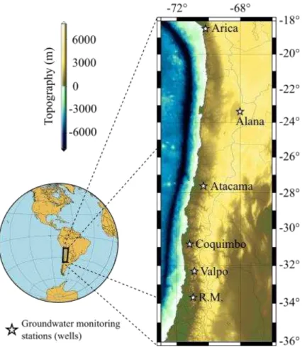
Figure 1: Study region and well stations.
where refers to the number of subareas or zones divided in the study region; are the specific
yield values of the unconfined aquifers; are the sizes of subareas; and refer to the mean
values of the well or GRACE/GLDAS water-level variations in each subarea. The areas of influence related to each station ( ) were obtained by the Thiessen polygons algorithm (e.g., Raghunath, 2006).
2.4 Empirical Orthogonal Functions (EOF)
In order to identify and quantify the predominant spatio-temporal signal patterns in groundwater, an analysis by Empirical Ortogonal Functions (EOF) was performed in the study region. Other studies (see, e.g., Winter et al., 2000) had indicated that EOF analysis would be particularly useful for long-term groundwater monitoring, which would greatly reduce the cost of monitoring programs. In short, EOF analysis uses a set of orthogonal functions (i.e., EOFs) for representing a time series as:
where is the original time series as a function of time ( ) and space ( ) of the major factors that account for the temporal variations of while the principal components PC shows how the amplitudes of each EOF varies with time. To address some limitations of classical EOF analysis, such as the difficulty of physical interpretability, it is recommended rotating the EOFs (Hannachi, 2004). Thus, in this study we have applied the rotated EOFs (i.e., REOFs).
2.5 Groundwater anomalies from GRACE and GLDAS
Mass changes detected by GRACE (ΔMGRACE) are related to changes of hydrological mass
where is the precipitation, is the evaporation (describing all process of vaporization), is the lateral transport of water (generally equivalent to discharge), and are the first and last days of the month, respectively. In case that the region under investigation does not contain any major surface water bodies, as in Northern Chile, (4) can be simplified as follow:
The term ΔMGRACE is the residual variation of the hydrological mass, obtained as the difference of mean spherical harmonic coefficients with respect to the monthly fields at each epoch (Ramillien et al., 2005). Based on the methodology proposed by Wahr, et al. (1998), it can be expressed as:
where ΔClm and ΔSlm are the residual of the spherical harmonic coefficients (i.e., the mean value over the time period has been subtracted from the monthly values). ρEarth is the average density of the Earth, ρwater is the density of fresh water, a is the equatorial radius of the Earth, are the associated Legendre completely normalized functions of degree l and order m, kl is the Love number of degree l, θ is the spherical co-latitude, and λ is the longitude.
Terrestrial water storage anomalies derived from GRACE measurements were filtered by a destriping filter proposed by Swenson and Wahr (2006), which is based on a polynomial spline for consecutive coefficients, which can be odd or even, for a particular degree. The correlation between the coefficients is represented by a polynomial fit, and is removed from every coefficient. In addition to this filter, a Gaussian filter of 350 km was used to remove the remaining errors at short wavelengths (Swenson and Wahr, 2006). The filters previously applied to GRACE data reduce noise and remove some correlated errors, but also cause loss of signal strength. In order to restore the geophysical signal, a scaling coefficient was applied on the equivalent water storage according to Landerer and Swenson (2012).
3. Results and Discussions
3.1 Comparison of groundwater estimations
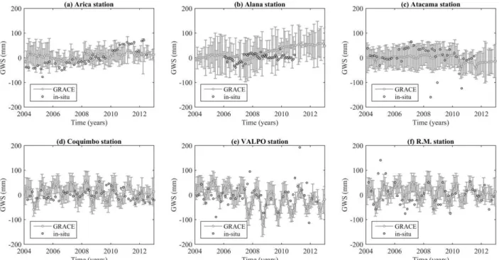
In order to have an overview and to contrast with GRACE/GLDAS estimations of GWS, from the metropolitan region to the north of Chile, a time series was constructed from 2004-2013 (Fig. 3) based on the six well stations data averaged through Eq. (2). It is possible to see the increase tendency of both time series. Moreover, in the period 2008.5-2013.0, both data sources are highly consistent, present trends of 1.5 mm/yr for GRACE and 2.9 mm/yr for well-based observation. Additionally, the amplitudes and patterns of both signals are quite different. GRACE-based GWS shows much larger water increases in the austral spring since 2004 until 2008, while it starts to show a water level decreasing until middle of 2012. This period of fall (2008-2012) is reported as period of drought that has blighted Chile since 2007. The drought in Chile, which began in 2007, has hampered copper production, exacerbated forest fires, and affected agriculture activities. During spring 2007 until winter of 2011, the well-based estimates and those from GRACE GWS show almost constant water level, which seems to be due to the drought episodes.
Figure 2: Time series of in-situ and GRACE-based groundwater storage changes obtained for
Arica (a), Alana (b), Atacama (c), Coquimbo (d), Valpo (e), and R.M. (f). The error bars represent the standard deviation among GRACE processing centers.
Additionally, this could also be due to the sparse temporal sampling of the ground measurements, and difference in spatial scales represented by the GRACE and GLDAS data.
Figure 3: Monthly groundwater storage anomalies for Northern Chile based on six wells and
GRACE/GLDAS data.
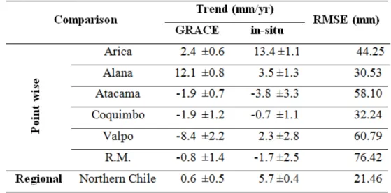
The trend estimates obtained from GRACE are quite consistent with well observations (Table 1). However, in some cases there are significant differences in terms of magnitude. These differences might be due to local effects not perceived by GRACE or errors such as sensor replacements at the DGA wells and gross errors as well (see Figure 2-c, the possible outliers between 2008 and 2011). Overall, the results of groundwater temporal variations from GRACE- and well-based observations in the study period reveal a mass gain of groundwater in Arica and Alana stations, and a loss in the Atacama, Coquimbo, and R.M. stations (Table 1). For instance, at Valpo station, the results obtained from GRACE and well observations show a positive and negative trend of 2.3 and -8.4 mm/yr for in-situ and GRACE-derived GWS, respectively. However, during the period from September 2008 to December 2012 a increase in the mass gain reaching ~11 mm/year is observed (Fig. 2-b). This effect reflected in this period could be due to a lack of rainfall and a high evaporation rate.
Table 1: Linear trend and its standard deviation (mm/yr)) of the time six stations’ series and we as for the averaged values as per Eq. (2) for GRACE-derived groundwater storage anomalies and
in-situ data.
3.2 EOF analysis of groundwater anomalies
In order to reveal patterns at regional scale and for a better physical interpretation of the spatio-temporal of GWS, Rotated EOF (REOF) were used (Fig. 4). A set of 104 monthly GWS grids with a spacing of 0.5° were used for the EOF analysis. Most of the signal variances of GWS are explained by the first three modes, which show annual and semi-annual patterns, these modes
account for 60.7% ( ), 13.9% ( ), and 11.2% ( ). The Principal Components
Figure 4: REOF1 60.7%, REOF 2 13.9%, REOF3 11.2% of the variance.
In relation to spatial variations (Fig. 4-d), the REOF1 (Fig. 4-a) corresponding to annual variations, these have the greatest negative variability in the Santiago Metropolitan Region, a slight positive variability in Arica, and slightly between Alana and Coquimbo. It is also possible to see that the center is located out of Chile (located at Bolivia and Argentina) and it seems that the patterns are influenced by the local factors such as orography. The REOF2 (Fig. 4-e) shows a significant positive variation from the north of R.M. On the other hand, REOF3 shows a negative variability in Valpo and Coquimbo regions (Fig. 4-f). However, with the center of EOF2 out of Chile while the center of EOF3 over Santiago Metropolitan Region.
4. Conclusions and Outlook
experienced in the metropolitan region, and decreases to the north. However, inter annual variations are seen from the metropolitan region to the north.
Differences between GRACE solutions and wells observations might be the result of deficiencies in GRACE and/or the GLDAS hydrological model that does not allow considering short term events. Nevertheless, our study shows that GRACE-based GWS estimations depicted the droughts episodes in the years of 2007, 2008, 2010, 2011, and 2012. Thus, the methodology used may contribute to regional study of temporal variations of groundwater in regions with sparse hydrometric network. As a future work, specific models and/or data that include soil moisture (e.g., Soil Moisture and Ocean Salinity – SMOS – satellite mission) in order to study the spatial distribution of recharge and discharge of major aquifers in northern Chile will be considered. Additionally, optical satellite imagery (e.g., Landsat 7, Landsat 8) will be analyzed with the aim to study vegetation growth and health as well as their correlations with groundwater changes.
ACKNOWLEDGMENTS
The authors, H. C. Montecino and G. Staub, would like to thank the University of Concepción for financial support through research project VRID 213.418.005-1.0. V. G. Ferreira acknowledges the support of grant No. 41204016 from the National Natural Science Foundation of China (NSFC). We also thank the science team from the three centers (CSR, GFZ, and JPL) for providing the monthly gravity field solutions. The GLDAS data used in this study were
acquired as part of the mission of NASA’s Earth Science Division and were archived and
distributed by the Goddard Earth Sciences (GES) Data and Information Services Center (DISC). In addition, the General Directorate of Water Resources (DGA) of Chile.
REFERENCES
Awange, J.L., Gebremichael, M., Forootan, E., Wakbulcho, G., Anyah, R., Ferreira, V.G., and Alemayehu, T. “Characterization of Ethiopian mega hydrogeological regimes using GRACE,
TRMM and GLDAS Datasets.”Advances in Water Resources 74 (2014): 64-78.
Banks, W.S., Paylor, R.L., and Hughes, W.B. “Using Thermal-Infrared Imagery to Delineate Ground-Water Discharge”. Ground Water, 34 (1996):443.
Becker, M. “Potential for satellite remote sensing of ground water.” Ground Water 44 (2006):
306-318.
Bettadpur S. UTCSR Level-2 processing standards document for Level-2 product release 0005, GRACE 327-742, Rev. 4.0. (2012).
Bobba, A., Bukata, R., and Jerome, J. “Digitally processed satellite data as a tool in detecting potential groundwater flow systems.” Journal of Hydrology 131 (1992): 25-62.
Boronina, A., and Ramillien, G. “Application of AVHRR imagery and GRACE measurements for calculation of actual evapotranspiration over the Quaternary aquifer (Lake Chad basin) and validation of groundwater models.”Journal of Hydrology 38 (2008): 98-109.
Brunner, P., Hendricks, H.-J., Kgotlhang, L., Bauer-Gottwein, P., and Kinzelbach, W. “How can
Cazenave, A., and Chen, J. “Time-variable gravity from space and present-day mass redistribution in the earth system.”Earth and Planetary Science Letters 298 (2010): 263-274. Chinnasamy, P., Hubbart, J., and Agoramoorthy, G. “Using remote sensing data to improve groundwater supply estimations in Gujarat, India.”Earth Interact. 17 (2013): 1-17.
Dahle, C., Flechtner, F., Gruber, C., König, D., König, R., Michalak, G., Neumayer, K. H., GFZ GRACE level-2 processing standards document for level-2 product release 0005. Deutsches GeoForschungsZentrum - GFZ (2013).
Ek, M. B., Mitchell, K. E., Lin, Y., Rogers, R., Grunmann, P., Koren, V., Gayno, G., and Tarpley, J. D. “Implementation of Noah land surface model advances in the National Centers for
Environmental Prediction operational mesoscale Eta model.” Journal of Geophysical Research:
Atmospheres 108 (2003): D22.
Fang, H., Beaudoing, H., Rodell, M., Teng, W., and Vollmer, B. E. “Global Land Data Assimilation System (GLDAS) products, services and application from NASA hydrology data
and information services center (HDISC).” Paper presented at the ASPRS 2009 Annual
Conference, Baltimore, Maryland, March 8-13, 2009.
Forootan, E., Rietbroek, R., Kusche, J., Sharifi, M., Awange, J., Schmidt, M., Omondi, P., and Famiglietti, J. “Separation of large scale water storage patterns over Iran using GRACE,
altimetry and hydrological data.”Remote Sensing of Environment 140 (2014): 580-595.
Frappart, F., Seyler, F., Papa, F., Martinez, J.-M., Le Toan, T., Santos da Silva, J., Prigent, C., Rossow, W. B. “Monitoring surface and groundwater variations using multisatellite observations
and hydrological modelling.”IAHS-AISH publication 343 (2011): 22-227.
Hannachi, A. A Primer for the EOF Analysis of Climate Data (UK: University of Reading 2004).
Accessed November 9, 2014. http://www.met.rdg.ac.uk/~han/Monitor/eofprimer.pdf
Heath, R. C. Basic ground-water hydrology (Reston, VA: U.S. Geological Survey 1983), Accessed April 15, 2015. http://pubs.er.usgs.gov/publication/wsp2220
Henry, C. M., Allen, D. M., and Huang, J. “Groundwater storage variability and annual recharge
using well-hydrograph and GRACE satellite data.”Hydrogeology Journal 19 (2011): 741-755.
Jackson, T. “Remote sensing of soil moisture: Implications for groundwater recharge.”
Hydrogeology Journal 10 (2002): 40-51.
Jha, M. K., Chowdhury, A., Chowdary, V. M., and Peiffer, S. “Groundwater management and development by integrated remote sensing and geographic information systems: Prospects and
constraints.”Water Resources Management 21 (2007): 427-467.
Jin, S., and Feng, G. “Large-scale variations of global groundwater from satellite gravimetry and
hydrological models, 2002–2012.”Global and Planetary Change 106 (2013): 20-30.
Joodaki, G., Wahr, J., and Swenson, S. “Estimating the human contribution to groundwater depletion in the middle east, from grace data, land surface models, and well observations.”Water Resources Research 50 (2014): 2679-2692.
Kolokoussis, P., Karathanassi, V., Rokos, D., Argialas, D., Karageorgis, A. P., and Georgopoulos, D. “Integrating thermal and hyperspectral remote sensing for the detection of coastal springs and submarine groundwater discharges.” International Journal of Remote Sensing 32 (2011): 8231-8251.
Information System - An interoperable framework for high resolution land surface modeling.”
Environmental Modeling and Software 21 (2006): 1402-1415.
Landerer, F. W., and Swenson, S. C. “Accuracy of scaled GRACE terrestrial water storage
estimates.”Water Resources Research 48 (2012): W04531.
Longuevergne, L., Wilson, C. R., Scanlon, B. R., and Crétaux, J. F. “GRACE water storage estimates for the Middle East and other regions with significant reservoir and lake storage.”
Hydrol. Earth Syst. Sci. Discuss. 9 (2012): 11131-11159.
McPhee, J., Fuente, A., Herrera, P., Niño, Y., Olivares, M., Sancha, A. M., Tamburrino, A., and Vargas, X. “El sector del agua en Chile: su estado y sus retos,” In Diagnóstico del Agua en las Américas, edited by Blanca Jiménez Cisneros and José Galizia Tundisi, 169-193. México: Foro Consultivo Científico y Tecnológico, AC 2012.
Meijerink, A. M. “Remote sensing applications to hydrology: groundwater.” Hydrological Sciences Journal 41 (1996): 549-561.
Meza, F. J. “Recent trends and ENSO influence on droughts in Northern Chile: An application of
the Standardized Precipitation Evapotranspiration Index.” Weather and Climate Extremes 1 (2013): 51-58.
Muskett, R. R., and Romanovsky, V. E. “Alaskan Permafrost Groundwater Storage Changes
Derived from GRACE and Ground Measurements.”Remote Sensing 3 (2011): 378-397.
Mutiti, S., Levy, J., Mutiti, C., and Gaturu, N. “Assessing Ground Water Development Potential
Using Landsat Imagery.”Ground Water 48 (2010): 295-305.
Peña, H., Luraschi, M., and Valenzuela, S. “Agua, desarrollo y políticas públicas: la experiencia de Chile.”REGA 1 (2004): 25-50.
Raghunath, H. M. Hydrology: Principles, Analysis and Design. New Delhi: New Age International, 2006.
Ramillien, G., Frappart, F., Cazenave, A., and Güntner, A. “Time variations of land water storage from an inversion of 2 years of GRACE geoids.” Earth and Planetary Science Letters
235 (2005): 283-301.
Ribera, A., and Lucero, R. O. “Las aguas subterrneas en Chile.”Boletín Geológico y Minero 117 (2006): 37-45.
Rodell, M., Houser, P. R., Jambor, U., Gottschalck, J., Mitchell, K., Meng, C. J., Arsenault, K., Cosgrove, B., Radakovich, J., Bosilovich, M., Entin, J. K., Walker, J. P., Lohmann, D., and Toll, D. “The Global Land Data Assimilation System.”Bull. Amer. Meteor. Soc. 85 (2004): 381–394. Rodell, M., Velicogna, I., and Famiglietti, J. “Satellite-based estimates of groundwater depletion in India.”Nature 460 (2009): 999-1002.
Scanlon, B. R., Longuevergne, L., and Long, D. “Ground referencing GRACE satellite estimates
of groundwater storage changes in the California Central Valley, USA.” Water Resources Research 48 (2012): W04520.
Squeo, F. A., Aravena, R., Aguirre, E., Pollastri, A., Jorquera, C., and Ehleringer, J.
“Groundwater dynamics in a coastal aquifer in north-central Chile: Implications for groundwater recharge in an arid ecosystem.”Journal of Arid Environments 67 (2006): 240-254.
Strassberg, G., Scanlon, B. R., and Chambers, D. “Evaluation of groundwater storage monitoring
with the GRACE satellite: Case study of the High Plains aquifer, central United States.” Water
Swenson, S., and Wahr, J. “Methods for inferring regional surface-mass anomalies from Gravity
Recovery and Climate Experiment (GRACE) measurements of time-variable gravity.”Journal of
Geophysical Research 107 (2002): 2193.
Swenson, S., and Wahr, J. “Post-processing removal of correlated errors in GRACE data.”
Geophysical Research Letters 33 (2006): L08402.
Tapley, B. D., Bettadpur, S., Ries, J. C., Thompson, P. F., and Watkins, M. M. “GRACE measurements of mass variability in the Earth system.”Science 305 (2004): 503–505.
Telford, W. M., Geldart, L. P., and Sheriff, R. E. Applied Geophysics. New York: Cambridge Univ. Press., 1990.
Travaglia, C., and Ammar, O. Groundwater exploration by satellite remote sensing in the Syrian Arab Republic. Rome: FAO Publications, 1998.
Tuinhof, A., Foster, S., Kemper, K., Garduno, H., and Nanni, M. “Groundwater monitoring
requirements for managing aquifer response and quality threats.” Technical Report, DC: World
Bank, 2004.
Wahr, J., Molenaar, M., and Bryan, F. “Time variability of the Earth’s gravity field: Hydrological and oceanic effects and their possible detection using GRACE.” Journal of Geophysical Research 103 (1998): 30205-30229.
Watkins, M. JPL Level-2 processing standards document for Level-2 product release 05, GRACE 327-741, Rev. 4.0. (2012).
Winter, T., Mallory, S., Allen, T., and Rosenberry, D. “The use of principal component analysis
for interpreting ground water hydrographs.”Ground Water 38 (2000): 234-246.
Xiao, R., He, X., Zhang, Y., Ferreira, V. G., and Chang, L. “Monitoring Groundwater Variations from Satellite Gravimetry and Hydrological Models: A Comparison with in-situ Measurements in the Mid-Atlantic Region of the United States”. Remote Sensing, 7(1) (2015): 686-703.
Recebido em Abril de 2015.