ABSTRACT: This study explores the potential deployment of small satellites for maritime interdiction and security applications by investigating the available solutions and formulating a generic proposal to optimize the use of those short-lived space assets in support of these operations. The operational background is analyzed with respect to the potential use of these systems by ield oficers. An analysis for operational micro and picosatellite characteristics is executed, and a brief outlook on the vulnerabilities of those for Low Earth Orbits is given. Moreover, a real scenario has been implemented, and the obtained computational results provide useful insight into how these space systems can be used for maritime security operations. Particular reference is given to the state-of-the-art status of propulsion systems capable of enhancing the lifetime of the satellites. Similarly, a literature survey has been conducted collecting all available picosatellites in orbit today that deal with maritime security applications. The study also explores the application of Lambdasat picosatellite (currently in orbit) to demonstrate the capability of exchanging alert messages between ground stations in Greece and in the US and vessels in the middle of the ocean. With these experiments we will demonstrate the ability magnitude of a picosatellite to support maritime operations.
KeywoRdS: Microsatellites, Picosatellites, Space maritime security operations, Micropropulsion, Vulnerabilities, Satellite communication, Picosatellite ground station.
Picosatellites for Maritime Security
Applications – the Lambdasat Case
Georgios Mantzouris1,3, Periklis Papadopoulos2, Nikitas Nikitakos3, Marco Manso4, Alex Bordetsky1,
Zacharias Sarris5, Garik Markarian3, Kyriakos Kourousis6,7
INTRODUCTION
The opeRATionAl MARiTiMe diMenSion
Contemporary maritime security operations cover a full range of diferent missions. As outlined in the European Union Maritime Security Strategy (Bordetsky and Netzer 2010), adopted in June 2014, they encompass protection of critical maritime infrastructure (e.g. ports and port facilities, of-shore installations, energy supply by the sea, and underwater pipelines), preservation of freedom of navigation (including security of crew and passengers against piracy) as well as prevention and countering cross-border illegal activities (such as human traicking and illegal transportation of dangerous materials and substances). In order to be efective, modern maritime security operations require a variety of diferent applications, multiple information sources and technological frameworks. In addition, a real-time infrastructure allowing to combine them into cost-effective intelligence schemes would dramatically decrease response time and, as a result, increase mission eiciency. However, such infrastructure is still absent from today’s operational and tactical maritime environment.
Maritime security missions cover a vast environment where satellites play an important role in exchanging information and contributing to the creation of shared situational awareness between force’s elements. Satellites can provide imagery and communications services, the latter also enabling bidirectional information exchange with civilian entities (e.g. commercial ships).
his paper is part of a work that explores the application of small satellites, also called PicoSats, CubeSats or picosatellites,
1.US Naval Postgraduate School – Center for Network Innovation and Experimentation – Graduate School of Operational & Information Sciences – Monterey/ CA – USA. 2.San Jose State University – Department of Aerospace Engineering – San Jose/CA – USA. 3.University of the Aegean – Department of Shipping Trade and Transport – Mytilene – Greece. 4.Rinicom Limited – Lancaster/LAN – UK. 5.Altus LSA Limited – Souda Bay – Crete – Greece. 6.University of Limerick – Department of Mechanical, Aeronautical and Biomedical Engineering – Limerick/MUN – Ireland. 7.RMIT University – School of Aerospace, Mechanical and Manufacturing Engineering – Melbourne/VIC – Australia.
Author for correspondence: Georgios Mantzouris | University of the Aegean – Department of Shipping Trade and Transport/US Naval Postgraduate School – Center for Network Innovation and Experimentation – Graduate School of Operational & Information Sciences | 589 Dyer Road, Room 225 | Monterey/CA 93943 – USA | Email: [email protected]
to assist security maritime operations, including surveillance, antipiracy as well as search and rescue operations. he interest in picosatellites is rising given their relative low cost (development and launch), relative ease of engineering, and available wide range of of-the-shelf equipment (Bordetsky and Dougan 2008).
In our work, we will conduct experiments that resort to the Lambdasat picosatellite, being the main objectives the global transmission and dissemination of information between ground stations and ships. We present our reasoning on the relevance of picosatellites for purposes of maritime security; then we describe the Lambdasat, a recently deployed picosatellites that we will use for our experiments on maritime security. We also describe our initial acquired data related with maritime experiments based on picosatellites, which includes message speciications and installations of the ground control station. hus we inalize by presenting the way ahead.
Historical background on the use of micro and minisatellites for maritime applications has been extensively given in, taking into account that, back in 1990s, the idea was very primitive and only very large space institutions had the capability to incorporate space into the maritime arena. Today very small satellites are accessible from universities and research organizations and, due to the miniaturization of the technology, more people has access to space. he use of space for maritime security is still an area where research is growing very fast, taking into account that 80% of Earth’s goods are being transferred via sea. herefore sea commerce and sea transportation is a major pilar of global market and that is why space maritime security is becoming more and more a ield at which research is being fast directed. Finally another important aspect that is being addressed in this paper is a detailed literature survey on the institutions that are conducting research initiatives in the areas of micropropulsion for very small to picosatellite buses. A micropropulsion thruster installed on board a picosatellite bus could raise the lifetime of it from one to two months to maybe six months up to ive years (rough estimation). Research is still ongoing in various organizations and is needed in order to prove what will be the exact number of the efectiveness of a microthruster on board a picosatellite. It has been veriied though and is under the main objectives of this research study that the most suitable microthruster for picosatellites is an electrothermal thruster for many diferent advantages that it encompasses. hat is why today there are very few universities to undergo this type of research aiming to ind a propulsion solution for these very cost-efective picobuses.
VulneRABiliTieS of piCoSATelliTeS in VeRy low eARTh oRBiTS
Before we start our analysis, we should mention that our Lambdasat picosatellite is orbiting in 380 to 420 km, directly below of the International Space Station. Due to orbital decay and ater approximately one year of orbital life, the satellite will be deorbited due to NASA requirements. In this altitude, though, there are some vulnerabilities that need to be addressed so the reader can understand the environment parameters. In summary the issues that need to be accounted in designing a microsatellite mission aiming to support maritime security operations with respect to altitude are:
• The effect of electrons and protons in Van Allen radiation belts on the survivability of satellites when they are passing through that zones.
• he identiication of the major risk areas inside Van Allen belts (especially in polar horns).
• he implications on satellite’s body from the atomic oxygen in North Pole (the aurora borealis).
• he efect of the atmospheric density near the mirror points of trapped particles on the satellite’s orbit.
• The effect of the 11 or 22-year solar cycle on the magnetosphere of Earth and as an atermath ionizing procedure in Low Earth Orbits (LEO).
• he vulnerabilities that a LEO satellite can withstand from ionizing particles coming from Earth’s ionosphere (e.g. how heavy ions in LEO afect satellites materials, such as aluminum, titanium, polymers etc.).
• he necessary material properties and dimensions (thicknesses) in accordance with Very Low Earth Orbit (VLEO) in order to avoid particle penetration procedures and inally charging of satellite.
• he efect of solar ultraviolet (UV) radiation into LEO through ionization of magnetosphere and the density of trapped particles.
• he efect of deep dielectric charging on a satellite (LEO antiproton radiation belt) (Gordon and Morgan 1993).
piCoSATelliTe opeRATionAl ChARACTeRiSTiCS
Services Satellites
1 2 4 8 16 24
Coverage 0.5 h 1 h 2.5 h 7 h 14 h 24/7
Video streaming X X X
Voice X X X
Telephone X X X X
Email exchange X X X X X X
Internet X X X
Real-time ship
tracking X X X X X X
Oriented missions X X X X X X
Land tracking X X X X X X
Photo streaming X X X X X X
Personal satellite X X X X X X Pricing (€) 100 K 200 K 400 K 800 K 1.6 M 2.4 M Table 1. Services via number of picosatellites that can be provided (pricing in approximate numbers).
To sum up though the operational part, one needs to have in mind the following attributes of the picosatellite system. he approximate total time that we have during a whole day to communicate through a system that has four satellites (the cost will be around 50000 € approximately) is 120 minutes (Universität Würzburg 2015) (two hours during the day). herefore the total gap time between consecutive satellites which passes during one day is approximately 22 hours (Universität Würzburg 2015). However, with this amount of timeframe, we have the capability to exchange the needed information with a merchant vessel underway and feed the important information required for a safe and secure transit from a high-risk area. Modern maritime threats, as they appear on the international scene today, do not require 24/7 hours of communication with fusion centers ashore, but only a logical timeframe suicient to transfer critical information back and forth and secure future courses of action. For example and taking into account information collected from open internet as well as oicial satellite companies sources for pricing and policy with subscribers, we can have the following case. If we have available 1,000,000 € and we charge 1$ per minute (best rate), it means 1,000,000 min/60 min per hour = 16,666.66 hours of selling time/24 hours per day = 694 days for returning the money back (this is only for telephone – worst case scenario) or 450 subscribers to pay 200 € per month = 90,000 € × 12 months = 1,080,000 € per year (a ship-owner pays approximately 10,000 € per month for one ship for satellite communication services).
We can easily see in Table 1 what a micro or picosatellite can provide to the customers taking into account how many satellites we have in orbit concurrently and how many hours they can cover. As one can see (and this is only an indicative scale table), the services are numerous and can extent to as many users as the bandwidth allows. A general rule is that a picosatellite can facilitate throughput up to 1.5 Mbps. Finally, in the last row of Table 1, pricing in approximate numbers is shown giving a rough indication of how much one or 12 picosatellites can cost to be in orbit (all inclusive).
On the other hand, Table 2 provides a generic/indicative representation of mini/femto satellite can alter its mass and cost as well as altitude and project lifetime in accordance with current technological trends and igures. Picosatellites (red coloured row) can stay up in orbit for up to two years (with no propulsion scheme) and the cost is 160 K$ per 1 kg (this is the maximum cost – a mean cost, as it has been referred previously, is up to 100 K$, all inclusive).
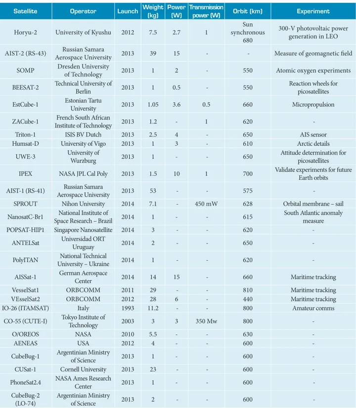
To date, all available picosatellites (with weight less than 1 kg) are listed in Table 3. Satellites that have weight greater than 1 kg are listed in this table for comparison purposes.
THE LAMBDASAT CONCEPT
he Lambdasat team formed in the Summer 2012 under the guidance and leadership of Professor Periklis Papadopoulos from San Jose State University, in California, and, with his strong ailiation with NASA Ames Research Center, initiated
Table 2. Generic representation of satellites with respect to cost and mass.
Mass (kg) Altitude (km) and orb period (h) project lifetime (years) Total cost (M$) Cost/mass (K$/kg)
Mini 100 – 500 1,000 – 5,000 (2 – 3 h) 4 – 7 10 – 150 200
Micro 10 – 100 500 – 2,000 (1.6 – 2 h) 2 – 5 1 – 30 400
nano 1 – 10 300 – 800 (1.4 – 1.7 h) 2 – 3 0.1 – 10 800
pico 0.1 – 1 200 - 400 (1.4 – 1.5 h) 1 – 2 0.05 – 2 160
Satellite operator launch weight (kg)
power (w)
Transmission
power (w) orbit (km) experiment
LO-19 (LUSAT) Amsat Argentina 1990 13.76 - -
Sun synchronous near polar LEO
CCD camera for Earth photography
FO-29 (JAS-2) Japan Aerospace
Agency 1996 50 10 1 Polar orbit 1,200
Sun sensor, geomagnetism sensor, magnetorquer, data processor and GaAs solar cells
RS-22 (Mozhayets 4)
Moscow Military
Academy 2003 64 - - 670
Glonass navigation and laser geodetic measurements
RS-40 (MiR) Siberian State
Aerospace University 2012 65 - - 1,500 LEO
AOCs for small satellites, Earth observation camera and others
CO-57 (XI-IV)
Intelligent Space Systems Lab – University of Tokyo
2003 1 8 800 mW 800 -
CO-58 (XI-V)
Intelligent Space Systems Lab – University of Tokyo
2005 1 8 800 mW 700 New types of solar cells
CO-65 (CUTE1.7+APDII)
Tokyo Institute of
Technology 2008 2 4 80 mW 630 Photodiode sensor module
COMPASS-1 University of Aachen 2008 0.85 1 - 600 GPS, Camera color images
CO-66 (SEEDS-II) Nihon University 2006 1 1.6 90 mW 620 -
RS-30 (Yubileiniy) Moscow Military
Academy 2008 45 - - - GPS, Glonass combination
PRISM (HITOMI)
Intelligent Space Systems Lab – University of Tokyo
2009 8.5 8 800 mW 660 Remote sensing
STARS
(KUKAI mother) Kagawa University 2009 4.2 8 3.8 666 Space tethered robotic satellite STARS
(KUKAI daught) Kagawa University 2009 3.8 8 3.8 666 Space tethered robotic satellite
KKS-1 (KISEKI)
Tokyo Metropolitan College of Industrial
Technology
2009 3 - - 636 Microthrusters and camera to Earth imaging
SwissCube-1 University of Lausanne 2009 < 1 1.5
-720 Sun synchronous near circular
polar
On-board telescope
ITU-pSat1 Istanbul Technical
University 2009 0.99 1 20 mW 723 On-board CMOS Camera
HO-68 (XW-1) China Amateurs 2009 50 21 200 mW 1,200 Sun
synchronous On-board CMOS Camera
TIsat-1
University of Applied Sciences of Southern
Switzerland
2010 < 1 - - 635 Atomic oxygen experiment
Jugnu Indian Institute of
Technology 2011 3 3.8 - 860 Microimaging and GPS
MaSat-1 (MO-72) BME Hungarian
University 2012 < 1 1.2
– 2.2 400 mW Circular 574
Table 3. continuation...
Satellite operator launch weight
(kg)
power (w)
Transmission
power (w) orbit (km) experiment
Horyu-2 University of Kyushu 2012 7.5 2.7 1
Sun synchronous
680
300-V photovoltaic power generation in LEO
AIST-2 (RS-43) Russian Samara
Aerospace University 2013 39 15 - - Measure of geomagnetic ield
SOMP Dresden University
of Technology 2013 1 2 - 550 Atomic oxygen experiments
BEESAT-2 Technical University of
Berlin 2013 1 0.5 - 550
Reaction wheels for picosatellites
EstCube-1 Estonian Tartu
University 2013 1.05 3.6 0.5 660 Micropropulsion
ZACube-1 French South African
Institute of Technology 2013 1.2 - 1 620
-Triton-1 ISIS BV Dutch 2013 2.5 4 - 650 AIS sensor
Humsat-D University of Vigo 2013 1 3 - 610 Arctic details
UWE-3 University of
Wurzburg 2013 1 - - 650
Attitude determination for picosatellites
IPEX NASA JPL Cal Poly 2013 1.5 10 1 700 Validate experiments for future Earth orbits
AIST-1 (RS-41) Russian Samara
Aerospace University 2013 53 - - 575
-SPROUT Nihon University 2014 7.1 - 450 mW 628 Orbital membrane – sail
NanosatC-Br1 National Institute of
Space Research – Brazil 2014 1 - - 615
South Atlantic anomaly measure
POPSAT-HIP1 Singapore Nanosatellite 2014 3 - - 620 -
ANTELSat Universidad ORT
Uruguay 2014 2 - - 650 -
PolyITAN National Technical
University – Ukraine 2014 1 - - 620 -
AISSat-1 German Aerospace
Center 2014 14 15 - 660 Maritime tracking
VesselSat1 ORBCOMM 2011 29 - - 810 Maritime tracking
VEsselSat2 ORBCOMM 2012 28 6 - 440 Maritime tracking
IO-26 (ITAMSAT) Italy 1993 11.2 - - 800 Amateur comms
CO-55 (CUTE-I) Tokyo Institute of
Technology 2003 3 3 350 Mw 800 -
O/OREOS NASA 2010 5.5 - - 630 -
AENEAS USA 2012 4 - - 600 -
CubeBug-1 Argentinian Ministry
of Science 2013 1 - - 600 -
CUSat-1 Cornell University 2013 23 - - 600 -
PhoneSat2.4 NASA Ames Research
Center 2013 1 - - 600
-CubeBug-2 (LO-74)
Argentinian Ministry
of Science 2013 2 - - 600
-this work in order to design and built a picosatellite under the name of the Greek letter “Lambda” (Λαμβδα), which historically comes from the “Λ” of Lakedemons from Sparti and the “L” letter from the Greek word “Ελληνες” (“Greeks”).
Figure1. Lambdasat components and ground station.
Lambdasat fully deployed in testbed (Courtesy of Lambda Team; Sølvhøj 2002)
Lambdasat picosatellite after passing the tests and being certiied by NASA Ames Research Center (Courtesy of Lambda Team; Sølvhøj 2002) Ground station allocation in the University of the Aegean for communication with Lambdasat. Autotracking of the satellite via assorted software is implemented. (Courtesy of the University of the Aegean)
global commons. An overview of the various components of the LambdaSat is provided in Fig. 1.
• Make publicly available that maritime security operations can be supported from microsatellites with low-cost applications and create a framework for merchant mariners to have a near real-time operational support during their transiting through high-risk areas.
• Promote interest in the teaching and research activities of the respective institutions.
• Deepen the understanding at each institution of the economic, space engineering as well as cultural and social engineering ethics.
• Promote faculty and institutional exchanges where feasible by inviting faculty and staf of the partner institutions to participate in a variety of teaching and/ or research activities and professional development in space systems ield area.
• Exchange information pertaining to developments in teaching, student development and research at each institution – and publish the results.
• Sustain the motto that “he real future is the ideas waiting to come true and enlighten the endeavors towards perfection”.
uniVeRSiTy of The AegeAn’S Role
University of the Aegean is the designer for space maritime security risk assessment methods and analysis through the satellite. Specifically the strategic and operational objectives of the satellite with respect to maritime security are as follows.
Strategic Objectives
• Evaluate the use of nano and picosatellites in maritime security.
• Provide deterrence for maritime terrorism in the global commons.
• Provide merchant mariners with low-cost near real-time operational support during their transiting through high-risk areas.
Operational Objectives
• Experiment automatic identification system (AIS) implementation in maritime security operations.
• Support counter piracy – armed robbery operations through various methods of communication to merchant mariners (text, audio, video etc.).
AiM
he aim of the picosatellite project was to:
• Evaluate the use of nano and picosatellites (in this case, via Lambdasat) in maritime security, supporting especially counter piracy operations, and generally provide deterrence for maritime terrorism in the global commons.
• Promote space innovation and boost space knowledge as well as new ideas to the Greek space technological arena. Besides to carry out joint research towards the design and launch of “LambdaSat”.
• Exchange general scientiic knowledge among partners.
• Enhance fruitful cooperation among relevant students of the aforementioned university departments, under Professor’s supervision and guidance.
• Create Merchant Marine Risk Assessment Indexes: methodologies to efectively counter piracy – armed robbery through space microassets (such as Lambdasat).
• Operational support to armed guards on board the merchant vessel on a near real-time frame.
• Conduct measure of efectiveness and performance studies and determine the way ahead.
• Conduct feasibility study and implement a cost-efective analysis for inserting picosatellites in the maritime security arena.
• Utilize a ground station in Greece (University of the Aegean).
• Conduct studies for measures of efectiveness (MOEs), measures of performances (MOP), and cost-beneit analysis (CBA) as well as risk assessment.
• Exchange data from the satellite ground stations to a merchant vessel transiting through the high-risk area.
• Measure the operational effectiveness to support counter piracy – armed robbery in the high-risk areas (postorbit).
• Measure risk assessment factors change with the use of picosatellite for merchant mariners transiting high-risk areas (postorbit).
he partners of the project (relevant to the scope of this paper) come from diferent organizations/universities as follows:
• San Jose State University (SJSU): Professor Periklis Papadopoulos – principal investigator.
• University of the Aegean (UOA): Professor Nikitas Nikitakos – Shipping – AIS – counter piracy.
lAMBdASAT SuCCeSSful lAunCh – offiCiAl AnnounCeMenT of nASA
For historical purposes it is here where we refer the milestones that Lambdasat mission managed to perform even in an era of major economic crisis.
We quote the official announcement of NASA for the successful launch of Lambdasat picosatellite. his endeavor was a tremendous milestone for the Hellenic annals since it is the irst mission ever built only by Greeks and launched from the International Space Station (Takao and Ono 2004).
nASA MiSSion JuSTifiCATion
NASA has supported the whole mission from the beginning and, with the sole support of Professor Periklis Papadopoulos (San Jose State University), the justiication was to “support merchant shipping in countering maritime piracy in oceanic as
well as in littoral sea environment. In parallel, provide merchant mariners with near real time cost efective information such as text, video, audio, images etc. in order to proactively counter the maritime piracy threat during transiting in high risk areas”. Under this statement, the whole mission started in Summer 2012, and the satellite was set in orbit from the International Space Station by the end of February 2015 (February 24th). A mission
statement was also produced in order for all to get acquainted with the expectations, and this is herein referred as follows.
piRACy BACKgRound (ThReAT)
As it has been seen in the last years, piracy is an ongoing phenomenon that has drawn global attention. he United Nations Contact Group of Somalia (UNCGPCS), the North Atlantic Treaty Organization (NATO) Operation Ocean Shield, the European Union mission EU NAVFOR Atalanta along with US, Chinese, Indian, and Iranian maritime forces (via patrolling vessels in the area of Gulf of Aden) have special interest in contributing to the diminishing of the phenomenon by safeguarding with military vessels the high-risk area. High-risk areas are considered to be Indian Ocean, Gulf of Aden, Gulf of Oman, West Africa oceanic area and broad area of Gulf of Mexico and the Central America. It is worth noting that, even if piracy is diminishing in the Indian Ocean, it is increasing in West Africa areas.
CuRRenT SiTuATion (weAKneSSeS)
he current status is that, if a piracy incident happens, the merchant mariners have only one way of communication with operational ashore headquarters, which is UKMTO or national authorities. his is conducted mainly via Inmarsat satellite service, which is a very costly mean of communication (1 min of communication costs around $ 100 or, for downloading 1 MB of data, it costs 80 €), or via VHF when near shoreline (up to 16 nm).
he most important aspect is that pirates are travelling throughout a vast oceanic area which is, in this case, Indian Ocean, Gulf of Aden, Gulf of Oman, and Bab El Mandeb straits, and the captain of the merchant vessel has not prominent or instant communication path in order to get informed on a regular basis (on a near real-time frame) for the new positions of incidents or pirates that are in the area.
team leader (guard) on board a merchant vessel will eventually know what is happening around their ship not in a range of 40 miles (range of conventional sensors like radars), but at longer distance and with a capability of knowing every 40 min what is happening in a circular range around the ship (positive identiication of up to 200 miles). his will give the capability to be proactive and not psychologically stressed for what is going to happen in the next hours of sail. he only information that they have now is only through TELEX from UKMTO, which is rare, and every 24 h.
In the last two years, NATO is seeking for cost-efective solutions to deal with the piracy problem in order to use as few ships as possible, patrolling the area of operations. here is a desire for moving into a cost-efective network-centric operational scheme in order to utilize patrolling assets only when necessary and not in a continuous basis. he continuous use of military vessels is costly for the nations, as well as not very efective since they have to be at sea for long times waiting to respond to an incident. By giving the capability for the merchant mariners to have updates every 40 min, they can act proactively and at the same time by using the satellite they can send us back to the real situational awareness data around their area of operation. herefore military vessels could be stationed on a littoral position ready to deploy their assets, when needed, only patrolling outside pirate camp areas and creating a type of unoicial embargo for their actions.
wAy AheAd (oppoRTuniTieS/STRengThS)
First and foremost, it is important to note that we try to inform a merchant vessel mariner on board a vessel in the middle of the ocean on a near real-time scheme (eventually every 40 min that the microsatellite Lambdasat will pass over the same area). his will give it the capability to have on-hand information on recent piracy incidents at least every 40 min and at very low cost.
Additionally, implementing a space AIS capability we deliver to the mariners another very helpful piece of critical information. he merchant mariners now have relevant AIS information which reaches distances of up to 20 – 30 nautical miles through an Earth signal. By providing the capability of receiving space AIS info in the middle of the ocean (in distances up to 200 nautical miles around them – potential footprint of the satellite), they have at least a primitive indication which are the non-suspect vessels during the next hours of transiting. AIS is a system that is required from International Maritime
Organization (IMO) for all vessels above 300 tonnes. So if the merchant mariner has received AIS information for a vessel (that means it is more than 300 tonnes), he knows directly that the vessel is not a pirate skif, dhow or generally a suspect boat. herefore he does not have to wait to have this veriication until he has a visual contact with the vessel (this is the case happening today).
NATO has a special interest on counter piracy operations, and it has been reported and noted in the last two years that, even though piracy is decreasing as a phenomenon in the Indian Ocean, it is being increased in other areas like West Africa with recent incidents up to 150 miles from shore. he support and escorting operations is a status in the Gulf of Aden and Somali Basin area and especially through the International Transit Corridor. Russia, China, India, and US are providing this kind of escort throughout the Indian Ocean, if asked and at the same time they consume a lot of money. It will be much more cost-efective if we have systems on board the merchant vessels that would receive information from a center shore, which would feed them with near real-time information in order for them to get prepared and more proactive. Of course this link could be used vice versa for situational awareness. Another aspect is that the merchant vessel has always live and fresh information for suspect vessels that now is being missed. Nobody has the capability of transferring back this information. With Lambdasat capability, the merchant mariner will send this information every 40 min back to the center from the middle of the ocean (either data up to 300 kb, or voice, video, images etc.). his system will also work in littoral transiting and passages and in territorial waters (less than 40 nm).
Last but not least, the use of a microcamera on board a microsatellite would give the opportunity to the center shore (e.g. SJSU Maritime Operational Center - MOC) to distinguish among large cargo ships and small skifs, dhows or other suspect vessels that are now invisible in the oceanic areas. With this capability, the pirates would be very diicult to hide and at the same time the merchant mariners would have a irst-hand response on pirate activities and a much more safe passage through the high-risk areas.
oVeRAll MiSSion oBJeCTiVeS
• Relay piracy incidents report to merchant mariners in a near real-time frame (every 40 min). Today it is rare, random and in the best case via TELEX every 24 h.
• AIS implementation will increase vigilance and alertness in distances up to Lambdasat footprint (tentatively 200 miles).
• Information to MOC from all merchant vessels (MVs) in the area and the capability of the MOC to collect critical information that today is being done only via Inmarsat phone by voice or by text emails.
• Diminish the cost of the communication to the necessary and not charge huge amounts of money only for 1 MB of data for merchant marines communication (Inmarsat case).
• Give NATO (and nations) the capability to decrease military vessels in the area not patrolling continuously the high seas, but being stationed in a dynamic waiting area where assets will be ready to assist upon request from MVs.
COMMUNICATION SCHEME – CHARACTERISTICS
Concept
UOA, in conjunction with other partners, will provide a real scenario, which is going to be executed during the light mission. he scenario is going to be built initially on a conceptual basis, SJSU will verify its compatibility with the satellite’s characteristics and then the whole scenario is going to be tested via STK sotware. he instructions to incorporate experiments to be tested during light time are as follows:
• Data will be send from SJSU to Lambda satellite and then to a merchant vessel. his data should be received via cell phone on board the merchant vessel (open sea/ coastline/port areas).
• Send and receive data from mobile ground station to the merchant vessel, acting as shore advisory team to the ship (command and control mobile center).
• Measure the overall effectiveness of network,
communication, latency times among end users, weather data inluence and other important factors. All these areas are going to be speciied in upcoming meetings to inalize the exact priorities.
• Include voice in transmission if possible (these two factors are extremely helpful and supportive to maritime security issues).
• If a camera is going to be incorporated, then a transfer of a satellite image to the ground station or to the vessel should be of great importance for maritime safety purposes. Analyze the operational use of images received from VLEO satellites (there is no camera on board the Lambdasat but this feature is going to be implemented in the next picosatellite mission).
• UOA ground station team will transmit a text-type document of maritime security critical factors to a merchant vessel underway. hese critical factors are going to be the major factors that inluence the survivability of the ship when transiting through the high-risk area. he document has been prepared from UOA and in accordance with the communication speciications from the SJSU.
• During the analysis and research, the following research items would consider:
a. Speciications of the communication equipment on board merchant vessel (UOA). his can happen only ater receiving the exact communication scheme for the satellite from the SJSU.
b. Ways (if needed) on how this communication/ sotware can be modiied (if needed) in order to transmit the available data to the merchant vessel or to the other ground stations in Greece (SJSU).
c. Available throughput/bandwidth of the Lambda satellite (SJSU).
d. Ground station in Greece should be mobile (small antenna and a computer-based system).
e. Incorporate an AIS approach to the satellite bus. An AIS sensor can be installed in the satellite to receive AIS signals from the ships. All ships with tonnage greater than 300 tonnes need to have installed on board an AIS transmitter to transmit their positions to a shore station (IMO regulation). ORBCOMM in the US has launched the first satellite with implementation of a satellite AIS sensor on board its satellite bus. Further research is needed if this is an option. UOA is going to implement this type of search and provide more information to the principal investigator, if asked.
blackberry-type). he message will be a text with tables, word document and some images.
g. Ability to communicate back and forth
with Lambdasat during one pass timeframe (approximately 8 min of satellite available time in each pass).
h. Available test schemes:
Basic: text – simple data containing information
for piracy activity up to 300 kB (e.g. latitude, longitude, time, colour and name of the pirate vessel etc.).
Intermediate: audio – capability to talk to
shore stations and convey by voice high-risk area picture and situational awareness. Provide the capability to the field officers (i.e. team leaders, guards on board vessels, captains) to communicate with operational headquarters at no extra or very low cost.
Advanced: AIS – receive and relay AIS signals
from and to other vessels (up to 200 miles) (Mantzouris et al. 2015).
Lambdasat Transmitter
he Lambdasat transmitter is based on a Stensat radio beacon, a small FM transmitter capable of generating AX.25 unnumbered information (UI) packets at 1,200 bps AFSK and 9,600 bps FSK. he 9,600 bps FSK signal is compatible with G3RUH modulation. Power level is adjustable from 0 to 1 W operating on a single 5-V supply. he speciications of the beacon are as follows:
• Bands available: 2 m, 70 cm.
• Radio Frequency (RF) output power 0 to 1 W
programmable.
• Operating voltage (Vdd) of 5.0 V.
• Operating current of 650 mA in transmission.
• 40 mA when idle.
• Serial interface rate of 38.4 Kbaud UART 8 bit, no parity, one stop bit.
• Dimensions: 1.75 × 3.10” × 1.00”/44.45 × 78.74 mm.
• Mass: approximately 50 g.
• Digital input signal speciications: high signal > 0.7 Vdd.
• Low signal < 0.3 Vdd; 10 uA.
• Digital output signal speciications: high signal > 2.0 V.
• Low signal < 0.4 V; 3 mA sink.
• Mounting holes: 0.125’’; 4 – 40 mounting hardware.
• Frequency ranges: SRB-51-01 at 420 – 450 MHz and SRB-51-02 at 144 – 148 MHz.
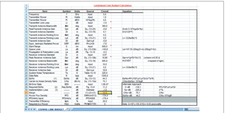
Lambdasat Link Budget – Communication
In order to set up the ground station, as well as to communicate with the satellite efectively, we analyzed and computed the link budget of it for the communication scheme. he central frequency that we are using is as indicated and above 437,462 MHz. Based on this frequency and taking into account orbital characteristics of the satellite, as well as losses through the medium and other parameters, we have calculated the link budget of Lambdasat in order to igure out how many decibels is the ratio of energy per bit rate for the noise igure. On the satellite a monopole antenna has been mounted, which has a length from 15 to 20 cm since there are three diferent very simple monopole antennas on two of the three dimensional axis of the satellite in the planes x and y. hese antennas serve to the purpose of communication with the ground station in the UOA.
As it is generally known link budget is a calculation that computes received power taking into account transmission power minus losses and plus all gains. his equation is as follows:
(1) Received power (dBw) =
transmission power (dBw) + gains (dB) − losses (dB)
Based on the above equation we have created a Microsot®
Excel spreadsheet that accumulates all the above factors containing each detail that is critical for our communication path. he calculation will show how much quantity of signal is going to be received on our ground station so as to inally decode the signal of the Lambdasat and receive AIS message as well as the piracy message.
approximately and for that reason we have played two dif erent scenarios with minimum and maximum slant ranges when the elevation of the satellite is more than 5 degrees, which practically gives us the capability to start communicating from the ground station in the UOA. In the i rst maximum case we have a margin of Eb over No 26 dB (100 times the signal stronger from the noise) whereas in the second minimum distance of slant range we have Eb/No 32 dB, which practically means that the signal is 1,000 times stronger from the noise. In both cases, though, we know that our i gures are acceptable for the communication of the Lambdasat with the ground station. Following our analysis and as known in the equations of link budget stemming from Schmidt (2015) and Lambdasat (2015), we have accumulated space losses as well as transmission line losses and system noise temperature. All these losses are being subtracted from the i nal collected energy level in order to give us the communication margin for the satellite. Ground station, as it will be analyzed next, comprises yagi UHF antennas of 42 elements with a gain that reaches 18 dB. Pointing losses of the antenna are less than 3 degrees since there is automatic control and tracking of the antenna that follows through automatic sot ware the change in azimuth and elevation of the satellite. Finally and for data rate of 1,200 bps, which is the data rate that our satellite is using in AFSK mode, we calculate using the Microsot ® Excel spreadsheets available that have been produced for this reason and
is shown in Fig. 2. h e i nal margin for communication with the satellite taking into account real-time orbital characteristics as well as worse and best-case scenarios is calculated to be in the range of 26 up to 32 dBW with only 1 W of available power.
PRELIMINARY ANALYSIS OF
ACQUIRED ORBITAL DATA
Experiments with Lambdasat and other micro and picosatellites were executed from March 2015 until August 2015. Via autotracking sot ware, available on the ground station of the UOA, a number of picosatellites have been acquired and their data, analyzed. h e commercial sot ware used for tracking two-line elements (TLE) of the satellite is Orbitron or GPredict (giving same results), and NORAD site was the primary provider of TLE sets for the orbit of the satellite on a daily basis.
h e i rst observation was that our satellite Lambdasat is having a Doppler dif erence of 8 to 10 kHz, when passing inbound and outbound respectively on a positive and negative ef ect. So, when approaching, the Doppler ef ect is +10kHz where in the outbound it is −10 kHz. h is situation is inl uencing the communication in a maximum degree since normal CubeSats and microsatellites like FO-29, Cubebag1, Funcube and others, as those we have downloaded
through our ground station, have a typical igure of 4 to 6 kHz. In accordance with the Doppler efect, function, and calculation, this is happening primarily due to the fact that the satellite is orbiting at a VLEO (lower than International Space Station) in 400 km, and the satellite velocity is 7.669 km/s (in accordance with calculations based on GPredict sotware and at March 11th). Date here is critical
since the satellite does not have on board propulsion, and an orbital decay parameter is afecting its motion.
First series of acquired data from Funcube picosatellite, via the UOA ground station, were collected in July 2015. Analysis of all the characteristics listed next is going to be made in order to conclude what is the amount of quality data that the Lambdasat or a picosatellite like Funcube can send in order to deine the space index metric for maritime security. If this space index be materialized (currently data is being collected from the ground station on a daily basis), then a measure of performance percent will be deined on how picosatellites can support the conduction of alert operations in maritime security arena. he elements of the data collection from the ground station for future analysis are:
• Time of pass of the picosatellite.
• Azimuth range.
• Elevation range.
• Altitude of light.
• Inclination.
• Duration of pass.
• Duration of received signal.
• Signal strength.
• Cloud coverage.
• Rain.
• Temperature.
• Actual message received.
• Number of quality bytes received.
Analyzing all the above data we manage to measure the efectiveness and performance of metrics that will be created for the use of picosatellites in alerted maritime security operations.
MICROPROPULSION IN PICOSATELLITES
Based on findings from previous paper (Mantzouris et al. 2015) with picosatellite Tubesat, further investigation on applying micropropulsion to microsatellite buses is necessary, in view of increasing their lifetime (e.g. from one month to one year). Based on a state-of-the-art review conducted for all available electric micropropulsion systems, possible candidates have been identiied in the range of few Watts providing thrust in the range of mN.
Currently, a few research institutes and universities have communicated results in this research ield. Table 4 and Fig. 2 present summarized indings of the state-of-the-art review, focusing on the performance characteristics of the various systems. he best available igure comes from the University of Kyoto (Japan), which has reported microwave electrothermal thruster power of 3.1 W capable of providing 4.3 mN thrust (Table 4). his igure can be considered to be applied on a micro and pico (but not femto) satellite bus and sustain orbital path for over a year. hus, the microwave electrothermal thrusters (MET) may be a viable solution for application in microsatellite buses.
E le ct ro st at ic L un ar M is sio n I o n JP
L L3 I
o n RF I o n RIT G ies sen LISA E le ct ro the rma l U sl an U ni ver si ty K o re a K yo to U ni ver si ty J ap an K yo to U ni ver si ty J ap an P enn S ta te X ia n U ni ver si ty C hin a AR CIE T R esi st o jet H o llo w c at h o de E le tr o mag ne ti c C u b es at S ur re y U ni ver si ty L as er A b la tio n P h o to nics RI AME M os co w JPL C u b es
at SSC S
ur re y O sa ka U ni ver si ty J ap an P ado va U ni ver si ty D u al s tage M icr o h o llo w di sc h ar ge Du al h all M icr o wa ve I o
n & H
al l P rin cet o n K eld ys h R es ea rc h M os co w Q u ad C o nfin em en t S ur re y O sa ka U ni ver si ty J ap an Pur d ue U ni ver si ty C u bs es at n an
o FEEP A
u st ri a U ni . F
eep 150 LISA Ho
k ka ido IT H o k ka ido IT K aug m ann I o n B razi l N at io n al I n st it u te P IO N 2 A er os p ace C o rp K yu sh u U ni ver si ty T o k yo U ni ver si ty 0 0.5 1 1.5 2 2.5 3 2.5 MET 0.225 0.32 0.5 0.25 All electric small satellites – thrust over power [mN/w]
Micro/nano/pico - MeT comparisons
power (w)
Thrust (mn)
Speciic impulse (s)
Thruster
eficiency (%) propellant
propellant low rate
frequency
(ghz) date institution
3 ↑ 1.8 – 5.6% - - Ar - 4
2011
Kyoto (NASA 2015)
6 ↑ 2.8 –12.3% - - Ar - 4
3 1.08 62 10 Ar 60 - magnet 4
3 1.03 59 9.2 Ar 60 - no magnet 4
6 1.23 70 6.8 Ar 60 - magnet 4
6 1.11 64 5.6 Ar 60 - no magnet 4
6 0.51 250 10.1 He 2 – 70 4
Kyoto (Lambdasat 2015)
6 0.51 375 10.1 H2 2 – 70 4
6 0.2 – 1.4 50 – 80 2 – 12 Ar + 5% N2
and H2 10 – 60 4 2009 Kyoto (Schmidt 2015)
6 1.4 80 8.7 Ar + 5% N2
and H2 60 2 and 4 2008
Kyoto
(Anderson and Sojka 2009)
With 4 GHz, plasma is little afected; with 10 GHz and shorter chamber, thrust performance is improved
2007
Kyoto
(Amateur Radio in Space 2015)
3 1.2 66 12 Ar - 4 Kyoto (Bordetsky and
Mantzouris 2011)
6 1.4 79 8.7 Ar - 4
6 1.4 80 8.7 Ar + 5%
N2 and H2 10 – 60 4 2008 Kyoto (Sølvhøj 2002)
10 2.5 – 3.5 130 – 180 - - 2 mg/s 1 – 25
2006 Kyoto (Wertz and Larson 2005)
5 1.1 73 4.2 Ar 10 – 50 4 Kyoto Abaimov et al. 2013)
4 2 136 12 Ar 1.5 mg/s 4 2005 Kyoto (Takao et al. 2008)
3.1 4.3 320 - Ar 280 4 2004 Kyoto (Seller 2004)
100 3 – 6 30 – 80 50 – 78 He, N2, and
ammonia 2 – 20 mg/s - 2004 Penn State Takahashi et al. 2007) 20 0.2 – 4.5 169 – 197 - He 2.15 mg/s 14.5 2007 Penn State (Takao and Ono 2004)
200 321 – 434 6.9 – 75 Ammonia
and hydrazine - 8 2001 Penn State (Takao et al. 2007)
100 – 250 15 – 90 190 – 315 - N2H3 - 8 2011 Penn State (Takahashi et al. 2009)
2.94 - - - He - 30 2011 Penn State (Kawanabe et al. 2011)
100 – 300 20 – 120 450 – 650 34 – 50 He 4.09 – 6.14 mg/s
-2008 Xian (Takao and Ono 2006a)
70 15 340 - He -
-120 25.5 × 10⁶ 5,758 61.3 N
2H4 4.4 mg/s - 2011 Xian (Takahashi et al. 2008)
1 – 5 2.5 – 3.5 130 – 180 - Xe and Ar 80 - 2011 Korea Ulsan University (Takao et al. 2011)
150 40 – 75 70 – 200 - He and N2O 0.025 mg/s 7.5 2004 Princeton (Takao and Ono 2006b) Table 4. Summarized data for various organizations that currently undergo research towards the microwave electrothermal propulsion areas.
Finally, one can see in Fig. 3 and through detailed analysis that the best available igure for a micropropulsion system is being delivered from a MET, which has the capability of delivering a thrust/ power ratio that reaches almost 1.5 (the exact igure is 1.38). his
↑ ↑
REFERENCES
Abaimov MD, Sinha S, Bilén SG, Micci MM (2013) CubeSat Microwave Electrothermal Thruster (CμMET). Proceedings of the 33rd International Electric Propulsion Conference. The George Washington University; Washington, USA.
Amateur Radio in Space (2015) Communication satellites; [accessed 2015 Nov 08]. http://www.amsat.org/amsat-new/satellites/ satInfo.php?satID=83&retURL=satellites/futures.php
Anderson P, Sojka J (2009) Development of a cubesat pico-satellite. Utah State University Undergraduate Research Showcase; Logan, USA.
Bordetsky A, Dougan A (2008) Networking and collaboration on maritime-sourced nuclear threats. Proceedings of 6th Security Workshop; Washington, USA.
Bordetsky A, Mantzouris G (2011) Modelling of pico satellite network applications to maritime interdiction operations. Proceedings of the 16th International Command & Control Research & Technology Symposium; Quebec, Canada.
Bordetsky A, Netzer D (2010) Testbed for tactical networking and collaboration. International C2 Journal 3(4):1-30.
Gordon GD, Morgan WL (1993) Principles of communication satellites. New Jersey: Wiley-Interscience.
Kawanabe T, Takahashi T, Takao Y, Eriguchi K, Ono K (2011) Microwave-excited microplasma thruster with applied magnetic ield. Proceedings of the 32nd International Electric Propulsion Conference; Wiesbaden, Germany.
Lambdasat (2015); [accessed 2015 Nov 08]. www.lambdasat.com
Mantzouris G, Papadopoulos P, Nikitakos N, Manso M, Markarian G (2015) Exploring the application of picosatellites for maritime security. Proceedings of the 20th International Command and Control Journal/ Conference; [accessed 2015 Nov 09]. http://www.dodccrp-test. org/s/067-s1wl.pdf
NASA (2015) Oficial NASA announcement for Lambdasat successful launch; [accessed 2015 Oct 10]. http://www.nasa.gov/mission_ pages/station/research/experiments/1865.html
Schmidt M (2015) Pico satellite activities of the University of Wuerzburg; [accessed 2015 Nov 08]. http://www.nanosat.jp/1st/ iles/10th.AM/Presentation_Marco-Schmidt.pdf
Seller JJ (2004) Understanding space: an introduction to Astronautics. 2nd ed. New York: McGraw-Hill.
CONCLUSION
his brief analysis aims to inform the reader in an alternative way to support maritime security operations. The micro and picosatellites are yet to prove their efectiveness in the operational theatre, though cost reduction is considered to be the driving force behind any advancement in this ield in the following years.
Sølvhøj J (2002) Onboard computer for picosatellite. Oersted: Technical University of Denmark.
Takahashi T, Takao Y, Eringuchi K, Ono K (2007) Numerical analysis and experiments of a microwave excited microplasma thruster. Proceedings of the 30th International Electric Propulsion Conference; Florence, Italy.
Takahashi T, Takao Y, Eriguchi K, Ono K (2008) Microwave excited microplasma thruster: a numerical and experimental study of the plasma generation and micronozzle low. J Phys Appl Phys 41(19):194005. doi: 10.1088/0022-3727/41/19/194005
Takahashi T, Takao Y, Eriguchi K, Ono K (2009) Numerical and experimental study of microwave-excited microplasma and micronozzle low for a microplasma thruster. Phys Plasmas 16(8): 083505. doi: 10.1063/1.3205889
Takahashi T, Takao Y, Ichida Y, Eriguchi K, Ono K (2011) Microwave-excited microplasma thruster with helium and hydrogen propellants. Phys Plasmas 18(6):063505. doi: 10.1063/1.3596539
Takao Y, Eriguchi K, Ono K (2007) A miniature electrothermal thruster using microwave–excited microplasmas: thrust measurement and its comparison with numerical analysis. J Appl Phys 101:123307. doi: 10.1063/1.2749336
Takao Y, Ono K (2004) Development and modeling of a microwave excited microplasma thruster. Proceedings of the 40th AIAA/ASME/SAE/ASEE Joint Propulsion Conference and Exhibit; Fort Lauderdale, USA.
Takao Y, Ono K (2006a) A miniature electrothermal thruster using microwave excited plasmas: a numerical design consideration. Plasma Sources Sci Technol 15(2):211-277. doi: 10.1088/0963-0252/15/2/006
Takao Y, Ono K (2006b) Performance testing of a miniature electrothermal thruster using microwave excited microplasmas. Proceedings of the 42nd AIAA/ASME/SAE/ASEE Joint Propulsion Conference and Exhibit; Sacramento, USA.
Takao Y, Takahashi T, Eriguchi K, Ono K (2008) Microplasma thruster for ultra small satellites: plasma chemical and aerodynamical aspects. Pure Appl Chem 80(9):2013-2023. doi: 10.1351/ pac200880092013
Universität Würzburg (2015) Pico satellite activities of the University of Wuerzburg; [accessed 2015 Nov 08]. www7.informatik.uni-wuerzburg.de
Wertz JR, Larson WJ (2005) Space mission analysis and design. 3rd ed. Portland: Microcosm.