Adv. Geosci., 35, 1–5, 2013 www.adv-geosci.net/35/1/2013/ doi:10.5194/adgeo-35-1-2013
© Author(s) 2013. CC Attribution 3.0 License.
Advances in
Geosciences
Geoscientiic
Geoscientiic
Geoscientiic
Geoscientiic
Construction of intensity-duration-frequency (IDF) curves for
precipitation with annual maxima data in Rwanda, Central Africa
G. R. Demar´ee and H. Van de Vyver
Royal Meteorological Institute of Belgium, Ringlaan 3, 1180 Brussels, Belgium Correspondence to:G. R. Demar´ee (gaston.demaree@meteo.be)
Received: 8 February 2013 – Revised: 8 May 2013 – Accepted: 14 May 2013 – Published: 25 June 2013
Abstract.Detailed probabilistic information on the intensity of precipitation in Central Africa is highly needed in order to cope with the risk analysis of natural hazards. In the moun-tainous areas of Rwanda land slides frequently occur and might cause a heavy toll in human lives. The establishment of Intensity-Duration-Frequency curves for precipitation in Central Africa remains a difficult task as adequate long-term data sets for short aggregation times are usually not available. In 1962 recording raingauges were installed at several sta-tions in Rwanda. According to the climatological procedures in use at that time in Congo, Rwanda and Burundi, maximum monthly and annual precipitation depths for fixed-time dura-tions of 15, 30, 45, 60 and 120 min were determined from the rainfall charts. The data set is completed by the monthly and annual daily precipitation extremes from the non-recording raingauge at the stations.
The authors used the dataset to establish the IDF-curves for precipitation at 3 stations in Rwanda having more than 20 yr of operation. The fixed-hour intervals of multiple 15 min require the use of a technique converting data from fixed-time intervals into data of arbitrary starting intervals. Therefore, the van Montfort technique was used.
1 Introduction
The purpose of this study is to establish Intensity-Duration-Frequency (IDF) curves for precipitation at 3 climatological stations in Rwanda. These stations are located in zones with a different rainfall regime. The IDF-curves for precipitation provide a mathematical expression linking the intensity, the duration or, better said, the aggregation time of the rainfall and the frequency of a rainfall event (Stedinger et al., 1993). The establishment of IDF-curves for precipitation is a
fre-quently used tool in water resources projects and manage-ment, sewer design in urban areas and geomorphologic re-search. In this case, a Montana-like formula is used as math-ematical expression of the IDF-curves relationship. This for-mula has proven its adaptability to express IDF-curves for precipitation under different rainfall regimes.
Only short-time Annual Maxima (AM) information was available for the sub-daily durations. In Sect. 2, the climate of Rwanda is briefly described and, in particular, the climato-logical aspects of the 3 stations are given. In Sect. 3, a Gum-bel probability distribution is fitted to the AM data. Further-more, the van Montfort technique is used to assess directly the parametersµAandσA of the Gumbel probability distri-butions for A-maxima of 15, 30, 60 min and 1-day.
2 Data and climate
The Republic of Rwanda, known as theLand of a Thousand Hills, is a landlocked country located in the Great Lakes re-gion of eastern-central Africa, bordered by Uganda, Burundi, the Democratic Republic of the Congo and Tanzania (Fig. 1). It covers an area of 26 338 km2. The country is bounded in the west by a mountain zone running south-north with an al-titude of between 2000 and 2500 m. To the east of this range, the plateaus are at an altitude of approximately 1500 and 2000 m. To the west of this range is situated Lake Kivu at 1460 m elevation. On the plateau the mean annual rainfall varies between 900 and 1200 mm while in the mountains it varies between 1200 and 1500 mm. In the Kagera plains in the east part of Rwanda, rainfall amounts less 900 mm show-ing a tendency to aridity (Bultot and Griffiths, 1971).
Rwanda.
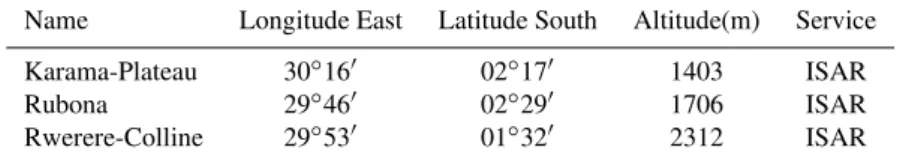
Name Longitude East Latitude South Altitude(m) Service Karama-Plateau 30◦16′ 02◦17′ 1403 ISAR Rubona 29◦46′ 02◦29′ 1706 ISAR Rwerere-Colline 29◦53′ 01◦32′ 2312 ISAR
Fig. 1.Map of the Republic of Rwanda with the location of the stations, Rwerere-Colline(a), Rubona(b)and Karama-Plateau(c).
Monthly and annual precipitation depths, expressed in 0.1 mm, for fixed-time durations of 15, 30, 45, 60 and 120 min were manually determined from the rainfall charts (Crabb´e, 1971). The rainfall charts are read in fixed-time calendar 15 min interval. The data set is completed by the monthly and annual daily precipitation extremes from the non-recording raingauge. The sub-daily maxima data from the recording raingauge showed excellent agreement with the daily maxima data from the non-recording raingauge at the same station. The recording raingauge network continued its operation till, more or less, the mid-eighties. Data used in the present research were extracted from the annual pub-licationsBulletin Climatologique Annuel mainly edited by ISAR. The AM extremes data set for the 3 stations above-mentioned were available to the authors for the years 1962 till 1985. The 3 stations selected on the basis of the length of their record are respectively: Karama-Plateau, Rubona and Rwerere-Colline (Fig. 1). Table 1 represents their geograph-ical characteristics. The length of the AM series is 20 yr for the stations Karama-Plateau and Rwerere-Colline and 23 yr
for the station of Rubona. These data are the core rainfall in-tensity data of the present study. Daily data are available for slightly longer to longer reference periods and therefore AM data for the daily maxima are included in the approach.
The station Karama-Plateau belongs to the Semi Arid Re-search Centre (SARC) of the Rwanda Agricultural ReRe-search Institute (ISAR) and is situated in the Eastern Province, dis-trict of Bugesera, at an altitude of 1403 m. The average annual precipitation is approximately 850 mm. The station Rubona-Colline is at an altitude of 1706 m. It received an average annual precipitation of 1240 mm over the reference period 1955–1990. The station Rwerere-Colline is part of the High Altitude Research Center (HARC) of ISAR. The station is located in the Northern Province, Rwerere sector, Burera district, at an altitude of 2312 m with an average annual rain-fall of 1200 mm.
3 Methodology
The Montana-type IDF-curve for precipitation was selected for the 3 stations:
iT ,d=
a(T )
(d+θ )η (1)
whered is the length of the precipitation andT is the return period of the event. The nominatora(T )is independent of the aggregation time so that the family of curves in T are parallel. The expression in the nominator is determined by the inverse function ofa(T )(Koutsoyiannis et al., 1998).
The denominator(d+θ )η of the Montana-type of IDF-curve provides the shape of the IDF-IDF-curves; the dynamical parametersθ andη describe the dynamics of the extreme rainfall process in function of the durationdand are climate-related.
As only annual maxima are available, the adequate prob-ability distribution functions are the 2-parameter Gumbel distributionGand the 3-parameter General Extreme Value (GEV) distribution. The cumulative distribution function of
Gis given by:
G(x;µ, σ )=exp
−exp
−x−µ σ
(2)
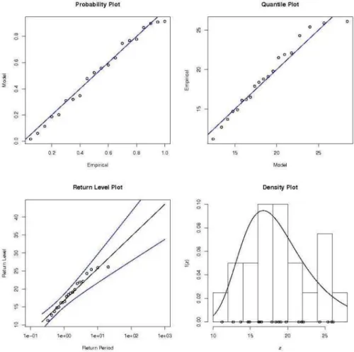
Fig. 2.Diagnostic plots for the Gumbel model fitted to the annual maxima of the 15-min precipitation data at Karama-Plateau (Coles, 2001).
location- and scale-parameter, respectively. To be more pre-cise, the location-parameterµspecifies the center of the dis-tribution; and the scale-parameterσ determines the size of deviations about the location parameter. It was shown that the 2-parameter Gumbel distributionGfitted the limited amount of data for the 3 stations by the model diagnostics plots de-veloped in Coles (2001). As illustration, the diagnostic plots for the Gumbel model fitted to the annual maxima of the 15-min precipitation data at Karama-Plateau are shown in Fig. 2 (Coles, 2001; ismev, 2013). The inverse function of the Gum-bel distributionG(x;µ, σ )is given by the following formula:
a(T )=µ−σln
−ln(1−1 T)
(3) Precipitation maxima of specific length with fixed starting points are often derived from digitizing rainfall charts. In this case the specific lengths are determined by the subdivision of the length of the hour on the graph. However, in quanti-tative hydrology, true maxima, this means maxima in time periods of specific length and with arbitrary starting point are required. In the following, the notation “A-maxima” is used for maxima precipitation amounts with an arbitrary
slid-ing startslid-ing point where “F-maxima” relate to fixed startslid-ing points. Van Montfort (1990, 1997) proposed a technique to convert maximum precipitation amounts in specific lengths with fixed starting points into maxima of the same specific length and sliding starting points.
The likelihood functionLis defined as:
L=
n
Y
i=1
g(xA,i;µA, σA) (4)
withxi≤xA,i≤x2i, where the indices A are indicative of
A-maxima,x1i andx2i are thei-th data points withi=1, ..., n
of the a given length and of its double length,gis the prob-ability density function of the Gumbel distribution G and which is approximated by the expression
g(xA,i;µA, σA)≈
G(x2i;µA, σA)−G(xi;µA, σA)
x2i−xi
(5) Practically it is more convenient to work with the log-likelihood function lnL. Optimizing lnLfor µA andσA is
equivalent to optimizing the equation below forµAandσA.
lnL=
n
X
i=1
T ,d for the stations Karama-Plateau, Rubona and Rwerere-Colline in Rwanda.
station µ(mm) σ (mm) θ(h) η
Karama-Plateau 40.48 7.86 0.25 0.94 Rubona 44.71 11.00 0.25 0.95 Rwerere-Colline 40.41 5.73 0.24 0.95
Table 3.Rainfall depths (mm) for return periodsT (year), and ag-gregation timesd(h) based on the adjusted IDF-curves of A-data at the station Rwerere-Colline (Rwanda).
T(year) 2 5 10 20 50
d=0.25 h 20.8 24.0 26.1 28.1 30.7
d=0.5 h 28.2 32.5 35.3 38.1 41.6
d=0.75 h 32.1 37.0 40.3 43.4 47.4
d=1 h 34.6 39.9 43.4 46.8 51.1
d=24 h 50.1 57.8 62.8 67.7 74.0
Table 4.Rainfall depths (mm) for return periodsT (year), and ag-gregation timesd(h) based on the adjusted IDF-curves of A-data at the station Karama-Plateau (Rwanda).
T (year) 2 5 10 20 50
d=0.25 h 20.9 25.2 28.1 30.8 34.3
d=0.5 h 28.5 34.4 38.3 42.0 46.8
d=0.75 h 32.6 39.3 43.8 48.0 53.6
d=1 h 35.3 42.5 47.3 51.9 57.9
d=24 h 52.2 63.0 70.1 76.9 85.7
Table 5.Rainfall depths (mm) for return periodsT (year), and ag-gregation timesd(h) based on the adjusted IDF-curves of A-data at the station Rubona (Rwanda).
T (year) 2 5 10 20 50
d=0.25 h 23.5 29.6 33.5 37.4 42.3
d=0.5 h 32.1 40.3 45.7 50.9 57.6
d=0.75 h 36.6 46.0 52.2 58.1 65.8
d=1 h 39.5 49.6 56.3 62.7 71.1
d=24 h 57.4 72.1 81.8 91.1 103.2
Then the parameters of the Gumbel probability distribution functionGfor arbitrary starting points are obtained by opti-mizing the log-likelihood function lnL.
The above-mentioned technique (van Montfort, 1990) is applied to the following couples of lengths (15–30) min-utes, (30–60) minmin-utes, (60–120) minmin-utes, and the (1-day, 2-days) precipitation data providing estimates of the parame-tersµAandσAof the Gumbel probability distributions for
A-maxima of 15, 30, 60 min and 1-day.
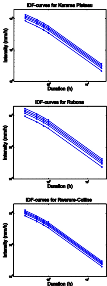
Fig. 3.Intensity-Duration-Frequency (IDF) curves for precipitation at the stations (from top to bottom) Karama-Plateau, Rubona and Rwerere-Colline, Rwanda, using A-type statistical parameters val-ues produced by the van Montfort technique.
Once the parameters of the Gumbel distribution functions are determined the quantiles of the Gumbel distributions are computed corresponding to return periods of 2, 5, 10, 20 and 50 yr. The parametersµ,σ, θ and η of the Montana-type formulaiT ,d are obtained by global optimization techniques
(Table 2).
4 Results
for return periodsT of 2, 5, 10, 20 and 50 yr are computed and are given in Tables 3, 4 and 5.
The 3 sets of IDF-curves for precipitation have approxi-mately the same dynamical parameters θ and η but show-ing differences in the magnitude of intensity; the order of magnitude of the intensity in the stations is (from low to high): Rwerere-Colline (Table 3), Karama-Plateau (Table 4) and Rubona (Table 5).
5 Discussion
Intensity-Duration-Frequency (IDF) curves for precipitation were obtained for 3 rainfall stations in different climate re-gions of Rwanda. Although that information is highly needed as natural hazards such as landslides are frequently observed in the country no such information was available until now for Rwanda. The numerical results obtained for the 3 sites in Rwanda are of similar magnitude to the results for Lubum-bashi, Congo (Van de Vyver and Demar´ee, 2010).
The information is based upon A-maxima of aggregation times with arbitrary starting points. That information was ob-tained by a van Montfort technique using F-data of aggrega-tion times with fixed starting points. The novelty in the paper is the use of a set of sub-daily precipitation F-data obtained from digitizing precipitation charts in combination with the data set of daily precipitation amounts.
Acknowledgements. The authors sincerely thank the Topical Editor and the Reviewers for their constructive remarks. The authors are grateful to the following libraries having provided the material of the data set: Royal Meteorological Institute of Belgium (RMIB), Universit´e de Li`ege (ULg), Gembloux Agro-Bio Tech (ULg), Royal Museum for Central Africa, African Library at Brussels, Michigan State University Libraries (Susan Graff), Science & Engineering Library Boston University (David Fristrom).
Edited by: K. Tokeshi
Reviewed by: two anonymous referees
References
Bultot, F. and Griffiths, J. F.: Rwanda and Burundi, World Survey of Climatology, Vol. 10, Climates of Africa, edited by: Landsberg, H. E., Elsevier Publishing Company, 349–368, 1971.
Coles, S.: An Introduction to Statistical Modeling of Extreme Val-ues, Springer Series in Statistics, London, 2001.
Crabb´e, M.: Recueil d’instructions relatives au r´eseau d’´ecoclimatologie (4e ´edition), R´epublique D´emocratique du Congo, Institut National pour l’Etude Agronomique du Congo (INEAC), Kinshasa, 1971.
ismev: An Introduction to Statistical Modeling of Extreme Values, CRAN – Package http://cran.r-project.org/web/packages/ismev/ index.html, last access: 23 April 2013.
Koutsoyiannis, D., Kozonis, D., and Manetas, A.: A mathematical framework for studying rainfall intensity-duration-frequency re-lationships, J. Hydrol., 206, 118–135, 1998.
Stedinger, J. R., Vogel, R. M., and Foufoula-Georgiou, E.: Fre-quency analysis of extreme events, in: Handbook of Hydrology, 18, edited by: Maidment, D. R., McGraw-Hill, 1993.
Van de Vyver, H. and Demar´ee, G. R.: Construction of Intensity-Duration-Frequency (IDF) curves for precipitation at Lubum-bashi, Congo, under the hypothesis of inadequate data, Hydrol. Sci. J., 55(4), 555–564, 2010.
van Montfort, M. A. J.: Sliding maxima, J. Hydrol., 118, 77–85, 1990.