www.the-cryosphere.net/10/2721/2016/ doi:10.5194/tc-10-2721-2016
© Author(s) 2016. CC Attribution 3.0 License.
Estimating the extent of Antarctic summer sea ice during the Heroic
Age of Antarctic Exploration
Tom Edinburgh1,aand Jonathan J. Day1
1Department of Meteorology, University of Reading, Reading, UK
acurrently at: Department of Applied Mathematics and Theoretical Physics, University of Cambridge, Cambridge, UK
Correspondence to:Jonathan J. Day ([email protected])
Received: 13 April 2016 – Published in The Cryosphere Discuss.: 29 April 2016
Revised: 11 September 2016 – Accepted: 18 September 2016 – Published: 21 November 2016
Abstract.In stark contrast to the sharp decline in Arctic sea ice, there has been a steady increase in ice extent around Antarctica during the last three decades, especially in the Weddell and Ross seas. In general, climate models do not to capture this trend and a lack of information about sea ice cov-erage in the pre-satellite period limits our ability to quantify the sensitivity of sea ice to climate change and robustly vali-date climate models. However, evidence of the presence and nature of sea ice was often recorded during early Antarctic exploration, though these sources have not previously been explored or exploited until now. We have analysed observa-tions of the summer sea ice edge from the ship logbooks of explorers such as Robert Falcon Scott, Ernest Shackleton and their contemporaries during theHeroic Age of Antarctic Ex-ploration (1897–1917), and in this study we compare these to satellite observations from the period 1989–2014, offering insight into the ice conditions of this period, from direct ob-servations, for the first time. This comparison shows that the summer sea ice edge was between 1.0 and 1.7◦further north
in the Weddell Sea during this period but that ice conditions were surprisingly comparable to the present day in other sec-tors.
1 Introduction
Understanding the interactions between polar sea ice trends and global climate change is of key importance in climate science. Amplified Arctic warming is closely associated with the dramatic reduction in Arctic summer sea ice, predom-inately through ice-albedo feedback effects (Manabe and Stouffer, 1980; Serreze and Barry, 2011). However the
rea-sons for the unexpected positive trend in Antarctic sea ice extent since the 1970s are not yet well understood (Parkin-son and Cavalieri, 2012; Turner and Overland, 2009), and the climate models submitted to the Fifth Climate Model Inter-comparison Project do not reproduce this circumpo-lar satellite-era increase (Maksym et al., 2012; Turner et al., 2013). This has led the Intergovernmental Panel on Cli-mate Change to assignlow confidenceto future projections of Antarctic sea ice extent in its latest assessment report (Stocker et al., 2013).
Figure 1.Map of expedition routes taken by ships used in this study. We only have coordinates for entry and departure of the pack ice for
the 1901–1903 Gauss Expedition (Indian Ocean).
al., 2013). A longer-term context may give some insight into our understanding of the dominant mechanisms.
Recent years have seen significant efforts in the recov-ery of historical meteorological records from ship logbooks (Brohan et al., 2009, 2010). Many of these logbooks contain detailed descriptions of the sea ice state at regular intervals and provide an invaluable source of sea ice edge information, but they require careful interpretation (Ayre et al., 2015). Such data are available from the earliest Antarctic voyages in the 19th century – of Cook, Bellingshausen, Ross and oth-ers (Wilkinson, 2014) – but data from this early period are too temporally and spatially restricted for any firm conclu-sions to be made (Parkinson, 1990). It is not until theHeroic Age of Antarctic Exploration that a sufficient level of data was collected to make concrete interpretations about the sea ice cover.
The period known as the Heroic Age of Antarctic Explo-ration began with the Belgian Antarctic Expedition of 1897– 1899 and ended in 1917 with the conclusion of Shackleton’s
British Imperial Trans-Antarctic Expedition. This period saw an expansion of exploration around the continent (Fig. 1), al-lowing perhaps the earliest window for pan-Antarctic climate analysis using observed records. It is worth noting that the difficulty in travelling through heavy pack ice, much more of a problem during this period than in the current day, undoubt-edly had a large influence on the expedition routes. For this reason, the sub-expedition voyages were undertaken mainly in the summer months (November–March), with some no-table multi-year exceptions (such as the Aurora and En-durance, during the 1914–1917 Imperial Trans-Antarctic Ex-pedition), during which ships drifted, frozen into the pack ice, throughout the Antarctic winter.
120
o
E 60
o E
Western Pacific Indian Ocean
75o
S
60oS
0
o
180
o
W
Ross Sea Weddell Sea
120 o W 60o
W
Bellingshausen and Amundsen
C
h
a
n
g
e
i
n
ic
e
ed
g
e
la
ti
tu
d
e
(
°
S
)
-8 -4 -1 -0.25 -0.1 0 0.1 0.25 1 4 8
Figure 2.Anomaly between ship-observed ice edge and the 1989–2014 mean PM Bootstrap algorithm derived ice edge position for the appropriate calendar day. Anomalies are plotted at logbook position.
dell Sea sector, where the century-long record of ice freeze and thaw dates at South Orkney Islands (Murphy et al., 2014) has enabled such proxies to be well calibrated, showing a long-term decline in both spring and autumn ice cover in this region (Abram et al., 2007). Nevertheless, it is currently un-clear how generalisable these methods are to other regions of Antarctica, due to a limited set of directly observed sea ice data (Abram et al., 2013). The results of the present work will provide additional reference points for such studies.
Twentieth century variations in sea ice cover have been in-ferred from whale catch positions, which provide a substan-tially more abundant, albeit less reliable and indirect, source of sea ice information (Vaughan, 2000). Previous studies, us-ing these catch positions as a proxy record for the ice edge, suggested a 2.8◦southward shift in the mean latitude of the
summer sea ice edge, equating to a 25 % decline sea ice ex-tent between 1931–1961 and 1971–1987 (Cotté and Guinet, 2007; de la Mare, 1997). However, there is some disagree-ment over the magnitude and spatial nature of results inferred
from these records (Ackley et al., 2003; de la Mare, 2009), in part due to the accuracy of the satellite-derived ice during the summer melt season (Worby and Comiso, 2004) but also due to the evolution of whaling practices in the Southern Ocean (Vaughan, 2000). However, the ice decline documented by de la Mare (1997, 2009) is consistent with a significant warming of the Southern Ocean between 1950 and 1978 documented recently by Fan et al. (2014). Whale catch records from ear-lier periods, in particular the Heroic Age, have not yet been used in sea ice analysis.
2 Method
We use data collected during 11 expeditions of the Heroic Age for which frequent observations on the composition and nature of the sea ice were recorded (Table 1). Many of these logbooks had already been digitised recently as part of the International Comprehensive Ocean-Atmosphere Data Set (ICOADS) initiative (Woodruff et al., 2011; Freeman et al., 2016). Others needed to be digitised specifically for this study, either from photographic images of the original log-book or in person from the original loglog-book itself. These were combined to create a dataset of 191 observed ice edge positions (included in the Supplement), providing an almost circumpolar picture of the Antarctic summer sea ice edge (Fig. 2).
Logbooks from this period typically include meteorologi-cal observations taken at frequent intervals throughout each day. Details of the sea ice cover were recorded along with a descriptive summary of the sea state and meteorology in the time period between the quantitative meteorological ob-servations. Sometimes sea ice remarks were recorded in a specific column of the logbook describing the ice state but more often included under a general observation heading that also encompassed additional comments regarding weather, sea state and other notable features, including wildlife. In some cases, the times of certain observations or events, such as when the ship passed from a region of consolidated ice cover into open water, were noted specifically. These obser-vations provide a clear picture of the presence and compo-sition of the ice throughout the expeditions. We have only used expeditions for which a summary of the sea ice condi-tions was recorded at frequent time intervals, discarding ex-peditions which only provide a daily summary for reasons of precision, and have included a full list of terms used to de-scribe the ice conditions in Table S1 in the Supplement. We have assumed that the times against which the observations were recorded reflect the time zone that the ship was operat-ing in. Whilst this was certainly the practice in Royal Navy logbooks of the time, it may not be true for all non-British expeditions (S. Woodruff, personal communication, 2015). Logbook times were all converted into UTC prior to compar-ison with the PM satellite data. In most logbooks, the posi-tion of each ship was recorded only at midday. Geo-locating remarks about the ice at other times of day required linear interpolation between the midday positions of consecutive days based on the time associated with the ice information.
In order to identify the sea ice edge for the period, we used these remarks about the sea ice to estimate points in space and time where the ships were traversing or travelling along the sea ice edge. The aim, and therefore the route, of an expedition had a significant impact on the number of ice edge points that can be determined for each particular log and there is a clear distinction in the type of exploration (see the videos in the Supplement).
Some expeditions, such as theTerra Novaexpeditions to the Ross Sea, were primarily concerned with land explo-ration or the race to the South Pole, and therefore the voyage of the ship was mostly a means of transport to the continent. In this scenario, it is common that the ship only crossed the ice edge on the journey south to and the return north from the continent – in which case, the positions of the first and last observations of sea ice on the respective journeys are taken as the ice edge. However, the focus of other expedi-tions, such as the Australasian 1911–1914 expedition to the Western Pacific sector, on theAurora, was to explore undoc-umented coastlines by ship. Hence, the ship was often trav-elling along the sea ice edge for long periods, passing in and out of areas of sea ice frequently, and the ice edge is often unambiguously recorded in the logbooks using terms such as “skirting pack ice”.
Interactions with the ice edge, in particular the navigation between open water and regions of ice cover, can sometimes be complicated by an ambiguity in the exact time that the ship encountered the ice edge. As an example, consecutive remarks in the log of theScotia expedition of 1903–1904, made on the 1 March at 11:00 UTC and 16 h later on the fol-lowing day at 05:00 UTC, observe “steaming through loose pack” and “no ice in sight” respectively. In cases such as this, this ambiguity makes it difficult to objectively identify the position of the ice edge, so we have taken the approach of trying to define a northern bound for the ice edge. We believe that a sensible approach is to utilise the entries recording the transition between these regions, using only the northernmost point within this pair of entries if the ship is travelling in a north–south axis and both entries if, as in the example above, the ship is travelling in an east–west axis. This approach in-creases our set of observations and reduces the level of sub-jectivity in the inference of the ice edge from the terms used in the logs.
Table 1.Expedition information and source materials used in this study. For items not digitised by ICOADS (Woodruff et al., 2011), the source material and archive are listed.
Date Ship Expedition Expedition Leader Sector Source
1897–1899 Belgica Belgian Antarctic Expedition Adrien de Gerlache Bellingshausen Arctowski (1904) and Amundsen
1901–1903 Gauss First German Antarctic Expedition Erich von Drygalski Indian Ocean Arctowski (1904)
1901–1904 Discovery National Antarctic Expedition 1901 Robert Falcon Scott Ross Sea Deck Logbook; Royal Geographical Society (AJP Collection)
item no.: AA/21/1 to AA/21/6 1902–1904 Scotia Scottish National Antarctic Expedition William Speirs Bruce Weddell Sea ICOADS; Mossman (1907) 1903–1904 Terra Nova National Antarctic Expedition 1901 Robert Falcon Scott Ross Sea Deck Log Book; Royal Geographical
Society (AJP Collection) 1907–1909 Nimrod British Antarctic Expedition 1907 Ernest Shackleton Ross Sea ICOADS; Kidson (1930) 1908–1910 Pourquoi-Pas? IV Fourth French Antarctic Expedition Jean-Baptiste Charcot Bellingshausen Rouch (1913)
and Amundsen
1910–1913 Terra Nova British Antarctic Expedition 1910 Robert Falcon Scott Ross Sea ICOADS
1911–1914 Aurora Australasian Antarctic Expedition Douglas Mawson Western Pacific ICOADS; Mawson (1939) 1914–1916 Aurora Imperial Trans-Antarctic Expedition Aeneas Mackintosh Ross Sea ICOADS
1914–1917 Endurance Imperial Trans-Antarctic Expedition Ernest Shackleton Weddell Sea ICOADS
addition, these bands often comprise mostly brash ice, the PM signature of which can be almost indistinguishable from seawater. They estimate the offset between the observed ice edge and ice edge derived using the Bootstrap algorithm to be 0.75±0.61◦ during the melt season. However, it should
be noted that their analysis has not been extended to other sectors, so we do not know how representative it is of the ice conditions outside of the Western Pacific, and also that the observers on-board ship during the Heroic Age were not trained sea ice observers. Nevertheless, it is important to take their findings into account in the following analysis, since an apparent southward shift in the ice edge between the Heroic Age points and the present-day Bootstrap-derived ice edge may overestimate the actual change and should therefore best be considered as an upper bound.
As there is greater consistency with the in situ ice edge observations, we have chosen to use the Bootstrap algorithm daily sea ice concentration from the National Snow and Ice Data Centre (NSIDC) to estimate the present-day sea ice edge, rather than NASA Team algorithm (Meier et al., 2013a; Peng et al., 2013). From this, we calculated a daily mean sea ice concentration for the period 1989–2014, during which daily data were available. Using this field, we have defined the daily satellite-observed mean ice edge as the contour joining the midpoints of the northernmost 25 km pixels that do not exceed a sea ice concentration of 15 %. Then, for each ice edge observation from the logbooks, we computed the distance from the ship-observed position to each point on the contour for that particular calendar day using the Haversine formula and spherical law of cosines and selected the lati-tude of the point on the contour with the minimum distance to the ship-observed position for the paired analysis. These differences were then averaged to calculate estimates for the mean change in the ice edge latitude for each sector and for the whole of Antarctica.
We believe the offset between the ice edge recorded by human observers and the satellite-derived ice edge to be the largest source of uncertainty in this analysis. Therefore, we use the Worby and Comiso value of 0.75◦in the discussion
of our results in order to address this source of uncertainty.
3 Results
The most dramatic change between the Heroic Age and the present day is in the Weddell Sea, where we have found that the ice edge was 1.71◦further north during the Heroic Age
and 0.96◦further north with the inclusion of the Worby and
Comiso offset, with both values significant at the 5 % level (Table 2). This change agrees well with the observed de-crease in land-fast ice at South Orkney Islands during the last century (Murphy et al., 2014).
However, observations in the Weddell Sea are clustered into a small number of years (1903, 1904 and 1914), and as such may be influenced by natural year-to-year variability in the sea ice extent. Indeed, the ice edge observed by the crew of theScotiain 1903 is particularly far north, even compared to observations from by the same crew the following year, and the greater ice extent in this region during the Heroic Age may be an exaggeration of the actual change between these two periods as a result. El Niño events often result in neg-ative surface air temperature and positive sea ice anomalies in the Weddell Sea (Yuan, 2004), and it is possible that the large El Niño of 1902–1903 may have had some influence on these anomalies. Nevertheless, our results indicate that many of the recorded ice edge positions lie further north than has been seen in any year since 1989 (Fig. 3, Supplement Fig. 2, Supplement video 1).
Table 2.Mean differences in ice edge latitude between the ship-observed and daily mean satellite-derived ice edge position by Antarctic sector. Positive differences indicate where the ship-observed ice edge is north of the mean satellite-derived ice edge. Bracketed quantities refer to the same difference, but with the Worby and Comiso offset subtracted.
Pan- Weddell Bellingshausen Ross Sea Western Pacific
Antarctic Sea Amundsen seas Sea and Indian Ocean
Mean difference 0.41 (−0.34) 1.71 (0.96) 0.21 (−0.54) 0.62 (−0.13) −0.08 (−0.83)
Variance of difference 1.44 3.76 0.25 1.97 0.47
Sample size 191 35 80 10 66
Wilcoxon signed-rank test
Approximatezvalue −4.41 (6.21) −4.17 (−2.85) −3.31 (6.66) −1.04 (0.74) 0.46 (6.73) pvalue < 0.001 (< 0.001) < 0.001 (0.022) < 0.001 (< 0.001) 0.099 (0.39) 0.33 (< 0.001) Significance significant significant significant significant (not) not (significant)
Latitude ship observations (S)
58 60 62 64 66 68 70 72 74
La
tit
ud
e
m
ea
n
sa
te
llit
e
(S
)
58 60 62 64 66 68 70 72 74
Weddell Sea 1902–1904
1914–1917 Bellingshausen and Amundsen
1897–1899
? IV 1908–1910 Ross Sea
1901–1904 1903–1904 1907–1909
1910–1913 1914–1916 Western Pacific 1911–1914 Indian Ocean
1901–1903 Scotia
Endurance
Pourqoui-Pas
Discovery Terra Nova Nimrod Terra Nova Aurora
Aurora
Gauss Belgica
Figure 3.Comparison of ship-observed and satellite-derived ice edge latitude, including a one-to-one line, which indicates no change in
position. The dashed line provides an estimate of the southward offset one would expect when comparing the satellite-derived ice edge to in situ ship observations, as calculated by Worby and Comiso (2004).
and 0.62◦the Ross Sea but no evidence of a significant
dif-ference in latitude in the Western Pacific and Indian Ocean region, which we have merged due to the limited data avail-able in the Indian Ocean sector (Tavail-able 2, Fig. 3). However, as
Year
1900 1920 1940 1960 1980 2000
Ex
te
nt
(1
0
6km 2)
0 2 4 6 8 10 12 14 16 18
HadISST.2.2.0.0 NASA Bootstrap NASA Team Heroic Age estimate With Worby and Comiso offset
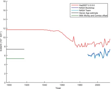
Figure 4.The estimated DJFM Antarctic sea ice extent climatology
for the period 1897–1917, with and without the inclusion of the Worby and Comiso offset, is plotted alongside time series of DJFM mean sea ice extent calculated from HadISST2.2, NASA Team and NASA PM Bootstrap sea ice concentration datasets.
By averaging over all points, we also find the mean cir-cumpolar change in the location of the ice edge. This pan-Antarctic shift of up to 0.41◦ southwards since the Heroic
Age implies at most a 14.2 % decrease in Antarctic sea ice extent between then and the present day (Fig. 4). This is much smaller than the 25 % decrease between the 1950s and 1980s that was inferred by de la Mare (1997) from whaling records and suggests that, if we accept the results inferred from the whaling records, the sea ice was less extensive dur-ing the period 1897–1917 than it was durdur-ing the period 1931– 1961.
Although ice edge latitude is a convenient measure in which to analyse the data, it is more common in climate change assessment reports, such as the IPCC-AR5, to assess hemispheric sea ice variability and change using sea ice ex-tent rather than ice edge latitude (Vaughan et al., 2013). We do not have estimates of the ice edge position for all longi-tudes and therefore cannot calculate the ice extent during the Heroic Age from the logbook data alone. However, we were able to form estimates using the shape of the satellite sea ice climatology for each day within the DJFM period, by com-puting the number of 25 km square grid cells within region enclosed by two contours: the 15 % ice concentration contour defined above and a contour radially shifted with respect to the calculated latitude change for that particular day. We then averaged this over the DJFM period and added the output to the mean NASA Bootstrap sea ice extent for the period 1989– 2016, to give a loosely approximated estimate of the ice ex-tent during the Heroic Age. This calculation also included regions enclosed by these two contours at polynya ice edges. We acknowledge the imprecision of these estimates that arise
from calculating this pan-Antarctic sea ice extent using only limited individual ice edge position data and suggest that fur-ther research could be done in this using an expanded dataset if possible.
Our estimate of the mean DJFM sea ice extent, based on the mean ice edge latitude, is 7.4×10⁶km2 (or
5.3×10⁶km2, using the Worby and Comiso offset).
Com-paring our DJFM sea ice extent estimate to the Met Of-fice Hadley Centre sea ice HadISST2.2 dataset (Titchner and Rayner, 2014), we find that our values are 4.3×10⁶km2
lower (Fig. 4). During this period HadISST2.2 is based on a climatology for the period 1929–1939, derived from Ger-man Atlas charts (GerGer-man Hydrographic Institute, 1950). Data from 185 whaling expeditions (mostly Norwegian but some from English whaling logbooks) were used as its basis (H. Titchner, personal communication, 2016).
4 Summary and discussion
In this study, we have used logbook data recorded by explor-ers during the Heroic Age of Antarctic Exploration to esti-mate an upper bound for the change between the summer sea ice edge during that period and the present day. The follow-ing summarises our conclusions:
– We estimate that the DJFM sea ice edge was at most 0.41◦further south between 1989 and 2014 than it was
during the Heroic Age (1897–1917), implying a reduc-tion of 14.2 % in pan-Antarctic extent.
– This change is most dramatic and statistically robust in the Weddell Sea, where the ice edge shifted by 1.71◦
southward between the two periods.
– Our estimate of the change in extent between the Heroic Age and the present day is small relative to estimates of the change between the 1950s and 1970s, based on whale catch data (Cotté and Guinet, 2007; de la Mare, 1997; Titchner and Rayner, 2014). This suggests the possibility that the sea ice was significantly more ex-tensive during the period 1931–1961 than during the Heroic Age.
Outside the Weddell Sea, the mean change in ice edge lati-tude is small compared to the known summer offset between in situ and satellite ice edges. It is therefore plausible that the sea ice extent in these regions has in fact experienced a small increase. Either way, the climate was much more sim-ilar to the present conditions than one might expect based on climate model simulations of the early 19th century (e.g. Turner et al., 2013). These ice edge data, which we make available in the Supplement of this paper, could be used by climate model developers as a tuning target for pre-industrial Antarctic sea ice cover.
changes (Ackley et al., 2003); this may be responsible for the disparity between our results and those investigating the whaling data. However, it is also plausible that the Antarc-tic ice edge exhibits significant decadal and multi-decadal variability (Latif et al., 2013), as has been observed in the Arctic (Day et al., 2012; Divine and Dick, 2006; Miles et al., 2014). If so, it is possible that there was an increase in sea ice extent between the Heroic Age and the 1930s, fol-lowed by the decrease between 1961 and 1971, suggested by de la Mare (1997). The MSA record from Law Dome, East Antarctica (Curran et al., 2003), and extensive sea ice in Nimbus satellite data from the early 1960s (Gagné et al., 2015; Meier et al., 2013b) seem to support this hypothesis.
We have excluded some of the expedition logbooks avail-able to us because of the lack of ice condition observa-tions, including the Southern Cross expedition of 1898– 1900, which only recorded a daily summary of the sea ice, and the Hertha andJason expeditions of 1893–1894, nei-ther of which recorded a summary of the sea ice. However, there are a few logbooks from this period, including those from the Norwegian expedition on the Fram (1910–1912), the Japanese expeditions on theKainan Maru(1910–1912) and the German expedition on theDeutschland(1911–1912), that have not yet been imaged and digitised and could poten-tially increase our knowledge of the sea ice conditions dur-ing this period. Similarly, although whaldur-ing records for the Heroic Age are less complete than during the later period studied by de la Mare (1997, 2009), whaling records from the Heroic Age could provide additional validation of our findings.
Further analysis into the processes driving the long-term variations in Antarctic sea ice described in this study will be an important next step. In particular, expanding our source of Southern Ocean climatological data by increasing efforts to digitise ship logbooks from this data-sparse region may be key to both our understanding recent Antarctic sea ice be-haviour and improving climate model performance.
5 Data availability
The ice edge points used in this study can be downloaded as as part of the Supplement associated with this paper. These were derived from the primary and secondary sources listed in Table 1, as described in Sect. 2.
These data were compared to satellite-derived sea ice con-centration data (Meier et al., 2013), which can be down-loaded from the NSIDC website.
The Supplement related to this article is available online at doi:10.5194/tc-10-2721-2016-supplement.
Acknowledgements. Tom Edinburgh was funded by a
NERC-SCENARIO-funded summer studentship. Jonathan Day was funded by an AXA Post-Doctoral Research Fellowship and a grant from the Walker Institute, University of Reading. We would like to thank Clive Wilkinson at the Climatic Research Unit, University of East Anglia, for his advice on logbook sources and for access to digitised logbook data, Holly Titchener (Met Office) and reviewers Dmitry Divine and Florence Fetterer for their useful comments and recommendations regarding the manuscript. Thanks also to the Royal Geographical Society Foyle Reading Room, for access to original logbooks from theDiscovery1901–1904 andTerra Nova
1903–1904 expeditions.
Edited by: C. Haas
Reviewed by: F. Fetterer and D. Divine
References
Abram, N. J., Mulvaney, R., Wolff, E. W., and Mudelsee, M.: Ice core records as sea ice proxies: An evaluation from the Wed-dell Sea region of Antarctica, J. Geophys. Res., 112, D15101, doi:10.1029/2006JD008139, 2007.
Abram, N. J., Wolff, E. W., and Curran, M. A. J.: A review of sea ice proxy information from polar ice cores, Quat. Sci. Rev., 79, 168–183, doi:10.1016/j.quascirev.2013.01.011, 2013.
Ackley, S., Wadhams, P., Comiso, J. C., and Worby, A. P.: Decadal decrease of Antarctic sea ice extent inferred from whaling records revisited on the basis of historical and mod-ern sea ice records, Polar Res., 22, 19–25, doi:10.1111/j.1751-8369.2003.tb00091.x, 2003.
Arctowski, H.: Les observations météorologiques de l’expédition du Gauss, Bull. Soc. Belge Astron., 9, 13–17, 1904.
Ayre, M., Nicholls, J., Ward, C., and Wheeler, D.: Ships’ logbooks from the Arctic in the pre-instrumental period, Geosci. Data J., 53–62, doi:10.1002/gdj3.27, 2015.
Bintanja, R., van Oldenborgh, G. J., Drijfhout, S. S., Wouters, B., and Katsman, C. A.: Important role for ocean warming and increased ice-shelf melt in Antarctic sea-ice expansion, Nat. Geosci., 6, 376–379, doi:10.1038/ngeo1767, 2013.
Brohan, P., Allan, R., Freeman, J. E., Waple, A. M., Wheeler, D., Wilkinson, C., and Woodruff, S.: Marine Observa-tions of Old Weather, B. Am. Meteor. Soc., 90, 219–230, doi:10.1175/2008BAMS2522.1, 2009.
Brohan, P., Ward, C., Willetts, G., Wilkinson, C., Allan, R., and Wheeler, D.: Arctic marine climate of the early nineteenth cen-tury, Clim. Past, 6, 315–324, doi:10.5194/cp-6-315-2010, 2010. Cavalieri, D. J., Gloersen, P., and Campbell, W. J.: Determination
of sea ice parameters with the Nimbus 7 SMMR, J. Geophys. Res.-Atmos., 89, 5355–5369, 1984.
Comiso, J. C.: Characteristics of Arctic winter sea ice from satellite multispectral microwave observations, J. Geophys. Res.-Ocean., 1978–2012, 91, 975–994, 1986.
Cotté, C. and Guinet, C.: Historical whaling records reveal major regional retreat of Antarctic sea ice, Deep Sea Res., 54, 243–252, doi:10.1016/j.dsr.2006.11.001, 2007.
Sea Ice Decline Since the 1950s, Science, 302, 1203–1206, doi:10.1126/science.1087888, 2003.
Day, J. J., Hargreaves, J. C., Annan, J. D., and Abe-Ouchi, A.: Sources of multi-decadal variability in Arctic sea ice extent, Env-iron. Res. Lett., 7, 034011, doi:10.1088/1748-9326/7/3/034011, 2012.
de la Mare, W. K.: Abrupt mid-twentieth-century decline in Antarc-tic sea-ice extent from whaling records, Nature, 389, 57–60, doi:10.1038/37956, 1997.
de la Mare, W. K.: Changes in Antarctic sea-ice extent from direct historical observations and whaling records, Clim. Change, 92, 461–493, doi:10.1007/s10584-008-9473-2, 2009.
Divine, D. V. and Dick, C.: Historical variability of sea ice edge po-sition in the Nordic Seas, J. Geophys. Res.-Ocean., 111, C01001, doi:10.1029/2004JC002851, 2006.
Fan, T., Deser, C., and Schneider, D. P.: Recent Antarctic sea ice trends in the context of Southern Ocean surface climate variations since 1950, Geophys. Res. Lett., 41, 2419–2426, doi:10.1002/2014GL059239, 2014.
Ferreira, D., Marshall, J., Bitz, C. M., Solomon, S., and Plumb, A.: Antarctic Ocean and Sea Ice Response to Ozone Deple-tion: A Two-Time-Scale Problem, J. Clim., 28, 1206–1226, doi:10.1175/JCLI-D-14-00313.1, 2015.
Freeman, E., Woodruff, S. D., Worley, S. J., Lubker, S. J., Kent, E. C., Angel, W. E., Berry, D. I., Brohan, P., Eastman, R., Gates, L., Gloeden, W., Ji, Z., Lawrimore, J., Rayner, N. A., Rosen-hagen, G., and Smith, S. R.: ICOADS Release 3.0: a major up-date to the historical marine climate record, Int. J. Climatol., doi:10.1002/joc.4775, 2016.
Gagné, M.-È., Gillett, N. P., and Fyfe, J. C.: Observed and simulated changes in Antarctic sea ice extent over the past 50 years, Geo-phys. Res. Lett., 42, 90–95, doi:10.1002/2014GL062231, 2015. Gille, S. T.: Warming of the Southern Ocean since the 1950s,
Sci-ence, 295, 1275–1277, 2002.
Holland, P. R. and Kwok, R.: Wind-driven trends in Antarctic sea-ice drift, Nat. Geosci., 5, 872–875, doi:10.1038/ngeo1627, 2012. Jacobs, S. S.: Freshening of the Ross Sea During the Late 20th Century, Science, 297, 386–389, doi:10.1126/science.1069574, 2002.
Kidson, E.: British Antarctic Expedition, 1907–1909, under the command of Sir E. H. Shackleton. Reports on the scientific in-vestigations, Meteorology, Government Printer, Melbourne, 118 pp., 1930.
Latif, M., Martin, T., and Park, W.: Southern Ocean Sector Centen-nial Climate Variability and Recent Decadal Trends, J. Clim., 26, 7767–7782, doi:10.1175/JCLI-D-12-00281.1, 2013.
Lefebvre, W., Goosse, H., Timmermann, R., and Fichefet, T.: Influ-ence of the Southern Annular Mode on the sea ice–ocean system, J. Geophys. Res., 109, C09005, doi:10.1029/2004JC002403, 2004.
Maksym, T., Stammerjohn, S., Ackley, S., and Massom, R.: Antarc-tic Sea Ice – A Polar Opposite?, Oceanography, 25, 140–151, doi:10.5670/oceanog.2012.88, 2012.
Manabe, S. and Stouffer, R. J.: Sensitivity of a global climate model to an increase of CO2concentration in the atmosphere, J. Geo-phys. Res.-Ocean., 85, 5529–5554, 1980.
Mawson, D.: Part 2: Meteorological Log of the S. Y. “Aurora”, in Australasian Antarctic Expedition 1911–14: Meteorology, Thomas Henry Tennant, Sydney, 110–208, 1939.
Meier, W., Fetterer, F., Savoie, M., Mallory, S., Duerr, R., and Stroeve, J.: NOAA/NSIDC Climate Data Record of Pas-sive Microwave Sea Ice Concentration, Version 2. Boul-der, Colorado USA: National Snow and Ice Data Center, doi:10.7265/N55M63M1, 2013a (updated 2015).
Meier, W. N., Gallaher, D., and Campbell, G. G.: New estimates of Arctic and Antarctic sea ice extent during September 1964 from recovered Nimbus I satellite imagery, The Cryosphere, 7, 699– 705, doi:10.5194/tc-7-699-2013, 2013b.
Miles, M. W., Divine, D. V., Furevik, T., Jansen, E., Moros, M., and Ogilvie, A. E. J.: A signal of persistent Atlantic multidecadal variability in Arctic sea ice, Geophys. Res. Lett., 41, 463–469, doi:10.1002/2013GL058084, 2014.
Mossman, R. C.: Meteorological Results of the Scottish National Antarctic Expedition, in Report of the scientific results of the voyage of S Y “Scotia,” vol. 2, Scottish Oceanographical Labo-ratory, Edinburgh, 1907.
Murphy, E. J., Clarke, A., Abram, N. J., and Turner, J.: Variability of sea-ice in the northern Weddell Sea during the 20th century, J. Geophys. Res. Ocean., doi:10.1002/2013JC009511, 2014. Parkinson, C. L.: Search for the Little Ice Age in Southern Ocean
sea-ice records, Ann. Glaciol., 14, 221–225, 1990.
Parkinson, C. L. and Cavalieri, D. J.: Antarctic sea ice vari-ability and trends, 1979–2010, The Cryosphere, 6, 871–880, doi:10.5194/tc-6-871-2012, 2012.
Peng, G., Meier, W. N., Scott, D. J., and Savoie, M. H.: A long-term and reproducible passive microwave sea ice concentration data record for climate studies and monitoring, Earth Syst. Sci. Data, 5, 311–318, doi:10.5194/essd-5-311-2013, 2013.
Polvani, L. M. and Smith, K. L.: Can natural variability ex-plain observed Antarctic sea ice trends? New modeling ev-idence from CMIP5, Geophys. Res. Lett., 40, 3195–3199, doi:10.1002/grl.50578, 2013.
Rouch, J.: Deuxieme Expedition Antarctique Francaise (1908–10): Oceanographie Physique, Masson et Cie., (imaged by NOAA), Paris, 1913.
Serreze, M. C. and Barry, R. G.: Processes and impacts of Arctic amplification: A research synthesis, Global Planet. Change, 77, 85–96, doi:10.1016/j.gloplacha.2011.03.004, 2011.
Sigmond, M. and Fyfe, J. C.: Has the ozone hole contributed to increased Antarctic sea ice extent?, Geophys. Res. Lett., 37, doi:10.1029/2010GL044301, 2010.
Stocker, T. F., Qin, D., Plattner, G. K., Tignor, M., Allen, S. K., Boschung, J., Nauels, A., Xia, Y., Bex, V., and Midgley, P. M.: IPCC 2013: Summary for Policymakers. In Climate Change 2013: The Physical Science Basis, Contrib. Work, Group Fifth Assess. Rep., Intergov. Panel Clim. Change, University Press Cambridge, UK, p. 25, 2013.
Swart, N. C. and Fyfe, J. C.: The influence of recent Antarctic ice sheet retreat on simulated sea ice area trends, Geophys. Res. Lett., 40, 4328–4332, doi:10.1002/grl.50820, 2013.
Thompson, D. W. J. and Solomon, S.: Interpretation of Recent Southern Hemisphere Climate Change, Science, 296, 895–899, doi:10.1126/science.1069270, 2002.
Turner, J. and Overland, J.: Contrasting climate change in the two polar regions, Polar Res., 28, 146–164, doi:10.1111/j.1751-8369.2009.00128.x, 2009.
Turner, J., Comiso, J. C., Marshall, G. J., Lachlan-Cope, T. A., Bracegirdle, T., Maksym, T., Meredith, M. P., Wang, Z., and Orr, A.: Non-annular atmospheric circulation change induced by stratospheric ozone depletion and its role in the recent increase of Antarctic sea ice extent, Geophys. Res. Lett., 36, L08502, doi:10.1029/2009GL037524, 2009.
Turner, J., Bracegirdle, T. J., Phillips, T., Marshall, G. J., and Hosk-ing, J. S.: An Initial Assessment of Antarctic Sea Ice Extent in the CMIP5 Models, J. Clim., 26, 1473–1484, doi:10.1175/JCLI-D-12-00068.1, 2013.
Turner, J., Hosking, J. S., Bracegirdle, T. J., Marshall, G. J. and Phillips, T.: Recent changes in Antarctic Sea Ice, Phi-los. Trans. R. Soc. Math. Phys. Eng. Sci., 373, 20140163, doi:10.1098/rsta.2014.0163, 2015.
Vaughan, D. G., Comiso, J. C., Allison, I., Carrasco, J., Kaser, G., Kwok, R., Mote, P., Murray, T., Paul, F., Ren, J., Rig-not, E., Solomina, O., Steffen, K., and Zhang, T.: Observations: cryosphere. In Climate Change 2013: The Physical Science Ba-sis, Clim. Change, 317–382, 2013.
Vaughan, S.: Can Antarctic sea-ice extent be deter-mined from whaling records?, Polar Rec., 36, 345–347, doi:10.1017/S0032247400016831, 2000.
Wilkinson, C.: Sources of Historic Sea-Ice Observations for the Southern Hemisphere, Recovery of Logbooks and International Marine Data RECLAIM Project – 2012 (revised and updated 2014), 2014.
Woodruff, S. D., Worley, S. J., Lubker, S. J., Ji, Z., Eric Freeman, J., Berry, D. I., Brohan, P., Kent, E. C., Reynolds, R. W., Smith, S. R., and Wilkinson, C.: ICOADS Release 2.5: extensions and enhancements to the surface marine meteorological archive, Int. J. Climatol., 31, 951–967, doi:10.1002/joc.2103, 2011.
Worby, A. P. and Comiso, J. C.: Studies of the Antarctic sea ice edge and ice extent from satellite and ship observations, Remote Sens. Environ., 92, 98–111, doi:10.1016/j.rse.2004.05.007, 2004. Yuan, X.: ENSO-related impacts on Antarctic sea ice: a
synthe-sis of phenomenon and mechanisms, Antarct. Sci., 16, 415–425, doi:10.1017/S0954102004002238, 2004.