ABSTRACT: The rainy season features for the Alcântara Launch Center region (2°S-3°S; 44°W-45°W), located at the northern coast of Brazil, were obtained by using the Climate Prediction Center/National Oceanic and Atmospheric Administration daily precipitation data from 1979 to 2012 accumulated to pentads. The rainy season onset (demise) was defined as the first pentad when precipitation is greater (lower) than the climatological annual average, and this behavior lasts for three out of the four following pentads. The average rainy season features were: 28 January as onset day; 16 June as demise day; 140 days as length; 1527 mm as total precipitation (about 80% of the annual value); and 10.9 mm day -1 as intensity (rain rate). The uncertainty on these climatological values due to the use of different precipitation datasets was estimated as few days for the onset/demise days and length, 100 mm for the total precipitation and about 1 mm day-1 for the intensity. Except for intensity, the rainy season features showed large interannual variability: standard variation of about one month for onset/demise days, and coefficient of variation of 33 and 40% for length and total precipitation, respectively. The three-week period between 24 March and 13 April belonged to the rainy season of all years. In general, longer (shorter) duration was related to early (late) onset, late (early) demise, and higher (lower) total precipitation. Within the rainy season, on an average, precipitation was lower than 0.1 mm day -1 in only four to five days; therefore, the occurrence of “no-rain” days was rather uncommon.
KEYWORDS: Aerospace meteorology, Precipitation, Climatology, Brazilian space program.
Rainy Season Features for the Alcântara
Launch Center
Urias Andrade Pinheiro1, Marcos Daisuke Oyama2
INTRODUCTION
he rainy season is usually deined as the period of the year when precipitation is higher (than a given threshold) due to atmospheric conditions that favor the occurrence of rain events. It is described by ive features: onset and demise days, length, total precipitation, and intensity (Table 1). Interannual variability of these features can severely afect socio-economic activities; for instance, in the semi-arid Northeast Brazil, people “anxiously await the annual arrival of the rainy season and its promise of an adequate harvest for that year; in the event of drought, [...] agricultural production is compromised and immense human sufering prevails” (Lemos et al., 2002, p. 479).
Here, we focus on the rainy season features for the Alcântara Launch Center [Centro de Lançamento de Alcântara (CLA)] region (2°S-3°S; 44°W-45°W; Fig. 1). It is a speciic region located at the northern coast of Brazil, and its importance is based on the fact that CLA is the main rocket launching center of the Brazilian space program. For the CLA region, climate is classiied as tropical humid (IBGE, 2002), annual precipitation is ~2000 mm, and the seasonal cycle shows maximum (minimum) precipitation in austral autumn (spring) (Pereira et al., 2002). his cycle is closely related to the seasonal latitudinal migration of the Atlantic Intertropical Convergence Zone (AITCZ): during austral autumn, AITCZ attains its southernmost position and directly afects the CLA region (Molion and Bernardo, 2002). Other atmospheric systems, such as coastal squall lines (CSL) (Cohen et al., 1995, 2009; Oliveira, 2012), easterly waves (Alves et al., 2008; Machado et al., 2009), and upper tropospheric cyclonic vortices (UTCV) (Kousky and Gan, 1981; Silva, 2005; Ferreira et al., 2009), also afect the precipitation amount (Barros
1.Instituto Nacional de Pesquisas Espaciais – São José dos Campos/SP – Brazil 2.Instituto de Aeronáutica e Espaço – São José dos Campos/SP – Brazil Author for correspondence: Marcos Daisuke Oyama | Praça Marechal Eduardo Gomes, 50 – Vila das Acácias | CEP 12.228-901 São José dos Campos/SP – Brazil |
Email: [email protected]
Figure 1. CPC-G precipitation data grid points. Central small circles indicate grid points for which precipitation data exist. The precipitation for the Alcântara Launch Center region is calculated as the average over the gray 1° x 1° box. Alcântara Launch Center position is indicated by the red circle.
EQ
1S
2S
3S
4S
5S
50W 49W 48W 47W 46W 45W 44W 43W 42W 41W 40W
Table 1. Deinition of the rainy season features; pk is the total precipitation (mm) in day k.
Rainy season feature Unit Symbol Deinition
Onset day Julian day Ti –
Demise day Julian day Tf –
Length Day L L = Tf - Ti + 1
Total precipitation mm P P = ∑ pk
Tf
k=Ti
Intensity
(or average rain rate) mm day
-1 I I = P/L
and Oyama, 2010). For the CLA region, interannual variability of precipitation is related to sea surface temperature anomalies (SSTA) in tropical Paciic and Atlantic oceans (Kayano and Andreoli, 2006; Marques and Fortes, 2012).
From the aerospace meteorology perspective (Vaughan and Johnson, 2013), knowledge about the rainy season features for the CLA region is particularly important and useful for the planning of rocket launching missions, since absence of rainfall (“no-rain” condition) is usually necessary for rocket-related activities in CLA (Marques and Fisch, 2005). Preliminary information about the rainy season climatology for the CLA region can be derived from the literature: the onset would take place from December to January; the demise, from May to June; and the length would be within the range of ive to seven months (Marengo et al., 2001; Liebmann et al., 2007; Silva et al., 2007). More precise information is not available, since the cited studies focused on larger scales (Amazonia or South America) and used diferent methods for rainy season identiication.
In this study, a detailed account on the rainy season features for the CLA region is given. he report is organized as follows. The precipitation dataset and the method to identify the rainy season onset and demise are described in the Data and Methodology section. he climatology and interannual variability of the rainy season features for the CLA region, their sensitivity to the use of diferent precipitation datasets, a discussion on the meteorological factors related to the rainy season onset, and a brief analysis on the dry days/spells within the rainy season are presented in the Results section. A summary of main indings of the study, as well as possibilities of future work, are given in the Concluding Remarks section.
DATA AND METHODOLOGY
PRECIPITATION DATA
Daily precipitation from the Climate Prediction Center (CPC)/National Oceanic and Atmospheric Administration (NOAA) dataset called “CPC Unified Gauge-Based Analysis of Global Daily Precipitation” (CPC-G), for the period from January 1979 to December 2012 (34 years), are used. The data are based on rain gauge measured precipitation and gridded on a 0.5° x 0.5° mesh using an optimal interpolation (OI) technique (Xie et al., 2007). Daily precipitation for the CLA region is calculated as the area-average precipitation over the four grid points that surround the CLA (Fig. 1). The daily data are accumulated to pentads for rainy season identification.
densities). Moreover, the OI technique led to a relatively stable performance statistics over regions covered by fewer gauges. This result is particularly suited for this study, as it minimizes the uncertainty related to the sudden drop in the number of gauges used for interpolation over the CLA region in the 2005–2012 period: the number of gauges within the CLA region varies from six to ten in the 1979–1988 period; from five to seven in the 1989–2004 period; and decreases to about two or three in the 2005–2012 period (see also Silva et al., 2007, p. 851).
RAINY SEASON IDENTIFICATION
In the literature, various methods to identify the rainy season features are found (the most common methods are briefly reviewed in Alves et al., 2005, p. 386). Here, we adopt a simple condition adapted from Gan et al. (2004), but based solely on pentad precipitation. The rainy season onset (demise) pentad is defined as the first pentad when precipitation is greater (lower) than the climatological annual average, and this behavior lasts for at least three out of the four following pentads. For a given year, the search for the onset pentad starts from pentad 63 (07–11 November) of the previous year and for the demise pentad, from pentad 20 (06–10 April) of the given year (this pentad is in the middle of the climatological rainy season, as will be shown in the next section). The onset (demise) day is defined as the middle day of the onset (demise) pentad, and the other features — length, total precipitation, and intensity — are calculated from expressions given in Table 1.
The identification of the onset pentad is illustrated in Fig. 2. From pentad −10 (which is the pentad 63 of the previous year) to pentad 5, precipitation is lower than the annual average. Pentads 6 and 8, albeit having above-average precipitation, are not the onset pentad, because in only two out of the following four pentads precipitation is greater than the annual average. The onset condition is firstly met by pentad 10.
RESULTS
RAINY SEASON FEATURES
he climatological rainy season features for the CLA region are shown in Table 2. On average, the rainy season extends from the end of January to mid-June, thus lasting for ~4½ months. Compared to the literature, the onset and demise days are within the range of December–January and May–June, respectively, but the length is slightly shorter than the range of ive to seven months (Marengo et al., 2001; Liebmann et al., 2007; Silva et al., 2007). he precipitation amount in the rainy season accounts for ~80% of the total annual average. he average intensity, of ~10 mm day -1, is quite high; its value is comparable to the annual
mean rain rate over the rainiest parts of Amazonia (Marengo and Nobre, 2009) and may be classiied as transition between light and heavy precipitation (Sun et al., 2006).
Except for the intensity, interannual variability of the rainy season features is large: standard deviation for the onset and
Figure 2. Illustration of the method to identify the rainy season onset. Light (dark) blue bars refer to positive (negative) pentad precipitation anomaly, that is, pentad precipitation greater (lower) than the climatological annual average. Negative pentads refer to pentads of the previous year: pentad p, p<0, refers to pentad p + 73 of the previous year. The black arrow points to the rainy season onset pentad.
P
en
tad p
re
ci
p
ita
ti
o
n a
no
ma
ly (mm)
Pentad
15
-6 -8
-10 -4 -2 0 2 4 16 8 10 12 14
10
5
0
-5
-10
-15
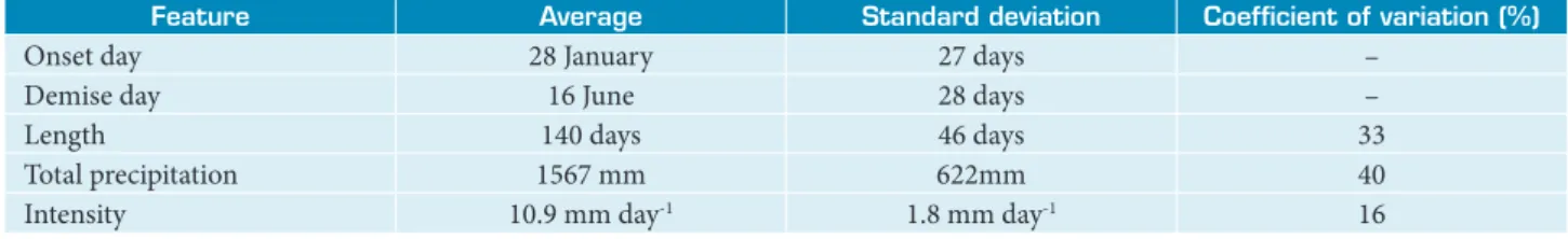
Table 2. Climatological rainy season features for the Alcântara Launch Center region (1979–2012).
Feature Average Standard deviation Coeficient of variation (%)
Onset day 28 January 27 days –
Demise day 16 June 28 days –
Length 140 days 46 days 33
Total precipitation 1567 mm 622mm 40
demise days is ~1 month; for the length, ~1½ month; and for the total precipitation, 40% of the average value. he smaller variability of the intensity — 16% of the climatological value — is related to the existence of a clear direct proportionality between total precipitation and length. he linear regression equation between these two features without the intercept term is (Fig. 3a):
P = 11.3 × L (1)
and the coeicient of determination value is very high (~90%). he slope term of Eq. 1, as expected, is close to climatological intensity value.
he temporal evolution of the rainy season from 1979 to 2012 is shown in Fig. 4. Marked changes from one year to the next (e.g., 1986–1988; 1993 and 1994) lead to the high value of standard deviation obtained previously for the onset/demise days and length, and illustrate the lack of lag-1 autocorrelation (almost zero) for these features. here are periods, however, when the rainy season length shows lower variability: for instance, from 1999 to 2004 (from 1979 to 1983, but 1982), the length is longer (shorter) than the average. he three-week period between 24 March and 13 April belongs to the rainy season of all years — this information could be useful for planning purposes. In general (~60% of the years), late (early) onset corresponds to early (late) demise, thus leading to shorter (longer) rainy season length. his behavior is ratiied by the linear regression analysis involving these features. Considering length as an independent variable, the equations for onset and demise anomalies are given respectively by (Fig. 3b–c):
∆Ti = –(0.49 × L – 69.0); (2)
∆Tf = 0.51 × L – 70.8 (3)
For both equations, the coeicient of determination value is ~70%, which indicates good itting skill.
Figure 3. Relation between rainy season length and total precipitation (a), onset day anomaly (b), and demise day anomaly (c). The linear regression line is drawn in blue color. The equation and the coeficient of determination (R2)
are shown. In (a), regression analysis is carried out without the intercept term.
3000
0 50 100 150 200 250
T o ta l p re ci p ita ti o n (mm) lenght (days) 2500 2000 1500 1000 500 0 y=11.344x R2=0.8789
Ons et d ay a no ma ly (d ay s)
0 50 100 150 200 250
lenght (days) 90 60 30 0 -30 -60 -90 y=-0.4934x+68.98 R2=0.7082
D emis e d ay a no ma ly (d ay s)
0 50 100 150 200 250
lenght (days) 90 60 30 0 -30 -60 -90 y=0.5066x-70.814 R2=0.719
(a)
(b)
(c)
Figure 4. Temporal evolution of the rainy season from 1979 to 2012. The horizontal bars represent the rainy season within each year. Dark (light) blue bars refer to the years when the anomalies of onset and demise days have opposite (the same) sign.
31-Dec
SENSITIVITY TO THE USE OF A DIFFERENT PRECIPITATION DATASET
he climatological rainy season features may be sensitive to the precipitation dataset used. To evaluate the degree of uncertainty related to this sensitivity, the rainy season features for the CLA region from 1997 to 2012 derived using daily precipitation data from a different dataset — the National Aeronautics and Space Administration (NASA) “Global Precipitation Climatology Project (GPCP) 1-Degree Daily Combination” (GPCP-1DD) (Huffman et al., 2001) — are compared to those derived using the CPC-G data. he GPCP-1DD dataset is a satellite-based spatial and temporal downscaling of the GPCP monthly precipitation estimate (outcome of merging microwave and infrared precipitation estimates and rain gauge data) on a regular 2.5° x 2.5° global mesh (Adler et al., 2003), and so does difer from the CPC-G dataset.
he average rainy season features for the 1997–2012 period derived from the two datasets show good overall agreement, as the bias values are low (Table 3). his implies the robustness of the climatological features obtained previously (cf. Table 2). he uncertainty may be estimated as few days (1–10 days) for the onset/demise days and length, 100 mm for the total precipitation, and ~1 mm day -1 for the average intensity.
The temporal evolution of the onset/demise days and length derived from both datasets are shown in Fig. 5 [the total precipitation and average intensity time series are not shown and are not analyzed because intensity is almost constant (coeicient of variation < 15%) and, consequently, total precipitation is closely proportional to length]. The overall agreement between the time series derived from the two datasets is excellent for the onset day (Pearson linear correlation coeicient, r ~ 0.9), and moderate for the demise day (r ~ 0.5) and length (r ~ 0.7). For the onset day, large diferences (~1 month) are found in three years (2006, 2008, and 2009), and the bias value results mostly from these speciic
diferences. For the demise day, systematic diferences are found until 2004, the largest absolute diferences (1–2 months) are found in three years (1999, 2010, and 2012), and the bias value results mostly from the systematic diferences (because the largest diferences do not have the same sign and partially cancel each other out). For the length, the time series pattern is similar to the demise day’s, and the diferences have smaller absolute value, although large diferences (>1 month) are still found in two years (1999 and 2010). herefore, the use of diferent precipitation datasets may lead to high uncertainty in the rainy season features for speciic years, but the average features would be only marginally afected by these temporally localized large diferences and, therefore, would be almost the same (i.e., low bias).
he rainy season features derived using the rain gauge data collected at the meteorological station in CLA (this dataset is hereater referred to as STN) (Marques and Fisch, 2005) are also compared to those derived using CPC-G and GPCP-1DD data. STN dataset should be regarded as the outcome of an independent station, because both CPC-G and GPCP-1DD datasets do not use STN data. he comparison is carried out for the short period from 2003 to 2012, when STN data are more reliable. For this period, the average rainy season features derived using STN data are close to those derived using CPC-G data and GPCP-1DD data (not shown). he temporal evolution of the rainy season features shows good overall agreement among the diferent datasets (Fig. 5).
• For the period 2005–2012, there is very good agreement. It adds reliability to the results derived using CPC-G data for this period, when uncertainty of CPC-G data are higher due to the small number of stations used for interpolation within the CLA region.
• he largest diferences (one to two months) are found in 2003 for the demise day and length. STN data show below-average precipitation during May 2003, and the
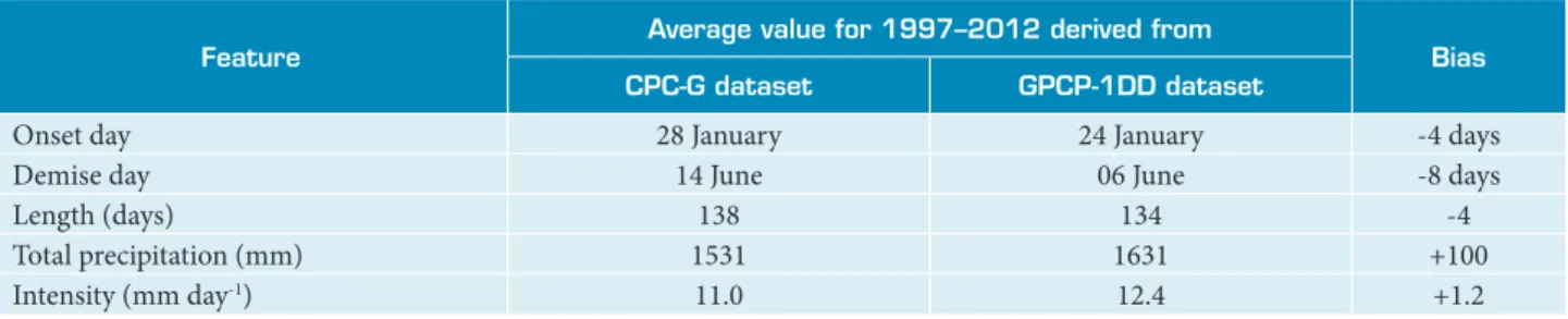
Table 3. Average rainy season features for 1997–2012 derived from CPC-G and GPCP-1DD precipitation datasets. Bias refers to GPCP-1DD minus CPC-G-derived values.
Feature
Average value for 1997–2012 derived from
Bias
CPC-G dataset GPCP-1DD dataset
Onset day 28 January 24 January -4 days
Demise day 14 June 06 June -8 days
Length (days) 138 134 -4
Total precipitation (mm) 1531 1631 +100
rainy season ends up prematurely, although above-average precipitation is found in the irst half of June. For CPC-G and GPCP-1DD data, the below-average precipitation period is much shorter and rainy season demise is postponed to mid-June (not shown). his kind of diference is expected when single station and interpolated data are compared (Silva et al., 2007).
DISCUSSION ON THE METEOROLOGICAL FACTORS
What are the meteorological factors that shape the high interannual variability of the rainy season features for the CLA region? For the 1979–2010 period, Pinheiro (2013) partially addressed this question by focusing on the rainy season onset. The conclusion was that early (late) onset would be mainly related to factors that favor (inhibit) precipitation occurrence over the CLA region: AITCZ located to the south (north) of the mean position and/or with high (low) intensity, negative (positive) SSTA in Nino 3.4 region [according to Trenberth, 1997, El-Niño (La-Niña) events refer to at least six consecutive months when the five-month running means of SSTA in Nino 3.4 region are positive (negative) with absolute value >0.4°C], and negative (positive) cross-equatorial SSTA gradient in tropical Atlantic. Other factors related to atmospheric systems that directly affect the CLA region, such as higher/ lower frequency of occurrence of UTCV and/or CSL, would be important to explain the onset day anomalies for specific years (Marques and Fortes, 2012). For instance:
• In 2001, the longest length in the 1997–2012 period for both CPC-G and GPCP-1DD datasets took place (Fig. 5). It resulted mainly from a pronounced early onset related to favorable conditions for precipitation occurrence over the CLA region in January 2001: more intense AITCZ located to the south of the mean position, La-Niña event in tropical Paciic, and negative cross-equatorial SSTA gradient in tropical Atlantic.
• In 1989, the onset day was the same as in 2001 (Fig. 4). Similarly to January 2001, there were a La-Niña event in tropical Paciic and negative cross-equatorial SST gradient in tropical Atlantic in January 1989; however, AITCZ position and intensity were close to the mean. he earliness was also related to higher frequency of occurrence of CSL over the northern coast of Brazil in January 1989.
• In 2010, the latest onset day in the 1997–2012 period for both CPC-G and GPCP-1DD datasets took place (Fig. 5).
he lateness was the result of unfavorable conditions for precipitation occurrence over CLA from mid-February to mid-March of 2010: weak (less intense) AITCZ located to the north of the mean position, El-Niño event in tropical Paciic, positive cross-equatorial SST gradient in tropical Atlantic, and high frequency of occurrence of UTCV over Northeast
Figure 5. Temporal evolution of the rainy season onset day (a), demise day (b), and length (c) derived from CPC-G (light blue), GPCP-1DD (dark blue), and STN (dotted) precipitation datasets.
30-Apr
31-Mar
1-Mar
30-Jan
31-Dec
1-Dec
1997 2000 2003 2006 2009 2012
Ons
et d
ay
CPC-G GPCP-1DD STN
(a)
12-Aug
13-Jul
13-Jun
14-May
14-Apr
15-Mar
1997 2000 2003 2006 2009 2012
D
emis
e d
ay
CPC-G GPCP-1DD STN
(b)
210
180
150
120
90
30 60
1997 2000 2003 2006 2009 2012
L
en
g
h
t (d
ay
s)
CPC-G GPCP-1DD STN
able to explain ~5% of the onset day variance; cross-equatorial SSTA gradient in tropical Atlantic, ~25%. hese fraction values are consistent with the results of Kayano and Andreoli (2006), who showed that interannual variations of the Northeast Brazil climate are more closely related to the tropical Atlantic variability modes than to the tropical Paciic’s. he role of SSTA in the Nino 3.4 region seems to increase for higher onset day variations: in more than half of the years in which the onset day occurs earlier (later) than the irst (third) quartile, the rainy season begins under negative (positive) SSTA in Nino 3.4 region. Future work is also needed to unravel the factors that inluence the rainy season demise.
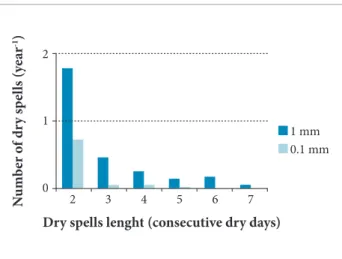
DRY DAYS AND DRY SPELLS WITHIN THE RAINY SEASON
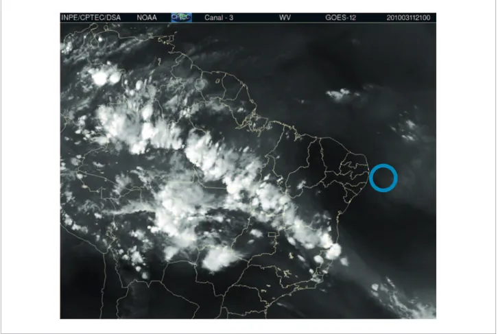
In the rainy season, as the atmospheric conditions are favorable to precipitation, the occurrence of dry days (days Brazil. An example of UTCV that inhibited cloud formation
over CLA in 11 March 2010 is shown in Fig. 6.
he analysis for speciic years, carried out by Pinheiro (2013), was useful to identify the factors related to rainy season onset, but further studies are needed to assess the relative importance of the factors statistically. Preliminary analysis indicates that AITCZ features (position and intensity), taken together, are able to explain ~20% of the onset day variance. his percentage seems to be consistent, because it is close to the average fraction of monthly precipitation variance explained by AITCZ features between January and February (Oyama and Carvalho, 2012). However, the percentage is rather low due to the diiculty in properly representing the magnitude of the onset day anomalies, even though the anomalies sign could be better predicted from the anomalies of the AITCZ features (proportion correct of about 75%). For the oceanic indices, SSTA in the Nino 3.4 region are
without precipitation or with small amounts of precipitation) or dry spells (consecutive dry days) would not be expected. But they do exist and their frequency could be regarded as an additional rainy season feature. Dry days are deined as those with precipitation lower than a given threshold. Here, two thresholds commonly found in the literature (e.g., Vicente-Serrano and Beguería-Portugués, 2003, p. 1107) — 1 and 0.1 mm day -1 — are used to identify the dry days within the
rainy season for the CLA region.
Considering the higher threshold (1 mm day -1), on
average, dry days account for about 11% (~15 days) of the rainy season. About half of the dry days are grouped in dry spells, and the amount of dry spells decreases sharply as its length (i.e., the number of consecutive dry days) increases (Fig. 7). he return period is longer than 1 year for dry spells lasting for three days or more. he results presented here are close to the values shown in INMET (2009) for a city near CLA (São Luís).
For aerospace meteorology purposes, the near-zero threshold (0.1 mm day -1) is important because it is more related to the
“no-rain” condition needed for rocket-related activities in CLA. Using this threshold, the amount of dry days/spells is much lower: on average, there are only four to ive dry days within the rainy season, and dry spells of any length have return periods longer than one year (Fig. 7). herefore, the “no-rain” condition is rather diicult to be met during the rainy season for the CLA region.
CONCLUDING REMARKS
he rainy season features — onset and demise days, length, total precipitation, and intensity — for the CLA region were obtained by using the CPC-G daily precipitation from 1979 to 2012 (34 years). For each year, the rainy season was identiied objectively from the pentad precipitation data derived from the daily’s. he main conclusions of this study were:
• he climatological rainy season features were: 28 January as onset day; 16 June as demise day; 140 days as length; 1527mm as total precipitation; and 10.9 mm d -1 as intensity.
• he uncertainty on these climatological values due to the use of diferent precipitation datasets (e.g., the GPCP-1DD and STN datasets) was estimated as few days for the onset/demise days and length; 100mm for the total precipitation and ~1 mm day -1 for the intensity.
• Except for the intensity, the rainy season features showed large interannual variability: standard variation of about one month for onset and demise days, and coeicient of variation of 33 and 40% for length and total precipitation, respectively.
• he three-week period between 24 March and 13 April belongs to the rainy season of all years.
• In general, longer (shorter) duration was related to early (late) onset, late (early) demise, and higher (lower) total precipitation.
• he occurrence of dry spells within the rainy season is rather uncommon; on average, in only four or ive days of the rainy season, precipitation is lower than 0.1 mm day -1.
he results presented here may be regarded as a irst step towards a comprehensive understanding of the rainy season for the CLA region. Follow-up steps could include studies on the meteorological factors/systems and oceanic indices that drive the anomalies of the rainy seasons features (e.g., by expanding the work of Pinheiro, 2013), as well as on the average atmospheric conditions related to the rainy season onset and demise (like Marengo et al., 2001; Barbieri, 2005).
ACKNOWLEDGMENTS
his work is part of the irst author’s MSc dissertation under the guidance of the second author. he authors are grateful to the three anonymous reviewers for their useful comments and suggestions.
Figure 7. Number of dry spells within the rainy season for the Alcântara Launch Center region per year as function of the dry spell length (i.e., the number of consecutive dry days) for two thresholds: 1 and 0.1 mm day-1.
2
N
um
b
er o
f dr
y s
p
el
ls (y
ea
r
-1)
Dry spells lenght (consecutive dry days) 1
0
2 3 4 5 6 7
REFERENCES
Adler, R.F., Huffman, G.J., Chang, A., Ferraro, R., Xie, P., Janowiak, J., Rudolf, B., Schneider, U., Curtis, S., Bolvin, D., Gruber, A., Susskind, J., Arkin, P. and Nelkin, E., 2003, “The Version 2 Global Precipitation Climatology Project (GPCP) monthly precipitation analysis (1979–present)”, Journal of Hydrometeorology, Vol. 4, No. 6, pp. 1147-1167.
Alves, L.M., Marengo, J.A., Camargo Júnior, H. and Castro, C., 2005, “Início da Estação Chuvosa na Região Sudeste do Brasil: Parte 1, Estudos Observacionais”, Revista Brasileira de Meteorologia, Vol. 20, No. 3, pp. 385-394.
Alves, M.A.S., Marques, R.F.C. and Oyama, M.D., 2008, “Detecção de Distúrbios Ondulatórios de Leste a partir de Filtros Temporais”, Proceedings of the XV Brazilian Congress of Meteorology, São Paulo, SP, Brazil.
Barbieri, P.R.B., 2005, “Characterization of the rain station in the south and southeastern regions of Brazil associated with the atmospheric circulation” (In Portuguese), MSc Dissertation, Instituto Nacional de Pesquisas Espaciais, São José dos Campos, SP, Brazil, p. 116.
Barros, S.S. and Oyama, M.D., 2010, “Sistemas Meteorológicos Associados à Ocorrência de Precipitação no Centro de Lançamento de Alcântara”, Revista Brasileira de Meteorologia, Vol. 25, No. 3, pp. 333-344.
Chen, M., Shi, W., Xie, P., Silva, V.B.S., Kousky, V.E.and Higgins, R.W., Janowiak, J.E., 2008, “Assessing objective techniques for gauge-based analyses of global daily precipitation”, Journal of Geophysical Research, Vol. 113, No. D04110.
Cohen, J.C.P., Silva Dias, M.A. and Nobre, C., 1995, “Environmental conditions associated with amazonian squall lines: a case study”, Monthly Weather Review, Vol. 123, No. 11, pp. 3163-3174.
Cohen, J., Cavalcanti, I.F.A., Braga, R.H.M. and Santos Neto, L., 2009, “Linhas de Instabilidade na Costa N-NE da América do Sul”, in: Cavalcanti, I.F.A.; Ferreira, N.J.; Silva, M.G.A.J. and Silva Dias, M.A.F. (Eds), “Tempo e Clima no Brasil”, Ed. Oficina de Textos, São Paulo, Brazil, pp. 75-93.
Ferreira, N.J., Ramirez, M.V. and Gan, M.A., 2009, “Vórtices Ciclônicos de Altos Níveis que Atuam na Vizinhança do Nordeste do Brasil”, in: Cavalcanti, I.F.A.; Ferreira, N.J.; Silva, M.G.A.J. and Silva Dias, M.A.F. (Eds), “Tempo e Clima no Brasil”, Ed. Oficina de Textos, São Paulo, Brazil, pp. 43-60.
Gan, M.A., Kousky, V.E. and Ropelewski, C.F., 2004, “The South America monsoon circulation and its relationship to rainfall over West-Central Brazil”, Journal of Climate, Vol. 17, No. 1, pp. 47-66.
Huffman, G.J., Adler, R.F., Morrissey, M., Bolvin, D.T., Curtis, S., Joyce, R., McGavock, B. and Susskind, J., 2001, “Global precipitation at one-degree daily resolution from multi-satellite observations”, Journal of Hydrometeorology, Vol. 2, No. 1, pp. 36-50.
IBGE, 2002, “Mapa Brasil Climas – Escala 1:5.000.000”, Retrieved in January 10, 2012, from ftp://geoftp.ibge.gov.br/ mapas_tematicos/mapas_murais/clima.pdf
INMET, 2009, “Normais Climatológicas do Brasil: 1961–1990”, Retrieved in May 11, 2012, from http://www.inmet.gov.br/ portal/index.php?r=clima/normaisClimatologicas
Kayano, M.T. and Andreoli, R.V., 2006, “Relationships between rainfall anomalies over northeastern Brazil and the El Niño-Southern Oscillation”, Journal of Geophysical Research, Vol. 111, No. D13101.
Kousky, V.E. and Gan, M.A., 1981, “Upper tropospheric cyclonic vortices in the tropical South Atlantic”, Tellus, Vol. 33, No. 6, pp. 538-551.
Lemos, M.C., Finan, T.J., Fox, R.W., Nelson, D.R. and Tucker, J., 2002, “The use of seasonal climate forecasting in policymaking: lessons from Northeast Brazil”, Climatic Change, Vol. 55, No. 4, pp. 479-507.
Liebmann, B., Camargo, S.J., Seth, A., Marengo, J.A., Carvalho, L.M.V., Allured, D., Fu, R.; Vera, C.S., 2007, “Onset and end of the rainy season in South America in observations and the ECHAM 4.5 atmospheric general circulation model”, Journal of Climate, Vol. 20, No. 10, pp. 2037-2050.
Machado, L.A.T., Ferreira, N.J., Laurent, H. and Diedhiou, A., 2009, “Distúrbios Ondulatórios de Leste”, in: Cavalcanti, I.F.A.; Ferreira, N.J.; Silva, M.G.A.J. and Silva Dias, M.A.F. (Eds), “Tempo e Clima no Brasil”, Ed. Oicina de Textos, São Paulo, Brazil, pp. 61-74.
Marengo, J.A., Liebmann, B., Kousky, V.E., Filizola, N.P. and Wainer, I.C., 2001, “Onset and end of the rainy season in the Brazilian Amazon Basin”, Journal of Climate, Vol. 14, No. 5, pp. 833-852.
Marengo, J.A. and Nobre, C.A., 2009, “Clima da Região Amazônica”, in: Cavalcanti, I.F.A.; Ferreira, N.J.; Silva, M.G.A.J. and Silva Dias, M.A.F. (Eds), “Tempo e Clima no Brasil”, Ed. Oficina de Textos, São Paulo, Brazil, pp. 197-212.
Marques, R.F.C. and Fisch, G.F., 2005, “As atividades de Meteorologia Aeroespacial no Centro Técnico Aeroespacial (CTA)”, Boletim da Sociedade Brasileira de Meteorologia, Vol. 29, No. 3, pp. 21-25.
Marques, R.F.C. and Fortes, M.A.B., 2012, “Estudo da Variabilidade Interanual da Precipitação no Centro de Lançamento de Alcântara (CLA)”, Proceedings of the XVII Brazilian Congress of Meteorology, Gramado, RS, Brazil.
Molion, L.C.B. and Bernardo, S.O., 2002, “Uma Revisão da Dinâmica das Chuvas no Nordeste Brasileiro”, Revista Brasileira de Meteorologia, Vol. 17, No. 1, pp. 1-10.
Oliveira, F.P., 2012, “Fatores Associados à Iniciação de Linhas de Instabilidade na Região do Centro de Lançamento de Alcântara no Mês de Julho”,(in Portuguese), MSc Dissertation, Instituto Nacional de Pesquisas Espaciais, São José dos Campos, SP, Brazil, p. 80.
Oyama, M.D. and Carvalho, M.A.V., 2012, “Inluência da Zona de Convergência Intertropical Atlântica na Precipitação da Região do Centro de Lançamento de Alcântara: Estudo Preliminar”, Proceedings of the XVII Brazilian Congress of Meteorology, Gramado, RS, Brazil.
Pinheiro, U.A., 2013, “Rainy season over the region of the Alcântara Launch Center” (in Portuguese), MSc Dissertation, Instituto Nacional de Pesquisas Espaciais, São José dos Campos, SP, Brazil, p. 65.
Silva, L.A., 2005, “The inluence of upper tropospheric cyclonic vortex (UTCV) on the rainfall over the northeast brazil (NEB) and the associated characteristics” (in Portuguese), MSc Dissertation, Instituto Nacional de Pesquisas Espaciais, São José dos Campos, SP, Brazil, p. 134.
Silva, V.B.S., Kousky, V.E., Shi, W. and Higgins, R.W., 2007, “An improved gridded historical daily precipitation analysis for Brazil”, Journal of Hydrometeorology, Vol. 8, No. 4, pp. 847-861.
Sun, Y., Solomon, S., Dai, A. and Portmann, R.W., 2006, “How often does it rain?”, Journal of Climate, Vol. 19, No. 6, pp. 916-934.
Trenberth, K.E., 1997, “The deinition of El Niño”. Bulletin of the American Meteorological Society, Vol. 78, No. 12, pp. 2771-2777.
Vaughan, W.W. and Johnson, D.L., 2013, “Aerospace meteorology: an overview of some key environmental elements”, Journal of Aerospace Technology and Management, Vol. 5, No. 1, pp. 7-14.
Vicente-Serrano, S.M. and Beguería-Portugués, S., 2003, “Estimating extreme dry-spell risk in the middle ebro valley (Northeastern Spain): a comparative analysis of partial duration series with a general pareto distribution and annual maxima series with a gumbel distribution”, International Journal of Climatology, Vol. 23, No. 9, pp.1103-1118.